Land off Linthouse Lane Wolverhampton - Development Vision November 2018 - South Staffordshire ...
←
→
Page content transcription
If your browser does not render page correctly, please read the page content below
Land off Linthouse Lane
Wolverhampton

Development Vision   November 2018
Zoe Curnow:

                                                                                 Figures
Zoe.Curnow@taylorwimpey.com

                                                                                 Figure 1: Aerial Site Plan.............................................................................. 1
                                                                                 Figure 2: Strategic Location Plan................................................................. 5
                                                                                 Figure 3: Site Context Plan........................................................................... 8
                                                                                 Figure 4: Land Control Plan.......................................................................... 10
                                                                                 Figure 5: Core Strategy Policy Map..........................................................            17
                                                                                 Figure 6: Green Belt Plan..............................................................................23
                                                                                 Figure 7: Accessibility to Local Facilities Plan............................................ 29
                                                                                 Figure 8: Local Public Transport Accessibility Plan.................................... 31
                                                                                 Figure 9: Indicative Green Belt Edge............................................................35
                                                                                 Figure 10: Preliminary Landscape Analysis..................................................36
                                                                                 Figure 11: Site Analysis Plan........................................................................ 41
                                                                                 Figure 12: Framework and Conceptual Layout Plan................................... 42
                                                                                 Figure 13: Access and Movement Plan....................................................... 43
                                                                                 Figure 14: Illustrative Masterplan................................................................ 44
                                                                                 Figure 15: Character Areas Plan.................................................................. 45
                                                                                 Figure 16: Storey Heights Plan.................................................................... 50
                                                                                 Figure 17: Phasing Plan.................................................................................51

Pegasus Design
5, The Priory
Old London Road
Canwell
Sutton Coldfield
B75 5SH
www.pegasuspg.co.uk I T: 0121 308 9570

Prepared by Pegasus Design
Pegasus Design is part of Pegasus Group Ltd
Prepared on behalf of Taylor Wimpey plc.
October 2017 - Project code: BIR.5060_13C
Contact: Pegasus Design: Stuart Ward

COPYRIGHT The contents of this document must not be copied or reproduced
in whole or in part without the written consent of Pegasus Planning Group Ltd.
Crown copyright. All rights reserved, Licence number 100042093.
Contents

Executive Summary

1. Introduction ........................................................................................................................... 1

2. The Site and Surrounding Area.............................................................................................. 5

3. Planning Policy...................................................................................................................... 17

4. Is there Need for Green Belt Development?........................................................................ 23

5. Is the Site Sustainable?......................................................................................................... 29

6. What is the Vision for the Site?............................................................................................. 39

7. Conclusion ............................................................................................................................ 55

Appendices

Appendix 1: Taylor Wimpey UK Limited................................................................................... 59
ILLUSTRATIVE MASTERPLAN

LAND OFF LINTHOUSE LANE | WOLVERHAMPTON
Executive Summary
This Development Vision document has                      In summary:
been prepared by Taylor Wimpey UK Limited
                                                           • Wolverhampton is a strategic settlement within           • The housing need arising from the City of
(Taylor Wimpey) and demonstrates that
                                                             the Black Country conurbation and, as such, is             Wolverhampton, South Staffordshire District and
land off Linthouse Lane, Wolverhampton,
                                                             a highly sustainable location for development.             the wider Greater Birmingham and Black Country
provides an ideal opportunity to create
                                                             The site, whilst located within South Staffordshire         Housing Market Area constitutes exceptional
a sustainable, distinctive and attractive                                                                               circumstances to justify the release of Green Belt
                                                             District, constitutes a logical extension to the City
residential development. The site is promoted                                                                           land. The release of the site from the Green Belt
                                                             and would sit within an existing ‘recess’ in the built
for residential led development in response to               form.                                                      would not compromise the five purposes of the
South Staffordshire District Council’s Local Plan                                                                        Green Belt as set out within national planning
                                                           • The adopted Black Country Core Strategy
Review as well as in response to the ongoing                                                                            policy.
                                                             recognises Wolverhampton as a highly sustainable
review of the Black Country Core Strategy.                                                                            • The site would deliver on the three aspects of
                                                             location for development.
                                                                                                                        sustainable development as per the requirements
                                                                                                                        of the NPPF.
                                                                                                                      • The site is not affected by any overriding physical,
                                                                                                                        environmental or technical constraints.
                                                                                                                      • The Indicative Masterplan demonstrates that the
                 Sustainable Development at
                                                                                                                        site could accommodate between approximately
                                                                                                                        2,000 and 2,500 dwellings, along with public open
                 Land Off Linthouse Lane                                                                                 space and supporting infrastructure.
                 Benefits
                                                                                                                      • The Indicative Masterplan also includes land for a
                                                                                                                        new two-form entry primary school.
 01   The Proposal
                                                                                                                      • The development is truly deliverable and would

                       up to 2,500                              40%                                                     be completed swiftly by one of the UK’s leading
                       New Homes                                Affordable Housing                                       housebuilders.
                                                                                                                      • Taylor Wimpey is committed to engaging
                                                                                                                        with South Staffordshire District Council,
 02   Construction Benefits                    03   Operational and Expenditure Benefits
                                                                                                                        Wolverhampton City Council and the local
                                                                                                                        community in designing a high-quality

   £320million £23million                                  £12.5million                    £59million
                                                                                                                        development which delivers real benefits for the
                                                                                                                        area.
  Construction Value       Gross Value                     First Occupation                Household
     (not including          Added                         Expenditure                     expenditure per
   local centre and                                                                        annum
    infrastructure)

                                              04   Local Authority Revenue Benefits

                                                           £3.8million                     £15.3million
       157                   289                           Annual Council Tax              New Homes Bonus
  Construction Jobs    Supply Chain Jobs                   Revenue                         Payments

                                                                                                                             LAND OFF LINTHOUSE LANE | WOLVERHAMPTON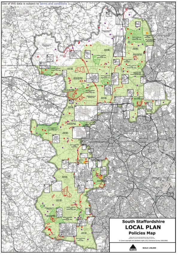
1.
Introduction

FIGURE 1:
                                              AERIAL SITE PLAN

1   LAND OFF LINTHOUSE LANE | WOLVERHAMPTON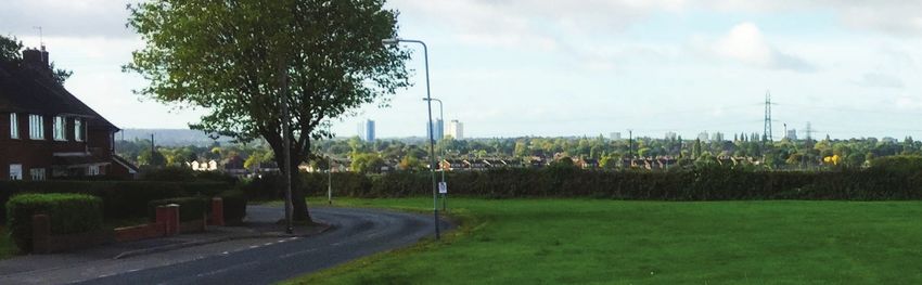
1. Introduction

Land off Linthouse Lane, Wolverhampton,                This document provides a vision for the development       This document includes the following sections:
provides an ideal opportunity to deliver a            of a sustainable residential proposal with significant
                                                                                                                • Section 2 – The Site and Surrounding Area
sustainable, attractive and distinctive residential   areas of public open space and other supporting
development which will deliver homes to help          infrastructure. It explains the technical work that has   • Section 3 – Planning Policy
meet the needs of the local community and the         been carried out by Taylor Wimpey to inform our initial   • Section 4 – Is there a Need for Green Belt
wider housing market area. The site is located        development vision for the site and forms the basis for                 Development?
on the northern edge of Wolverhampton, to the         more detailed consultation with South Staffordshire
                                                                                                                • Section 5 – Is the Site Sustainable?
north of Linthouse Lane and south of Blackhalve       District Council, the Black Country Authorities and
Lane, in South Staffordshire District. The             the local community to refine the proposals as             • Section 6 – What is the Vision for the Site?
site is currently located within the Green Belt       appropriate. The vision will evolve following further     • Section 7 – Conclusion
and is surrounded on three sides by existing          consultation and more detailed technical work.
residential development. The site has potential
                                                      Taylor Wimpey is one of the UK’s leading
for good access to Wolverhampton via a number
                                                      housebuilders, being responsible for the delivery
of vehicular, public transport and pedestrian
                                                      of over 10,000 homes annually. Taylor Wimpey is
connections.
                                                      committed to engaging with local communities to
Taylor Wimpey is a national and respected             shape developments which best meet local needs
housebuilder who is committed to working              and requirements. Further details of our company are
with South Staffordshire District Council, in          set out in Appendix 1.
conjunction with the Black Country Authorities
                                                      This Development Vision Document has been
and the local community, to design a quality and
                                                      prepared in the context of South Staffordshire District
sympathetic development which delivers social,
                                                      Council’s Local Plan Review which is to address
environmental and economic benefits for the
                                                      unmet housing needs in both South Staffordshire and
wider area.
                                                      the wider region, in light of the unmet housing need of
                                                      the Greater Birmingham and Black Country Housing
                                                      Market Area. This Document has also been prepared
                                                      in the context of the Black Country Core Strategy
                                                      Review, which has been subject to an ‘Issues and
                                                      Options’ consultation between 3rd July and 8th
                                                      September 2017.

                                                      Taylor Wimpey has appointed a consultant team
                                                      to assist in producing an appropriate development
                                                      vision for the site. The principal team members
                                                      comprise Pegasus Group (Planning, Masterplanning
                                                      and Landscape Consultants), M-EC (Consultant
                                                      Engineers), EDP (Arboriculture, Ecology, Heritage) and
                                                      Vectos (Transport).

                                                                                                                        LAND OFF LINTHOUSE LANE | WOLVERHAMPTON   2
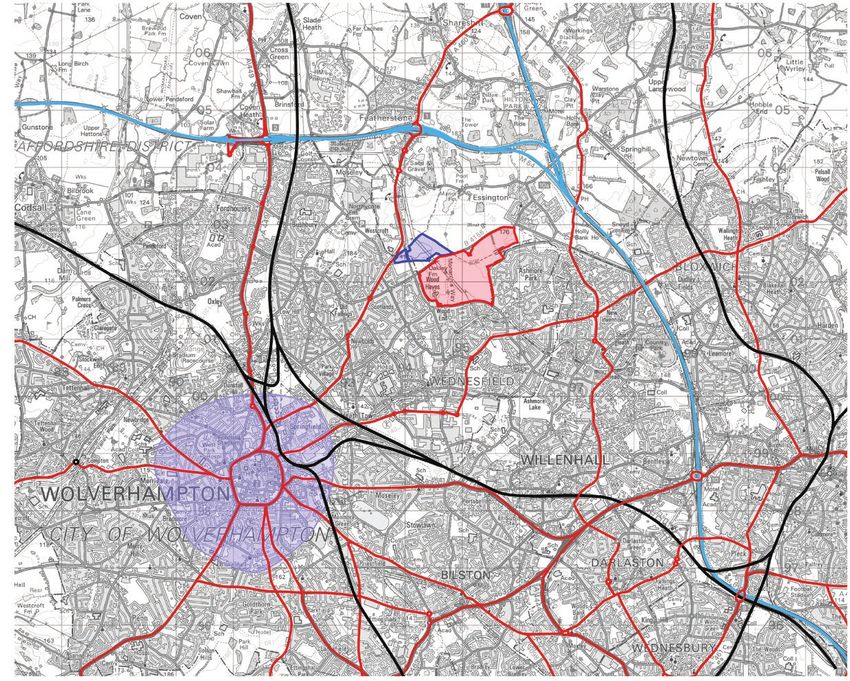
2.
The Site and Surrounding
Area
FIGURE 2:
                                              STRATEGIC LOCATION PLAN

5   LAND OFF LINTHOUSE LANE | WOLVERHAMPTON
2. The Site and Surrounding Area
Site Context and Location
Whilst the site is located within South The site benefits from numerous potential vehicular Wolverhampton itself is a historic settlement, founded
Staffordshire District, it lies immediately and pedestrian access points connecting the site in the 10th century by Lady Wulfrun. Wolverhampton
adjacent to the Black Country city of to the wider area, including Linthouse Lane to the is recorded in the Domesday Book in 1086 as being
Wolverhampton, which itself comprises a south, Kitchen Lane to the east and Blackhalve in the county of Staffordshire.
separate Authority, covered by the Black Lane to the north. Wolverhampton railway station
is located approximately 4km to the south-west The settlement historically grew as part of the
Country Core Strategy. Within the Strategy,
of the site, whilst Bloxwich and Bloxwich North woollen trade, followed by coal and iron industry. A
Wolverhampton is identified as a Strategic
stations are located approximately 4km to the east. large number of council houses were constructed
Centre, along with Brierley Hill, Walsall and
These stations provide access to a variety of local in Wolverhampton following the First and Second
West Bromwich. As such, Wolverhampton is
and national destinations including; Birmingham, World Wars, with a number of flats and apartments
a sustainable location for development and a
London, Manchester, Liverpool, Bristol, Edinburgh being constructed in the 1960s. The area immediately
focus for growth and investment.
and Glasgow. There are a number of bus stops to surrounding the site is characterised by more modern
the south of the site on Linthouse Lane, providing semi-detached housing.
services between Bilston, Walsall, Willenhall,
Pendeford and Wolverhampton, with the potential
to accommodate a number of further stops within
the site itself. Overall, there is significant opportunity
to travel by public transport to Wolverhampton and
beyond.
LAND OFF LINTHOUSE LANE | WOLVERHAMPTON 6PHOTOGRAPHS OF THE SITE AND 1. View North, Wood Hayes Road
2. Junction with Blackhalve Lane and Wood Hayes/End Road
ADJOINING ROADS/INFRASTRUCTURE
3. Linthouse Lane, Wood End Road, Lower Priestwood Road roundabout
4. View East, Linthouse Lane
5. Public right of way running between Blackhalve Lane and Linthouse Lane
6. Kitchen Lane
1 2
3 4
5 6
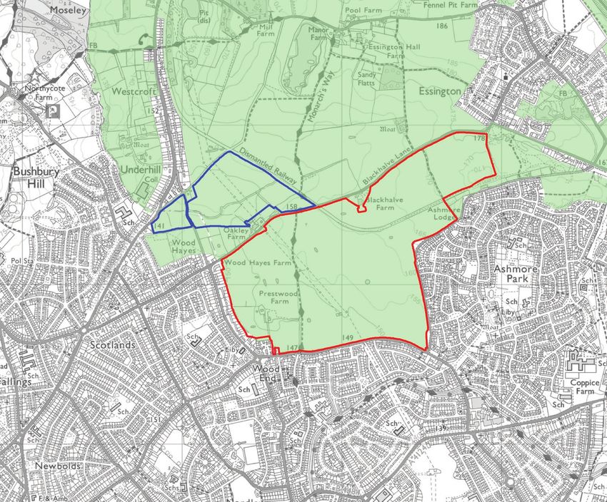
7 LAND OFF LINTHOUSE LANE | WOLVERHAMPTONFIGURE 3: SITE CONTEXT PLAN LAND OFF LINTHOUSE LANE | WOLVERHAMPTON 8
VIEW AROUND THE SITE BOUNDARIES TO THE SOUTH

9   LAND OFF LINTHOUSE LANE | WOLVERHAMPTON
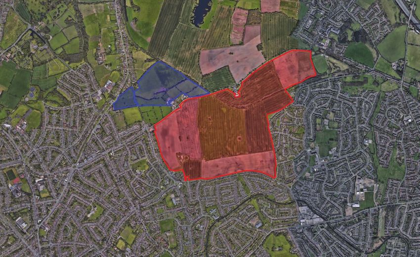
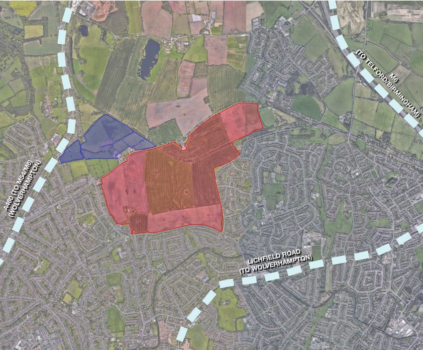
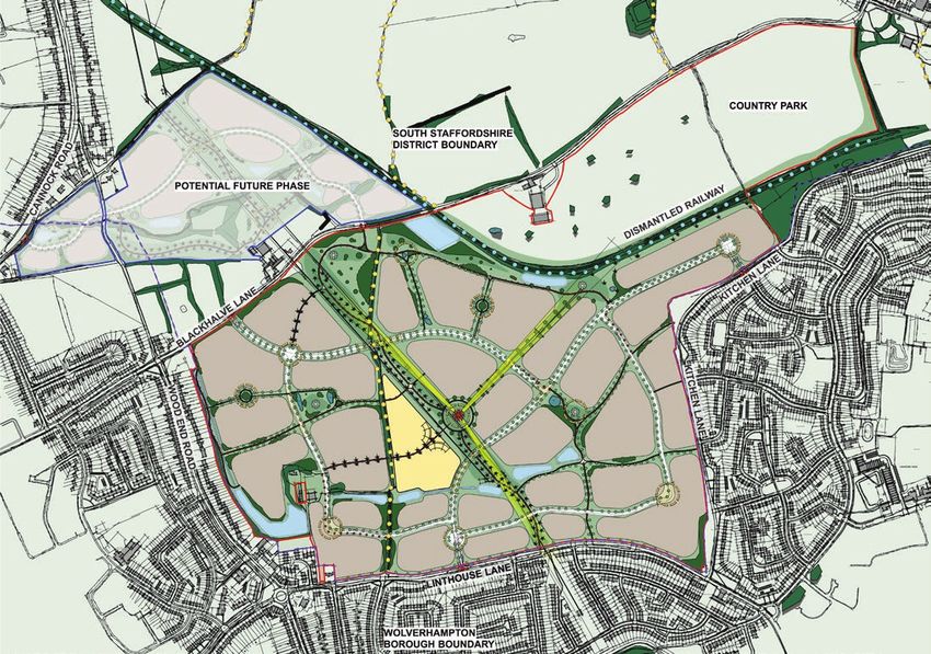
Land Control
The site, edged in red on Figure 4, comprises
approximately 147.81ha of agricultural land to the
north of Wolverhampton. It is well-contained by
existing residential development to the east, south
and west, with the northern boundary comprised in
part of Blackhalve Lane and, in part, of a number of
hedgerows and field boundaries. The smaller parcel
of land to the north of Blackhalve Lane is bounded
by Old Hampton Lane to the north and Wood Hayes
Road to the west. The land adjoins the existing
Major Urban Area where these roads intersect. The
site is curently located within the Green Belt. Open
countryside lies beyond the site’s northern boundary.

The site is bisected by a high voltage electricity line
running north-south from Old Hampton Lane to
Linthouse Lane.

There is an existing Public Right of Way (PRoW)
running north-south from Blackhalve Lane to
Linthouse Lane and a dismantled railway walk
crossing the north-western section of the site.

Character Areas
Three broad character areas are identified within the
vicinity of the site as set out overleaf.

                                                          FIGURE 4:
                                                          LAND CONTROL PLAN

                                                                              LAND OFF LINTHOUSE LANE | WOLVERHAMPTON   10
CA1
1850’s - 1950’s 1. Priestwood Farm House
2. Lynt House - Linthouse Lane
3. Linthouse Lane
4. Kitchen Lane
5. High Hill, Essington
6. High Hill, Essington
1 2
3 4
5 6
11 LAND OFF LINTHOUSE LANE | WOLVERHAMPTONCA2
1960’s, 70’s & 80’s 1. Wood End Road
2. Wood End Road
3. Linthouse Lane
4. Linthouse Lane
5. Springhill Road
6. Sudbury Close
1 2
3 4
5 6
LAND OFF LINTHOUSE LANE | WOLVERHAMPTON 12CA3
Post 1990’s 1. Argil Close
2. Argil Close
3. Wood Hayes Croft
4. Wood Hayes Road
5. Linthouse Lane
6. Buttermere Drive
1 2
3 4
5 6
13 LAND OFF LINTHOUSE LANE | WOLVERHAMPTONServices and Facilities
There are a number of local convenience stores within
the vicinity of the site, with the nearest supermarkets
being located toward either within Wolverhampton
city centre to the south or Bloxwich to the east.
There are a number of primary schools within 1km
of the site, including: Long Knowle Primary School;
Wood End Primary School and Nursery; D’Eyncourt
Primary School; Berrybrook Primary School; and,
Corpus Catholic Primary School. Furthermore,
1 2
Morteton Secondary School, Our Lady and St Chad
Catholic Academy and Coppice Performing Arts
School are located within 2km of the site, whilst
Westcroft School caters for children of all ages with
special educational needs.
There are a number of doctor’s surgeries within a 2km
radius of the site, as well as a number of dentists.
The site is therefore well situated in relation to local
services and facilities.
3 4
1. Wood Hayes Rd parade of shops
2. Betany Chapel
3. Wood End Rd parade of shops
4. The Pheasant Public House - Linthouse Lane
5. Long Knowle Library
6. Linthouse Lane Bus Stop
5 6
LAND OFF LINTHOUSE LANE | WOLVERHAMPTON 143. Planning Policy
FIGURE 5:
                                               SOUTH STAFFORDSHIRE CORE
                                               STRATEGY POLICIES MAP

17   LAND OFF LINTHOUSE LANE | WOLVERHAMPTON
3. Planning Policy
National Planning Policy
A new National Planning Policy Framework (NPPF) The Site Allocations Document (SAD) commits the
was introduced in July 2018. The Government District Council to carrying out an early review of
recognises that the planning system should be the development plan in order to respond to the
genuinely plan-led, with succinct and up-to-date local increasing need for development, both within South
plans providing a positive vision for each District; a Staffordshire and the wider housing market area. The
framework for addressing housing needs and other SAD also requires a new Local Plan to be submitted
economic, social and environmental priorities that for an Examination in Public (EiP) by 2021. Local Plan Issues and Options
span a minimum 15 year period from adoption. October 2018
Taylor Wimpey supports the District Council’s decision
The NPPF requires local authorities to identify a to carry out a review to ensure an up to date planning
sufficient amount and variety of land, that can policy framework is in place to shape the District to
come forward where it is needed, to support the 2037. The review provides an opportunity to address
Government’s aim of significantly boosting the housing need, reflect new national planning guidance
supply of homes. To determine the number of homes and provide a meaningful contribution to meeting
needed a local housing need assessment is required, needs of neighbouring authorities, where it can be
conducted using the ‘standard method.’ This demonstrated that they are unable to do so.
standard method identifies a housing need for South
Further information can be found at
www.sstaffs.gov.uk
The Local Development Scheme (LDS) published
Staffordshire District of 270 dwellings per annum,
in 2018, proposed the following timetable for the
including an uplift to take account of market signals
Review:
and affordability.
South Staffordshire Local
Plan Review Issue & Options Autumn 2018
Preferred Spatial Strategy &
The South Staffordshire development plan currently Spring 2020
Sites Document
comprises the South Staffordshire Core Strategy
(adopted in December 2012) and the South Publication of Draft Plan Winter 2020/21
Staffordshire Site Allocations Document (adopted in
September 2018). The current Strategy covers the Submission of Plan to SoS Autumn 2021
period 2006-2028 and sets a housing requirement of
Local Plan Examination Winter 2021/22
at least 3,850 new homes to be delivered within this
period which at 175 dpa is considerably lower than
Adoption of Plan Summer 2022
the need that has now been identified.
LAND OFF LINTHOUSE LANE | WOLVERHAMPTON 18Black Country Local
Plan Review Evidence
The Black Country Local Authorities have embarked It is recognised that the Local Plan Review will be
on a review of the Core Strategy, also in response to informed by a range of evidence to inform the spatial
the duty-to-cooperate and the unmet housing needs development strategy, policies and site selection.
of the Greater Birmingham Housing Market Area.
Housing Need: National guidance states that
The Black Country Issues and Options Consultation assessing housing need is the first step in the process
took place between 3rd July and 8th September of deciding how many homes need to be planned for.
2017, with the remainder of the Local Plan Review It should be undertaken separately from assessing
currently anticipated to follow the timetable below: land availability, establishing a housing requirement
figure, and preparing policies to address this such as
site allocations. The NPPF expects strategic policy-
Publication of Draft Plan Oct/Nov 2019
making authorities to follow the standard method as
a starting point in determining the number of homes
Publication Plan February 2020
needed in an area.
Submission of Plan to SoS Dec 2020 An uplift in housing need may be appropriate where
growth strategies are in place; where strategic
Local Plan Examination Spring 2021 infrastructure is planned that could support new
homes; or where a Local Authority has agreed to
Adoption of Plan Autumn 2021
meet unmet need from neighbouring authorities.
Cross Boundary Needs: Local Planning Authorities
Due to the functional relationship between land off
have a duty to cooperate with neighbouring
Linthouse Lane and Wolverhampton, Taylor Wimpey
authorities and other prescribed bodies on strategic
will engage fully with the Black Country Core Strategy
matters that cross administrative boundaries. The
Review.
most significant cross boundary issue relates to
unmet housing needs within the Greater Birmingham
Housing Market Area (GBHMA) in which South
Staffordshire District lies.
19 LAND OFF LINTHOUSE LANE | WOLVERHAMPTONSouth Staffordshire District Council and the Black
Country Authorities have worked with the other Local
Planning Authorities within the Greater Birmingham
Housing Market Area (GBHMA) to consider the
housing need across the HMA and consider the
strategic development options for meeting this
identified need. The Strategic Growth Study (SGS)
identified between 256,00 and 310,000 new homes
are required to meet the HMA’s needs between 2011
and 2036 and a cumulative shortfall in the supply of
60,855 planned dwellings across the HMA to 2036.
This document identifies a number of growth options
within local authority areas to be tested through local
plan reviews. Many of these options have implications
for Green Belt.
Green Belt Review: Approximately 80% of land
within South Staffordshire District lies within the West
Midlands Green Belt. An important element of the
evidence base to inform both the South Staffordshire
Local Plan Review and the Black Country Core
Strategy Review will be a Green Belt Review that has
been jointly commissioned by South Staffordshire
District Council and the Black Country Authorities.
LAND OFF LINTHOUSE LANE | WOLVERHAMPTON 204. Is There a Need For Green Belt Development?
FIGURE 6:
                                               GREEN BELT PLAN

23   LAND OFF LINTHOUSE LANE | WOLVERHAMPTON
4. Is There a Need For
Green Belt Development?
As explained in Section 3, the submitted Site 1. To check the unrestricted 2. To prevent neighbouring
Allocations Plan confirms that South Staffordshire
District Council is in the process of preparing a
sprawl of large built-up areas towns merging into one another
Strategic Green Belt Review as part of the Local Plan The site is bounded on three of its four sides by The nearest settlement to the site is the village of
Review evidence base. It is hoped that this Vision residential properties, which form part of the Black Essington, which is some 100 metres from the
Document will assist this Study. Country conurbation (eastern, western and southern north-eastern red-line boundary. However, Essington
boundaries). To the north, the site is bounded in part shares a functional relationship with the Black Country
The view is taken that the housing need arising from by Blackhalve Lane, a dismantled railway line and conurbation, which it is connected to via High Hill/
the Greater Birmingham and Black Country Housing further existing residential properties. These features Kitchen Lane/Upper Sneyd Road. Nevertheless,
Market Area (GBHMA) will amount to the exceptional present an opportunity to further strengthen this Essington is surrounded by Green Belt, which
circumstances required to justify releasing land from boundary, through the provision of open space and disconnects the village from Sneyd Road.
the Green Belt, as set out within the NPPF. This landscaping features.
would be achieved through the Local Plan Review The next nearest settlement is the village of
to ensure that housing needs are met in a timely and The site would therefore be well contained and not Featherstone, approximately 2.5km to the north-west
sustainable manner. encourage sprawl beyond the period of the Local of the site off junction 1 off the M54. Featherstone
Plan Review. is separated from the site via the Green Belt, in
The 2014 partial Green Belt Review confirms that conjunction with the physical boundary of the M54
around 80% of South Staffordshire District is included Accordingly, the release of the site from the Green
motorway.
in the West Midlands Green Belt, which surrounds Belt will not result in the unrestricted sprawl of
the major settlements within the District as well as the Wolverhampton or the Black Country conurbation; Hilton Main Industrial Estate and Hilton Cross
Black Country to the south. it will instead serve to ‘round-off’ the conurbation’s Business Park are located to the south of junction 1
northern boundary. of the M54, approximately 1.5km to the north of the
We have considered the release of the site from the site. These are both surrounded by Green Belt.
Green Belt in the context of the five purposes of the
Green Belt as set out in the NPPF: The proposed Indicative Masterplan demonstrates
how it is possible for the site to be developed without
reducing the existing separation distance between
the nearest neighbouring settlements (Essington
and Hilton Industrial Estate/Business Park) and
the existing Black Country conurbation. Due to
the ‘recessed’ shape of the existing built form, it is
possible for development to sit ‘within’ the prevailing
development envelope of the conurbation, to the
south of Blackhalve Lane and the dismantled railway.
Therefore, the release of this site will not result in the
merging of any neighbouring towns, as a significant
Green Belt gap will remain.
LAND OFF LINTHOUSE LANE | WOLVERHAMPTON 243. To assist in safeguarding the 4. To preserve the setting and 5. To assist in urban
countryside from encroachment special character of historic towns regeneration, by encouraging the
The creation of strong, defensible boundaries Whilst Wolverhampton is a historic canal City which recycling of derelict and other
is important in protecting the countryside from contains 31 conservation areas and associated listed urban land
encroachment. While it is acknowledged that, in buildings, these are not located within close proximity
The release of this land from the Green Belt would not
theory, the release of any land from the Green Belt of the site and, as such, the site does not make a
prevent the recycling of derelict and other urban land.
could result in encroachment into the countryside, significant contribution to fulfilling this purpose of the
The adopted Core Strategy allocates a significant
it is considered that the site offers the opportunity Green Belt.
amount of brownfield land for redevelopment.
to provide strong and defensible boundaries which
Several listed buildings exist to the south and west However, the supply of suitable brownfield land is
will protect the countryside and maintain the visual
of the site, within the Wolverhampton urban area. now reducing. Therefore, a Green Belt review is to
and physical separation between Wolverhampton/
These predominantly comprise Grade II Listed be undertaken as part of the Local Plan Review, in
the Black Country conurbation and surrounding
Buildings such as public houses, however, the Old order to meet housing needs. The development of the
settlements. This is evidenced by the significant
Fallings Hall as part of Our Lady and St Chad Roman site can be appropriately phased within the housing
landscape buffer on the northern boundary of the site,
Catholic School is Grade II* Listed and is located trajectory to take account of the availability and
as shown on the Indicative Masterplan.
approximately 1.6km to the west of the site. deliverability of brownfield sites across the District.
The release of this site from the Green Belt will
Nevertheless, these buildings are well screened from The release of the site from the Green Belt will
not compromise the purpose of safeguarding the
the site due to the presence of urban built form in the therefore not prejudice the recycling of derelict and
countryside from encroachment.
separation distance. The site accordingly has a limited other urban land.
contribution towards the setting and special character
of historic towns.
As such, the release of this site from the Green Belt
will not compromise the setting or special character of
any historic towns.
25 LAND OFF LINTHOUSE LANE | WOLVERHAMPTONSummary
It has been demonstrated that the release of the
site from the Green Belt would not compromise the
five purposes of Green Belt land as set out within
the NPPF and is entirely in accordance with national
policy regarding the release of land from the Green
Belt. The site is capable of being well contained
within strong, defensible boundaries and will, as a
result, minimise encroachment into the countryside
while maintaining the clear visual separation between
Wolverhampton, the Black Country conurbation and
neighbouring settlements. It would not compromise
the setting of the town and would not prejudice the
recycling of derelict and other urban land. Therefore,
it is considered that the site represents appropriate
Green Belt release to deliver residential development
in a sustainable location.
LAND OFF LINTHOUSE LANE | WOLVERHAMPTON 265. Is the Site Sustainable?
You can also read