LAVENDER AND HARPER BEACH ACCESS
←
→
Page content transcription
If your browser does not render page correctly, please read the page content below
LAVENDER AND HARPER

   BEACH ACCESS

      DESIGNS

       2021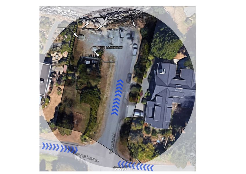
CONTEXT ANALYSIS
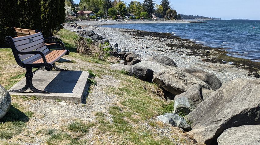
Park benches
• Harper Rd beach end is located be-
tween Huddle Stone Rd and Sebastian Rd
Ditch
• It is surrounded by private proper-
ties, with Harper road forming the
only vehicular and pedestrian access.
• There is no dedicated parking for bikes or cars.
Harper Rd
• The beach access has two bus
stops within 500m walking distance.
• At the bottom of the beach access, the
submersion of ground soil creates a ditch
Lavender Rd
due to historic underground mines. The
ditch is flooded during the winter months.
-Heavy Traffic
Main Road
-Low Traffic
-Bus Stops
Major Access to Site
ENVIRONMENTAL ANALYSIS
• The microclimate on the site is not com-
Original Site (Change Image) fortable during the winter months due
to heavy winds, rainfall and a drop in
temperature to an average of 2 °C.
• There is no major vegetation on-site to
break the wind or provide shade during
the summer months. The only vegetation
along the site consists of 8 feet tall hedges.
Lantzville Beach Access Greenifying Project 2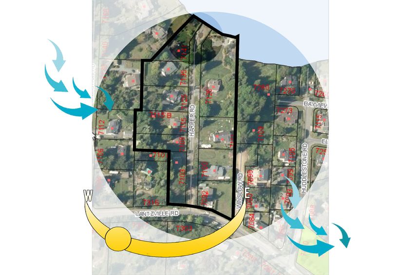
d BeachMAJOR   THEMES FROM COMMUNITY ENGAGEMENT

                                                                                                                     ²
        End Legend                         1:250
                                  1 centimeter = 2.5 meters
                                                                                                                           Data Source: RDN,
                                    Contour (1 metre)            0   10        20             30         40     50         DataBC, ESRI
                                                                                                                           Basemap (2018)
                                    Lantzville Parcel Boundary                       metres                                Date: January 2021

                                                                                                   High Priority Interventions:

                                                                                                   1. Protect the beach end from further

                                                                                                        deterioration and erosion caused due to

                                                                                                        sea- level rise.

                                                                                                   2. Improve drainage at the bottom of the
   7

                                                                                                        beach end.

                                                                                                   3. Make the public space safer.
                                                                                                          1

                                                                                                   4. Improve and regulate parking on site.
                                                                                                          2

                                                                                                         3

EBASTION RD
                                                                                                         4

                                                                                                   Amenities desired on site:
                                                                                                         5

                                            9
                                                                                                         6

                                                                                                   Mobility
                                                                                                   1. Improve walkability
                                7141 HARPER RD

                                                                                                   2. Bike racks

                                                                                                   3. Improve parking
                      11
                                                                                         8

                                                                                                   Recreation
              7135 HARPER RD

                                                                                                   1. Kayak/Paddle board launch

                                                                                                   2. Green space for picnicking
                               14

                               15
                                                                                                   10

                               16
                                                                          7126 HARPER RD
                                                                                                   Services
                                                                                    12

                                                                                                   1. Recycling bin

              Lantzville Beach Ends Greenifying Project                                                                                           3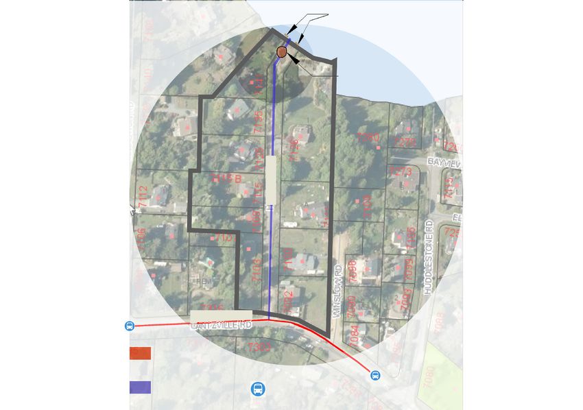
HARPER ROAD SITE PLAN – REDESIGNED
Green shore approach to keep
the beach access in its natural
state.
Future expansion for additional
amenities (like kids' play area)
Recycling bin
Added picnic bench.
Planted a series of native trees,
flower beds, and shrubs to
improve drainage at the bottom of
the site.
Added culvert to drain water from
LO
A
NO DING
the ditch
PA ZO
RK NE
ING
Loading Zone
Bike storage to improve mobility
options.
Restricted the vehicular access
by bollards to reduce soil run off
ACCESSIBLE
PARKING and improving drainage.
Accessible parking
7141
Added sidewalk to improve
walkability.
Right side parallel parking only.
7135
Entrance
Property
Private
Entrance
Property
Private
Added speed bump for traffic
calming.
Sidewalk and parking can be
extended through the entire
stretch of Harper Road.
HARPER ROAD SITE PLAN
MOUNT ARROWSMITH DWG NAME: HARPER RD PLAN
Graphical Scale
BIOSPHERE REGION RESEARCH Notes: Project Supervisor: Becky Thiessen
INSTITUTE (MABRRI)
0 1 2 3 4 5 10 m Drawn by: Aishwarya Pathania
N
900 FIFTH ST,
Date: May 17th 2021
NANAIMO, BC V9R 5S5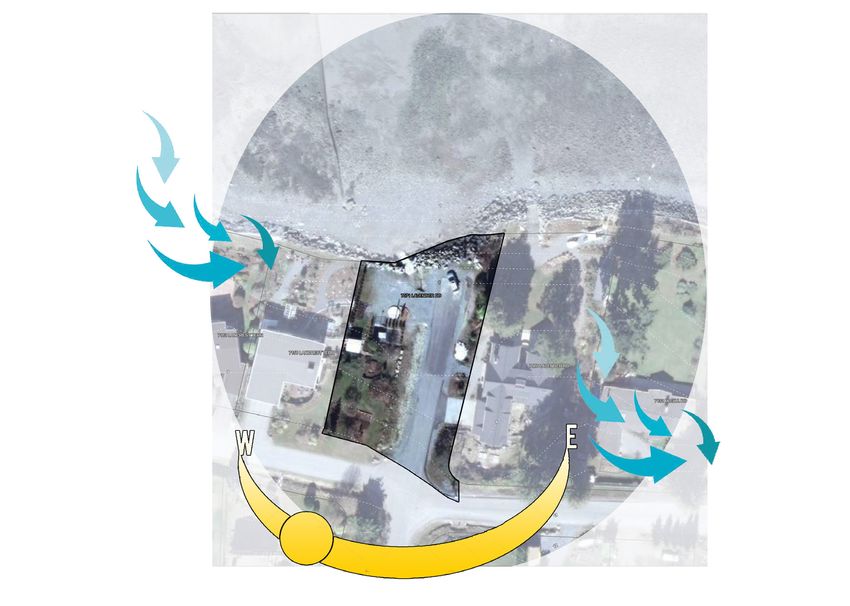
Green shore approach to keep
the beach access in its natural
state.
Future expansion for additional
amenities (like kids' play area)
HARPER ROAD SITE PLAN – REDESIGNED Recycling bin
Green shore approach to keep High Priority Interventions:
the beach access in its natural
state.
Added picnic bench. 1. Reinforced with the greenshore
Future expansion for additional
amenities
Planted a (like
serieskids' play area)
of native
flower beds, and shrubs to
trees, approach.
improve drainage at the bottom of
Recycling bin
the site.
2. Blocked vehicular access with
Added culvert to drain water from
bollards to avoid further erosion.
LO
A
NO DING
the ditch
PA ZO
RK NE
3. Created a continuous greens-
ING
Added picnic bench.
Loading Zone
Bike storage to improve mobility
options.
Planted a series of native trees,
flower beds, and shrubs to pace
Restricted the vehicular
improve drainage access
at the bottom of
bythe
bollards
site. to reduce soil run off
4. Added water retaining native
ACCESSIBLE
PARKING and improving drainage.
Accessible parking
LO
A
Added culvert to drain water from
the ditch
plant species on both sides of
NO DING
PA ZO
RK NE
ING
Loading Zone
Bike storage to improve mobility
the parklet.
options.
Restricted the vehicular access
5. Added a culvert to drain the wa-
by bollards to reduce soil run off
ACCESSIBLE
and improving drainage.
ter collecting in the ditch.
PARKING
Accessible parking
Added sidewalk to improve
walkability.
Right side parallel parking only.
Amenities added on site:
Mobility
Added sidewalk to improve
walkability.
1. Added speed bump for traffic
calming.
2. Added sidewalk to promote walk-
Right side parallel parking only.
ability.
3. Added bike racks to promote
biking.
Recreation
1. Added Kayak/Paddle board
launcch
Entrance
Property
Private
Entrance
Property
Private
Services
1. Recycling bin
Added speed bump for traffic
Entrance
calming.
Property
Private
5
Entrance
Property
Private
Lantzville Beach Access Greenifying Project
Sidewalk and parking can be
extended through the entire
stretch of Harper Road.
CONTEXT ANALYSIS
                                                 •   Lavender Rd beach end is located be-
                  Benches

Picnic Bench                                         tween Lancester Terrace and McGill road

                                                 •   It is surrounded by private properties, with

                                                     Lavender road forming the only vehicu-

                                                     lar access. There is no dedicated park-
                   Sewage Station

                                                     ing, but people usually park their cars

                                                     along the right side of lavender rd and to-

                                                     wards the right       edge of the beach end.

                                                 •   There are three benches, as can be seen

                                                     in the map and picnic bench on the right.

                                                     There is also a sewage treatment plant and
                                                     an electric station (correct me if I am wrong).

                                                 •   There     are    no     dedicated   sidewalks,

                                                     and     bike    paths   on   Lavender    road.
ENVIRONMENTAL ANALYSIS

  ENVIRONMENTAL ANALYSIS                         •   The microclimate on the site is not comfortable

                                                     during winter months due to heavy winds, rainfall

                                                     and a drop in temperature to an average of 2 °C.

                                                 •   There is no major vegetation along the front edge

                                                     to break the wind or provide shade during sum-

                                                     mer months. On the map you can see the line of

                                                     subdivisions, and towards the left there is green

                                                     cover, which is also part of beach end itself.

   Lantzville Beach Access Greenifying Project                                                   6
MAJOR THEMES FROM COMMUNITY ENGAGEMENT

                                                               High Priority Interventions:
                                                      1

                                                      2
                                                               1. Sea wall erosion

                                                      3        2. Lack of safety
                                                     4
                                                               3. Ramp eroding at the bottom of the
                                                     5
                                                                    beach end.
                                                     6
                                                               4. Cars blocking access to the ramp and
                                       7071 LAVENDER RD

                                                                    the water pump for emergency vehicles.

                                                               5. Make the public space safer.
R

         7158 LANCREST TERR
                                                               Amenities desired on
                                                                                 7
                                                                                    site:

                                                               Mobility
                                                              7068 LAVENDER RD

                                                               1. Improve walkability

                                                               2. Bike racks                   7132 McGILL RD

                                                               3. Improve parking
                                                          8

                                                               4. Traffic calming measures

                                                                                          10
                                                               Recreation
                                                               1. Kayak/Paddle board launch

                                                                        11

                  13
                                                               Services
                                                               1. Recycling
                                                                   12       bin
LAVENDER RD

              Lantzville Beach Ends Greenifying Project                                                     7
LAVENDER ROAD SITE PLAN – REDESIGNED

                                                  Fix existing ramp

                                                                                                                                                                    Added recycling bin
                                     Bollards operated by keys
                                   restricting vehicular access.
                                   Emergency vehicles can still
                                 access the pump adjoining the                                                                                                         Add parking sign
                                                  sewer station.
                                            Add no parking sign.
                                                                                                                     ACCESSIBLE
                                                                                                                      PARKING

                                                                                                                                                                     Accessible Parking

                                Bike storage to improve mobility
                                                        options

                                           Existing sewer station

                                         Existing electric station

                                                                                                     LOAD
                                                                                                          ING
                                                                                                      NO PA ZONE
                                                                                                            RKING

                                     Remove existing staircase

                                                                                                                                                               Loading zone. No parking

                                                                                                                                         Entra y
                                                                                                                                                 te

                                                                                                                                              nce
                                                                                                                                               ert
                                                                                                                                           Priva
                              Leveling landscaping to created a

                                                                                                                                          Prop
                                                 smooth slope

                                              Added picnic table

                            Shifting landscaping to the back
                             to cover and provide privacy for
                                       the adjacent property.
                            The shift of landscaping will also
                                                                                                                                  Entra y
                                                                                                                                          te

                                                                                                                                       nce
                                                                                                                                        ert

                                open up the green space and
                                                                                                                                    Priva
                                                                                                                                   Prop

                            make it obvious that it is a public
                                                        space.

                                                                                                                                                             Added sidewalk to improve
                                                                                                                                                                            walkability

MOUNT ARROWSMITH                       DWG NAME: LAVENDER RD PLAN
                                                                          Graphical Scale
BIOSPHERE REGION RESEARCH                                                                                           Notes:                            Project Supervisor: Becky Thiessen
INSTITUTE (MABRRI)
                                                                          0   1   2   3   4   5   10 m                                                Drawn by: Aishwarya Pathania

                                                                      N
900 FIFTH ST,
                                       Date: May 17th 2021
NANAIMO, BC V9R 5S5
LAVENDER ROAD SITE PLAN – REDESIGNED

                      Fix existing ramp

                                                                                                                                                Added recycling bin
         Bollards operated by keys
       restricting vehicular access.
       Emergency vehicles can still
     access the pump adjoining the                                                                                                                 Add parking sign
                      sewer station.
                Add no parking sign.
                                                                                                 ACCESSIBLE
                                                                                                  PARKING

                                                                                                                                                 Accessible Parking

    Bike storage to improve mobility
                            options

               Existing sewer station

             Existing electric station

                                                                                  LOADING
                                                                                   NO PA ZONE
                                                                                        RKING

         Remove existing staircase

                                                                                                                                           Loading zone. No parking

                                                                                                                     Entra y
                                                                                                                             te

                                                                                                                          nce
                                                                                                                           ert
                                                                                                                       Priva
  Leveling landscaping to created a

                                                                                                                      Prop
                     smooth slope

                  Added picnic table

Shifting landscaping to the back
 to cover and provide privacy for
           the adjacent property.
The shift of landscaping will also                                                                            Entra y
                                                                                                                      te

                                                                                                                   nce
                                                                                                                    ert
    open up the green space and
                                                                                                                Priva
                                                                                                               Prop

make it obvious that it is a public
                            space.

                     High Priority Interventions:                                      Amenities added on site:

                     1. Provided dedicated parking to                                                                                    Added sidewalk to improve
                                                                                                                                                        walkability

                             the left, where the existing cul-                         Mobility
                             vert is.                                                  1. Added bike racks to promote

                     2. Blockd access to the water pump                                         biking.

                             and ramp through bollards.
           DWG NAME: LAVENDER RD PLAN
                                                       Graphical Scale
                                                                                       Recreation
                                                                                                Notes:                            Project Supervisor: Becky Thiessen

                     3. Provided only single parking slot
                                                       0   1   2   3   4   5   10 m    1. Fixing the existing Kayak/Paddle        Drawn by: Aishwarya Pathania
           Date: May 17th 2021
                                             N
                             (accessible parking slot) at the                                   board launcch ramp.

                             front to stop further erosion.

                                                                                       Services
                                                                                       1. Added recycling bin

       Lantzville Beach Access Greenifying Project                                                                                                          9
restricting vehicular access.
Emergency vehicles can still
access the pump adjoining the Add parking sign
sewer station.
Add no parking sign.
ACCESSIBLE
PARKING
Accessible Parking
LAVENDER ROAD SITE PLAN – REDESIGNED
Bike storage to improve mobility
options
Existing sewer station
Existing electric station
LOADING
NO PA ZONE
RKING
Remove existing staircase
Loading zone. No parking
Entra y
te
nce
ert
Priva
Leveling landscaping to created a
Prop
smooth slope
Added picnic table
Shifting landscaping to the back
to cover and provide privacy for
the adjacent property.
The shift of landscaping will also
Entra y
te
n ce
ert
open up the green space and
Priva
Prop
make it obvious that it is a public
space.
Added sidewalk to improve
walkability
DWG NAME: LAVENDER RD PLAN
Graphical Scale
Notes: Project Supervisor: Becky Thiessen
0 1 2 3 4 5 10 m Drawn by: Aishwarya Pathania
Date: May 17th 2021
N
High Priority Interventions: Amenities added on site:
1. Clearly marking public and pri- Mobility
vate space by moving landscap- 1. Added sidewalk to promote walk-
ing to the back. The adjacent ability.
property line can be covered with 2. Added bike racks to promote
Douglas Fir trees. biking.
2. Levelling the newly opened land-
scape area to create a gradual
slope from the North-West edge.
3. Added picnic bench and a reg-
ular bench that are facing the
water.
Lantzville Beach Access Greenifying Project 10You can also read