Loss of control and collision with water involving Bell UH-1H helicopter, VH-UVC - ATSB Transport Safety Report
←
→
Page content transcription
If your browser does not render page correctly, please read the page content below
Loss of control and collision with
water involving Bell UH-1H
helicopter, VH-UVC
5 km south-west of Anna Bay, New South Wales, on 6 September 2019

 ATSB Transport Safety Report
 Aviation Occurrence Investigation (Defined)
 AO-2019-050
 Final – 23 June 2021
Cover photo:       Mark Watterson

Released in accordance with section 25 of the Transport Safety Investigation Act 2003

Publishing information
Published by:            Australian Transport Safety Bureau
Postal address:          PO Box 967, Civic Square ACT 2608
Office:                  62 Northbourne Avenue Canberra, ACT 2601
Telephone:               1800 020 616, from overseas +61 2 6257 2463
                         Accident and incident notification: 1800 011 034 (24 hours)
Email:                   atsbinfo@atsb.gov.au
Website:                 www.atsb.gov.au

© Commonwealth of Australia 2021

Ownership of intellectual property rights in this publication
Unless otherwise noted, copyright (and any other intellectual property rights, if any) in this publication is owned by the
Commonwealth of Australia.

Creative Commons licence
With the exception of the Coat of Arms, ATSB logo, and photos and graphics in which a third party holds copyright,
this publication is licensed under a Creative Commons Attribution 3.0 Australia licence.

Creative Commons Attribution 3.0 Australia Licence is a standard form licence agreement that allows you to copy,
distribute, transmit and adapt this publication provided that you attribute the work.
The ATSB’s preference is that you attribute this publication (and any material sourced from it) using the following
wording: Source: Australian Transport Safety Bureau

Copyright in material obtained from other agencies, private individuals or organisations, belongs to those agencies,
individuals or organisations. Where you want to use their material you will need to contact them directly.

Addendum

    Page                Change                                                                          Date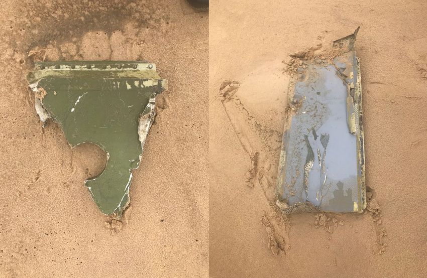
Safety summary
What happened
On 6 September 2019, at 1430 Eastern Standard Time, 1 the pilot of a Bell Helicopter Company
UH-1H helicopter registered VH-UVC (UVC) departed Archerfield Airport, Queensland, on a
private flight with four passengers for Bankstown, New South Wales.
Following a refuelling stop at Coffs Harbour, New South Wales, the pilot made contact with
Williamtown air traffic control (ATC), while north-east of Broughton Island and requested
clearance to track south via the visual flight rules (VFR) coastal route. The initial radio calls
between the pilot and Williamtown ATC, occurred about 6 minutes prior to the published time of
last light. The radio calls indicated that the helicopter was being affected by turbulence and as a
result the pilot was having difficulty maintaining a constant altitude. In response, the controller
issued a clearance for the aircraft to operate between 2,400 and 3,500 ft.
Once past Anna Bay, and about 11 minutes past published last light, UVC was observed on
Williamtown ATC radar to make a left turn to the south, depart the coastal route and head
offshore, on a direct track to Bankstown Airport. The turn likely resulted in the pilot losing visual
cues and encountering dark night conditions.
The helicopter continued to track offshore to the south-west for about 90 seconds, maintaining
between about 2,500 and 3,200 ft before commencing a rapidly descending, left spiral turn. It
disappeared from Williamtown radar coverage about 12 minutes after published last light.
Attempts by the controller to contact the pilot were unsuccessful and authorities were
subsequently advised of a missing helicopter.
On 25 September 2019, wreckage from the destroyed helicopter was located in about 30 m of
water, 5 km south-west of Anna Bay. Two of the five persons on board the helicopter were
confirmed to have received fatal injuries. The bodies of the pilot and two of the passengers were
not found but they were presumed to have similarly not survived the accident.

What the ATSB found
The ATSB found that the pilot continued to fly after last light without the appropriate training and
qualifications, and then into dark night conditions that provided no visual cues. That significantly
reduced the pilot's ability to maintain control of the helicopter, which was not equipped for night
flight.
Once visual references were lost, the pilot likely became spatially disorientated and lost control of
the helicopter, resulting in a collision with water.
Further, the pilot did not disclose on-going medical treatment for significant health issues to the
Civil Aviation Safety Authority. That prevented specialist consideration and management of the
on-going flight safety risk the medical conditions and prescribed medications posed.

Safety message
Various ATSB research and investigation reports refer to the dangers of flying after last light
without the appropriate qualifications and experience. The ATSB report,
Avoidable Accidents No. 7, highlights the risks of visual flight at night. Risks include, reduced
visual cues, increased likelihood of perceptual illusions, and spatial disorientation.

1
    Eastern Standard Time (EST): Coordinated Universal Time (UTC) +10 hours
                                                       ›i‹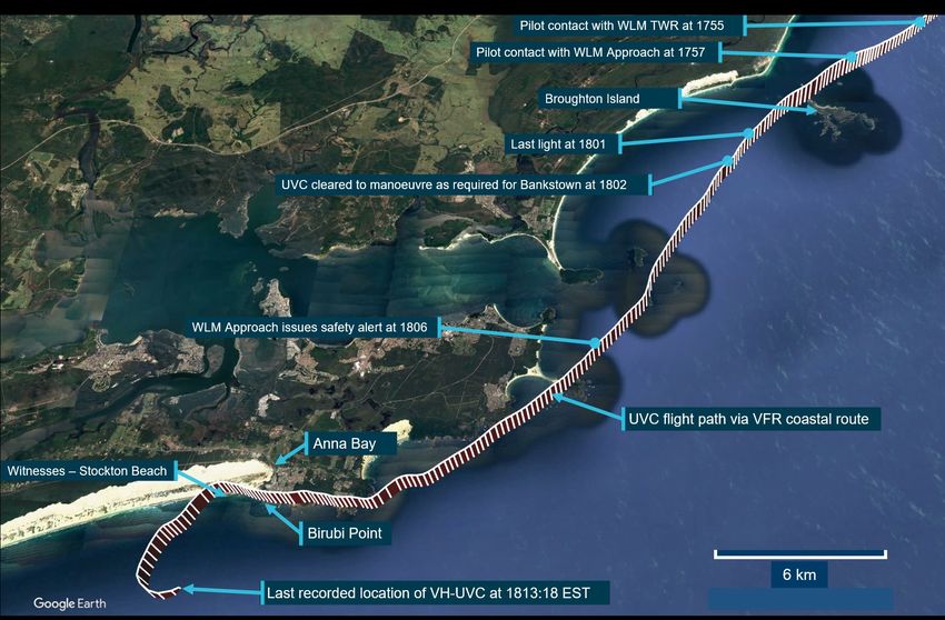
A VFR flight in dark night conditions should only be conducted by a pilot with instrument flying
proficiency as there is a significant risk of losing control if attempting to fly visually in such
conditions. If day VFR-rated pilots find themselves in a situation where last light is likely to occur
before the planned destination is reached, a diversion or precautionary landing is probably the
safest option. Air traffic control assistance with available landing options is also available.
This accident also highlights the importance of aviation medical certificate holders reporting
relevant conditions and medications to their Designated Aviation Medical Examiner. A full
understanding by the Civil Aviation Safety Authority’s aviation medical specialists of a pilot’s
medical conditions, and use of medications, enables management of the risk for both the
individual and flight safety overall.

                                                  › ii ‹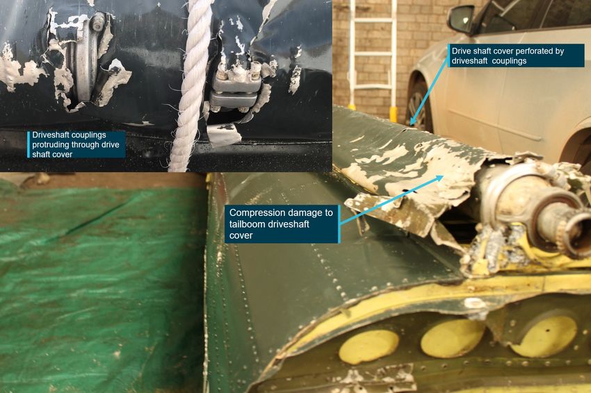
Contents
  Safety summary ........................................................................................................................i
  The occurrence ........................................................................................................................1
  Context ......................................................................................................................................5
    Pilot information                                                                                                                           5
              72-hour history                                                                                                                  5
              Aviation medical certificates                                                                                                    6
       Aircraft information                                                                                                                    6
              General information                                                                                                              6
              Aircraft records                                                                                                                 7
              Aircraft systems                                                                                                                 8
              UH-1H helicopter limitations                                                                                                     9
       Wreckage information                                                                                                                    9
              Search for helicopter and wreckage field                                                                                        9
              Helicopter wreckage                                                                                                            10
              Tailboom assessment                                                                                                            12
       Recorded data                                                                                                                         13
              Overview                                                                                                                       13
              VH-UVC flight path                                                                                                             14
       Air traffic services                                                                                                                  18
       Operational information                                                                                                               18
              Flight endurance                                                                                                               18
              Pilot access to weather information                                                                                            19
              Night VFR (Helicopter) qualification and training                                                                              19
              Decision making                                                                                                                19
              Weight and Balance                                                                                                             20
              Helicopter – basic operational equipment for flight under the night VFR                                                        20
              Helicopter emergency procedures                                                                                                21
       Meteorological information                                                                                                            22
              Forecast weather                                                                                                               22
              Actual weather                                                                                                                 23
              Last light                                                                                                                     24
       Spatial disorientation                                                                                                                24
              Vestibular system illusion                                                                                                     26
       Related Occurrences                                                                                                                   26
  Safety analysis ...................................................................................................................... 29
     Introduction                                                                                                                        29
     Flight after last light                                                                                                             29
     Loss of control                                                                                                                     29
     Reporting of medication and medical conditions to the Civil Aviation Safety
         Authority                                                                                                                       31
  Findings ................................................................................................................................. 32
     Contributing factors                                                                                                                    32
     Other factors that increased risk                                                                                                       32
  General details ...................................................................................................................... 33
  Sources and submissions .................................................................................................. 34
    Sources of information                                                                                                   34
    References                                                                                                               34
    Submissions                                                                                                              35
  Australian Transport Safety Bureau .................................................................................. 36

                                                                  › iii ‹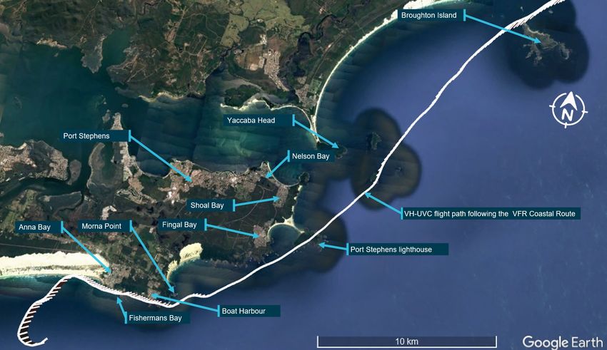
› iv ‹
ATSB – AO-2019-050
The occurrence
On 6 September 2019, at 1430 Eastern Standard Time, 2 the pilot of a Bell Helicopter Company
UH-1H helicopter registered VH-UVC (UVC) departed Archerfield Airport, Queensland, with four
passengers on board. The pilot was conducting a private flight for the purpose of repositioning the
helicopter to Bankstown Airport, New South Wales (NSW).
Witnesses at Archerfield advised that the intent was for UVC to be self-sufficient in terms of fuel
requirements during the transit to Bankstown. Pre-flight preparation included the loading and filling
of a plastic 400 litre fuel storage tank and a 205 litre drum. A portable, battery-operated transfer
pump and hose was to be used to transfer fuel from the on-board storage into the helicopter’s fuel
tanks, when on the ground. Basic maintenance was also completed in preparation for the flight.
At about 1600, the pilot landed at Coffs Harbour, NSW to refuel the helicopter. A nearby helicopter
operator who witnessed UVC land, reported that fuel was transferred from the 400 litre tank until it
was empty, and then from the 205 litre drum. The refuelling operation drained the available battery
power and the pilot sought assistance from the operator, who supplied a battery power pack to
complete the refuelling. Shortly after, the operator noted that fuel was overflowing from the
helicopter’s fuel tank filling port and called out that the tank was full. The partially-emptied drum
was then reloaded into UVC, and the battery pack returned to the operator.
During the refuelling stop, one of the passengers called a Bankstown operator to advise that they
were in the process of refuelling. Arrangements had been made with the operator to provide
hangar space for UVC. The operator was awaiting their arrival to assist moving the helicopter into
the hangar. Following refuelling, the pilot departed Coffs Harbour at about 1648.
At 1652 the passenger advised the Bankstown operator via text message that they were on their
way to Bankstown. The operator was aware of the time it would take to fly to Bankstown and that
an arrival after last light was now likely. The operator contacted the passenger via a text message
and queried whether they were ‘night VFR’ - a reference to whether the flight could continue at
night under the visual flight rules (VFR). 3 The response from the passenger was that the pilot ‘is’
night VFR rated.
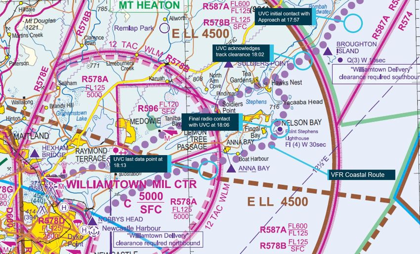
At 1755, the pilot made contact with Williamtown Tower, requesting clearance to track south via
the VFR coastal route (Figure 1). The pilot also requested a climb to a higher altitude, to take
advantage of more favourable winds. In response, the Williamtown Tower controller advised them
to contact Williamtown Approach (Approach) for clearance.
At 1757, the pilot of UVC contacted Approach and requested a clearance. At 1758, the Approach
controller identified UVC’s position as 7.4 km to the north-east of Broughton Island (Figure 1), and
advised the pilot they could operate at whatever altitude was required provided it was not below
2,400 ft. 4 The pilot responded with a request to operate between 3,000 and 3,500 ft. UVC was
cleared to track coastal southbound at a block altitude between 3,000 and 3,500 ft.
At 1759, following an inquiry from the Approach controller, the pilot advised that Bankstown was
the intended destination. At 1800, the pilot was advised that if any further track or altitude changes
were required, to inform Air Traffic Control (ATC) accordingly. While no response was required,
the pilot did not acknowledge the transmission.
Published last light for Anna Bay, NSW was 1801. At this time the controller again contacted UVC
to offer alternative tracking if required. The pilot responded requesting to remain on the eastern
2
Eastern Standard Time (EST): Coordinated Universal Time (UTC) +10 hours
3 Visual flight rules (VFR) are a set of regulations which allow a pilot to only operate an aircraft in weather conditions
generally clear enough to allow the pilot to see where the aircraft is going.
4
The lowest altitude that could be assigned for night operations due to terrain clearance requirements.
›1 ‹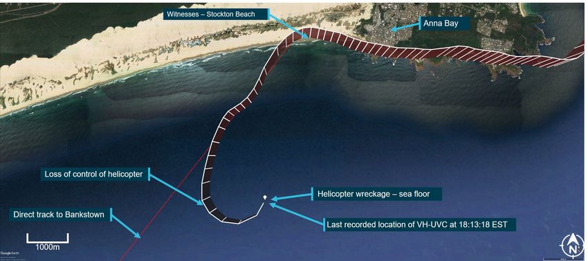
ATSB – AO-2019-050

side of the R578A Williamtown restricted area. The controller clarified this request and in
response, the pilot advised that if the track was not available, they would continue on the VFR
coastal route. The pilot was then cleared to track as required for Bankstown Airport. The track
clearance was acknowledged by the pilot at 1802.
Figure 1: Williamtown airspace map with VH-UVC’s position at various times

Source: Airservices Australia, annotated by the ATSB

A final text message from the passenger was received by the Bankstown operator at 1804
advising that UVC was approaching Williamtown.
At 1805, the Approach controller contacted the pilot to confirm that operations were normal,
having observed that UVC’s altitude had dropped to 2,700 ft. The pilot acknowledged the loss of
altitude, commenting on a wind gust affecting the helicopter. The controller responded by
providing clearance for the pilot to operate between 2,400 and 3,500 ft. This was acknowledged
by the pilot who also commented on the turbulent conditions that were being experienced. The
controller acknowledged the conditions and made a further offer of assistance should it be
required.
UVC was then observed on Williamtown ATC radar to make a left turn to the south, depart the
VFR coastal route and head offshore. Automatic Dependent Surveillance - Broadcast (ADS-B) 5
data supplied by Aireon, indicated that the helicopter’s position at the beginning of the turn, at
1811:23, was 2.3 km west-south-west of Anna Bay 6 (Figure 2).
The turn offshore was witnessed by two recreational fishers who were located on Stockton Beach,
about 2 km to the west of Birubi Point, Anna Bay. They described seeing a helicopter track
overhead in a westerly direction, then turn out to sea, heading in a south-westerly direction. They

5
    ADS-B is a system in which equipment on board an aircraft automatically broadcasts the precise location of the aircraft.
    The data can be used by other aircraft and air traffic control to identify the aircraft’s position and altitude without the
    need for radar.
6
    All distances with respect to Anna Bay are referenced from the intersection of Morna Point and Gan Roads, Anna Bay
    New South Wales.
                                                              ›2 ‹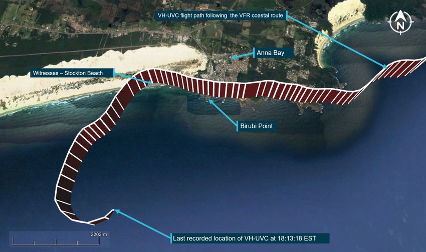
ATSB – AO-2019-050

reported that the helicopter sounded loud, and its lights were observed until it disappeared from
sight, following a turn to the east.
The helicopter continued to track offshore to the south-west for about 90 seconds, maintaining an
altitude of between 2,568 and 3,168 ft, before commencing a rapidly descending left turn. ADS-B
data showed that the aircraft commenced this descent from 2,968 ft at 1812:55 which was about
12 minutes after published last light. At 1813:12, a short, loud but indistinct transmission, that may
have originated from UVC was recorded by Williamtown ATC. The last Aireon ADS-B data point
identified the aircraft passing an altitude of 93 ft at 1813:18. UVC disappeared from the
Williamtown ATC radar display at 1813:26.
Figure 2: Flight path of VH-UVC following the VFR coastal route passing Anna Bay and
the turn offshore

Source: Google and ADS-B data (Aireon), annotated by the ATSB

Two attempts by the Approach controller to contact the pilot at 1813:17 and 1813:27 were
unsuccessful. The controller then broadcast advice to the pilot that surveillance identification had
been lost and to immediately check altitude. Further advice of the area’s QNH 7, the lowest safe
altitude in the area, and an instruction to climb immediately, were broadcast. The controller
followed that transmission with several more unsuccessful attempts to contact the pilot. There was
no response and at 1815 the Approach controller contacted the Australian Maritime Safety
Authority’s, Joint Rescue Coordination Centre and notified them of the missing helicopter.
The initial search for UVC, using a fixed wing aircraft and several rotary wing aircraft, was
hampered by poor weather and sea conditions. The search was concentrated in the vicinity of
reported oil slicks and floating wreckage several kilometres to the south west of Birubi Point. The
search was suspended after several days when the likelihood of locating survivors had passed.
An extended sea and aerial search for the helicopter was continued by the NSW police and later,
with assistance from the Royal Australian Navy. Wreckage from the destroyed helicopter was
located on 25 September 2019, 5.3 km to the south west of Anna Bay, in about 30 m of water.

7
    QNH: altimeter barometric pressure subscale setting used to indicate an aircraft’s height above mean sea level.

                                                                ›3 ‹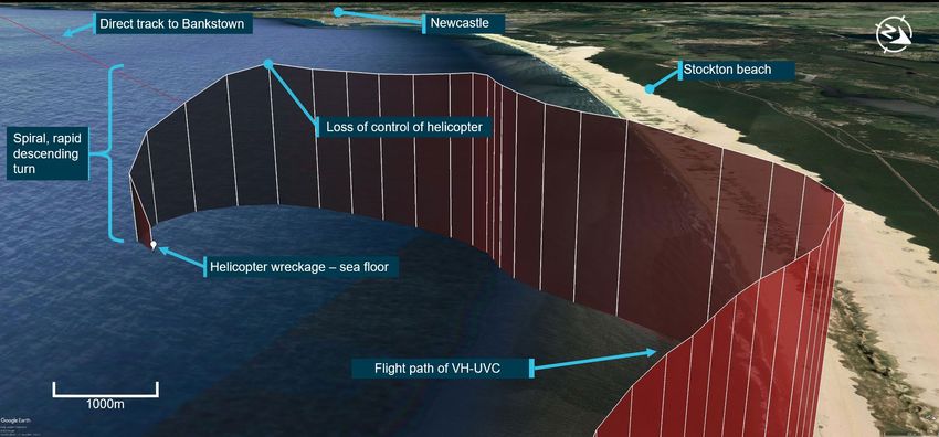
ATSB – AO-2019-050

Two of the five persons on board the helicopter were confirmed to have received fatal injuries. The
bodies of the pilot and two of the occupants were not found but they were presumed to have
similarly not survived the accident.

                                               ›4 ‹
ATSB – AO-2019-050
Context
Pilot information
The pilot held Private and Commercial Pilot licences (Helicopter) and was qualified to fly by day
under the Visual Flight Rules (VFR). The pilot also held a single-engine helicopter class rating and
a gas turbine engine design feature endorsement. The pilot last conducted a single-engine
helicopter flight review on 25 October 2018 that was valid until 31 October 2020. A Class 1
Aviation Medical Certificate issued by the Civil Aviation Safety Authority (CASA), valid until 26
April 2020, was also held.
The pilot’s logbook indicated a total of 1,440.5 hours total flying experience, of this about
103 hours were on the UH-1H. In the previous 90 days, 9 hours were accrued with 1.8 hours on
the UH-1H. A review of flying-related documents showed that the pilot:
• commenced flying on 9 September 2011
• completed his Private Pilot Licence (Helicopter) on 10 April 2013
• completed his low level (Helicopter) flying training on 13 June 2013
• completed his Commercial Pilot Licence (Helicopter) on 26 June 2015.
The pilot completed their endorsement on the UH-1H on 26 October 2018 and was appropriately
qualified to operate VH-UVC (UVC). The pilot was not qualified or trained to fly at night. At the
time of gaining their Private and Commercial Pilot Licences (Helicopter) there was no requirement
for night or instrument flight training. An examination of the pilot’s logbook found no evidence of
night flying or instrument flying experience.
Pilot’s medical history
The pilot was being treated for significant health issues and sought regular medical support from a
non-aviation medical specialist from January-March 2019. Following a break in treatment, the pilot
again visited the specialist on 3 September 2019. While being treated, the following medications
were prescribed:
• valdoxan
• olanzapine
• naltrexone
• diazepam
Valdoxan and olanzapine have the potential for producing a sedating side-effect, requiring
management of the dosage amount. During medical reviews with their specialist, the pilot did not
report feelings of sedation in the morning or during the day. The diazepam was prescribed three
days before the accident, with a planned review at a subsequent appointment.
A witness reported that in the week of the accident the pilot disclosed that they had slept for a full
day, waking briefly in the evening, then slept through to the following morning. No explanation was
offered as to what prompted this. The pilot’s treating specialist last saw the pilot on 3 September
2019 and was unaware of the reported sleep episode. The specialist’s opinion was sought on
possible reasons, and the ATSB’s assessment of their comments was that it was unlikely to have
been the result of any of the prescribed medicines taken at their specified dosages.
As the pilot’s body was not recovered following the accident, the ATSB was unable to gain any
further medical information from a post-mortem examination or toxicological assessment.
72-hour history
The ATSB was unable to gather sufficient information to complete a 72-hour history, primarily due
to the pilot living alone. However, in the 24-hour period prior to the accident, the pilot:
›5 ‹ATSB – AO-2019-050
• exchanged text messages with a family member around midnight
• accessed the National Aeronautical Information Processing System to gain location
briefings that included weather related information at 0200
• briefly met up with a family member around 0745 on the morning of the accident.
With the limited information available, it was not possible to determine, whether at the time of the
accident, the pilot was operating with a level of fatigue known to affect performance. However,
from the available history, the pilot had about five hours of sleep opportunity the night before the
accident.
Aviation medical certificates
A current medical certificate is required to exercise the privileges of a pilot licence. A Class 1
medical certificate is required to exercise the privileges of a commercial pilot licence and a Class 2
medical certificate is required for a private pilot licence.
When applying to renew a medical certificate, pilots are required to update their medical history by
providing details of medications they have taken or have been prescribed. Additionally, pilots are
required to provide information relating to any medical procedures, medical issues or symptoms
that required the input of a medical specialist.
On completion of an examination by a Designated Aviation Medical Examiner (DAME) a report is
submitted to the CASA to assess whether a medical certificate can be issued or whether further
information or tests are required.
In the course of renewing their medical certificates, the accident pilot did not disclose medical
conditions under treatment, or the medications that had been prescribed.
For the awareness of flight crews, CASA publicises a limited list of approved medications, 8 along
with a list of medications that are considered hazardous to aviation. Medications that assist sleep
are considered as hazardous. Medications that are considered as hazardous can only be used
with the express clearance of the CASA or a DAME.
The ATSB sought advice regarding the medications that had been prescribed to the pilot of UVC
from a subject matter expert (SME) in aviation medicine. The SME advised the ATSB that
diazepam, olanzapine and naltrexone:
Were absolutely incompatible with flying with respect to CASA guidelines, as were the conditions for
which they had been prescribed.
and for valdoxan:
(restrictions) would be imposed for conditions requiring valdoxan, but only after 1-3 months grounding
and then with a written clearance from a [treating specialist], DAME and treating GP. CASA would
require on-going medical audit and only a restricted medical certificate would be issued.
The SME further advised that, based on the pilot’s medical history and occurrence information,
medical incapacitation from a heart attack, seizure, other underlying condition or known
medications were unlikely to have contributed to the accident.
Aircraft information
General information
UVC was a Bell Helicopter Company UH-1H, S/No 5144, manufactured in the United States of
America in 1966. The UH-1H is a medium size, single engine utility helicopter with a two-bladed
main rotor system. Standard configuration included dual controls, seating capacity for 13 persons,
8
Available at www.casa.gov.au – aviation medicine - medication
›6 ‹ATSB – AO-2019-050
including two crew members, and skid type undercarriage. UVC was placed on the Australian Civil
Aircraft Register on 2 October 2018 and was issued with Special Certificate of Airworthiness No.
13L1817 in the Limited 9 category on 17 October 2018.
The Special Certificate of Airworthiness specified that the aircraft was to be operated:
• in accordance with the operating limitations contained within the approved Army Model UH-1H
Helicopter Operator’s Manual
• by day under the Visual Flight Rules unless the aircraft was appropriately equipped for night or
instrument flight.
Aircraft records
UVC’s Log Book Statement 10 specified that maintenance releases were to be issued for periods of
150 hours time-in-service or 12 months, whichever occurred earlier. Maintenance reference data
for UVC was the UH-1 series, military services Inspection Planning Guide from the Interagency
Committee for Aviation Policy (ICAP 11).
The maintenance release, current at the time of the accident, was issued on 16 October 2018 for
day VFR operations at an aircraft time in service of 6,693.0 hours.
The current maintenance release with flight hour information for UVC was not recovered from the
helicopter following the accident. An estimate of the aircraft time in service was derived from the
pilot’s logbook to determine UVC’s operating time since the issue of the maintenance release. It
was estimated that prior to departure from Archerfield, UVC’s total time in service was about
6790.0 hours.
At 6,743.0 airframe hours a 50-hour inspection was required, involving:
• visual inspections
• mounting hardware torque checks
• rotor drive train oil system maintenance.
Additionally, a voltage regulator inspection was required to be performed by 16 April 2019.
Maintenance history
Following arrival in Australia, the helicopter was assembled and refurbished. The refurbishment
included maintenance actions for the initial issue of the certificate of airworthiness, systems
checks and post-maintenance testing. Maintenance records indicated that on completion of the
refurbishment, flight testing that included dynamic balancing of the main rotor system and
confirmation of correct flight control stick forces was conducted. Additional and on-going
maintenance requirements were annotated on the maintenance release.
Prior to departure from Archerfield, a 10-hour/14-day inspection was performed, and a clearing
endorsement was entered on part 1 of the maintenance release. An image of the maintenance
release showing the clearing endorsement was provided to the ATSB.
The image also showed that the 50-hour inspection due at 6,743.0 hours, and the voltage
regulator inspection due on 16 April 2019, had not been endorsed on the maintenance release as
having been completed. An image of part 2 of the maintenance release, where maintenance can
9
Operational category assigned to ex-military (warbird), historical or replica aircraft under Part 132 of the Australian Civil
Aviation Safety Regulations
10
Log Book Statement - a document contained within an aircraft’s permanent records that identifies relevant aircraft
details and documents the aircraft’s maintenance program and maintenance release inspection information
11
ICAP: Interagency Committee for Aviation Policy established by the General Services Agency, United States of
America, for the effective acquisition, management and disposal of federally owned aircraft
›7 ‹ATSB – AO-2019-050
be certified, was not provided. The aircraft logbook did not contain details of maintenance activity
beyond UVC’s refurbishment and maintenance release issue on 16 October 2018.
The ATSB was unable to verify if the required maintenance had been performed as the aircraft’s
maintenance release was not recovered from the wreckage.
Aircraft systems
Flight control system
UVC was equipped with a hydraulically-assisted flight control system which could be operated by
either the pilot or co-pilot. The system included the cyclic and collective control systems, allowing
operator inputs to the main rotor system, and tail rotor pedals for control of the tail rotor.
With hydraulic assistance power removed, the pilot would experience higher than normal forces to
move the cockpit controls, and moderate feedback would be felt when the controls were moved.
However, full main and tail rotor system control would still be available and control movements
would result in a normal helicopter response.
Figure 3: Layout of Bell Helicopter Company UH-1H with major components labelled
Source: Bell Helicopter Company, annotated by the ATSB
Hydraulic system
The hydraulic system consists of a single hydraulic pump supplying pressure to the hydraulic
servo cylinders connected to mechanical linkages in the helicopter’s flight control system. When
the cockpit controls are moved, pressurised hydraulic fluid enters the cylinders reducing the force
for control movement.
In the event of a hydraulic system malfunction, feedback forces from the main rotor are prevented
by irreversible (check) valves in the hydraulic servo cylinders. This allows the pilot to continue
making the required control system inputs. In the event of a hydraulic power failure, the pilot
should land a soon as practicable in an area that will permit a run-on landing. 12
12
A manoeuvre that is used to transition from forward flight to a landing on the surface where a hover landing is not
possible or appropriate.
›8 ‹ATSB – AO-2019-050
Aircraft modifications
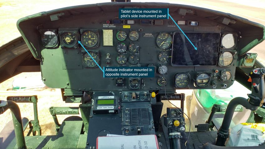
UVC was a standard UH-1H helicopter with no recorded airframe modifications, however a tablet
device (Figure 4) was mounted on the pilot’s side instrument panel. From reference to an image of
UVC’s cockpit and the UH-1H Operator’s Manual it was determined that the pilot’s side, attitude
indicator and directional gyro may have been removed to accommodate the device or were
obscured once the device was installed. A second attitude indicator was mounted in the left side
instrument panel.
To accommodate the tablet installation, the pilot’s airspeed and turn and slip indicators were
relocated to new positions below the tablet device. While the UH-1H Operator’s Manual did not
specify the instruments that were required for VFR flight, relocation of instruments was permitted.
Figure 4: VH-UVC instrument panel
Source: Niza Villanueva, annotated by the ATSB
UH-1H helicopter limitations
The Operator’s Manual for Army Model UH-1H helicopters, specified that intentional flight into
severe or extreme turbulence or into thunderstorms was prohibited. Other limitations for UVC
were a gross weight limitation of 4,309 kg, and a never exceed limit of 112 kt indicated airspeed.
This limiting airspeed varied slightly with aircraft gross weight and atmospheric conditions.
Wreckage information
Search for helicopter and wreckage field
A Royal Australian Navy vessel tasked to assist the search, located the helicopter wreckage field
about 3.5 km offshore, in about 30 metres of water. NSW police divers located parts from the
helicopter and provided the ATSB with a series of location coordinates from a GPS-enabled dive
camera. The positions of the helicopter parts were mapped to show their relative positions on the
ocean floor (Figure 5).
›9 ‹ATSB – AO-2019-050
Figure 5: Map showing relative positions of helicopter wreckage on the ocean floor
relative to UVC’s flight path
Source: Google using Aireon data for UVC flight path and NSW police supplied positions of wreckage items, annotated by the ATSB.
The heaviest items, including the main rotor system and the engine, were located within 10 metres
of each other. Other debris and parts of the cabin were also nearby. The tailboom was located
about 51 metres to the south-east of the engine’s position.
Helicopter wreckage
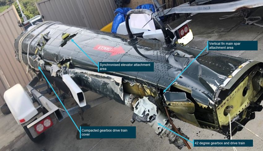
The engine, main rotor system and tailboom were identified in underwater imagery recorded by
the Royal Australian Navy during the search for the helicopter. The imagery showed that the
tailboom was missing the vertical fin, tail rotor gearbox, tail rotor, and the synchronised elevators
(Figure 3).
Imagery of the main rotor system showed both main rotor blades attached to the rotor head and
the transmission mast connected to the upper reduction gearbox section of the transmission
assembly. The lower section of the transmission assembly that included the mount casing and tail
rotor drive section was not identified.
One of the main rotor blades appeared to be largely straight with damage to the outboard section.
In contrast, the opposite blade was significantly damaged. The blade tip section was missing and
there was evidence of blade deformation in bending. The ‘D’ section leading edge main spar, was
visible and portions of the blade aerofoil section between the blade leading and trailing edges
were missing. It is likely that both blades were rotating when they struck the water.
The swashplate, main rotor system (Figure 3) and pitch control mechanism were also present.
Additionally:
• the transmission and main rotor blade system had detached from the fuselage during the
accident sequence
• there was no evidence of a flight control system fault
• significant disruption of other sections of the helicopter was evident
• the damage was consistent with a high-speed impact with water.
› 10 ‹ATSB – AO-2019-050
The engine was located on the ocean floor in the vicinity of the main rotor system and the cockpit
and cabin remains (Figure 5). The engine was intact, with the exception of the exhaust pipe. It
was not possible to determine the integrity of the engine, or its serviceability from available
imagery, however no obvious defects were identified.
Figure 6: Engine from VH-UVC located within the wreckage field
Source: NSW police, annotated by the ATSB.
Other helicopter parts that were identified included:
• remains of the cockpit area
• both cockpit seats
• fragments of cabin structure
• sections of the undercarriage
• items of portable refuelling equipment.
Other pieces of the helicopter were present however identification was limited by the clarity of the
water and some items had become partially buried by sand. On Monday 16 September 2019 a
member of the public provided NSW police with a small honeycomb panel. It had washed ashore
between Kingsley Beach and Little Kingsley Beach, located about 2 km to the south-east of Anna
Bay.
Two other pieces were found and reported to NSW police on 18 September 2019. They were also
of honeycomb construction (Figure 7) and were found at separate locations on Stockton Beach,
NSW. The construction and paint colour of the panels were similar to structural panels used in
UVC, however no features specifically linking the items to UVC were identified.
A portion of helicopter main rotor blade washed ashore at Blinky Beach on Lord Howe Island,
NSW and was reported to police on Friday 17 January 2020. The blade was constructed from an
aluminium composite material, measured 800 mm by 340 mm and was painted matt black. It bore
a sticker that read ‘bh Fort Worth Texas’, which identified the section as belonging to a Bell
Helicopter.
› 11 ‹ATSB – AO-2019-050
Figure 7: Items of honeycomb construction found on Stockton Beach, probably from
UVC
Source: NSW police
Tailboom assessment
UVC’s tailboom was retrieved by NSW police divers and made available to the ATSB for
examination. The tailboom (Figure 8), without the vertical fin, synchronised elevators, tail rotor
gearbox and tail rotor assembly (Figure 3), had separated at the fuselage rear bulkhead due to
overstress failure of the rear fuselage structure.
Figure 8: VH-UVC tailboom following recovery from the ocean floor
Source: NSW police, annotated by the ATSB
› 12 ‹ATSB – AO-2019-050
Internally, the remains of the synchronised elevator control system and the tail rotor pitch control
systems were present. Failures of the control tubes and cables were attributed to overstress.
Examination of the tailboom did not identify any pre-existing defects likely to have influenced the
accident sequence.
The tail rotor drive train from the rear fuselage tailboom junction to the 42° gearbox was also
present. Compression damage to the tailboom driveshaft cover was consistent with water impact.
Drive shaft coupling imprints were noted on the cover (Figure 9). The imprints were consistent
with the driveshaft not rotating at the time of impact. However, rotational damage signatures were
also present at either end of the recovered tail rotor drive train. Additionally, multiple contact marks
were evident on the side of the boom in the vicinity of the synchronised elevator attachment
points. Those marks were consistent with repeated movements of the elevators.
Figure 9: Tailboom driveshaft cover with inset showing driveshaft coupling imprints
Source: ATSB
Recorded data
Overview
The aircraft was fitted with a Mode S transponder that broadcast ADS-B data. This information
included the position and altitude of the aircraft and was received by Airservices Australia as well
as other third-party ADS-B receivers (Aireon and Flightradar24).
Two mobile devices with the OzRunways electronic flight bag application installed were on board.
The application provided the option for live flight tracking by transmitting the device’s position and
altitude. ADS-B and OzRunways data was obtained and analysed by the ATSB.
Both the Aireon and OzRunways data was compared and found to be consistent, however the
Aireon data has been used in this report as it provided higher fidelity for altitude information over
the final flight segment. The data was transmitted at five second intervals and a track line was
produced by joining each data point with a straight line. Variations between these data points were
not captured.
› 13 ‹ATSB – AO-2019-050
VH-UVC flight path
From Broughton Island UVC tracked past Yacaaba Head, Fingal Bay then Morna Point (Figure
10). Once past Anna Bay, the pilot commenced a left turn away from the coast, aligning with a
direct track to Bankstown (Figure 11 and 12). The turn and subsequent track were inside the
Williamtown military control zone area boundary. The helicopter tracked offshore to the south-west
for about 90 seconds before commencing a rapidly-descending, left turn followed by a collision
with the ocean surface.
Figure 10: Townships along the VFR coastal route once UVC passed Broughton Island
Source: Google using ADS-B data (Aireon), annotated by the ATSB
Figure 11: Overhead view of UVC flight path showing turn to seaward and spiral descent
Source: Google and ADS-B data (Aireon), annotated by the ATSB
› 14 ‹ATSB – AO-2019-050
Figure 12: Side view of UVC flight path showing turn to seaward and spiral descent
Image description: The flight path is provided for illustrative purposes. The altitudes as presented originate from raw data and have not
been corrected for atmospheric conditions.
Source: Google and ADS-B data (Aireon), annotated by the ATSB
The variation in UVC’s flight parameters over the final 30 minute period is presented in a graphical
format (Figure 13) with key events presented in an overhead view (Figure 14). The rate of change
of altitude and track, before and after last light, where the pilot appeared to be attempting to
maintaining a constant altitude, were averaged and compared. For the period after last light and
prior to the turn away from the coast:
• the average variations in altitude increased by a factor of 2 compared to daylight operation.
• excluding what appeared to be a deliberate turn by the pilot at about 1809, the average
variations in track increased by a factor of 3 compared to daylight operation.
› 15 ‹ATSB – AO-2019-050
Figure 13: UVC flight parameter variation over the final 30 minutes
Source: ADS-B data (Aireon) with ATSB analysis
Figure 14: UVC flight path from Broughton Island
Source: Google and ADS-B data (Aireon), annotated by the ATSB
› 16 ‹ATSB – AO-2019-050
Once past Anna Bay, UVC’s flight path from the turn to seaward to the spiral descending turn was
further examined. The flight path is presented in a graphical format in (Figure 15) with key aspects
noted below:
• at 1811:23, UVC commenced a left turn which continued until 1811:56, aligning with the
direct track to Bankstown Airport
• from 1811:27 to about 1812:24, the altitude increased by about 550 ft
• a right turn commenced at 1811:56, continuing until 1812:15. Ground speed decreased
during this time period
• a turn to the left commenced between 1812:15 and 1812:20
• from 1812:20 to 1812:24 the track changed to the left by about 21⁰
• from 1812:24 to 1812:50 there were ground speed and altitude changes, with a continuing
left turn
• from 1812:50 to 1812:55 the turn rate and altitude increased
• from 1812:55 there was a rapid loss of altitude and rapid changes in track and ground speed,
consistent with a loss of control. The average rate of descent after the loss of control was
calculated to be about 7,500 feet per minute, peaking at 11,636 feet per minute at 1813:18
• Based on wind speeds recorded at WLM it is estimated that in the last 14 seconds of the
descent, UVC’s VNE 13 limit was exceeded by up to 45 kt.
Figure 15: UVC flight parameter variation over the final 150 seconds of flight
Source: ADS-B data (Aireon) with ATSB analysis
13
VNE: Never-exceed speed.
› 17 ‹ATSB – AO-2019-050
Air traffic services
The pilot submitted a flight plan for the Archerfield to Coffs Harbour leg. A flight plan was not
submitted for the Coffs Harbour to Bankstown leg, however, there was also no requirement for
one.
The pilot’s first contact with Williamtown Air Traffic Control (WLM ATC) was a request for an
airways clearance at 1755. When issuing the requested clearance, the controller asked whether
UVC had a CAR174B exemption 14, which would allow UVC to operate at a lower minimum
altitude at night. On receiving no acknowledgement, the Approach (APP) controller advised the
pilot that 2,400 ft was the lowest altitude that could be offered. There was no indication provided to
the controller in the radio exchange that the pilot was not qualified to continue the flight after last
light.
At 1800:27 and 1800:56 WLM ATC offered the pilot of UVC alternate tracking and at 1801:41
cleared the pilot to manoeuvre as required for tracking to Bankstown. At 1805:41, the APP
controller issued a safety alert advising the pilot to ‘check altitude’ when UVC dropped to 2,700 ft,
which was below the clearance altitude of 3,000 ft. The pilot reported turbulent conditions and in
response the controller re-cleared the pilot to operate from the lowest safe altitude of 2,400 ft to
3,500 ft. At 1806:09 the controller requested the pilot to advise if anything further was needed.
The turn offshore at 1811:23 was observed on WLM radar. An indistinct transmission, which was
assumed by ATC to be from UVC, was heard at 1813:12, about 17 seconds after the loss of
control had likely occurred (Figure 15). UVC was observed on radar in a rapid descent from about
2,900 ft, disappearing from WLM radar coverage at 1813:26. By 1813:27, the APP controller had
alerted the Tower controller of the unfolding situation, and made two standard radio calls seeking
a response from UVC.
A detailed alert to UVC specifying that identification had been lost, and a low altitude warning to
check altitude, was made at 1813:32 by the APP controller. The alert also included the area
barometric pressure, the lowest safe altitude, and an instruction to initiate an immediate climb.
There was no response from UVC and a further five radio calls were made to contact the pilot by
WLM ATC controllers.
At 1824:13, in response to a request from the APP controller, the pilot from one of the WLM
departing aircraft called UVC on the 121.5 emergency frequency and reported that no response
was received.
The ATSB engaged the services of an ATC subject matter expert (SME) to review the controller’s
interaction with the pilot of UVC. The SME concluded that:
The actions of WLM ATC throughout the flight of UVC were in accordance with the published rules
and procedures for an aircraft operating Night VFR. In addition, WLM ATC offered alternative and
flexible clearances to meet the needs of the pilot in command.
Operational information
Flight endurance
CASA regulatory requirements specify that pilots of helicopters conducting private flights under
the VFR are to carry a fixed fuel reserve of 20 minutes flight time. The pilot in command is
required to ensure that this fuel reserve remains unused on landing unless an emergency is
declared. Pilots are also required to refer to operational information such as current weather
reports and forecasts for the route to be flown and to plan the flight using that information.
14
An exemption to Civil Aviation Regulation CAR174B that places minimum safe altitude restrictions upon an aircraft
operating under the night VFR.
› 18 ‹ATSB – AO-2019-050
The witness at Coffs Harbour noted that prior to departure, the helicopter’s fuel tank had been
filled to overflowing and a quantity of fuel remained in the 205 litre drum. The UH-1H operations
manual stated that the useable fuel quantity was 781.6 litres or 1,362 lbs of fuel. UVC’s fixed fuel
reserve requirement was calculated to be 195 lbs of fuel.
The distance from Coffs Harbour to Bankstown via a coastal route to Anna Bay and then direct
track to Bankstown, was calculated to be about 250 nautical miles. A flight in nil wind conditions,
allowing for climb and descent, at an indicated airspeed of 95 kt would have required about
1,570 lbs of fuel. The fuel quantity required for UVC to transit from Coffs Harbour to Bankstown
using forecast winds was calculated to be about 1,265 lbs.
Provided the forecast conditions had continued, the pilot of UVC would have required an
intermediate refuelling stop or to declare a fuel emergency prior to arrival at Bankstown. Any
holding or diversion would likely have required a landing before Bankstown to prevent airborne
fuel exhaustion.
Pilot access to weather information
The pilot accessed the National Aeronautical Information Processing System (NAIPS) using the
OzRunways electronic flight bag application at 0200 and 0202 on 6 September 2019. Requests
were made for location briefings and NOTAM 15 information for Archerfield, Coffs Harbour and
Sydney.
A forecast for the intended route was not requested, nor were Head Office NOTAMs or
SIGMETs. 16 The pilot did not access further weather information through NAIPS. However, it
could not be established whether the pilot, or one of the passengers, sourced further updates
enroute via other means.
Night VFR (Helicopter) qualification and training
For VFR flights conducted at night, a Night Visual Flight Rules (NVFR) rating and helicopter NVFR
endorsement are required. Training for the rating and endorsement covers theory and practise in
the areas of basic instrument flight, navigation aid training and procedures in the event of
abnormal situations. In addition, human factors and non-technical skills awareness and
application, specific to the night flying environment are covered.
A minimum of 10 hours night flying experience is necessary, of which at least five hours are
required to be in a helicopter or approved flight simulation training device. These night hours must
include dual flight, solo night circuits, and cross-country flights. Three hours of dual instrument
time in a helicopter or approved flight simulation training device is also required.
CASA regulatory requirements specify that a pilot who does not hold a NVFR rating, or instrument
rating, is not permitted to depart on a flight before first light or after last light, and is also not
permitted to depart unless the estimated time of arrival at the destination is at least ten minutes
before last light.
Decision making
Flight under the VFR requires minimum conditions of visibility and distance from cloud. Variation
from the expected weather conditions enroute may not enable a pilot to reach the planned
destination under this ruleset. That, in turn, will require a timely decision to land or divert when
15
Notice to Airmen (NOTAM): NOTAMs provide information that is of direct, and often immediate, operational
significance.
16
Significant meteorological information (SIGMET): a weather advisory service that provides the location, extent,
expected movement and change in intensity of potentially hazardous (significant) or extreme meteorological conditions
that are dangerous to most aircraft, such as thunderstorms or severe turbulence.
› 19 ‹ATSB – AO-2019-050
things are not going to plan. However, the human tendency to continue with a course of action is
documented in various research studies.
The American Psychological Association defines plan-continuation bias as:
‘The tendency of people to continue with an original course of action that is no longer viable’. An
example would be an airline pilot who unexpectedly encounters bad weather at the scheduled
destination but decides to land anyway rather than divert to another location. Plan-continuation bias
tends to be particularly strong towards the end of the activity and has been theorized to result from the
interaction of such factors as cognitive load, task demands, and social influences.
Errors associated with plan-continuation have been recognised in the analysis of a number of
aircraft accidents previously (NTSB, 1994; Batt and O’Hare, 2005; Dismukes, Berman and
Loukopoulos, 2007).
In the ATSB research investigation report B2005/0127, addressing general aviation pilot
behaviours in the face of adverse weather, Batt and O’Hare (2005) identified that the halfway point
of a flight may feel like a psychological ‘turning point’ for pilots.
The focus of the pilot’s thoughts and attention will shift gradually from the point of departure to the
planned destination…as the flight progressed, the chances of a VFR into IMC encounter increased
until they reached a maximum of 27.6% during the final 20% of the flight distance. This pattern
suggests that an increasing tendency on the part of pilots to ‘press on’ as they near their goal.
Options available to day VFR pilot’s experiencing reduced visual cues include contacting air traffic
control for assistance or conducting a precautionary landing. The ATSB’s ‘Don’t push it, LAND It’
safety messaging, jointly developed and supported by the Civil Aviation Safety Authority and the
Australian Helicopter Industry Association, encourages helicopter pilots to exercise this option.
Weight and Balance
Weight and balance information was derived from maintenance records, witness statements and
images provided to the ATSB. Additionally, estimated and known weights of the pilot, passengers,
baggage, equipment and fuel on board were used to calculate UVC’s weight and centre of gravity.
It was estimated that the weight of UVC on departure from Coffs Harbour was 3,808 kg, which
was below the Operator’s Manual gross weight limit of 4,309 kg.
The occupant seating positions were established from information provided by witness and from
on-board images that occupants exchanged with ground-based parties following their departure
from Coffs Harbour. UVC’s longitudinal and lateral balance was found to be within limits from
Coffs Harbour to Anna Bay.
Helicopter – basic operational equipment for flight under the night VFR
In addition to the equipment requirements for day VFR operations, Civil Aviation Order,
CAO 20.18 specifies that a helicopter may only be operated under the night VFR, if it is equipped
with instruments that include an attitude indicator and a heading indicator (directional gyroscope).
Further, for night VFR flights conducted over land or water where the helicopter’s attitude cannot
be maintained by the use of external visual surface cues from lights on the ground or celestial
illumination, a helicopter is to be:
• equipped with an approved automatic pilot or automatic stabilisation system, or
• operated by a qualified two pilot crew, each with access to the flight controls.
› 20 ‹ATSB – AO-2019-050
Helicopter emergency procedures
The Operator’s Manual for Army Model UH-1H helicopters provides guidance for pilots in the
event of system malfunctions or loss of function. In the event of a partial power loss, or if the
engine is no longer operating (Figure 16), an auto rotational descent 17 and landing is required.
Likewise, the pilot would initiate an auto rotational descent in response to:
• a drive train or tail rotor failure
• an engine to transmission main drive shaft failure
• a transmission free wheel unit disengagement.
Figure 16: Airflow through the main rotor system during an auto rotational descent
Image description: During an autorotation, the upward flow of relative wind permits the main rotor blades to rotate
at their normal speed.
Source: FAA Helicopter Flying Handbook
The descent is typically conducted at a specified forward airspeed for the helicopter type and
characterised as a controlled descent. For the UH-1H helicopter a typical auto rotational rate of
descent is about:
• 1,600 feet per minute with an indicated airspeed of 52 kt for minimum rate of descent, or
• 2,060 feet per minute with an indicated airspeed of 82 kt for maximum glide distance.
A loss of tail rotor control or drive to the tail rotor, is manageable provided adequate airspeed is
maintained, as directional stability will be provided by the helicopter’s vertical fin. The UH-1H
helicopter requires airspeeds above 30-40 kt to maintain directional control with a loss of tail rotor
drive. Other tail rotor malfunctions, including stuck pedals (fixed tail rotor pitch settings), require
40-70 kt airspeed be maintained.
When performing an auto rotational descent to a suitable landing site, a pilot has a choice in the
angle of descent, varying from vertical to maximum horizontal range. Pilots are trained to perform
auto rotational descents and auto rotational capability is a certification requirement for helicopters.
17
An auto-rotational descent is a power off manoeuvre in which the engine is disengaged from the main rotor system and
the rotor blades are driven solely by the upward flow of air through the main rotor.
› 21 ‹ATSB – AO-2019-050
Meteorological information
Forecast weather
Graphical Area Forecast (GAF)
The flight from Coffs Harbour to Bankstown occurred within the Graphical Area Forecast 18 New
South Wales – East that was valid from 1500 to 2100. Forecast conditions included:
• average conditions of greater than 10 km visibility with areas of scattered 19 cumulus and
stratocumulus cloud at altitudes between 4,000 and 8,000 ft
• widespread blowing dust reducing visibility to 5,000 m
• scattered showers of rain reducing visibility to 4,000 m with associated scattered cumulus and
stratocumulus cloud from 3,000 to 5,000 ft and broken cumulus and stratocumulus cloud from
5,000 to above 10,000 ft
• isolated smoke over the land reducing visibility to 4,000 m and isolated heavy smoke over the
land north of Taree reducing visibility to 2,000 m
• isolated thunderstorms over the sea reducing visibility to 3,000m with associated isolated
cumulonimbus clouds from 3,000 to above 10,000 ft
• moderate mountain wave activity forecast above 4,000 ft
• severe turbulence forecast below 10,000 ft with moderate turbulence north of Taree
The GAF also noted that moderate turbulence 20 is implied in cumulus, stratocumulus and
altocumulus cloud and severe turbulence 21 is implied in cumulonimbus cloud.
Significant Meteorological Information Advisory (SIGMET)
The Bureau of Meteorology (BoM) issued a Significant Meteorological Information Advisory at
1436 for severe turbulence below 10,000 ft valid from 1500 to 1900. The area affected by the
SIGMET covered the entire flight from Archerfield to Bankstown.
Grid Point Wind and Temperature
The Grid Point Wind and Temperature forecast valid at the time of the flight indicated the average
wind south of Coffs Harbour was 25 kt from the north-north-west at 2,000 ft.
Mean Sea Level Pressure chart
The Mean Sea Level Pressure chart showed a trough and frontal system approaching the
Williamtown area on the afternoon of the flight. These systems were moving west to east and had
an associated tight pressure gradient. 22
18
Graphical Area Forecast (GAF) provides information on weather, cloud, visibility, icing, turbulence and freezing level in
a graphical layout with supporting text. These are produced for 10 areas across Australia, broadly State-based.
19
Scattered cloud is defined as cloud totalling 3 to 4 OKTAS, meaning 3 to 4 eights of the sky obscured by cloud.
20
Moderate turbulence. There may be moderate changes in aircraft attitude and/or altitude, but the aircraft remains under
positive control at all times – usually, small variations in air speed – changes in accelerometer readings of 0.5g to 1.0g
at the aircraft’s centre of gravity – difficulty in walking – occupants feel a strain against seat belts – loose objects move
about.
21
Severe turbulence. Abrupt changes in aircraft attitude and/or altitude – aircraft may be out of control for short periods –
usually, large variations in air speed – changes in accelerometer readings greater than 1.0g at the aircraft’s centre of
gravity – occupants are forced violently against seat belts – loose objects are tossed about.
22
The pressure gradient is indicated by the proximity of isobars (lines of constant pressure) on a surface weather map.
When the lines are close together a large (tight) pressure gradient exists, which can indicate relatively higher wind
speeds.
› 22 ‹You can also read