Mammoth Lakes Trail System 2020 - AWS
←
→
Page content transcription
If your browser does not render page correctly, please read the page content below
Mammoth Lakes Trail
System 2020
Adaptation

Joel Rathje   January 12, 2021

The beginning of 2020 was off to a "normal" start with winter
trails being groomed in Shady Rest, new sign designs were
taking shape, and our Trail Crew was gearing up for another
productive season of work. Then, we all entered into a time of
adaptation due to changing conditions with COVID19. Our
meetings became virtual in March 2020, and our team
implemented new best practices to be able to work in the field
safely. 2020 was a year of new challenges and opportunities
for a creative team of individuals working as part of the
Mammoth Lakes Trail System.
Comet Neowise over the San Joaquin Ridge

Planning

Lakes Basin Connector Trails
This project is currently in environmental review (NEPA) and
is expected to be shovel ready this summer (2021). New,
sustainable USFS system trails will be constructed to replace
user created trails that are not sustainable or properly
accessible. The multi-use, non-motorized trails will connect
Lake Mamie with Horseshoe Lake and Twin Lakes. The Lakes
Basin Special Study prescribed these concepts in 2011.
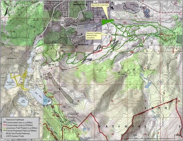
Sherwins Meadow Trails
The Sherwins Area Recreation Plan 2009 was adopted as part
of the Trail System Master Plan in 2011 and the Sherwins
Working Group prescribed many trail concepts in 2009. The
concepts have been proven out on the ground and trail
corridors are ready for environmental analysis. Some
resource analysis has been completed and more will be
needed for the project to be shovel ready.
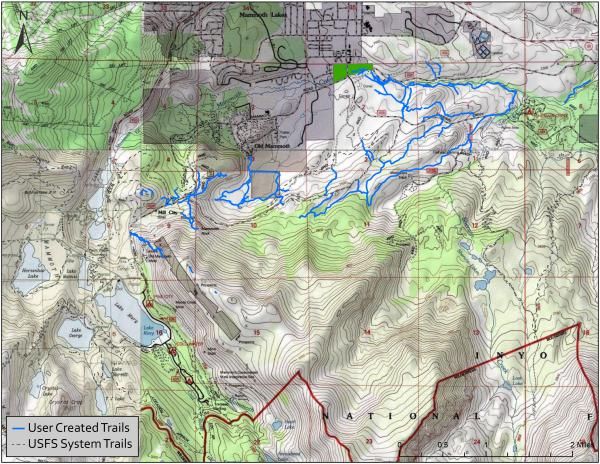
User Created Trails in the Sherwins

Shady Rest/Inyo Craters
•   Planning and environmental review (NEPA/CEQA) for the
    Shady Rest/Inyo Craters region in order to optimize
    existing OHV trail facilities and to consider expanding
    opportunities for OHV and nonmotorized trails (north of
    the town of Mammoth Lakes). This area lies within
    the Mammoth District of the Inyo National Forest (INF) and
    has the support of the District Ranger. This planning effort
    will enhance the existing OHV trail network by building
    upon existing infrastructure. Funds from the OHV program
    would be used for proper planning of new OHV trail
    facilities and to provide a more enjoyable and safer
    experience for OHV users including motorcycles, quads, e-
    bikes, side by sides and 4X4s. This effort will also
    potentially provide better access for camping, fishing,
    swimming, birding, hiking, trail running, horseback riding
    and mountain biking. In fall of 2018, the MLTS Team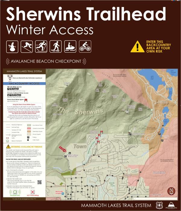
submitted an application for a 3 year planning grant to
              the California State Off-Highway Motor Vehicle Recreation
              Division. The grant has been awarded for $155,485. MLTS
              staff has completed ground work for over 20 miles of trail
              corridor so far.

Esri, NASA, NGA, USGS | U.S. Fish and Wildlife Service, Nevada Fish and Wildlife Office |…   Powered by Esri
                                       SRIC Planning Interactive Map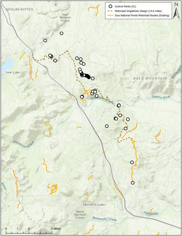
Trail Corridor Designed in Summer 2020 East of HWY 395
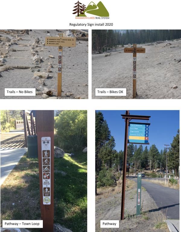
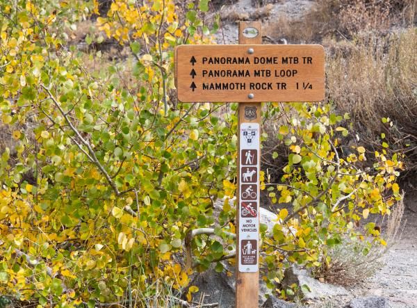
The Creek Fire and the Mammoth Crest

Signage and Wayfinding

Regulatory Signage
The need for regulatory signage was identified as part of the
Trail System Master Plan effort and was prioritized in 2020.
The custom signs were approved by the Town of Mammoth
lakes Recreation Commission, Mammoth Trails Committee,
and the Mammoth District of Inyo National Forest. The signs
are installed at entrance points to the trail system to make
trail users aware of what types of activities are allowed on
certain trails and pathways.
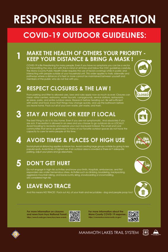
New Multi-Use, Non-motorized Regulatory Sign

Responsible Recreation
A part of our adaptation for 2020 involved creating temporary
signage to help trail users understand how to be safe while
recreating outside in Mammoth Lakes.
Sherwins Access and Egress Signs for Winter
Recreation
Our Sherwins Access/Egress signs are getting an update this
winter with added information for people. Now we need more
snow!
Trail Maintenance

Interactive Maintenance Map
During the 2020 season, the MLTS Trail Crew was able to
accomplish many great projects and improve the condition of
the trail system for trail users. We constructed a 1/2 mile
reroute of the Mammoth Rock Trail, a 1/2 mile reroute of the
Mountain View Trail, installed a new bridge on the Horseshoe
Lake Loop, and we removed hundreds of hazard trees and
fallen trees from system trail facilities. You can use the map
below to explore the different projects. Photos are attached
inside of the text boxes that appear when you click on
features on the map.
Mono County, Bureau of Land Management, Esri, HERE, Garmin, INCREMENT P, USGS, …   Powered by Esri
                                        Maintenance 2020

         Mammoth Rock Trail Reroute
This is a 1/2 Mile Reroute to Improve Sustainability and Flow on the lower Mammoth
Rock Trail
Mountain View Trail RerouteThis is a 1/2 Mile Reroute to Improve Sustainability and Flow for Trail Users
Finished Reroute
Constructing a Causeway to Prevent the Trail from Washing Out
We Constructed a New Bridge on Mountain View Trail also
A Very Large Tree Fell Across Mountain View Trail

  We are Grateful for our Cal Fire Partnership!
Horseshoe Lake Bridge #2
With another generous donation from the Langston Family
Trust, we were able to construct a new bridge for people to
use on the Horseshoe Lake Loop. The project was completed
in July, 2020 and will provide a safe crossing for many years to
come.

                          Finished Bridge
Bridge Under Construction
Bridge Under Construction

       Thank you!
Stewardship Trail Host - Community Host In winter of 2019, the MLTS Trail Host pilot program was initiated. The program is prescribed in the Trail System Master Plan as a way to help trail users have fun safely by providing information with human interaction. As 2020 moved from winter to spring, visitation and trail use increased. The need for hosts became more apparent and the program grew. During the summer of 2020, hosts collected data with a custom application, provided information to visitors, cleaned up litter, and generated reports. Now, we have a staff of 10 hosts that provide a presence in the community and out on the trails. We expect to be busy in the coming weeks and months as people seek outdoor adventure.
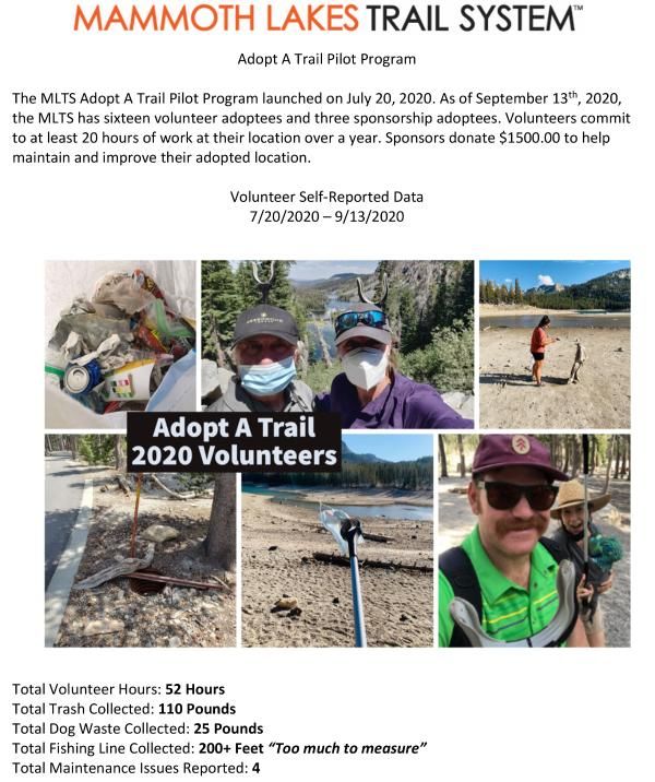
Number of Interactions with People

Adopt-A-Trail
The Mammoth Lakes Trail System has partnered with
Mammoth Lakes Recreation to implement a program for
people to "adopt" trails, facilities, and lakes to keep things
clean and well maintained. So far, the effort is successful with
many people participating as sponsors and volunteers.
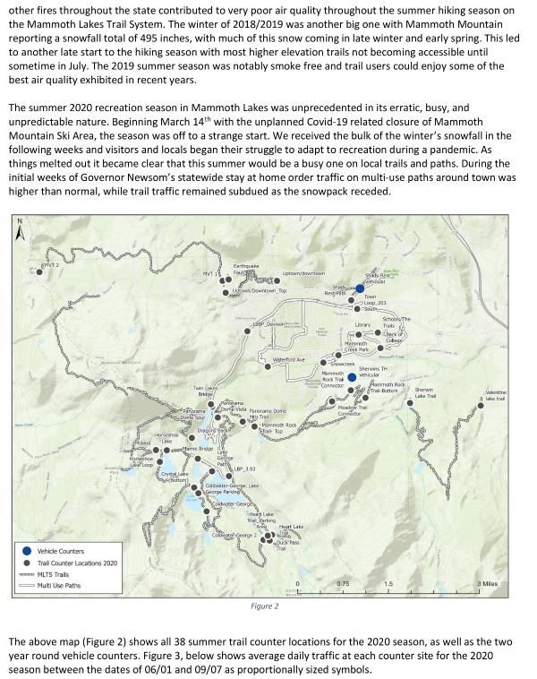
Mono Lake and Comet Neowise

Mammoth Lakes Trail System Data
Lake Mamie, the Comet Neowise, and a Meteor

Thank You!
Powered by ArcGIS StoryMaps
You can also read