Managing flood risk in the Hawkesbury - Nepean Valley
←
→
Page content transcription
If your browser does not render page correctly, please read the page content below
Managing flood risk in the
Hawkesbury – Nepean Valley
A report on the alternative flood management measures
to raising Warragamba Dam wall.

September 2018

Associate Professor Jamie Pittock

Fenner School of Environment & Society
The Australian National University.

                                                        1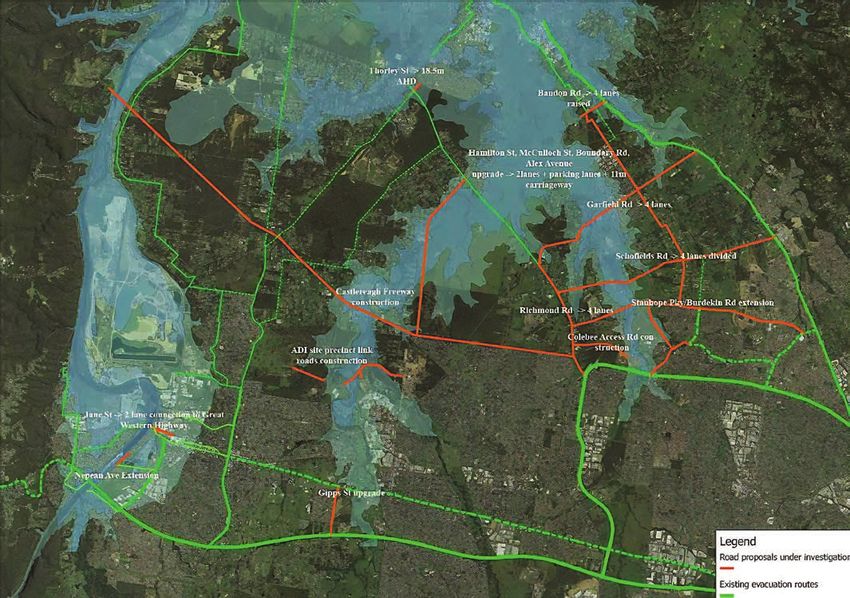
Dr Jamie Pittock (BSc, Monash; PhD, ANU) is
                               an Associate Professor in the Fenner School
                               of Environment and Society at The Australian
                               National University. He is also Director of
                               International Programs for the UNESCO
                               Chair in Water at ANU. Jamie worked for
                               environmental organisations in Australia and
                               internationally from 1989-2007, including
                               as Director of WWF’s Global Freshwater
                               Programme from 2001-2007. His research from
                               2007 has focussed on better governance of
                               the interlinked issues of water management,
                               energy and food supply, responding to climate
                               change and conserving biological diversity.
                               Jamie directs research programs on irrigation
                               in Africa, hydropower and food production
                               in the Mekong region, and sustainable water
                               management in the Murray-Darling Basin. He
is a member of the Wentworth Group of Concerned Scientists, the board of
Water Stewardship Asia-Pacific, and is a scientific adviser to WWF Australia.
Dr Pittock teaches courses on environment and society as well as on climate
change adaptation.

This report was prepared for the Colong Foundation for Wilderness.

2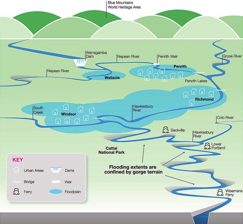
Flood risk in the Hawkesbury-Nepean floodplain
        The Hawkesbury-Nepean Valley is particularly prone to flooding as it is naturally
        constricted in two places that, in conditions of severe rainfall, results in floodwaters
        backing up and inundating floodplains in north-west Sydney. During large flood events
        there is a risk of roads being inundated by floodwaters before residential areas are
        properly evacuated.

        Flood risk has been exacerbated by local councils and the NSW Government approving
        housing developments on low lying lands over several decades. Unfortunately, flood
        risk is likely to worsen given NSW Government plans to dramatically expand the number
        of people living on the floodplain in north-west Sydney, combined with increased
        frequency of severe storm events due to climate change.

Figure 1. The Hawkesbury-Nepean floodplain (Infrastructure NSW Flood Factsheet, February 2018).

                                                                                                  3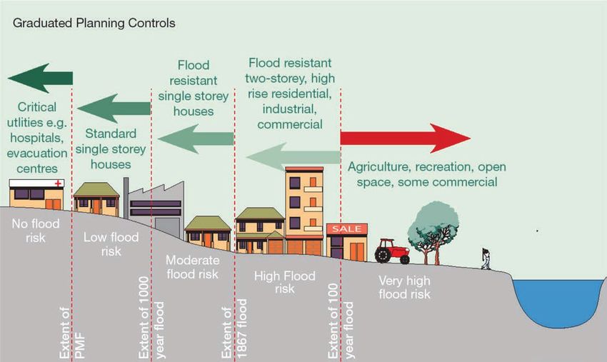
NSW Government response
The NSW Government has prepared a Hawkesbury – Nepean Valley Flood Risk
Management Strategy (Infrastructure NSW 2017). This strategy does not appear to
have benefitted from any independent expertise, nor is there any evidence of scientific
peer review. The strategy focuses on infrastructure options that were evaluated by
means of a narrowly framed cost-benefit analysis.

The strategy discards a number of response options before focusing on a proposal
to spend $690 million to raise Warragamba Dam wall by 14 metres to provide 995
gigalitres of air space to store flood waters originating upstream of Warragamba Dam
(Infrastructure NSW 2017). This proposal would result in flooding of up to 4,700 hectares
of the Blue Mountains National Parks and World Heritage Area, including 65 km of
wilderness watercourses, populations of 48 threatened species, as well as numerous
sites of cultural significance to the Gundungurra people (Colong Foundation for
Wilderness 2018).

The Hawkesbury – Nepean Valley Flood Risk Management Strategy concludes that
raising the dam is the most cost-effective method of managing flood risk by applying a
very narrow economic assessment to the project. For each flood risk reduction option,
the Infrastructure NSW assessment converts lack of vehicles evacuated into projected
deaths of people, turning these deaths into a monetary value, then adding property
losses to estimate the cost of flood damage. This is then compared to the cost of
each intervention, such as raising Warragamba Dam wall. Their calculations exclude
any additional benefits of alternative risk management measures. For example, in
considering the $950 million costs of upgrading roads to allow residents to evacuate at
higher flood levels, none of the other benefits of an improved road system appear to
have been considered, such as increased road safety and faster travel times. The cost
benefit analysis also excludes any estimate on the economic benefits of conserving
the Blue Mountains National Park and World Heritage Area upstream of the proposed
raised dam.

The NSW Government’s strategy is constrained by two overriding policy decisions,
namely that (i) it will not reduce the 5,000 houses on the most flood-prone lands, and
that (ii) it will allow an additional 134,000 people to settle in harm’s way on the floodplain
over the next 30 years (Infrastructure NSW 2017). The flaws in such a policy were seen
during the 2011 Brisbane floods. One of the reason for the severe flood damages
during the Brisbane floods were previous state and local government decisions to
allow housing development on high-risk areas of the Brisbane River floodplain, falsely
believing Wivenhoe Dam had ‘flood-proofed’ the valley (Cook 2017).

4

5
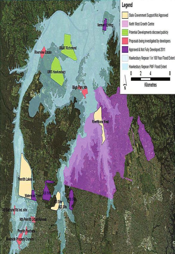
Figure 2. Proposed development areas overlaid with flood extend on western Sydney floodplains (Infrastructure NSW, Molino Stewart 2012a).
Importantly, no configuration of Warragamba Dam will prevent flooding in the
                                                         Hawkesbury-Nepean Valley. Since the dam’s construction in 1960, contribution of the
                                                         Warragamba catchment to major flooding events has ranged from 73% to 42%. An
                                                         average of 45% of floodwaters originate from catchment areas that are not upstream
                                                         of Warragamba Dam (NSW SES 2015). This means that even if a raised Warragamba
                                                         Dam was to hold back some flood waters, other catchments could still cause significant
                                                         flooding in the valley. In fact, flood waters from the Grose River alone can cause
                                                         moderate to major flooding of Richmond in the lower Hawkesbury (AWACS 1997).

                                                         Further, flood mitigation dams tend to ‘control’ only small and medium sized floods
                                                         from upstream catchments. In large flood events, once a dam is full, operators have no
                                                         choice but to spill the water from the dam. This was seen in the case of Queensland’s
                                                         Wivenhoe Dam which was kept half full to provide 1,450 billion litres of flood mitigation
                                                         airspace. The airspace was not enough to prevent extensive damage to Brisbane
                                                         when the dam waters were released in the January 2011 floods. Water released from
                                                         the dam was ruled as the “principal immediate cause” of the floods by the Insurance
                                                         Council of Australia (2011), which affected over 200,000 people and cost insurers $2.55
                                                         billion (van den Honert & McAneney 2011).
                                                         While a bigger flood control airspace in a dam may delay a flood peak, the captured
                                                         water takes longer to release from the dam, and so prolonging flood durations in
                                                         downstream areas. It would appear that prolonged downstream flooding resulting
                                                         from the raised dam has not been considered in the Infrastructure NSW flood strategy.

                                                      100%
 Sub-catchment contributions to flooding at Windsor

                                                      90%
                                                                                                                                                                        27%
                                                                  38%                              35%
                                                      80%
                                                                                  51%                               52%                                50%
                                                      70%                                                                             58%

                                                      60%

                                                      50%

                                                      40%
                                                                                                                                                                        73%
                                                                  62%                              65%
                                                      30%
                                                                                  49%                               48%                                50%
                                                      20%                                                                            42%

                                                      10%

                                                       0%
                                                             Novemeber 1961 June 1964 flood   June 1975 flood March 1978 flood August 1986 flood April 1988 flood August 1990 flood
                                                                 flood
                                                                                               Warragamba         Other catchments

Figure 3. Sub-catchment contributions to flooding at Windsor from recent floods (NSW Office of Water 2014).

                                                         6
Alternative options – a different vision
There are several alternative options that the NSW Strategy either does not adequately
consider or does not consider at all. Four key alternative options are discussed below.
1. Provide alternative flood storage in Warragamba Dam.
Lowering the full storage level of Warragamba Dam by 12 metres would free 795
billion litres of airspace for flood control. Further, lowering the full storage level would
have no upstream environmental impacts and can be implemented immediately.
This option was briefly mentioned as part of the Hawkesbury – Nepean Valley Flood
Risk Management Strategy but dismissed on the grounds that it would compromise
Sydney’s water security (Infrastructure NSW 2017). Independent, peer reviewed
research by the University of Technology Sydney has examined this option and shown
that coupled with use of current and new desalination plants, lowering the FSL could
be more cost effective than raising the Warragamba Dam wall (Turner et al. 2016). The
University of Technology modelling found that this approach not only provides some
level of flood mitigation, but also enhances Sydney’s water security. Feasibly and cost
benefit analysis research has also been undertaken by the University of Sydney on this
option (Paton 2014), as well as receiving support from UNSW water specialist Assoc.
Prof Stuart Khan (2012).
2. Stop putting people in harm’s way.
The state government is proposing to allow a further 134,000 residents to join the 70,000
existing residents on the floodplain over the next 30 years (Infrastructure NSW 2017;
Molino Stewart 2012a). As discussed above, no dam can stop the largest of floods, so
this proposal will put more people in harm’s way regardless of whether the dam wall is
raised. Infrastructure NSW consultants have stated that over 16,000 residential lots are
currently unable to be developed “due to flooding constraints” (Molino Stewart 2012b).
These lots are located on flood-islands that are unable to be properly evacuated
during flood events (Molino Stewart 2012b). The NSW Government’s strategy states
that it will permit development on land immediately above the 1:100 flood level. In the
United States, a minimum 1:500 year threshold is now widely used (Wenger et al. 2012),
whereas in the Netherlands they have adopted a 1:1,250 year flood return threshold
(Wenger et al. 2013). The NSW Government should impose a safer planning standard
on local governments that is in line with the rest of the western world. Doing so would
save billions of dollars in future flood damages and dramatically reduce the risk to life
that floods pose.
Changes to flood planning limits have already been put forward in the Land Use
Guidelines prepared for the Hawkesbury-Nepean Floodplain Management Steering
Committee. These guidelines highlighted that more comprehensive floodplain risk
management measures are required, rather than a single 1:100 flood planning limit
that is currently applies (HNFMSC 2006). This is not to say that the Hawkesbury-Nepean
floodplains should be undeveloped. These guidelines describe the need to develop
‘graduated planning controls’, which allow for maximum use of the floodplain, while
ensuring that risk to property and life is minimised (HNFMSC, 2006).
7Figure 4. An example of distribution of Land Uses on the Floodplain to reduce risk (HNFMSC 2006).
3. Improve evacuation routes.
Previous government investigations into flood mitigation strategies have found that
effective evacuation is the only measure that guarantees a reduced risk to life in
the Hawkesbury-Nepean Valley (Infrastructure NSW 2017). Given the multitude of
catchments from which floodwaters are sourced, a $950 million program of upgrading
roads to allow evacuation at higher flood levels, as was consider before being dismissed
due to cost in the Government’s 2017 strategy, would dramatically increase the safety
of residents in the Hawkesbury-Nepean Valley. The Windsor Viaduct, completed in
2005, is an example of such infrastructure.
An evacuation infrastructure analysis that was completed for Infrastructure NSW (Molino
Stewart 2012c) found that significant flood evacuation upgrades were needed in the
Hawkesbury-Nepean Valley. Without evacuation infrastructure upgrades, the analysis
found there was a significant risk that people would not be able to evacuate their
homes before roads became inundated by flood waters. The report recommended
that evacuation routes surrounding Windsor, Bligh Park, Richmond and Penrith be
significantly improved. The report also noted that new floodplain development
proposals in the north-west corridor of Sydney, including at Penrith Lakes, would put
significant pressure on evacuation routes into the future.
8Figure 5. Proposed and existing flood evacuation infrastructure (Molino Stewart 2012c).
4. Relocate the most flood prone residents.
A large number of people on the Hawkesbury-Nepean floodplain live in houses that
are flooded regularly: 5,000 houses lie under the 1:100 year flood level, and a further
7,000 lie under the 1:500 year flood level (Infrastructure NSW 2017). Importantly, many
of these residences can potentially be flooded by lower catchment tributary rivers that
are not regulated by Warragamba Dam. Around the world, in Europe, the United States
and China, governments are increasingly relocating people living in harm’s way. Such
relocations have also happened in Australia: most recently, the town of Grantham
was relocated after the 2011 Queensland floods (Wenger et al. 2013). More than 100
residences were moved to higher ground, and the shift is believed to have reduced
the damage bill from the latest floods by “tens of millions of dollars”. Relocation also
has recent precedents in NSW. For example, 147 residences were acquired under the
high noise portion of the Sydney airport flight path (Sydney Airport 2018).
While the NSW Government puts the cost of relocation at $3.3 billion (Infrastructure NSW
2017), the cost recovery of such a scheme should be properly considered in terms of the
alternative economic benefits of floodplains. Relocation could occur in a staged manner
over several decades, and by removing the most frequently flooded properties, the total
flood damage bill will be significantly reduced. In other countries, floodplains have been
restored for agriculture, forestry, fisheries, recreation and nature conservation (Ebert et al.
2009, Pittock and Xu 2011). The Dutch Government program of giving “room for the river”
is an example of how regional communities like Arnhem and Nijmegen on the Rhine River
can thrive with targeted relocation for better flood management (Bekhuis et al. 2005).
9Conclusion The NSW Government’s strategy for managing flood risk in the Hawkesbury-Nepean Valley is predicated on allowing more people to move into harm’s way. The assessment of flood control favours raising the Warragamba Dam wall by ignoring its environmental and social impact, and the benefits of non-flood control alternatives. Alternative flood management options have additional benefits for western Sydney, including greater safety for the most flood prone residents, better transport, a more vibrant agricultural sector, a healthier environment and improved water security. It is therefore crucial that other flood management measures are considered in a transparent process that is tested through an independent review process to avoid the serious economic and social impacts of major flood events. 10
References
Australian Water and Coastal Studies (AWACS). 1997. Lower Hawkesbury River Flood Study. Prepared for
         NSW Department of Land and Water Conservation, Sydney.

Bekhuis, J., G. Litjens, and W. Braakhekke. 2005. A policy field guide to the Gelderse Poort: A new,
        sustainable economy under construction. WWF Netherlands, Zeist.

Colong Foundation for Wilderness. 2018. Briefing note on the proposed raising of Warragamba Dam wall.
       Available at https://goo.gl/ZfKMFt

Cook, M. Vacating the floodplain: Urban property, engineering, and floods in Brisbane (1974-2011).
       Conservation and Society 15(3):344-354.

Ebert, S., O. Hulea, and D. Strobel. 2009. Floodplain restoration along the Lower Danube: a climate change
          adaptation case study. Climate and Development 1:212-219.

Hawkesbury-Nepean Floodplain Management Steering Committee (HNFMSC), 2006. Managing flood risk
      through planning opportunities: guidance on land use planning in flood prone areas. Hawkesbury-
      Nepean Floodplain Management Steering Committee. HNFMSC, Parramatta.

Infrastructure NSW. 2017. Resilient valley, resilient communities. Hawkesbury-Nepean valley flood risk
         management strategy. Infrastructure NSW, Sydney.

Insurance Council of Australia. 2011. Flooding in the Brisbane River Catchment January 2011. Insurance
        Council of Australia, Sydney.

Khan, S. 2012. Submission: Inquiry into the adequacy of water storage in NSW. University of New South
        Wales, Sydney.

Molino Stewart. 2012a. Hawkesbury-Nepean Flood Damages Assessment. Prepared for Infrastructure
        NSW, Sydney.

Molino Stewart. 2012b. Hawkesbury-Nepean Flood Damages Assessment. Addendum Report: Answers to
        Recent Questions. Prepared for Infrastructure NSW, Sydney.

Molino Stewart. 2012c. North West Sector Flood Evacuation Analysis. Prepared for Infrastructure NSW,
        Sydney.

NSW State Emergency Service. 2015. Hawkesbury Nepean Flood Plan. NSW State Emergency Service,
       Wollongong.

NSW Office of Water. 2014. Hawkesbury-Nepean Valley Flood Management Review Stage 1 Final Report.
       NSW Office of Water, Sydney.

Paton, A. 2014. Managing Sydney’s Water Infrastructure. Unpublished honours thesis, University of Sydney.

Pittock, J., and M. Xu. 2011. World Resources Report Case Study. Controlling Yangtze River floods: A
         new approach. World Resources Report 2010: Decision making in a changing climate. World
         Resources Institute, Washington DC.

Sydney Airport. 2018. Managing noise. [ONLINE] Available at: https://goo.gl/CAEAy2 [Accessed 14
       September 2018].

Turner, A., O. Sahin, D. Giurco, R. Stewart, and M. Porter. 2016. The potential role of desalination in
        managing flood risks from dam overflows: the case of Sydney, Australia. Journal of Cleaner
        Production 135:342-355.

van den Honert, R.C. and McAneney, J., 2011. The 2011 Brisbane floods: causes, impacts and implications.
       Water 3(4):149-1173.

Wenger, C., K. Hussey, and J. Pittock. 2012. The use of the 1:100 year standard in the United States: insights
       for Australia? Australian Environment Review 27:337-342.

Wenger, C., K. Hussey, and J. Pittock. 2013. Living with floods: Key lessons from Australia and abroad.
       National Climate Change Adaptation Research Facility, Gold Coast.

                                                                                                           11
12
You can also read