MARGATE CAVES CLIFTONVILLE - 2021 R F LEGEAR AND C M PEARSON - KENT ARCHAEOLOGICAL SOCIETY
←
→
Page content transcription
If your browser does not render page correctly, please read the page content below
Margate Caves
     Cliftonville

 © 2021 R F LeGear and C M Pearson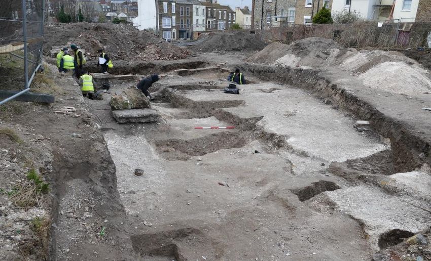
Introduction

The man-made underground structure known as Margate Caves was dug primarily as a
small chalk mine to procure chalk to burn for lime, with approximately 2000 tonnes removed
during the mine's active life. Sometime after abandonment it was rediscovered and adapted
for use as a wine store, ice well and later was opened to the general public in 1863. It
remained open on and off as a popular visitor attraction until 2004 when it was forced to
close by the Health and Safety Executive because of safety concerns.
The local community objected strongly to plans to build over the site and the Friends of
Margate Caves was formed to save the Caves from being sealed. In 2013 a Charitable
Incorporated Organisation was formed (The Margate Caves Community Education Trust
TMCCET) to secure a long-term lease on the site and raise the funds needed to re-open the
Caves. Remedial work was undertaken so that the Caves fully complied with modern safety
regulations. In conjunction, an archivist was appointed to collate artefacts and archival
material relevant to the Caves and research its history, testing and challenging as
necessary, the hitherto accepted ‘facts’. This occasioned a major revision of its history, the
results of which, with referenced sources, are now lodged in the Margate Caves Archive.

This paper was originally published in 2009 and was based on a short report prepared for
the Heritage Development Advisor of Thanet District Council (TDC) and based on accepted
historical facts at that time. Since then a great deal of new background research has been
done by Chris Pearson, archivist of TMCCET, which has required a complete rewrite.

Acknowledgements

The authors would like to thank the following for their help and support in producing this
paper:
The Margate Caves Community Education Trust; Members of the Friends of Margate Caves;
Kent Underground Research Group members; the staff and volunteers at the Caves; and
local photographer Frank Leppard for providing the photographs.

Chris Pearson 1952 - 2021

Sadly, co-author Chris Pearson was a victim of the Covid-19
pandemic and passed away in February 2021 at the age of 68.
Chris served as archivist and researcher for both the Shell Grotto in
Margate and the Margate Caves and was a tenacious and thorough
researcher, always seeking out primary sources and with a
remarkable talent for unearthing new information. He was a quiet
generous man who will be sorely missed.

                                                                           Chris Pearson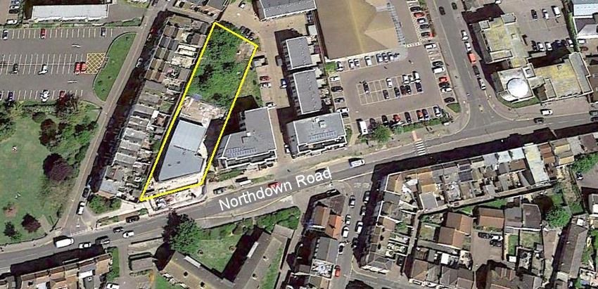
Location

The Margate Caves site is located at 1, Northdown Road, Cliftonville, Margate, Kent, CT9
1FG and is centred on NGR TR 3573 7114. It is situated on the north side of Northdown
Road, and lies approximately 350m east of Margate town centre and to the north of a dry
valley (Dane Valley) on a slight promontory known as Fort Hill.
It is bounded to the west by a narrow alleyway running to the rear of houses in Trinity
Square and to the east and north by land formally associated with the Capital House office
block which was demolished in 2011 and Sandhurst Place, a new housing development,
built. The southern boundary faces onto Northdown Road.
The underground features lie beneath the northern half of the plot which is roughly trapezoid
in shape with sides of 82m, 66m, 22m and 24m, enclosing approximately 0.2 Hectares. The
location of the original entrance shaft to the Caves is TR 35733 71157.

                   Google Earth Image (2019) of Margate Caves Site

Geology

The Caves have been dug into Margate Chalk, a division of the Upper Chalk formed around
72 - 86 million years ago. The chalk was originally overlain at this point with approximately
1.0m of Brickearth. As the chalk in this area approaches the boundary with the Brickearth it
becomes loose jointed with narrow horizontal beds and numerous vertical joints. This jointing
can be observed in the entrance passage to the Caves and also in the unlined chalk
passage at the nearby Shell Grotto, which lies approximately 360m to the south east.

Area History

The Kent Historical Environment Record lists numerous small archaeological excavations
and finds within 500m of the site, which have indicated that there was a substantial
prehistoric presence in the area.1
The most significant recorded archaeology adjoins the Caves site to the east and north and
was the subject of an archaeological evaluation by the Canterbury Archaeological Trust
(CAT) in January 2012, directed by Adrian G. Gollop BSc Hons.2
The evaluation was made as part of the preparations ahead of the proposed redevelopment
of the site, consisting of the demolition of existing buildings, including the Capitol House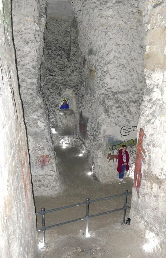
office block, and the erection of fourteen houses and two apartment blocks to form
Sandhurst Place.

The excavations found the remains of extensive Iron and Bronze Age occupation, including
a large ditch running north east to south west, which continued under the Caves eastern site
boundary. The evidence points to a hill fort or defended settlement on the top of the hill

Prior to the erection of
the new visitor centre,
TMCCET commissioned
an archaeological
evaluation of the site
that was undertaken by
the Swale and Thames
Archaeological Survey
Company (SWAT
Archaeology) in April
2018 and directed by
Dan Worsley.3
It was conducted as a
community-based
project with members of
the public encouraged
to participate under the
guidance of professional archaeologists.           Community Excavation
This was very successful, with a large number of volunteers helping to uncover the past
landscape.

The two-week excavation found the continuation
of the above Iron Age ditch and evidence of
occupation in the Bronze and Iron Age, with
finds including a crouch burial of a 34-year-old
Iron Age male which was excavated on the last
day of the dig by an enthusiastic young
volunteer.
The archaeology examined by SWAT
Archaeology is likely to be an extension of the
enclosed settlement associated with the
possible promontory Hill Fort some 250m away.
Some of the finds are now on display in the
Margate Caves visitor centre.
                                                                Iron Age Crouch Burial
There was little substantial modern development in the area until the 18th century. The area
was then known as Hooper’s Hill, named after Captain Stephen Hooper, a retired seafarer,
(c1734-1812) who had erected a horizontal corn mill on the hill just to the east of the Caves
site approximately 25/30m from the position of the original shaft.
Hooper had patented the design of the mill in 1770 and ten years later erected the unusual
design at Margate in 1780.4
Hooper also had built a substantial dwelling house to the south west of the mill buildings
around the same time as the mill was being constructed in the 1780s, which he named
Hooper House. It is highly likely that he also built the red brick mansion abutting it on the
west side, which became known as Bryan house, later to be renamed Northumberland
House. The house was situated on Hooper’s Hill, subsequently renamed Northumberland
Road, and now Northdown Road,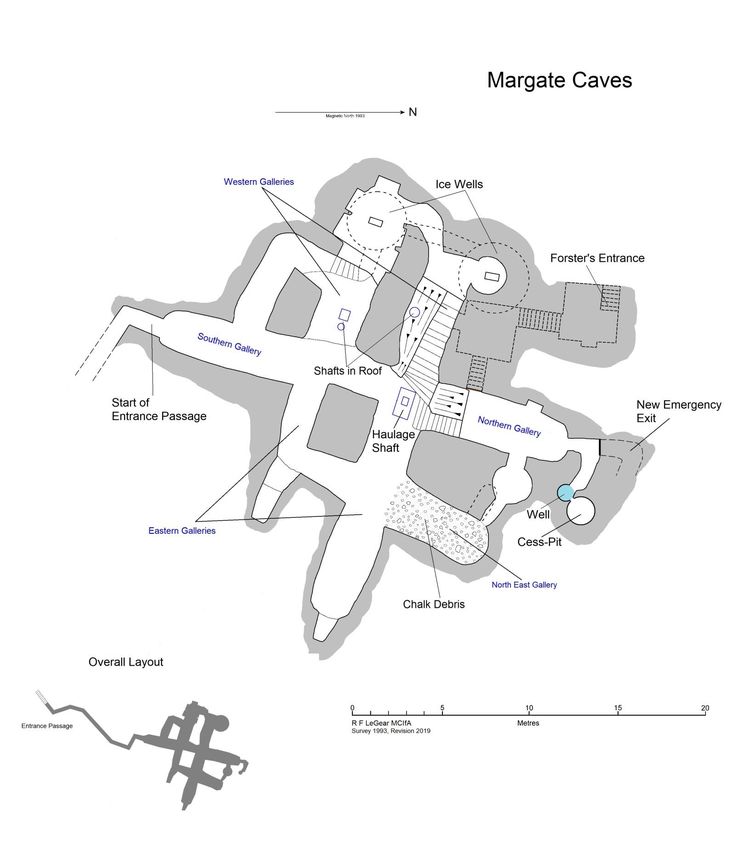
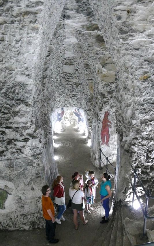
Description

          North – South Gallery                                 East – West Gallery

The Caves consist of a number of lofty hand-cut chalk galleries leading from a rectangular
shaft, with other tunnels cut at right angles to them to form pillars of unworked chalk to
support the ground above, a form of mining known as 'pillar and stall' or 'room and pillar'.
At the end of the northern chamber a short passage leads to a well shaft more than 13m
deep, which also continues 8m upwards to the surface where it is capped. This passage also
gives access to the modern emergency exit stairs. The northern chamber also contains the
bricked-up remains of an old entrance stairway. A low passage leads to a small circular
chamber, which has another small passage that links with the north east gallery. The north
east gallery contains a small passage dug after mining had ceased, heading under the
circular chamber.
Both of the western galleries have small blocked shafts in the roof that once opened to the
surface. The southernmost of the two western galleries has a modern iron utility pipe (a
sewer) crossing the roof.
One of the western galleries has suffered minor roof falls over many years to the extent that
the soffit has migrated up to within a few centimetres of the top of the chalk stratum.
The two western galleries are linked by a short tunnel excavated post extraction.
Off of one of the western galleries a small round chamber has been excavated in the floor of
which is the entrance to a former ovoid-shaped ice well.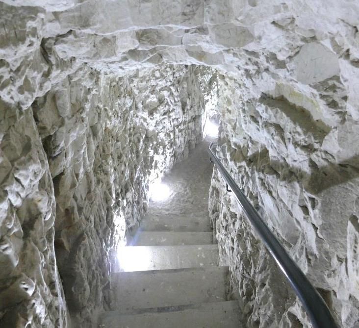
The other western gallery contains the entrance to a second ice well and has a series of
shallow recesses cut into the walls, which may have been associated with the use of the
Caves as a wine cellar. The two ice wells are linked together by a small tunnel at a lower
level and joined to the main caves by a similar short passage.

At the end of the two eastern galleries are deep alcoves dug post extraction and almost
certainly associated with the tourist industry. Old guide books describe one of the eastern
galleries as having a fossil ammonite in the wall. There is, sadly, no trace of it now. It is
suspected that it was removed by an unscrupulous visitor sometime in the past.

                                    Wall Art

Over the course of some two centuries the walls have been boldly decorated with paintings
depicting various animals, soldiers, old kings, an icon, a giant and a hunting scene.

                                     Visitor Centre

The present entrance to the Caves is via a long, sloping, relatively modern passage from the
visitor centre.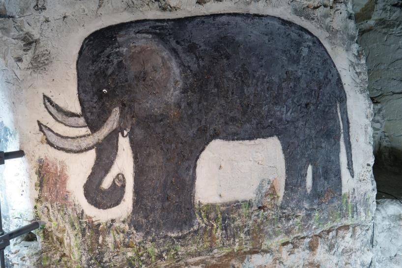
Plan of Caves
Method of Working

A spot was chosen near to where the chalk was required. Initially a rectangular shaft, 1.7m
by 1.0m, was sunk through the overlying Brickearth and topsoil into the chalk.
After leaving approximately 2m for roof
cover, three galleries were started, heading
roughly north, east and west. A fourth to the
south was started slightly lower down.
The use of a rectangular shaft is somewhat
unusual; a circular shaft is by far the most
common form, although other rectangular
shafts have been recorded at Way near
Manston5 and at Brambling.6
The chalk was hauled to the surface in stout
baskets using either a simple windlass or a
pulley suspended from a stout wooden tripod
or frame, and the rope attached to a horse
which would walk away from the shaft top
and thus pull up the heavy load.                         Original Haulage Shaft

The mining team would have consisted of two or three men on the surface to unload the
baskets and transport the chalk to the kilns and two men working underground: one to cut
out the chalk from the working face and the other to barrow it to the shaft bottom.
Smaller agricultural chalk mines known as chalkwells that were being dug in Kent around the
same time as Margate Caves had a smaller team of two on the surface and only one man
working underground. The cost to the farmer at that time was up to £10 for a mine that would
yield around 350 tons of chalk, enough to give a heavy top dress of 60 tons per acre to
about six acres of farmland to neutralise acidic soil.7
The principal headings at Margate Caves are in the order of 8.0m to 9.0m high and 2.5m to
3.0m wide at floor level. The galleries were dug in stages, the miner first cutting a passage to
the height he could easily swing his pick (approx. 1.9 - 2.0m). Great care was taken in
shaping the profile of the roof to give a strong load bearing cross section. This task was
always undertaken by the most experienced of the underground team.

To increase the output of the mine without extending its surface footprint, the shaft bottom
was lowered around 1.3 -1.4m and the floors of the galleries were progressively excavated
down to that level outwards from the shaft. This process was known as 'bottoming' and the
amount removed known as a 'lift'. The bottoming was repeated several times at Margate
until the galleries were about 6.8m deep.
The northern and western galleries remain at this depth. This level can be discerned as a
faint horizontal line in the walls of the other deeper galleries.
Approximately 1150 tonnes of chalk were removed at this time.
In a second phase of working the floor levels in the other galleries were taken down another
2.6m, removing a further 760 tonnes and leaving gallery heights of 9.4m.

A small remnant of the penultimate floor level can be seen as a platform 0.8m high at the
end of one of the eastern galleries. Many chalk mines have these benches which have, in
the past, led to exotic tales of Druid's altars etc. At the ends of both eastern galleries are
deep recesses excavated post mining and thought to be associated with the tourist industry.
The reason the miners did not take down the level of the northern and western galleries is
not clear. The commonest reason for a miner not to continue excavation in a particular set of
tunnels was safety. If he considered that there was a possibility of roof falls or collapse, the
area was left, and no further work carried out in the immediate vicinity.
Towards the west of the shaft the thickness of the chalk roof diminishes making the roof
level vulnerable to failure.
Crossing the northern gallery is a geological fault which may also have influenced the
decision to stop working in this area.
Another possibility is that the shaft was reopened and the mine reworked at a later date and,
noting the possible stability issues, the new miners only removed chalk from what they
assessed as the sounder areas.
Tool marks are abundant throughout the caves and show that the excavation was dug using
a short-headed iron pick typical of underground mining work.
The long gallery lengths indicate that some form of underground transport must have been
used to convey the chalk from the working faces to the base of the shaft. In chalk mines of
this size a simple wheelbarrow was usually employed. As barrows were not generally used
in vertically accessed mines in Kent until sometime after the 14th century, the old guide
book8 claim that the Caves were extant in Saxon times may be regarded as doubtful. In the
roof at the base of the shaft are a number of shallow grooves cut by the rope as the heavy
loads of chalk swung from side to side during haulage to the surface.
The north east gallery has experienced sporadic roof falls and has also been used as a
dumping area by various lessees to deposit cleared chalk rubble from minor falls. It may also
have been used to dump excavated chalk during some of the post-mining alterations.

The relatively modern entrance passage was dug down from the Northumberland House
cellars but nearly missed the Caves. A short link tunnel had to be dug at right angles from an
existing alcove in the southern gallery to intercept the new tunnel. Before the top end of the
passage was stabilised as part of the remedial works, a rubble filled passage could be made
out heading west. It is possible that this was where the spoil from excavating the long
sloping passage was taken to the surface, as it was unlikely that several tons of chalk would
have been taken up through the cellar.

The layout of the Caves and the mining techniques employed would suggest they were dug
in the mid to late 18th century, which would have made it a convenient source of chalk to be
burnt for lime for the mortar used in the construction of the nearby Horizontal Mill, Hooper’s
House and Bryan / Northumberland House.
When chalk extraction ceased the mine was abandoned and the shaft was capped with a
brick arch, set a little way down from the surface, and back filled to ground level.

Post-Extraction History

The history of the site as given in old guide books9 states that in the latter half of the 18th
century, a gentleman named Francis Forster built a large red-brick house on the site, which
he called Northumberland House. In 1798 his gardener, whilst digging behind the building,
discovered the Caves by having the ground give way beneath him. Another version refers to
a rabbit hole under a pear tree which was found to enter the caves. The mention of a pear
tree is interesting, as in northern France it was common to plant a pear tree over a blocked
mine shaft to mark its position.10

One of the more recent guide books after April 1995, (drawing on a 1917 newspaper
article14) gives the following description of the rediscovery of the caves:

       "Somewhere near the close of the 18th Century, a man of eccentric habits, named
       Francis Forster, built a large house which he named after the county of his birth —
       Northumberland House. In or about the year 1798 his gardener, digging behind the
       house, made the discovery of the Caves. A private entrance was cut. It was during
       this time that the cave murals were created. According to local folk-lore the pictures
       were painted by a local artist named Brazier, who unfortunately destroyed many
       interesting and valuable tool marks on the great chalk walls in order to obtain a
       smooth surface on which to execute his handiwork."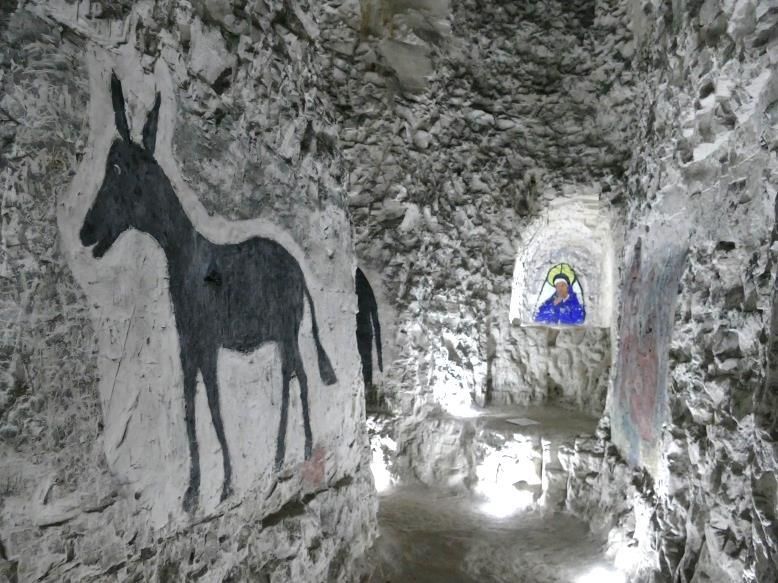
Research by archivist Chris Pearson has shown that the given discovery date of 1798 is
extremely dubious.
The red brick mansion was probably built sometime in the 1780s by Captain Hooper, and by
1791,11 was in the occupation of Mrs Margaret Bryan, who ran a girls’ boarding school on the
premises, which was named Bryan House at that time. In 1798 she moved the school to
Blackheath12 and records of the Sun Fire Office13 show the property was sold to Thomas
Brett, who in turn sold it by auction to Francis Forster (1771-1835) in 1807. Up to that time
there were no references to any caves or underground features on the property.
In 1917 a local historian named Charles James Fèret (1854-1921) visited the Caves and
wrote several articles in the Isle of Thanet Gazette:14
       “Passing through a small arched
       passage, we reach the entrance to
       the small dungeon. On a wall hard
       by, cut somewhat deeply into the
       chalk, are the letters C.F.F. and
       the date 1808, probably the initials
       of a member of the Forster family.
       Mr Forster's name was Francis
       Forster. The letters and the date
       are twice repeated, and in smaller
       and less distinct form, are the
       characters F R S T R”.                            Historic Graffiti
The initials were probably those of one of Forster's sons, Charles Francis Forster, who
would have been around 13 years old in 1808. The letters F R S T R could be simply Forster
with the vowels removed. The date coincides with when Forster acquired the property and
strongly suggests the rediscovery of the Caves occurred soon after he took up residence. It
was at this time that the house was renamed Northumberland House, after the county where
Forster's family were based. Therefore if the Caves had been discovered in Forster's time it
could not have been before 1807.
After the Caves were re-entered following their discovery, Forster had a proper entrance
constructed consisting of two sets of stairs from the surface, which entered the northern
gallery, making a more convenient method of descent.

Once the new entrance was in use, Forster began to commission some alterations to the
underground structure for his own use and amusement, including the addition of a number of
murals on the chalk walls.

A set of steps was cut from the northern gallery to the lower floor level and a similar set was
cut from the western gallery to give easier access to the lower level.

A short passage was excavated from the northern gallery to break into a 1.0m diameter well
shaft that descends 8.0m from the site of the stables above. The shaft descends a further
13.7m from the passage floor where it reaches the local water table. The full depth of the
shaft cannot currently be determined because of the amount of detritus and fill at the bottom.
A little way up the well shaft is an opening on the north side which has caused several
rumours of the existence of a smuggler's tunnel at this point. However, when investigated by
members of the Kent Underground Research Group (KURG) in 1993,15 the opening was
found to lead into the bottom of an old cess-pit. At some time in the distant past, probably to
avoid the cost of emptying, the wall of the cess-pit had been knocked through so that any
effluent would drain into the (hopefully disused) well shaft. There is mention of the well in a
description of Northumberland House garden in 1854 in The South Eastern Gazette for the
15th August p. 8:
“Under a portion of the garden is a curious cavern, part of which is fitted up as a wine
cellar; it also contains an ice-well, and well of excellent spring water, &c. &c.”
A small chamber was constructed to the right of the main western gallery and an ovoid-
shaped pit, to be used as an ice well, was dug in the floor.
At some point, another ice well was excavated in the adjoining western gallery and a number
of recesses were cut into the walls of this gallery at the same time.
A sketch plan of “The Vortigern Caves”,
dating to about the time the property was
advertised for sale in 1865 and 1866,
shows only the northern ice well, which is
clearly labelled as such. As the second
one is not depicted on the plan, the
southernmost ice well was most probably
constructed at a later date. Both of the ice
wells have small drainage sumps sunk in
their sloping bases to drain off melt water.
Unlike a county estate, where ice collected
from lakes or compacted snow would have
been used to fill the wells, Forster would
have had to purchase imported ice
sourced from America or Norway. The
importing of ice to Britain was a big
business; in 1888 the U.K. imported
340,000 tons of ice from Norway alone.16
Forster was said to have used the Caves
not only as his private grotto but also to
store wine. At some time post mining a
small round chamber, similar to that above
the northern ice well was dug to Early Sketch Plan
the east of the main northern gallery. A small passage links this chamber to the north east
gallery where a short, seemingly unfinished, passage heads under the circular chamber. The
purpose of these excavations is unclear although it is possible that a third ice well was
planned but never constructed in this position.
Both of the western galleries have small blocked holes or shafts in the roofs that once
opened to the surface. Their original use is unclear but may have been utilised when filling
the ice wells with ice. It is also possible that one of them was the result of the miners
breaking into the bottom of a Bronze or Iron Age pit.
Forster had the chalk walls of the Caves decorated with many paintings using distemper
paint. The images are thought to be similar to those that can be seen today, although, over
time some have faded away and have been lost.
After Forster's death in 1835 his family and subsequent owners of Northumberland House
largely ignored and neglected the Caves.
In 1863, a flamboyant local shopkeeper, John Norwood, (1815-1889) rented the Caves from
Edmund Firkins. Edmund Firkins (c.1807-1880), was a builder and gentleman, former
fishmonger and licensed victualler, from London. When he actually purchased the
Northumberland House Estate is not certain; it could have been as early as the auction sale
in August 1854. However, in 1861 he married Margaret Daly, the housekeeper at
Northumberland House, and moved in with her. The mansion and rear garden, effectively,had been divided into two properties, and he occupied the west part, the part under which
the Caves lay. Firkins had been trying to sell the Northumberland House Estate from 1862.
He finally sold it around 1868 and moved out.
The extent of Firkins’ involvement with Norwood in the “Vortigern Caves” project is uncertain.
Perhaps it can be compared to the nearby Shell Grotto, when, three decades before,
schoolmaster James Newlove saw the structure that lay under his garden as an asset to be
exploited as a business venture by remodelling it as a visitor attraction, not necessarily to
run himself, but to receive rental income, from a tenant. In Newlove’s case, James Stodart
ran the attraction for several years. Firkins may also have taken some responsibility for the
remodelling and decoration of the Caves.
Norwood was a well-known local entrepreneur who owned a hardware and grocery store in
Cecil Square, Margate. He was also a local postman and a bill-poster. He would have been
an excellent candidate to front and promote the “Vortigern Caves” venture.
A small cottage, ticket office and shop were erected next to the Caves entrance and the site
was open to the general public for the first time under the name “Vortigern Caves”.17
Fèret, in the two articles published in the Isle of Thanet Gazette,18 mentions that work had
been carried out on the Caves in the years just prior to their opening, by his friend John
George Bushell (1842-1922)
He quotes Bushell as saying:
"When a boy, my friend and his uncle were employed by Mr. Forster to make
extensive alterations and excavations. He tells me that they excavated a great
quantity of chalk, which was carted away to the lime kilns.” (1917).
Possibly resulting from the fact that he was illegitimate, there is a little confusion, as in the
1919 version he states that his friend worked with his father not his uncle:
“When a boy, assisted his father in connection with work at the Vortigern Caves”
As Fèret's friend was born in 1842 it is unlikely that they were employed by Forster himself
as Forster died in 1835, although two of his daughters lived in Northumberland House until
1855/6. Exactly when this work in the Caves was done cannot be accurately determined at
this time.
If these excavations were done a little before 1863 they would coincide with the building of a
row of seven houses, (nos. 5-11 East Crescent) and also no.17, which all formed part of the
Northumberland House Estate. It is possible that the 'chalk carted to the lime kilns' was used
in the construction of these properties. There is also a possibility that it was at this time that
the second phase of excavation took place.
Lighting for Norwood's visitors was initially provided by candles in sconces on the walls. By
1866 the lighting was provided by gas jets and it was probably at this time that a small
ventilation shaft was constructed through the main shaft capping. It is still possible to see
small patches of soot on the walls from this naked flame illumination.
The alcoves at the ends of the eastern galleries, at least one of which is said to have held a
religious icon, were probably from this period.
The illustrations on the walls from Forster's time were, by now, much degraded and very
faint and most have been lost, overpainted, or repainted and enhanced, whilst completely
new ones were also added.
It was Fèret’s friend, Bushell, through the filter of Fèret, who had claimed that a local artist,
named Brazier (or Brasier), was responsible for at least some of the paintings, suggesting
that they had been done at the behest of Forster. As this is the only source for the name,Brazier, and, given that Bushell was not even born when Forster died, but had done work in
the Caves around Norwood’s time. The possibility cannot, therefore, be ruled out that
“Brazier” may have been responsible for work done on the murals, for Norwood, or the
Cave’s then owner, Edmund Firkins, rather than Forster, and that he was not responsible for
the original “Forster” paintings.
“When a boy, my friend and his uncle were employed by Mr. Forster to make
extensive alterations and excavations. He tells me that they excavated a great
quantity of chalk, which was carted away to the lime kilns. In those days they were
called Forster’s Caves. The proprietor employed a clever workman, named Brazier,
to paint some of them. Thus, one panel would represent a postchaise, the next a den
with a tiger, and a third a landscape. In all, Brazier embellished the caves with some
thirteen or fourteen scenes. The last one depicted a prisoner in the care of sentries
with fixed bayonets, chains enveloping the limbs of the unhappy man. In working in a
room just above, the boy and his uncle had a slight accident – they broke through the
floor into the recess occupied by the painter’s prisoner!”
A description of the Caves a short time after they were opened can be found in an 1866 local
guide book of the area19 which states:
“There is an exhibition in Margate which goes by the name of the Vortigern Caves,
and is a good deal patronised by courting couples and nurses with young children,
simply, we suppose, because it offers to the juvenile mind the attraction of a faint
kind of horror. We find it mentioned in print that "the antiquity and use of these caves
being recorded in history, any attempt to describe them would fail to convey to the
mind the ingenuity and labour bestowed on their construction. These caves are the
most extraordinary that have yet been discovered; and there can be no doubt,
sheltered the Saxons from the ruthless cruelty of the Danes” We need hardly tell the
reader that there is no foundation whatever for these statements, and that no one
knows when and by whom the excavations were made.
“They were discovered by a mere accident by an old gentleman who owned the land
above, and he being of a whimsical turn of mind had them decorated in the absurd
fashion in which we find them at present. We should mention that the entrance into
the so-called Vortigern Caves is by a narrow turning beside the schools belonging to
Trinity Church. You enter a little shop where ginger beer and barley sugar, and
London Journals and Family Heralds are retailed, and are ushered down a flight of
steps when, by the dim light of a few jets of gas, you discern a series of excavations,
and gradually recognise some wretched paintings in distemper on the flat surfaces of
the chalk.”
It is also highly probable that many of the myths and stories about the Caves can be sourced
back to Norwood's time. Despite being a popular site for visitors, after only five years, the
enterprise foundered and the site was put up for rent as the following advertisement
appeared in a local newspaper;
“TO BE LET - The celebrated V0RTIGERN CAVES, MARGATE, together with
COTTAGE, containing Three Rooms.—For Particulars apply to Mr. Firkins,
Northumberland House, Margate.” 20
No tenants were found to take over the business and the site remained closed, although
some access was still possible, as a letter in Keble’s Gazette in 1902 stated:
“…there is a large cave or series of caves running under the garden of the Holy
Trinity Vicarage. The caves are entered from a cottage at the rear of the TrinitySchools and although now closed to visitors, permission can be obtained from the
owners of the adjacent stables to explore them.”
Several years later the western half of Northumberland House was taken over as the
vicarage for Holy Trinity Church, which had been constructed to the north west of the site
and was consecrated on 11th June 1829.
The Reverend Michael Pryor (1857-1929) was inducted to Holy Trinity on 16th October 1902
and became a hardworking, dedicated vicar known for his driving forward restoration work
and alterations to the church. In 1906 he was awarded a Doctor of Divinity degree and the
parish presented him with a cheque for £50 to defray the cost of his robes. In 1915 he was
appointed to an honorary canonry at Canterbury. He died on the 11th June 1929.21
Dr Prior developed a great interest in the Caves and in 1907 re-opened the old entrance
stairways and started clearing out the accumulated debris from the Caves with a view to
restoring them to public view.
In 1908 he found the tops of the ice well or wells during clearance in the western galleries.
Most accounts state that it was he who had the lower level passage dug to access the
bottom of the pits and link them together. He may possibly have even gone further, and have
been responsible for the second pit, constructed to enhance the visitor experience.
He set about cleaning up and revitalising the Caves as a tourist attraction, instituting many
improvements, such as upgrading the stairways and possibly cutting the new entrance from
the vicarage cellar.
During this time two sets of photographic postcards were produced, one set dating to no
later than 1908, when some bear that post date.
Some of the photographs seem to include workmen. The
second set, originally photographed by Edwin Major
Dungey (1871-1963), are probably a little later, between
about 1912-1914. Together they are a useful source for
tracing the development of the Caves – for instance one
of the 1908 postcards the ‘Thanet Hunt’ mural has been
cut through by a large recess in the position of the
modern entrance passage. As the arch was supposedly
made as part of Pryor’s new entrance from the vicarage
cellars, usually dated to 1914, it suggests that the new
entrance may possibly have been earlier.
One of the noticeable features of the photographs is that
the paintings, executed up to 100 years before, are barely
visible. Ghost images of some of these older paintings
can still be discerned today.
The passage to the well was cleared by 1910 and the
enterprising vicar opened the Caves to the public
whereupon they quickly became a popular Margate
attraction once again. 1908 Photograph
In a letter dated 6th September 1912, addressed to The Vicar of Holy Trinity Church, the
Reverend Michael Pryor, Miss Grace Brookes (1859-1929), Francis Forster’s great grand-
daughter gives an account of the circumstances surrounding the discovery of the Caves.22
She writes:-6th September. 1912.
To the Rev. M Pryor.
"Sir,—On visiting the Vortigern Caves this evening I learnt from the Verger that the
frescoes adorning the walls were supposed to have been executed by smugglers. I
should like to correct this error. My great grandfather, the late Francis Forster, of
Northumberland House, Margate, was, I believe, the discoverer of these caves, his
gardener, while digging, chancing to come upon a hole which, on investigation,
proved to lead down into the Caves; he opened them out to a certain extent, and had
the walls adorned with pictures. He used to take his friends down and used to light
them up, but the Caves were not open to the public till after his death, when the
property passed out of the family.
Francis Forster died in the year 1835, aged 63 and had been living in
Northumberland House for some years prior to his death. He named the house after
his county, he being a member of the Forster family of Etherston and Bamborough,
Northumberland. He was the last of his family to own the Northumberland Estates,
the entail of which was cut off, and the estate sold to pay his debts. My late mother
was a Miss Forster.
I am, faithfully yours, Grace Brooks"
The old guide books and other
sources23 state that in 1914 a sloping
passage was cut from the cellars of
the Vicarage so that the incumbents
could quickly gain the safety of the
Caves during the air raids of World
War 1. It is probable that the general
public were allowed access through
the ‘tourist’ entrance in the Vicarage
garden.
This date for the digging of the tunnel
is a little questionable as
Northumberland House had strong
cellars, which would have been seen,
at the time, to be adequate as a
shelter. This was confirmed when, in
World War 2, the then vicar elected to
shelter in the cellars when the
vicarage was damaged by enemy bombing in 1941. Entrance Passage
The mid-Victorian plan of “The Vortigern Caves” does not show this entrance and, although
one of Dungey’s 1908 photographs shows an alcove in the position of the lower end of the
tunnel, it is by no means certain that the alcove connected to the tunnel at that time.
The digging of air-raid shelters (or dug-outs as they were called locally at the time) did not
commence in earnest in Thanet much before 1917, when concentrated raids by German
heavier than air Gotha bombers became more frequent.
In 1917 the local authorities in Thanet held joint discussions that resulted in civilians being
asked to volunteer to help in the digging of shelters.24 On a list of proposed shelter sites the
Caves are noted as Vortigern Cave. Nearby, a new shelter was excavated in the south east
corner of Trinity Square. In the 1930s when the likelihood of another war was growing, a
plan of locations of the First World War public dug outs was produced by Bayly, a localsurveyor.25 This shows the position of the Trinity Square shelter but the Caves are not shown as a shelter site. After the First World War the Caves were re-opened for tourism. However, by 1938 they were closed again as the area was scheduled for improvement under a scheme called ‘The Zion Place Redevelopment Plan’. At the outbreak of the Second World War the Caves were used as an air-raid shelter for the vicarage. On Sunday 21st September 1941, Northumberland House was severely damaged by enemy action, as was Holy Trinity Church, on Tuesday 1st June 1943.26 During site clearance the entrance stairs were filled with rubble and covered with concrete slabs. The severely damaged shell of the Vicarage / Northumberland House and the remains of the church were finally demolished early in 1958. The entrance passage to the Caves from the vicarage was blocked by demolition debris filling the cellar. In the spring of 1958, James Geary Gardner (1903-1987), the proprietor of Chislehurst Caves and other underground tourist caves in Kent, became interested in the site and sought to relocate the entrance into the Caves. Permission was sought and granted from the Benefice of Holy Trinity Church, who still owned the land. A concrete slab at the top of the old vicarage garden was lifted to reveal Forster's original entrance steps. Having gained access, Gardner enlisted the help of students, many from the Margate School of Art, to clear the rubble from the Northumberland House cellar entrance. A set of modern covered steps was constructed from the surface to reach the newly-cleared chalk passage and two wooden huts, for use as a ticket office and gift shop, were erected. Electric lighting was installed in the Caves, the paintings retouched yet again, and the Caves once more opened to the paying public on Saturday 24th May 1958 with an admission price of l/6d (7.5p).27 At around this time the image of the ‘Thanet Giant’ which glowed in ultraviolet light, was added by James Gardner. 28 For the first time, a small guide book,29 was produced, written by George E. Clarke, F.L.A., Borough Librarian and Curator, and Chairman, Isle of Thanet Archaeological and Historical Society. It was based on Chapter 12, “Vortigern Caves” from his 1957 publication “Historic Margate - Reprints of a series of articles published in the Isle of Thanet Gazette - Illustrated with contemporary prints”. The “Isle of Thanet Gazette articles” were those of Charles Fèret, written 1917-1919. Also a set of four photographic postcards of the Caves’ interior was produced at this time, by the Central Press Margate. The VistaScreen Co Ltd also produced a booklet, (Series H120), containing a set of ten 3D stereo view cards, which gave a 3D effect when viewed through a special viewer. Based on contemporary photographs, both show how the Caves looked in the late 1950s and early 1960s. The photographs used for the set of postcards were also reproduced in Clarke’s booklet. In August 1962 Gardner had to relinquish the lease with the Church authorities, when the site of the old vicarage, together with Caves underneath the garden, was compulsory purchased by Margate Council in view of the proposed development of nearby Zion Place. Gardner was then granted a renewable fourteen-year lease from Margate Council (TDC) from April 1974. In the period 1st April 1980 to 31st March 1981, takings for the Caves totalled £5929, with a total net loss of £99. In the next year takings totalled £5697 with a loss of £4. Ticket prices at this time were: Adults 30p, Children 15p. The Caves were open daily during the summer, 10am-6pm.30
In around 1984, artist Karol Edward Osten-Sacken spent a few weeks working on restoring
the Caves murals. It is thought that he restored all, or nearly all, of the paintings, and that he
added some works of his own. The painting of the head in the horned helmet is possibly a
self-portrait. He almost certainly worked in emulsion paint.31
Gardner wanted to purchase the freehold of the site from the council but in 1987 a local
newspaper32 reported that Thanet District Council would not sell to Kent Mushrooms Limited,
the Gardner family company running the Caves, and so his plans were thwarted.

In September 1987 James Geary Gardner died and the managing of the Caves was
continued by his son, also named James Gardner. In 1988 a new wooden ticket office and
gift shop were opened. In that year the Caves had attracted some 20,000 visitors between
April and October with an adult fee of 60p. It was estimated that 10% of visitors were from
overseas.33

Kent Mushrooms Ltd relinquished the lease with TDC when it expired on 24th March 1991,
thus reverting control to TDC. After this time the site was only leased out on shorter-term
lets.

In January 1992 Wolfgang and Eileen Heigl took on the lease for the Caves and nine months
later were complaining of the lack of help from Thanet District Council as a newspaper article
in September of that year records:34

       “Last year (1991) Mr Heigl decided that there might be benefits to be had from
       getting a greater presence in Margate's tourist industry. The lease on the council-
       owned Margate Caves came on the market, and Mr Heigl took it. Those who are
       familiar with caves are unlikely to be much impressed by Margate's version, with
       cave paintings which, far from being prehistoric, are said to date from the beginning
       of the 19th century. However, the Caves have now been embellished by the stories of
       torture and smuggling which so delight young visitors and are a reasonable addition
       to a holiday itinerary for a wet afternoon.
       … But he does suggest that the local council might do a little more to help him in his
       endeavours to entertain Margate visitors. He wanted to install a proper lavatory at the
       Caves and was told that he would need the landlord's permission.

       "The landlord is the council and it said that it would charge £75 to give permission,"
       he says. So there is no new loo, or other improvements he would like to make at the
       Caves. "If I owned them, then it would be different," he says, a fact of which he has
       already apprised several councillors… He keeps the entrance fee down to 80p, low
       by comparison with most tourist attractions. "Because I want as many people as
       possible to see it."

A year later in 1993 members of the Kent Underground
Research Group (KURG)35 volunteered to clear the well shaft
of accumulated rubbish and debris.
The top of the debris was 4.5m below the passage floor and
consisted of fine dry soil and much litter thrown down by
inconsiderate visitors.

After several visits 6m of fill was slowly removed, the majority
being thought to be debris from when the Church and
Northumberland House were demolished in 1958.                              Well Shaft
At that time it is possible that the top of the well shaft was open or had a simple cover on the
surface and it became a convenient void to get rid of rubble.
Several hundred coins dating back to the mid-1880s were recovered as well as old oil lamps,
green glass fragments and numerous Victorian and later bottles and pottery.
At a depth of 13.7m the digging was abandoned after encountering the water table.
The opportunity was taken to examine the supposed entrance to a smuggler's tunnel located in the side of the well shaft between the cave entrance and the surface. This opening was found to lead into the bottom of an old cess-pit associated with the former livery stables above. The KURG team then turned their attention to the melt water sumps in the two ice wells. These were cleared of rubbish and found to be 1.5m and 0.6m in depth. No notable artefacts were recovered. Sadly lack of investment from subsequent lessees over the following decades led to poor maintenance of the visitor infrastructure causing a number of safety concerns. Closure In 2004, following a complaint from a member of the public to the landowners, Thanet District Council, the Caves were visited by an officer of the Health and Safety Executive who issued a Prohibition Notice36 dated 6th September 2004 to the landowners and Mr Safaa F. Al-Khudairi, the lessee. The Caves were then closed and entry forbidden until remedial work was carried out. Following the closure, Thanet District Council commissioned a structural survey of the Caves from a specialist company, Atkins, who produced a detailed report on the condition of the Caves in 2005.37 The report also gave Atkins’ recommendation of the work required to be done to make the site safe and thus have the Prohibition Notice lifted before any re-opening of the site to the public. Six years later in 2010 a planning application for a residential development, consisting of seven two and three-story buildings, with ancillary parking and the creation of vehicular access on the southern part of the site, was submitted by TDC.38 In order to build over the Caves entrance passage it was intended to fill the tunnel with concrete, thus rendering access to the Caves impossible. The application was not proceeded with following strong local objections to the potential permanent loss of the Caves. In March 2011 the Friends of Margate Caves (FOMC) submitted a concept proposal to TDC for the future of Margate Caves. In early 2011, following a number of break-ins, workmen from TDC demolished and removed the two old wooden ticket office and gift shop huts and covered the entrance with a concrete slab. Access was retained via a welded shut manhole cover. At the same time other measures to make the surface area safe were undertaken including placing a large concrete raft over the area where the Caves roof was considered to be most vulnerable to collapse. Rebirth In October 2011 the FOMC commissioned Graham Daws Associates Ltd (GDA) to carry out an inspection of Margate Caves and make recommendations for remedial works which would be required in order to re-open the Caves.39 GDA is a firm of Rock Mechanics Consultants that specialises in assessing the stability of underground excavations, including mines and tunnel projects, and have extensive experience working on tunnels excavated in chalk. Late in 2013 some committee members from the Friends of Margate Caves formed The Margate Caves Community Education Trust (TMCCET), a registered charity. The move recognised the great deal of work required to ensure that the Caves site was developed with the best interests of its community at heart. TMCCT continued the Friends’ work to secure a long lease on the site from Thanet District Council, develop plans for the site and raise the funds needed to re-open the Caves.
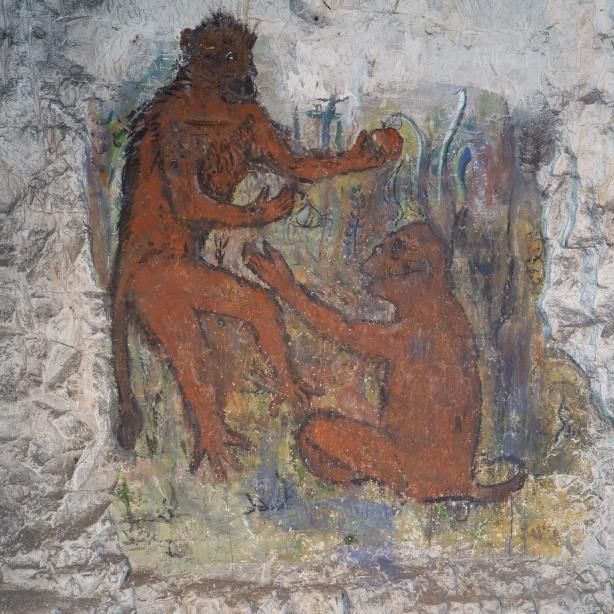
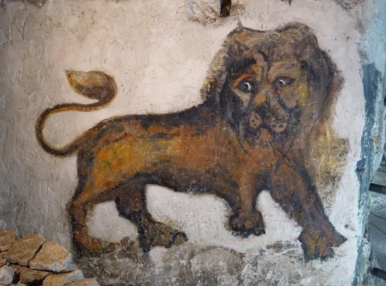
Specialist contractors, High Peak
Geotechnical Ltd., were engaged to carry out
the recommended underground work which
included stabilisation of some areas and the
excavation of a new emergency exit from the
northern chamber.
At the same time, architects Kaner Olette,
were appointed by the Trust to submit a
planning application40 and design a new
modern single-story visitor centre
incorporating a ticket office, café, community
rooms and an interpretation room that would                    Remedial Work
give the full history of the Caves and their context in the local landscape.
When all the underground work was completed to the satisfaction of the Health and Safety
Executive the Prohibition Order was lifted. The visitor centre was finished in August 2019
and the Caves finally reopened to the public on Thursday 22nd August 2019. More than
5000 people visited the Caves in the first two weeks.

On 11th June 2020, Margate Caves was declared the winner of the South-East Region RICS
(Royal Institution of Chartered Surveyors) Social Impact Award for Heritage.

The Wall Paintings

Before the Caves were opened to the public by Norwood in 1863 the original paintings,
allegedly completed by Brazier in Forster’s time, had deteriorated and faded. They are
barely made out in Dungey’s photographs. By the time customers were paying their 3d
admission to enter, many of the frescoes had been repainted including an elephant, a
crocodile, a lion, a tiger and some Chinese prisoners in chains. Only faint traces of the
prisoners and the tiger have survived to the present day.
Over the years the paintings have been repainted and retouched many times, so much so,
that some of the animals have become a little stylised. Some of the early works can be seen
as faint, almost invisible, ‘ghost paintings’.
Rob Smith, a conservation specialist, worked on the paintings to clean and preserve them
prior to the Caves opening to the public.
Some of the paintings found on the walls include: a hunting scene (The Thanet Hunt); a
crocodile; a fox; Vortigern; ‘God Bless the King’ and two figures; the Thanet Giant; a bear; a
donkey; the Virgin Mary; an elephant; a rearing horse; three deer; a boar; a hippopotamus; a
lion; remnants of an older representation of possibly the Virgin Mary or some other religious
icon; a running horse; and soldiers on sentry duty.
Location of Paintings
Examples of the Wall Art

      Donkey and Virgin Mary             Fox

           Lion                       King George

     Crocodile and King Vortigern

                                    The Thanet Giant
Monkeys Elephant
Stylised Hippopotamus
Soldiers
The ‘Thanet Hunt’Other Local Underground sites
In September 1959, a chalk cavity was discovered under the site of some 17th-century
cottages at Flint Row, Margate on the south side of Northdown Road, opposite the Caves
site. The cottages had been demolished the previous year to prepare the ground for the
erection of a three story ‘L’ shaped block of apartments to be known as Flint House.
Reports of the discovery stated that an 18inch manhole had been lifted to reveal a domed
chamber 26ft (7.9m) deep and 36ft (10.9m) across with several tunnels leading off. All of the
tunnels were said to be blocked after a short distance. The cavities were filled in and made
safe prior to the building works.41
The layout of the caves suggested that they may have been excavated or adapted in the
First World War as an air-raid shelter.
Another World War 1 shelter or 'dug-out' was excavated in the south east corner of Trinity
Square. A photograph appeared in a 1929 publication that shows a descending flight of
steps into a hand-cut chalk tunnel.42 There has been some speculation that this shelter may
have connected with Northumberland House cellars at the junction where the Caves entry
tunnel commenced. What appeared to be a rubble-filled passage was once visible before the
modern improvements were made, although it was more likely to be a spoil extraction tunnel
from when the long entrance passage was dug.
There is some evidence for chalk-cut tunnels to the north east of the Caves site, as an 1832
newspaper article43 reported that officers of the Margate custom house had searched a
property occupied by a man named Cook.
“…at the back of Zion Place near the Fort. They discovered, hidden by a secret
entrance”, a tunnel which was: “…just large enough to admit a man crawling upon his
knees”.
The officers followed the sloping tunnel down towards the sea shore, passing under several
houses for about “200 yards” until they reached the lower entrance on the north-west side of
Clifton Baths. This entrance was boarded over and had rammed earth and chalk covering it
to conceal it from view. Inside the tunnel were found several wheeled trucks:
“…and implements for the conveying of smuggled goods through the tunnel to
Cook’s house”.
Apparently this was the second such tunnel that had been dug under the same house within
two years.
In 1888 another cavity was found to the west of Northumberland House whilst workmen
were erecting a telephone pole:
“On Friday, whilst a hole was being dug for the purpose of sinking an anchor to hold
the stay of the telephone post on the east side of the green adjoining Trinity church,
the workmen, after they had got about five feet below the surface, broke into a cavity
that, upon exploration, was found to be one of the old smuggle holes. The cavern is
about sixteen feet deep, circular in form, and has a tunnel running in a northerly
direction, probably towards the sea, or, perhaps, connecting this cave with some
others which abound in the neighbourhood. On the floor of the cave a quantity of
bones, in a good state of preservation, were found, which were at first thought to be
human, but, during the week, they have been examined by several local medical
gentlemen, who all agree that they are the bones of some animal, but of what precise
species they are unable to form an opinion”. 44The Lido Tunnel
In Margate library is an undated, crude sketch
of a passage running from the Clifton Baths to
the Vortigern’s Caves. A copy of this plan used
to be displayed on the wall of Gardner's ticket
office. This and other documents were lost
when the wooden huts were demolished in
2011.
Exactly when the story of a tunnel from the Lido,
some 330m to the north, to the Caves was first
circulated is not known for certain. One version
of the legend is that boats laden with
contraband were, at high tide, floated along a
tunnel from the coast that connected with the
bottom of the well shaft. The smuggled goods
would have then been hauled up the shaft and
hidden in the chalk caves. The 1993 clearance
of the well found no evidence of any such
passage above the local water table level.
Guidebooks and newspaper articles describing
the Caves written before the 1960s do not
mention any such connection with the coast.
Lido Tunnel Sketch
The later guide books/leaflets suggest that the tunnel entered the Caves to the left of the
steps leading up to the northern gallery but ‘is now bricked up’. The writers suspect that the
stories have been encouraged as a means to attract more paying visitors.
James Gardner was a knowledgeable underground explorer and had experience of locating
and digging out backfilled passages in the large chalk caves at Chislehurst and elsewhere in
the county. If he had thought that there was a possibility that the tunnel existed he would
certainly have attempted to locate it and open the entrance up, as it would have been an
extra feature to show to visitors. The legend of a tunnel, however, is almost as good as the
real thing and the story started to appear in guidebooks of the 1970s and later.
Technically the excavation of a tunnel from the Caves to the coast is possible, as the
smuggling tunnel found at nearby Zion Place in 1832 proves.
The Caves are managed and run by The Margate Caves Community Education Trust. More
information on the Trust and the Caves can be found on their website:
www.margatecaves.co.ukEndnotes
1 R F LeGear A Desk-top based Archaeological Assessment of the Margate Caves Site,
Cliftonville, Kent commissioned by The Margate Caves Community Education Trust, 2014
2 Canterbury’s Archaeology 2011-2012 36th Annual Report of the Canterbury Archaeological
Trust 2013, p38-42
3 SWAT Archaeology Assessment of the Archaeological Strip, Map and Sample of Margate
Caves, Northdown Road, Margate, Kent Swale and Thames Archaeological Survey
Company, June 2018
4 Whereas a conventional wind-powered mill was driven by vertical 'sails', the horizontal mill
consisted of a tall tower 60 feet high and 16 feet in diameter in which fixed 40 vertical sail
blades were mounted on horizontal wheels. The tower had louvered sides which could be
adjusted to allow the prevailing wind through the tower to turn the blades. A central iron shaft
attached to the horizontal wheels simultaneously powered up to three pairs of overdrive
millstones on the milling floor.
5 John Archibald A Denehole at Hammhill near Eastry Archaeologia Cantiana LXVII (1935),
p216
6 D J R Ogilvie Denehole at Brambling Arch Cant LXXIV 1960, p190
7 John EL Caiger Some Early Chalkwells in N.W. Kent Arch Cant LXXIV 1960, p82
8 The Margate Caves, Northdown Road, Cliftonville, Central Press (Margate) Limited, High
Street, Margate, 1958
9 The Vortigern Smugglers’ Caves and Ancient Dene Holes, Margate, Clarke & Knapp,
Printers, Margate, c.1912-1914 (copy in Margate Library)
10 Pers. Com. Abbé Pierre Nollent at the Joint Symposium of Subterranea Britannica and The
Société Française D’ Etude des Souterrains Cambridge, 1974
11 Kentish Gazette 11th Feb 1791
12 Kentish Weekly Post 4th May 1798
13 Sun Fire Office London metropolitan archives CLC/B/192/F/001/MS11936/431/767685 from
1804-1806
14 Charles James Fèret, Bygone Thanet, Extracts from the Isle of Thanet Gazette, (1913-
1920), Margate Library, pp103-104 (11th August 1917), 152-155 (25th August 1917), 157-
158 (1917), and 215 (c.1919)
15 Ken Linsey and Paul Rapley The Margate Caves Kent Underground Research Group
Research Report 11, 1994, p9-14
16 S P Beamon and S Roaf The Ice Houses of Britain, Routledge, 1990, p47
17 Belfast News-Letter, Tuesday 7th April 1863, p3
18 See note 1419 All About Margate and Herne Bay Kent and Co London, 1866
20 Thanet Advertiser - Saturday 20 April 1867, p.2 - 18 May 1867, p2
21 Hugh Merscy Walton A short History of Holy Trinity Church Margate 1835-1932, published
by author, 1932
22 Charles Fèret, Bygone Thanet, Extracts from the Isle of Thanet Gazette, (1913-1920),
Margate Library, pp152-155, 25th August 1917
23 Granville Squiers, Secret Hiding Places and Descriptions of English Secret Hiding Places
used by Priests, Cavaliers, Jacobites and Smugglers. Stanley Paul & Co Ltd London, 1933,
pp272-274
24 Thanet in Wartime, J T Huddlestone (Chairman of Ramsgate ARP Committee) Published in
instalments in the Thanet Gazette ‘Thanet Troglodytes’ Chapter VIII, 14th June 1938
25 Plan held in Margate Museum
26 The Thanet Advertiser Friday 26 September 1941, p2 (Vicarage)
The Thanet Advertiser Friday 23 July 1943, p1 (Holy Trinity Church)
27 British Caver: A Netherworld Journal, No.30, 1958, p86
28 Richard Joy (1675-1742) was a Gentleman, a strongman known as “The Kentish Samson”
and reputed famous smuggler who was over 7 feet tall (2.13m) and weighed 25 stone (159
kg.) He died in May 1742 and is buried in St Peter's churchyard, Broadstairs.
29 The Margate Caves, Northdown Road, Cliftonville, Central Press (Margate) Limited, High
Street, Margate.
30 Gardner papers held in Caves archive.
31 The source of this information is Paul A. Hazelton, a recognised British artist based in
Margate, and a colleague of Karol Edward Osten-Sacken in the 1980s. However, he did not
work with him on the Margate Caves murals.
32 Thanet Times, 2nd September 1987, p3
33 Tourist Information Board – Survey of Visits to Tourist Attractions – 1988, Return dated 22
February 1989
34 1 September 1992 - Daily Telegraph - Going for the Hard Shell - Patience Wheatcroft
35 Kent Underground Research Group Research Report 11 1993, pp9-14
36 Prohibition Notice number PN040906KAW2
37 Margate Caves Structural Survey and Feasibility Study Atkins, 2005
38 Planning Application ref. F/TH/10/0546You can also read