Marine Spatial Planning - OCEANPLAN
←
→
Page content transcription
If your browser does not render page correctly, please read the page content below
Chapter 30

Marine Spatial Planning
Catarina Frazão Santos*, Charles N. Ehler†,‡, Tundi Agardy§, Francisco Andrade*, Michael K. Orbach¶,
Larry B. Crowderǁ
*
MARE–Marine and Environmental Sciences Centre, Faculdade de Ciências, Universidade de Lisboa, Avenida Nossa Senhora do Cabo, Cascais,
Portugal, †Intergovernmental Oceanographic Commission, UNESCO, Paris, France, ‡Ocean Visions Consulting, Paris, France, §Sound Seas, Bethesda,
MD, United States, ¶Professor, Practice Emeritus of Marine Affairs and Policy, Nicholas School of the Environment, Duke University, Durham, NC,
United States, ǁHopkins Marine Station, Stanford University, Pacific Grove, CA, United States

30.1         INTRODUCTION
Planning of marine areas, from coastal to open-ocean regions, is being developed worldwide to foster sustainable ocean man-
agement and governance. This planning process is most often termed “marine spatial planning” (MSP), although there are many
other designations to define it, such as maritime spatial planning (used in Europe, and within the context of planning maritime
uses), ocean planning, marine planning, ocean zoning, marine spatial management, sea use management, etc. MSP deals with
the spatial and temporal distribution of human uses in the ocean, striving to minimize conflicts and foster compatibilities among
such uses, and between uses and the environment (Ehler & Douvere, 2009). MSP is widely acknowledged as going beyond
the sector-by-sector approach to ocean management, replacing it by an integrated, coordinated process within a framework
that seeks to balance development and conservation goals and objectives. MSP has also long been acknowledged as a practical
approach toward implementing long-term ecosystem-based management (Ehler & Douvere, 2007; Douvere, 2008), the latter
being an established paradigm for ocean management that may provide the best means to ensure long-term sustainability and
resilience of marine ecosystems and the services they provide (McLeod & Leslie, 2009; Katsanevakis et al., 2011).
    Ensuring sustainable planning and management of the ocean space is of paramount importance, as no area of the world’s
oceans is unaffected by human activities. On the contrary, a significant percentage is strongly affected by anthropogenic
pressures (Halpern et al., 2008, 2015). MSP is globally widespread and a topic of increasing importance in the scientific
and policy realms. However, despite its acceptance and use, development and implementation of MSP still faces a myriad of
conceptual and practical challenges, from political to institutional, social, economic, scientific, and environmental sources.
The present chapter provides an overview on the current status of MSP, starting by addressing what MSP is and why is it
needed. It then reviews the global distribution of MSP around the world and, finally, analyses some of the most prominent
and widespread challenges, present and future, that are linked to the development of MSP.

30.2         MARINE SPATIAL PLANNING “101”
30.2.1 What Is MSP?
What is MSP? What does it entail? Why is it needed and what are the benefits of having it in place? Many baseline refer-
ences on MSP do address these questions (e.g., Agardy, 2010; Agardy, Christie, & Nixon, 2012; Büning, Heine, & Janßen,
2017; Ehler & Douvere, 2007, 2009; Foley et al., 2010; Gilliland & Laffoley, 2008; Hassan, Kuokkanen, & Soininen, 2015;
Portman, 2016). As it is most commonly defined, MSP is a “public process of analyzing and allocating the spatial and tem-
poral distribution of human activities in marine areas to achieve ecological, economic, and social objectives that are usually
specified through a political process” (Ehler & Douvere, 2009). In a nutshell, MSP is a practical way to organize the use of
the ocean space, and the interactions among human uses (e.g., fisheries, aquaculture, shipping, tourism, renewable energy
production, marine mining) and between uses and the marine environment. MSP is a continuous and interactive process
that should be regularly funded and adapted, planning cycle after planning cycle, and one that requires the engagement of
“multiple actors and stakeholders at various governmental and societal levels” (Olsen et al., 2014) due to its “public” nature.
    The concept of MSP emerged almost 40 years ago in the context of marine conservation planning, dating back to the
1980s (Day, 2002). Some suggest MSP has its roots in marine conservation and the original zoning plan of the Great Barrier

World Seas: An Environmental Evaluation. https://doi.org/10.1016/B978-0-12-805052-1.00033-4
© 2019 Elsevier Ltd. All rights reserved.                                                                                                  571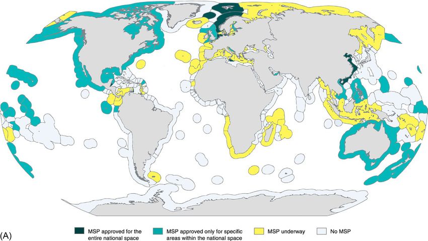
572 World Seas: An Environmental Evaluation

Reef Marine Park (GBRMP) in Australia is a “pioneering example of MSP” (Jay et al., 2013). However, as MSP spread
worldwide, it seems that its conservation foundation has in some instances become diluted (Merrie & Olsson, 2014). There
has been a perceptible shift toward an increasing need to manage conflicting maritime uses, both existing and future, espe-
cially in crowded ocean spaces and highly industrial maritime areas (Young et al., 2007).
    As the number of countries with MSP initiatives increased around the world, and MSP processes started being imple-
mented, monitored, and revised, so did the amount of MSP-related information and expertise. Scientific literature on MSP
started in the 1960s–1970s, and from 2006 onward there was a significant expansion in the number of scientific articles,
books, book chapters, reports, and academic theses on the topic (Fig. 30.1). According to Merrie and Olsson (2014), much
of this increase in academic interest in MSP seems to have derived from the first international workshop on MSP that

FIG. 30.1 Trends in marine spatial planning (MSP) related literature up to 2017. (A) Evolution of the number of scientific publications addressing MSP
per year, between 1960 and 2017, as identified in the ISI Web of Knowledge (data collected searching all databases and using the terms “marine spatial
planning,” “maritime spatial planning,” “ocean planning,” “marine planning,” “marine zoning,” “ocean zoning,” or “marine spatial management”). The
subset of results found only for “marine spatial planning” or “maritime spatial planning” is highlighted (representing c.80% of all results). For visual
purposes only, the length of the horizontal scale differs for the intervals 1960–2000 and 2000–2017. (B) Evolution of the number of articles found in
Google Scholar for each MSP-related term per year, between 2000 and 2017 (color codes as in C). (C) Total number of articles found in Google Scholar
for different MSP-related terms. Data search was performed in November 2017, thus including all results available by then.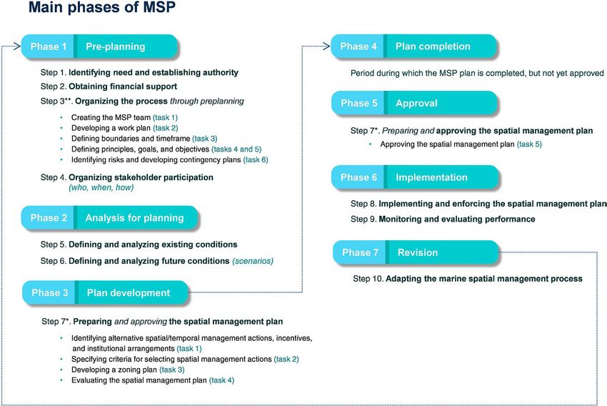
Marine Spatial Planning Chapter | 30               573

was organized by UNESCO’s Intergovernmental Oceanographic Commission (IOC) in 2006. Currently, there are over
900 scientific papers published in international peer-reviewed journals on MSP (Fig. 30.1A) and almost 10,000 articles
in Google Scholar when searching for “marine spatial planning” alone (Figs. 30.1B and C). A growing number of MSP-
specific training programs are also further stimulating MSP expertise and proficiency, for example, short courses such as
the Blue Solutions’ Blue Planning in Practice and the Duke University’s Marine Planning Advancement Training, or full
graduate programs such as the Erasmus Mundus Master Course on Maritime Spatial Planning (Università Iuav di Venezia,
University of Seville, and University of the Azores), and the Marine Spatial Planning and Management Master of Marine
Studies (Memorial University of Newfoundland) (MEAM, 2017).
    One of the best known and applied documents on MSP is the IOC-UNESCO guide entitled Marine spatial planning:
a step-by-step approach toward ecosystem-based management (Ehler & Douvere, 2009). Although MSP is a complex
process, full of intricacies, the IOC-UNESCO guide explains it in a very thorough, clear, and objective way. Therefore, the
following sections largely build on that source.

30.2.2 What Does MSP Entail?
As a planning process, MSP involves a number of key phases, steps, and tasks that should be fulfilled to ensure its effec-
tive development (Fig. 30.2). In the ideal case, MSP begins with a “preplanning” phase (Phase 1) that includes not only the
definition of planning principles, planning goals, and SMART objectives (i.e., specific, measurable, achievable, relevant,
and time bound) for a particular marine management area, but also the identification of MSP spatial and temporal boundar-
ies, and very importantly, the need for MSP. Indeed, having a clear understanding of the problems either existing or antici-
pated in the management area (e.g., conflicting uses, loss of biodiversity or services, inadequate management), and clearly

FIG. 30.2 Main phases of marine spatial planning (MSP). Phases are defined according to IOC-UNESCO (2017a), and corresponding key steps and
tasks are defined as in the UNESCO’s guide on MSP (Ehler & Douvere, 2009). Different tasks from step 7 correspond to different phases of MSP develop-
ment: tasks 1–4 are included in Phase 3, while task 5 corresponds to Phase 5. Phase 4 is not a “step” in MSP development, therefore not having any equiva-
lence in Ehler and Douvere (2009). It is instead a stage between steps, which sometimes takes place during a substantial period of time. Terminology of
step 3 might seem redundant with Phase 1. To avoid misinterpretations, tasks involved in step 3 are identified showing that they do not encompass the
entire range of action included in Phase 1. After the completion of Phase 7, a new round of planning takes place.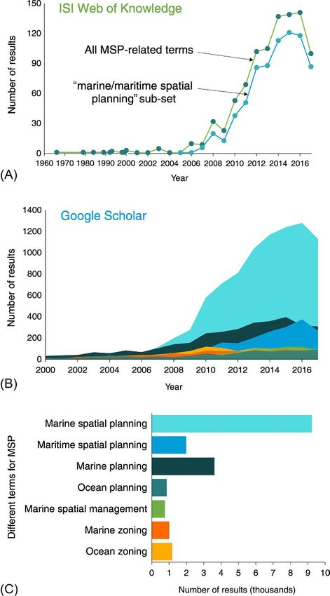
574 World Seas: An Environmental Evaluation

identifying them are aspects of paramount importance to keep the planning efforts focused and to ensure the effectiveness
of the MSP process (Büning et al., 2017). This first phase should also include the designation of an appropriate MSP au-
thority responsible for leading the process, the identification of continuing financing mechanisms, the analysis of potential
risks, and very importantly, the organization of stakeholder engagement in the process (Ehler & Douvere, 2009). An MSP
team should also be assembled and a work plan developed on how to proceed.
     Following this initial stage, “analysis for planning” should take place (Phase 2). This phase pertains to the definition
and analysis of both present and future conditions (e.g., ecological, oceanographic, socioeconomic, political), which starts
with the collection and mapping of data on existing biophysical conditions and human activities, and the subsequent iden-
tification of corresponding conflicts and compatibilities. Based on the information collected, alternative scenarios should
be developed on both the spatial and temporal needs of existing human activities, and on requirements for new demands of
ocean space. After analyzing and evaluating such scenarios a desired future spatial vision should be selected.
     When such selection occurs, the development of a spatial management plan, often designated as a “marine spatial plan,”
begins (Phase 3, “management plan development”). Here, spatially explicit management actions are identified to lead to the
desired spatial vision for the use of the ocean, and an ocean zoning scheme is developed to support the implementation of
these actions (Agardy, 2010). Zones are usually defined using a combination of maps and regulations (Büning et al., 2017)
and a number of analytical and decision support tools are available to support zoning, for example, geographic informa-
tion systems, SeaSketch, MARXAN (Agardy, 2015). In this phase of MSP, performance criteria, or indicators, should be
defined to evaluate the management actions. Concomitantly, incentives are specified to foster the implementation of such
actions, institutional arrangements (authorities and responsibilities) are identified, and the overall marine spatial plan is
evaluated (e.g., through a strategic environmental assessment).
     From this point onwards, and until approval of the marine spatial plan, MSP is in the “management plan completion”
phase (Phase 4). According to the specificities and intricacies of each management context, this phase may correspond to
a shorter or a longer period.
     Once the marine spatial plan is approved through a formal adoption process (Phase 5, “approval of the management
plan”) it should be implemented and monitored (Phase 6, “implementation of the management plan”). The latter is a criti-
cally important stage to the success of any MSP process, where not only the management actions of the plan are put in
place, but also the responsible entities should ensure compliance with plan’s requirements together with the enforcement of
the plan. A performance monitoring and evaluation program should also be developed at this stage, and corresponding data
are gathered, evaluated, analyzed, and reported (Ehler & Douvere, 2009).
     Finally, the first round of MSP development is “concluded” with the “revision, amendment, and adaptation of the
management plan” (Phase 7). In this last stage, results from monitoring and evaluation are used to adapt the elements of
the planning process in light of lessons learned, that is, through a process of adaptive management (Douvere & Ehler,
2011; Frazão Santos, Domingos, Ferreira, Orbach, & Andrade, 2014). This will ultimately result in proposals for adapting
management goals, objectives, outcomes, and strategies for the next round of planning, as well as in the identification of
research needs.

30.2.3     Benefits of Having MSP in Place
Although the concept of MSP emerged in the context of marine conservation, MSP is not the same as conservation plan-
ning. Instead of primarily focusing on establishing marine protected areas (MPAs), MSP is a multiobjective, multiuse
planning process that seeks to integrate and balance economic, social, and environmental objectives for all uses of the
ocean space (Ehler, 2012). Still, MSP may contribute to overcome some of the shortcomings of conservation planning
(Agardy, di Sciara, & Christie, 2011; Agardy et al., 2012) and networks of MPAs are often an output of the planning
process (Ehler, 2012).
    Managing conflicting maritime uses (use-use conflicts) together with conflicts between these uses and marine eco-
systems goods and services (use-environment conflicts) is exactly why MSP is most needed and a useful tool. MSP is in
effect a future-oriented process that can offer the best means to address conflicts and foster compatibilities, many times
beforehand (i.e., prior to having any activities in place). Indeed, one of the biggest “myths” of MSP is that if a marine area
does not have any problems today (e.g., because the intensity of human uses is low) MSP is not needed (Ehler, 2012). On
the contrary, as stated by Ehler “the best time to begin planning is before problems arise” (Ehler, 2012). In such context,
instead of “reacting” to events, decision makers have the chance to plan and select management actions that are expected
to lead to a desired future spatial vision for the marine area.
    According to Ehler and Douvere (2009), when properly developed MSP can produce a variety of environmental, so-
cial, and economic benefits. By reducing use-use and use-environment conflicts, MSP promotes an efficient use of marine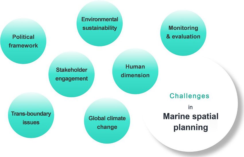
Marine Spatial Planning Chapter | 30 575
resources and space, as well as the reduction of cumulative human impacts, thereby contributing to preserving marine
ecosystem services. In addition, MSP contributes to the allocation of space for marine conservation outcomes, such as
MPAs. At the social level, MSP can improve opportunities for public and stakeholder engagement in ocean use manage-
ment. Concomitantly, it allows for the identification of cultural heritage sites, for example, and their subsequent protection.
At the economic level, one of the major benefits of MSP is increasing the certainty for private sector investments as well as
the transparency in permitting and licensing procedures. MSP also identifies compatible human uses within a marine man-
agement area, and reduces conflicts between incompatible uses (see more examples of MSP benefits in Ehler & Douvere,
2009).
30.3 GLOBAL STATUS OF MARINE SPATIAL PLANNING
Because of its potential and relevance for the implementation of operational ocean management and governance, MSP has
gained considerable importance over the last decade, and many nations worldwide have begun developing their own spatial
planning processes. As stated many times before, MSP “is an idea whose time has come” and, thus, one that ultimately
should not be resisted (e.g., Ehler, 2012; Ehler & Douvere, 2009). In fact, it has been argued that the global dimension of
MSP “reflects the international scientific and policy discourse calling for the adoption of MSP in the interests of environ-
mental integrity and sustainable use of the world’s seas and oceans” (Jay et al., 2013).
MSP is currently under development in over 66 countries around the world (IOC-UNESCO, 2017a), encompassing six
continents (Europe, Africa, Asia, Australia (Oceania), North America, and South America) and four ocean basins (Atlantic,
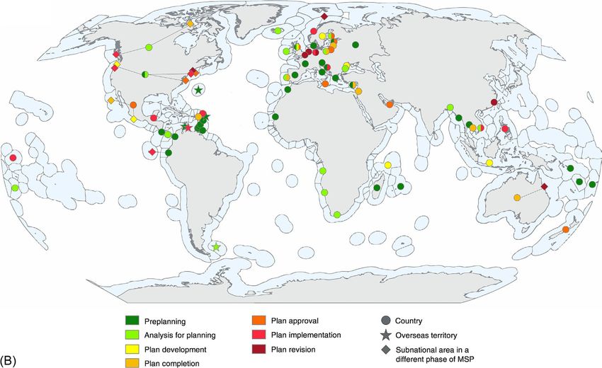
Pacific, Indian, and Arctic). Fig. 30.3 and Table 30.1 present the global status of MSP development in 2017, while Fig. 30.4
summarizes the total number of countries per geographical region and phase of MSP.
While most countries (c.70%) are still in the early phase of their MSP initiatives, others have already approved, imple-
mented, or even revised marine spatial plans (Fig. 30.4). In effect, MSP is already in place (i.e., approved by the government)
in 22 countries (Table 30.1) that together represent almost 27% of the world’s exclusive economic zones (EEZs) (EEZs
percentages are calculated based on information from Claus et al. (2017) excluding overseas territories, except when they
are expressly mentioned in Table 30.1). These include Belgium, Germany, the Netherlands, Norway, China, and Belize,
where MSP covers the majority of the maritime space by focusing on their EEZ and/or territorial sea (TS), but also countries
where MSP is in place just for a particular area under national jurisdiction, such as a province, a municipality, or a state, for
example, United States, Canada, and Croatia (see Table 30.1). The additional 44 countries where MSP is currently under
development (and that make up for an additional c.26% of the world’s EEZs) are expected to have their MSP processes ap-
proved in the coming years. Countries with marine spatial plans already completed and pending approval will probably have
MSP in place in the near future, including Member States of the European Union (EU) that must have marine spatial plans
approved by 2021 to comply with the European Directive on MSP (European Commission, 2014). This means that around
2030, a key date for the conservation and sustainable use of the oceans (see United Nations’ Sustainable Development Goal
14), MSP will be in place in over half of the world’s EEZs, that is, the ocean space under national sovereignty.
From a regional perspective, Europe and the Americas are the regions with the greatest number of countries and terri-
tories working on MSP—namely 37% and 28% of all countries and territories, respectively (Fig. 30.4). This prevalence of
Europe and the Americas is also valid for every phase of MSP development as these two regions encompass approximately
three-quarters of countries/territories in each phase. On the contrary, in the Middle East only two countries (3%) are cur-
rently developing MSP, both in an intermediate phase of the process. In Africa, MSP initiatives, particularly in Angola,
Namibia, and South Africa, essentially covering the Benguela Current large marine ecosystem, are recent and in their early
stages (11% of countries), while in both Oceania and Asia (10% and 11%, respectively) MSP is found from preplanning to
revision stages (Fig. 30.4).
At the national level, prominent maritime nations such as Norway and China are leading the way on MSP development
(Ehler, 2013). The following sections provide an overview on national initiatives per geographical region. For detailed
information on individual national MSP processes, visit the IOC-UNESCO website on MSP around the world (IOC-
UNESCO, 2017b), the European MSP platform (European Commission, 2017), reviews from Jay et al. (2013), Collie et al.
(2013), Agardy et al. (2012), and Douvere and Ehler (2009a, 2009b), or specific scientific literature identified in Table 30.1.
30.3.1 Europe
In Europe, several countries have had MSP in place for about a decade and are currently in the second or third round of
planning. Norway is one of these countries, where three marine spatial plans cover the entire EEZ of over 2 million km2:
the Barents Sea-Lofoten Area plan (approved and implemented in 2006 and first updated in 2011), the Norwegian Sea plan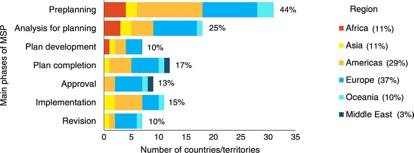
576 World Seas: An Environmental Evaluation

FIG. 30.3 Global status of marine spatial planning (MSP) development in 2017. (A) Exclusive economic zones (EEZs) of countries where: MSP is ap-
proved for the entire national space; MSP is approved only for a specific marine area within the country (e.g., province, municipality, state, etc.); MSP is
under development; or, no MSP is being carried. Map is based on information from Table 30.1. (B) Phase of MSP development by country (circle shapes)
and overseas territory (star shapes) identified in Table 30.1. Particular subnational areas that are in a different phase of MSP development (diamond
shapes) are also identified. Some countries include more than one phase of MSP development (multicolor shapes).
Marine Spatial Planning Chapter | 30                 577

TABLE 30.1 Global Status of Marine Spatial Planning (MSP) Development in 2017
                                                                                                          Examples of Scientific
Country/Territory      Phase of MSP Development (Number and              Names of Completed               Publications on
(Per Region)           Description)                                      Marine Spatial Plans             National MSP Initiatives
Europe

Belgium (EEZ and TS)   7              Revision                           Maritime Spatial Plan for        Douvere, Maes, Vanhulle,
                                                                         the Belgian Part of the          and Schrijvers (2007),
                                                                         North Sea                        Douvere and Ehler
                                                                                                          (2009a, 2009b)

Bulgaria               2              Analysis for planning              N/A

Croatia                1 and 6        Preplanning, except for            Zadar County Integrated
                                      Zadar county where sea             Sea Use and Management
                                      use management plan is             Plan
                                      implemented

Cyprus                 1 and 4        Preplanning, except for Limassol   Pilot Plan for Coastal and       Hadjimitsis et al. (2016)
                                      district where a nonlegally        Marine Area of the District
                                      binding pilot plan is completed    of Limassol

Denmark                1              Preplanning                        N/A

Estonia                1 and 5        Preplanning, expect for Hiiumaa    Hiiu Island MSP Pilot Plan;
                                      Island and Pärnu Bay areas         Pärnu Bay MSP Pilot Plan
                                      where pilot plans are approved

Finland                2 and 5        Analysis for planning, except      Regional Land Use Plan
                                      for Kymenlaakso Region where       for the Sea, Kymenlaakso
                                      land-use plan for the TS is        Region
                                      approved

France                 1              Preplanning                        N/A

Germany (EEZ and       6–7            Implementation, except for         Maritime Spatial Plan for        Jay, Alves, et al. (2016),
TS)                                   coastal states of Mecklenburg-     the EEZ of the Baltic Sea;       Jay, Klenke, and Janßen
                                      Vorpommern and Lower Saxony        Maritime Spatial Plan for        (2016), Kannen (2014)
                                      where spatial plans are revised    the EEZ of the North Sea;
                                                                         State Development Plan for
                                                                         Schleswig-Holstein; Spatial
                                                                         Development Programme
                                                                         of Mecklenburg-
                                                                         Vorpommer; Spatial
                                                                         Planning Programme of
                                                                         Lower Saxony

Greece                 1              Preplanning                        N/A                              Papageorgiou (2016),
                                                                                                          Tsilimigkas and Rempis
                                                                                                          (2017)

Iceland                2              Analysis for planning              N/A

Ireland                2              Analysis for planning              N/A

Italy                  1              Preplanning                        N/A

Latvia (EEZ)           4              Plan completion (approval          Draft Maritime Spatial Plan      Veidemane et al. (2017)
                                      expected in 2017)                  for the internal marine
                                                                         waters, territorial waters and
                                                                         exclusive economic zone of
                                                                         the Republic of Latvia

Lithuania (EEZ and     5              Approval                           Comprehensive Plan of the
TS)                                                                      Republic of Lithuania

                                                                                                                              Continued
578 World Seas: An Environmental Evaluation
TABLE 30.1 Global Status of Marine Spatial Planning (MSP) Development in 2017—cont’d
Examples of Scientific
Country/Territory Phase of MSP Development (Number and Names of Completed Publications on
(Per Region) Description) Marine Spatial Plans National MSP Initiatives
Malta (marine area 5 Approval Strategic Plan for
up to 25 nm) Environment and
Development
Netherlands (EEZ) 7 Revision Policy Document on the Douvere and Ehler
North Sea 2016–2021 (2009a, 2009b); Platjouw
(2018)
Norway (EEZ and TS) 6–7 Implementation, except for Integrated Management Ehler and Douvere
Barents Sea where integrated Plan for the Marine (2010); Platjouw (2018)
management plan is revised Environment of the
Barents Sea−Lofoten Area;
Integrated Management
Plan for the Marine
Environment of the
North Sea and Skagerrak;
Integrated Management
Plan for the Marine
Environment of the
Norwegian Sea
Poland 2 and 4 Analysis for planning, except for Pilot Maritime Spatial Plan Zaucha (2012, 2014)
the Gulf of Gdańsk, Pomeranian for the Western Part of
Bight/Arkona Basin and the Gulf of Gdańsk; Pilot
Southern Middle Bank where Maritime Spatial Plan for
three nonbinding MSP plans are Pomeranian Bight/Arkona
completed Basin; Pilot Maritime
Spatial Plan for the
Southern Middle Bank
Portugal 2 and 4 Analysis for planning, except “POEM” Marine Spatial Ferreira et al. (2016),
for the continental part of the Plan Frazão Santos et al.
EEZ where a nonbinding pilot (2015)
project is completed
Romania 3 Plan development N/A
Russia 2 Analysis for planning N/A Andrey and Larisa (2015)
Slovenia 1 Preplanning N/A
Spain 1 Preplanning N/A Rodríguez-Rodríguez
et al. (2016), Vivero and
Mateos (2012)
Sweden 3 Plan development N/A
United Kingdom 1–5 Preplanning to approval East Inshore and East Kelly et al. (2014), Smith
(EEZ and TS) Offshore Marine Plans and Jentoft (2017)
(England); South Inshore
and South Offshore Marine
Plans (England); Scotland’s
National Marine Plan;
Marine Plan for Northern
Ireland; Welsh National
Marine Plan
The Americas
Antigua and Barbuda 6 Implementation Barbuda Marine Zoning
(only Barbuda Plan
coastal waters)Marine Spatial Planning Chapter | 30 579
TABLE 30.1 Global Status of Marine Spatial Planning (MSP) Development in 2017—cont’d
Examples of Scientific
Country/Territory Phase of MSP Development (Number and Names of Completed Publications on
(Per Region) Description) Marine Spatial Plans National MSP Initiatives
Belize (TS) 6 Implementation Belize Integrated Coastal Arkema et al. (2015)
Zone Management Plan
Bermuda (United 1 Preplanning N/A Lester et al. (2017)
Kingdom)
Bonaire (the 6 Implementation Bonaire National Marine
Netherlands) Park Management Plan
Canada (EEZ and TS) 2 and 4 and 6 Analysis for planning, except Haida Gwali Marine Plan; Flannery et al. (2016),
for the Pacific North Coast North Coast Marine Plan; Gunton and Rutherford
where four subregional MSP Central Coast Marine Plan; (2010)
plans are implemented, and North Vancouver Island
Nnunavut where a land use plan Marine Plan; Nunavut Land
is completed (approval expected Use Plan
in 2017)
Colombia 1 Preplanning N/A Mow et al. (2007)
Costa Rica (only Gulf 1 Preplanning N/A
of Nicoya)
Curaçao (the 1 Preplanning N/A
Netherlands)
Dominica 1 Preplanning N/A
Ecuador 1 and 6 Preplanning, except for the Galapagos Marine Reserve Castrejón and Charles
Galapagos marine reserve where Management Plan (2013)
zoning plan is Implemented
Falkland Islands 2 Analysis for planning N/A
(United Kingdom)
Grenada 1 Preplanning N/A
Mexico (EEZ and TS) 3–5 Plan development to approval Ocean Use Plan for the Díaz-de-León and Díaz-
Gulf of California; Ocean Mondragón (2013)
Use Plan for the Gulf of
Mexico and Caribbean Sea;
Ocean Use Plan for the
Northern Pacific
Montserrat (United 1 Preplanning N/A
Kingdom)
Panama (Gulf of 2 Analysis for planning N/A
Montijo)
Saint Kitts and Nevis 4 Plan completion Pilot Marine Zoning Plan Agostini et al. (2015),
(EEZ) for Saint Kitts and Nevis Schill et al. (2011)
Saint Lucia 1 Preplanning N/A
St Vincent and the 1 Preplanning N/A
Grenadines
Trinidad and Tobago 1 Preplanning N/A
(only northwest coast
of Trinidad)
Continued580 World Seas: An Environmental Evaluation
TABLE 30.1 Global Status of Marine Spatial Planning (MSP) Development in 2017—cont’d
Examples of Scientific
Country/Territory Phase of MSP Development (Number and Names of Completed Publications on
(Per Region) Description) Marine Spatial Plans National MSP Initiatives
The United States of 1–7 Preplanning to revision Northeast Ocean Plan; Bates (2017), Gopnik
America (EEZ and TS) Mid-Atlantic Regional et al. (2012)
Ocean Action Plan;
Massachusetts Ocean
Management Plan; Rhode
Island Ocean Special Area
Management Plan; Oregon
Territorial Sea Plan; Draft
Marine Spatial Plan for
Washington’s Pacific Coast
Oceania
Australia (EEZ, 4 and 7 Plan completion, except for Great Barrier Reef Marine Kenchington and Day
including Norfolk Great Barrier Reef Marine Park Park Zoning Plan 2003; (2011), Vince (2014)
Island) where zoning plan is revised Marine Bioregional Plan
for the South-west Marine
Region; Marine Bioregional
Plan for the North-west
Marine Region; Marine
Bioregional Plan for the
North Marine Region;
Marine Bioregional Plan
for the Temperate East
Marine Region; South-east
Regional Marine Plan
Fiji 1 Preplanning N/A
Kiribati (only 6 Implementation Phoenix Islands Protected
Phoenix Islands) Area (PIPA) Management
Plan, 2010–2014
New Zealand (only 5 Approved Hauraki Gulf Marine Scott (2016)
Hauraki Gulf) Spatial Plan
Solomon Islands 1 Preplanning N/A
Tonga 2 Analysis for planning N/A
Vanuatu 1 Preplanning N/A
Asia
Bangladesh 2 Analysis for planning N/A
Cambodia (only 4 Plan completion Coastal Use Zoning
Sihanoukville Plan for Province of
Province) Sihanoukville
China (EEZ and TS) 7 Revision National Marine Functional Mu et al. (2013), Lu et al.
Zoning, Year 2011–2020 (2015)
Indonesia 3 Plan development N/A
Myanmar 1 Preplanning N/A
Philippines (only 6 Implementation Batangas Bay Water Zoning
Bataan Province) Pilot Project
Thailand (only Trat 1 Preplanning N/A
Province)Marine Spatial Planning Chapter | 30 581
TABLE 30.1 Global Status of Marine Spatial Planning (MSP) Development in 2017—cont’d
Examples of Scientific
Country/Territory Phase of MSP Development (Number and Names of Completed Publications on
(Per Region) Description) Marine Spatial Plans National MSP Initiatives
Vietnam (TS) 2 and 6 Analysis for planning, except Danang Master Plan
for Danang Municipality where Towards 2030
zoning plan is implemented
Middle East
United Arab Emirates 5 Approval The Plan Maritime 2030:
(only Abu Dhabi Abu Dhabi Coastal and
marine area) Marine Framework Plan
Israel (EEZ) 4 Plan completion Israel Marine Plan Portman (2015)
Africa
Angola 2 Analysis for planning N/A
Madagascar 1 Preplanning N/A Allnutt et al. (2012)
Mauritania 1 Preplanning N/A
Mauritius 1 Preplanning N/A
Morocco 1 Preplanning N/A
Namibia 2 Analysis for planning N/A
Seychelles 3 Plan development N/A
South Africa 2 Analysis for planning N/A
The status of MSP development for each country/territory is based on information from IOC-UNESCO (2017a, 2017b), European Commission (2017) and
particular scientific references on national MSP initiatives. Designations of completed marine spatial plans are also presented. Countries are presented in
alphabetical order, by region. EEZ, exclusive economic zone; TS, territorial sea; N/A, not applicable.
FIG. 30.4 Number of countries with marine spatial planning (MSP) initiatives in 2017, per main phase of MSP development and geographical region.
Percentages are based on the total number of countries with MSP in place or underway, that is, 66. Percentages per main phase of MSP do not sum up to
100%, as some countries have more than one phase of MSP development. Diagram is based on information from Table 30.1.
(approved in 2009 and implemented), and the North Sea and Skagerrak plan (approved in 2013 and implemented) (IOC-
UNESCO, 2017b). Norway’s marine spatial plans are very comprehensive and establish guidelines for management actions
across economic sectors (including fisheries) together with actions for the conservation and sustainable use of its marine
areas (IOC-UNESCO, 2017b). In Belgium, MSP has also been in place for over a decade—Belgium was one of the first
nations to have an operational MSP system in place. Its initial master (zoning) plan was completed and implemented in
2003 to manage its intensively used EEZ of only c.3500 km2, and in 2014 Belgium approved a new, legally binding marine582 World Seas: An Environmental Evaluation
spatial plan (IOC-UNESCO, 2017b). Belgium MSP addresses the management of human uses within nature protection
zones and MPAs, together with offshore wind development (European Commission, 2017). The Netherlands is also an
MSP “pioneer.” With one of the most intensively used ocean spaces in the world (EEZ of c.65,000 km2), it completed its
first marine spatial plan in 2005, which was further revised and adapted in both 2009 and 2015 (European Commission,
2017). The Netherlands MSP process started not only due to a need for integrated spatial planning because of new uses
requiring ocean space, primarily offshore wind farms and protected areas, but also due to potential growth in existing uses
(IOC-UNESCO, 2017b). Finally, in Germany MSP has been developed at two levels: the EEZ level, since 2009, when
two regulatory and enforceable marine spatial plans were approved for both the Baltic Sea and the North Sea parts of the
German EEZ (c.57,000 km2), and the state (länder) level where authority to manage the TS resides. Three legally binding
marine spatial plans are in place for the three länders: the Mecklenburg-Vorpommern plan (approved in 2005 and revised in
2016), the Lower Saxony spatial planning program (approved in 2008 and amended in 2012), and the Schleswig-Holstein
plan (approved in 2010 and currently under revision). MSP in Germany is primarily focused on planning for offshore wind
farms and shipping (European Commission, 2017).
Other European countries are less advanced in MSP development. In Malta, a Strategic Plan for Environment and
Development that provides a framework policy for the use of land and sea was approved by parliament in 2015, but is yet to
be implemented (European Commission, 2017). In Lithuania, a mandatory marine spatial plan, developed as an extension
of the national terrestrial spatial plan, was also approved by parliament in 2015 (European Commission, 2017). In Latvia,
the first draft marine spatial plan for the EEZ was completed in 2016, and government approval is expected soon (European
Commission, 2017). The United Kingdom is at various stages of MSP development, according to different marine zones:
England has 11 inshore/offshore planning areas where marine plans are being developed on a sequential basis (the East
Inshore and East Offshore plans were approved in 2014, and the South Inshore and South Offshore plans were completed in
2016; remaining plans are to be in place by 2021); Scotland has a national marine spatial plan, approved since 2015, which
is to be supplemented by 11 regional plans providing detailed guidance for the TS; marine spatial plans for Northern Ireland
and Wales are currently under development (European Commission, 2017).
In Croatia, Finland, Estonia, Poland, Cyprus, and Portugal, MSP processes at the national level are at their early stages.
However, in all cases marine spatial plans have been further developed at the local level: Croatia has already implemented
a legally binding integrated sea use management plan (focused on aquaculture) for the Zadar county; Finland has a regional
land-use plan for the marine waters (TS) of the Kymenlaakso Region approved in 2014; Estonia has two approved marine
spatial pilot projects, one for the area around the Hiiumaa Island (adopted in 2016) and another for the Pärnu Bay (adopted
in 2017); Poland has three nonbinding marine spatial pilot plans already completed (the Gulf of Gdańsk plan, developed
in 2008 and published in 2010, and the Pomeranian Bight/Arkona Basin plan and the Southern Middle Bank plan, both
developed between 2009 and 2011); Cyprus has a nonbinding marine spatial pilot plan for Limassol area completed in
2015; and Portugal has a nonbinding marine spatial pilot project for the continental part of its EEZ completed in 2012
(European Commission, 2017). Remaining European countries—Bulgaria, Denmark, France, Greece, Iceland, Ireland,
Italy, Romania, Russia, Slovenia, Spain, and Sweden—have MSP processes in earlier stages of development, that is, “pre-
planning” to “plan development” (Table 30.1). However, all that are EU Member States must have their marine spatial plans
implemented by 2021 (European Commission, 2014).
30.3.2 The Americas
Canada (the seventh largest EEZ in the world) began its MSP initiatives in 2008, with the development of five strategic
plans for five Large Ocean Management Areas (the Pacific North Coast Integrated Management Area, Beaufort Sea, Gulf
of St. Lawrence, Eastern Scotian Shelf, and Placentia Bay/Grand Banks), encompassing almost 6 million km2 of ocean area.
However, none of these plans have been implemented. From 2011 to 2016 MSP did move forward in Canada when the
Marine Plan Partnership for the Canadian Pacific North Coast (MaPP) developed and approved four sub-regional marine
spatial plans for the Pacific North Coast region (Haida Gwaii, the North Coast, the Central Coast, and North Vancouver
Island), together with a regional implementation plan in 2016. A land-use plan covering marine areas of the northernmost
territory of Nunavut (c.1 million km2 of marine waters) was completed in 2016, and its approval is expected in 2018 (IOC-
UNESCO, 2017b).
The United States, with the second largest EEZ in the world (over 11 million km2), is also experienced in MSP develop-
ment. Here, MSP is taking place at two main levels: the federal level, where nonregulatory regional marine spatial plans
are to be developed for the EEZ; and the state level, where regulatory marine spatial plans are developed for state waters
within three nautical miles from shore (IOC-UNESCO, 2017b). For the EEZ, nine regional planning areas are considered:
Northeast, Mid-Atlantic, South Atlantic, Gulf of Mexico, Caribbean, West Coast, Alaska/Arctic, Pacific Islands, and theMarine Spatial Planning Chapter | 30 583
Great Lakes. In 2016, two nonregulatory regional plans were completed and approved: the Northeast Ocean Plan (EEZ
and state waters of Maine, Vermont, New Hampshire, Massachusetts, Connecticut, and Rhode Island) and the Mid-Atlantic
Regional Ocean Action Plan (EEZ and state waters of New York, Pennsylvania, New Jersey, Delaware, Maryland, and
Virginia). At the state level, four states have MSP processes that are further developed, some being already in place for
years: Massachusetts (regulatory marine spatial plan approved in 2009 and amended in 2015), Rhode Island (regulatory
marine spatial plan approved and implemented in 2010, and currently being updated), Oregon (regulatory plan for the TS
adopted in 1994, and amended in 2013 to incorporate a renewable energy section), and Washington (draft regulatory plan
available and expected to be implemented in 2018). Remaining regional and state-level MSP initiatives are still in their
early stages, for example, in Alaska and the US Gulf of Mexico.
Mexico, another large maritime nation (EEZ with over 3 million km2), started addressing MSP in 2003 and devel-
oped four regional marine spatial plans, one for each marine planning region: the Gulf of California plan (completed
and approved in 2006), the Gulf of Mexico and Caribbean Sea plan (completed and approved in 2012), the Northern
Pacific plan (completed in 2015 and pending approval), and the Central Southern Pacific Ocean plan (expected to be
completed by 2018).
Four other countries/territories have MSP in place in the Americas: Belize, Antigua and Barbuda, Ecuador, and Bonaire
(the Netherlands). Belize has been carrying out coastal and ocean planning for over a decade, both at the level of the entire
barrier reef and at local scales (Arkema et al., 2015). Such efforts resulted in the approval and endorsement of an integrated
coastal zone management plan in 2016, which includes the TS and much of the EEZ (IOC-UNESCO, 2017b). In Antigua
and Barbuda, a zoning plan was approved and implemented in 2014, with technical support from the Blue Halo Initiative,
but limited to coastal waters (within 3 nautical miles) around Barbuda. In Ecuador, MSP is in place for almost two decades
in the Galapagos Marine Reserve, where a zoning plan was approved in 2000 and implemented in 2006 (Castrejón and
Charles, 2013). For the continental part of the Ecuadorian EEZ, however, MSP is still in its early stages (IOC-UNESCO,
2017b). Finally, in Bonaire MSP has also been in place since 2006, when a management plan was completed for the Bonaire
National Marine Park (first established in 1979), which includes the entire marine waters of the island; a corresponding
zoning plan was implemented in 2010.
MSP in Saint Kitts and Nevis is also further advanced, although not yet approved: a pilot zoning plan, developed
within a multi-objective, integrated approach, was completed in 2010 for the nation’s coastal waters with support from The
Nature Conservancy (Agostini et al., 2010). Remaining countries and territories in the Americas—Colombia, Costa Rica
(Gulf of Nicoya), Dominica, Grenada, Panama (Gulf of Montijo), Trinidad and Tobago, Saint Lucia, Saint Vincent and the
Grenadines, Bermuda (United Kingdom), Curaçao (the Netherlands), Falkland Islands (United Kingdom), and Monserrat
(United Kingdom)—all have MSP processes in their early developing stages (Table 30.1).
30.3.3 Oceania
Many advocate that important lessons can be drawn from the long-standing experience of MSP and sea-use manage-
ment in Australia, namely in the GBRMP, where a zoning plan was first prepared in 1981 (Day, 2002) and approved and
implemented in 1987 (IOC-UNESCO, 2017b). Such lessons include the appropriate establishment of objectives based on
a clear understanding of the problems to be solved by MSP, as well as the need to conduct MSP in a continuous and adap-
tive manner, engaging stakeholders in the process and ensuring sustainable financing (Kenchington & Day, 2011). The
original zoning plan of the Marine Park was further revised and adapted in 2003, and corresponding 5-year outlook reports
(examining progress in protecting the Great Barrier Reef by assessing its condition, use, management effectiveness, etc.)
were published in 2009 and 2014 (IOC-UNESCO, 2017b). Concomitantly, a lesser known MSP process in Australia—
Marine Bioregional Plans (MBPs)—started with the development of the Australia’s Oceans Policy from 1998 (Vince,
2014). Several nonbinding regional marine plans (RMPs) began being developed for the entire EEZ of Australia (c.8 mil-
lion km2, not including dependent territories). However, only one was completed: the Southeast Regional Marine Plan in
2004. RMPs were replaced with MBPs after the ocean policy first review, where its focus changed from a broad multiple
use perspective to an environmental one (Vince, 2014). Accordingly, in 2012 Australia has completed four MBPs for the
Southwest, Northwest, North and Temperate East marine regions (IOC-UNESCO, 2017b).
In Oceania, New Zealand and Kiribati are the only other countries where MSP is further developed, as Fiji, Solomon
Islands, Tonga, and Vanuatu are still in the early stages of MSP (see Table 30.1). However, in both cases MSP is only in
place for a particular area within the EEZ. In New Zealand, it is limited to the Hauraki Gulf Marine Park, where a marine
spatial plan was completed and approved in 2016 (IOC-UNESCO, 2017b). In Kiribati, MSP pertains essentially to the
Phoenix Islands Protected Area (PIPA) where a management plan, including a zoning map, is approved and implemented—
the plan was published in 2009 (IOC-UNESCO, 2017b).584 World Seas: An Environmental Evaluation
30.3.4 Asia
China is another country where MSP started 30 years ago, and the one in Asia where MSP is most developed. The idea
of “marine functional zoning” was first proposed in China in 1988, in 2002 its first National Marine Zoning Plan was ap-
proved and implemented, and in 2004 marine zoning started being approved for coastal provinces, autonomous regions,
and municipalities (Feng et al., 2016). In 2010, a new round of planning took place, and as a result, in 2012 China formally
approved a revised version of its marine spatial plan—the National Marine Functional Zoning, Year 2011–2020 (IOC-
UNESCO, 2017b). China also has an “eco-environmental redlining” process to identify, delineate, and create zones to
protect areas of high concentration of ecosystem services, which is now being “superimposed” on the existing marine plans
(Wang et al., 2015).
In the Philippines, MSP is in place only at the municipal level. A marine zoning pilot project was developed in 1999
for the Batangas Bay area, focused on the resolution of multiple use conflicts, and a municipal integrated land and sea-use
zoning plan was adopted in 2006, after being developed with support from the Partnership for Environmental Management
of Seas of East Asia (PEMSEA). In Cambodia, MSP is also only developed at the municipal level in the Sihanoukville
Province, where a coastal use zoning scheme was approved in 2005 (IOC-UNESCO, 2017b). In Vietnam, MSP is underway
for eight coastal provinces, encompassing its TS, in the context of a government project on coastal sustainable development
with the support of the World Bank. Here, although most provinces are still in an “analysis for planning” phase, a zoning
plan for marine and coastal areas was approved for the Danang Municipality in 2010 (IOC-UNESCO, 2017b). Other Asian
countries—Bangladesh, Indonesia (East Kalimantan Province), Thailand (Trat Province), and Myanmar—also have MSP
underway, but still in its early stages (Table 30.1).
30.3.5 Middle East
In the Middle East, only two countries are currently developing MSP. In the United Arab Emirates, MSP was started in 2013
for the maritime area of the Emirate of Abu Dhabi, focusing on the development of a MSP framework plan (the spatial plan)
and its implementation plan. These plans were completed and approved in 2016, and MSP implementation is now under-
way. In Israel, a pilot marine spatial plan covering the entire EEZ was completed in 2015. It was an academic initiative led
by the Technion—Israel Institute of Technology, and was developed with the engagement of many stakeholders, including
national governmental representatives.
30.3.6 Africa
In Africa, MSP is underway in eight countries, being in all cases in its early stages (Table 30.1). In Morocco, Mauritania,
Madagascar, and Mauritius, discussions on MSP have indeed just begun at the national level. In Angola and Namibia,
national MSP started in 2016 as part of a larger marine management and governance program—the Marine Spatial
Management and Governance Program (MARISMA)—with financial and technical assistance from the Deutsche
Gesellschaft für Internationale Zusammenarbeit (IOC-UNESCO, 2017b). This transboundary arrangement—which also
includes South Africa—resulted from a collaborative approach among these three countries, made possible by the inter-
governmental Benguela Current Commission (BCC, 2017). In South Africa, planning started in 2015 with the development
of an MSP framework that identified four marine spatial plans covering the entire EEZ, to be completed by 2021. A bill
authorizing MSP is now in the Parliament of South Africa. Finally, in Seychelles, a government-led MSP initiative was
started in 2014 and is being developed with the support of The Nature Conservancy and The Nature Conservancy-Canada
to achieve a regulatory marine spatial plan for the EEZ and TS by 2020.
30.4 MAJOR CHALLENGES FACED IN MARINE SPATIAL PLANNING
Most of the existing MSP-related literature (Fig. 30.1) focuses on the analysis of MSP case studies as well as on the discus-
sion of challenges (present and future, conceptual and operational) that are linked to the development of MSP. For example,
the Convention on Biological Diversity report on MSP (Agardy et al., 2012) lists a number of challenges in implementing
MSP together with means to overcome them. Although differences are found across distinct biophysical, social, economic,
and political contexts, some challenges seem to be more striking and widespread. These include shortcomings in political
and institutional frameworks, challenges in balancing economic development and marine ecosystem conservation, difficul-
ties in ensuring proper monitoring and evaluation, constraints in engaging stakeholders, finding ways to encompass human
and social dimensions in MSP, addressing transboundary issues, and adapting to global environmental change (Fig. 30.5).Marine Spatial Planning Chapter | 30 585
FIG. 30.5 Prominent challenges linked to the development of marine spatial planning that are addressed in this chapter.
Dealing and responding to each of these challenges is key to ensure the long-term suitability and sustainability of MSP.
In the following sections, each of them is further presented together with primary recommendations to respond to it.
30.4.1 Political and Institutional Frameworks
The analysis of policy, governmental and institutional frameworks in the context of any marine region at any scale is
critical to the success of corresponding MSP initiatives. According to Olsen et al. (2014), an MSP initiative should
be based on a comprehensive understanding of the traditions and structures of the existing governmental system. This
is important because “governments hold the primary power and responsibility over the content of an MSP. However,
to varying degrees markets and the desires and values of civil society influence the MSP process and its contents
(…) [and this] relative influence (…) [depends] upon the governance traditions and the institutions by which influ-
ence and authority are exercised” (Olsen et al., 2014). Indeed, MSP is never properly implemented, let alone revised
and adapted, if the institutional and governmental frameworks do not support the initiative, or if they are susceptible
to undue influence from particular sectors. As a consequence, in many marine and coastal management initiatives,
“policy cycles,” that is, the sequence of actions that characterize the development of an initiative, are never fully com-
pleted (Olsen et al., 2014). Instead, management processes end up consisting of a number of portions of unconnected
cycles. This is the case of MSP in Canada, for example, where in 2008 an integrated management plan for the Eastern
Scotian Shelf was completed but never approved by the Department of Fisheries and Oceans, and in 2011 the federal
government withdrew from an agreement with the Province of British Columbia and Coastal First Nations to fund the
Pacific North Coast Integrated Management planning process, following aggressive lobbying by the marine shipping
and oil and gas sectors (Ehler, 2013). It is also the case of Portugal, where in 2012, after 4 years of work by an inter-
ministerial commission to develop the first national MSP initiative, the completed marine spatial plan ended up being
acknowledged as a “baseline study” and further substituted by a new planning initiative (Frazão Santos, 2016). This
disruption or abandonment of planning initiatives can lead to a number of problems, such as the delaying of the entire
planning process, the lack of credibility of responsible entities, the disengagement of stakeholders, and ultimately,
the absence of essential MSP management actions and marine spatial plans (Frazão Santos, 2016). Fragmentation
and mismatches in current governance of marine resources is in fact widespread and difficult to overcome (Crowder
et al., 2006). However, entities responsible for leading the MSP process must overcome the institutional resistance
to change (Crowder et al., 2006). The analysis of performance of governance (Lieberknecht et al., 2013), together
with the analysis of policy cycles (Olsen et al., 2014) allow for the identification of factors that enable or hinder the
transition from the development and formal approval of MSP, to the success or failure of its implementation, and are
therefore of the utmost importance to overcome policy-driven constraints and to ensure the proper development of
MSP processes.586 World Seas: An Environmental Evaluation
30.4.2 Environmental Sustainability and Ecosystem-Based Management
Ensuring the right balance between socioeconomic development and environmental protection is one of the major chal-
lenges for MSP. MSP has been long acknowledged as a fundamental process for the sustainable development of marine and
coastal areas (European Commission, 2007, 2010) and a practical way to support the ecosystem-based management ap-
proach (Ehler & Douvere, 2007; Douvere, 2008). However, many of the current MSP processes are more about the growth
of blue economy rather than really balancing conservation and development objectives. In these cases, marine conservation
is often perceived as just “another” spatial use of the ocean—being treated at the same level as fisheries, shipping, renew-
able energy, etc.—and the balance is heavily weighted toward economic development (Qiu & Jones, 2013), with a real risk
of social and economic factors overshadowing the importance of environmental conservation (Frazão Santos et al., 2014).
It is important to note that the process of allocating ocean space, which is the core of MSP, may or may not entail the
development of new conservation measures (e.g., establishing new protected areas, conducting new environmental assess-
ments) within the planning area. Ideally, these two aspects, that is, spatial planning and conservation, should be developed
together. However, many times there are no attempts to address actual conservation instruments and regimes in addition to
the spatial allocation of maritime activities. Indeed, in some cases conservation is at best just another “weak voice” at the
decision-making table, and limited to the inclusion of opportunistic MPAs (not designed to maximize biodiversity protec-
tion or maintain ecosystem health) in the marine management area. This is partly because MSP processes do not usually
create new authorities and responsibilities for the conservation realm, leaving them instead to the already legislatively cre-
ated entities that govern each sector (fisheries, oil and gas, water quality, shipping, etc.), which unfortunately are usually
not well integrated with each other in the development of conservation approaches.
In Europe, for example, the EU legal framework on MSP opted for a “maritime” approach to spatial planning, view-
ing its MSP primarily as an opportunity for economic growth, framed within EU’s blue growth strategy. Drawing on the
analysis of four MSP efforts around Europe, Jones et al. (2016) highlight that “the current ‘blue gold rush’ is undermining
the achievement of GES [good environmental status],” and that “real-world MSP’ing (…) as opposed to some of the more
idealistic theoretical concepts underpinning discussions in the academic literature (…) is arguably more about political
expedience than it is about conceptual ideals of proactive, consensual, and ecosystem-based approaches.”
Still, in some MSP initiatives ensuring ecosystems health is the priority, and ecosystem goods and services are the
basis, or foundation, of the entire planning process (Qiu & Jones, 2013). These “ecosystem-based” MSP processes begin
by developing a “plan for conservation”—that is, establishing how to manage human uses so as to maintain biodiversity
and ecosystem processes to the maximum extent possible—and only then move on to the spatial and temporal allocation
of different uses in the same ocean space. Ecosystem-based MSP should therefore be based on a deep understanding of
ecological processes, functions, interconnectivity, and the delivery of services and thus values. In this context, marine
scientists can play a major role in providing information and guidance to marine planners. Similarly, ecosystem services
identification, assessment, and valuation will be key for informing MSP that is environmentally sustainable (Agardy, 2015;
White et al., 2012).
Discussions on the role of marine conservation in MSP are far from being resolved, as there is a plethora of different
interpretations on the topic, and no common approaches (Kyriazi et al., 2013). Yet, broad recommendations to address this
challenge include further placing marine goods and services in a central position within the planning process (Kyriazi et al.,
2013), adopting adaptive approaches to MSP (Frazão Santos et al., 2014), and developing critical analyses of MSP case
studies where they are compared with, and analyzed for consistency with, MSP ideal concepts (Jones et al., 2016).
30.4.3 Performance Monitoring and Evaluation
Monitoring and evaluation are two of the most important phases of MSP. Indeed, as stated in the IOC-UNESCO guide on
evaluating marine spatial plans (Ehler, 2014a) “without knowing what it is that existing marine spatial plans are achieving
(or not achieving), how will it be possible to improve them the second time around?” These two phases are the “vehicles”
that allow responsible entities to learn about the effects of planning and management actions, and to further adjust and adapt
them accordingly (Laffoley et al., 2004). In particular, monitoring and evaluating MSP “performance,” that is, assessing the
effects of management actions, are especially important as they allow responsible entities to establish if observed changes
in the managed system are due to MSP actions or due to other factors (Douvere & Ehler, 2011). Some of the challenges
that performance monitoring and evaluation enshrine are identified by Ehler (2014a): (1) different evaluation needs require
different evaluation approaches, and there is no “one” approach to fit all needs; (2) inconsistent use of terminology in evalu-
ation approaches impedes communication and understanding among organizations; (3) confusion among components of
evaluation systems hinders the ability of practitioners to choose appropriate components for their needs; and (4) monitoringYou can also read