Massey to Levin Walking Dog Friendly - Walking Access NZ
←
→
Page content transcription
If your browser does not render page correctly, please read the page content below
9/13/2021 Massey to Levin — NZ Walking Access Commission Ara Hīkoi Aotearoa
Massey to Levin
Walking
Dog Friendly
Dif culty
Medium
Length
64 km
Journey Time
2 to 3 days
Region
Manawatū-Whanganui
Sub-Regions
Horowhenua , Palmerston North
Part of Collections
Te Araroa - New Zealand's Trail , Te Araroa - North Island , Te Araroa highlights
https://www.walkingaccess.govt.nz/track/massey-to-levin/pdfPreview 1/8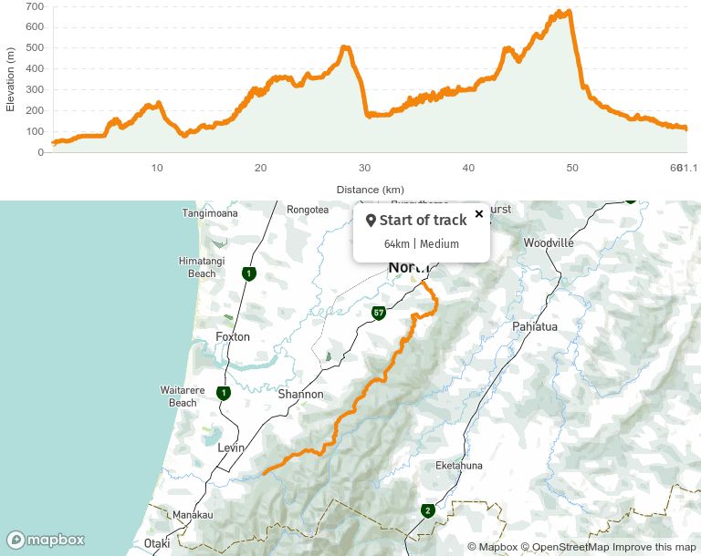
9/13/2021 Massey to Levin — NZ Walking Access Commission Ara Hīkoi Aotearoa Track maintained by Te Araroa Trail Trust Old West Road to Greens Road - 10km / 2-3hr From the carpark on Old West Road follow the Upper Turitea Walkway for a short distance then turn right into Turitea Road. Follow Turitea Road for about 1km. 300m after the one lane bridge, enter the gate on the left and follow the fenced off riparian reserve strip for 1km. The strip is a mix of developing and new riparian plantings by Green Corridors and Palmerston North City Council. Return to the road at a second one lane bridge, turn left and walk a further 500m along Turitea Road. Turn right into Ngahere Park Road. About 100m down the road cross the bridge over Turitea Stream, turn left through the gate and after about 10m on the right a new track leads up the hill for about 100m. At the top there are views over the valley and Tararua's. Take the staircase down and follow a the track through the bush. Turn right to join the Turitea Green Corridor Track. Cross a bridge then turn right and follow the track for about a kilometre though bush where the trail joins again on to Turitea Road. Turn right and follow the road for about 200m and cross the bridge. The trail passes the entrance on the left to the Turitea Dams (Palmerston North water reservoir, closed to the public). Take the gravel road/track to the right that rises gradually through native bush to the closed road which comes out at the end of Greens Road. Watch out for mountain bikes on this track. Greens Road to Back Track - 7km / 1.5-2hr Following Greens Road through open farmland, the track drops to the Kakuterawa Road junction, then heads up the Kahuterawa Road past the “Lions Reserve” picnic area following the Kahuterawa Stream. Near the end is the car park which serves as the hub for the Kahuterawa Recreation Area. From here it is a short walk to Black Bridge, where the Sledge Track and Back Track both start. Back Track to Burttons Track - 7km / 2-3hr https://www.walkingaccess.govt.nz/track/massey-to-levin/pdfPreview 2/8
9/13/2021                                Massey to Levin — NZ Walking Access Commission Ara Hīkoi Aotearoa

   Cross Black Bridge and follow Back Track, a former road which was closed in the 1960s. It is a
   steady climb up, mainly through native bush but with some open farmland allowing good views
   over the Manawatū and some pine forest near the top. Small streams are crossed and altitude
   rise is 200m before reaching the end of Scotts Road. A toilet was installed in October 2018 at the
   Arapuke Scotts Road Carpark. The nal 2km along Scotts Road leads to the entry to Gordon Kear
   Forest. From Scotts Road, a stile crosses the fence and an information sign is located just before
   the bridge over the Kahuterawa Stream.

   The walk to the start of the Burttons Track commences following the gravel forestry road
   alongside the Kahuterawa Stream. Keep right at the rst fork in the road and after
   approximately 40min from the start take the clearly signposted "Toko Corner Rd" to the right.

   The Palmerston North City Council (PNCC) has established an approved campsite for Te Araroa
   hikers in Gordon Kear Forest at a 28km walk from Palmerston North and 32km before Makahika
   Outdoor Centre.) It is in a clearing at the junction of Toko Corner Road and Centre Road. PNCC
   have built a shelter, (whare) called Motorimu. There is a picnic table, rubbish bin and superloo.
   There is a permanent freshwater stream at the site. For forestry safety reasons this is the only
   PNCC approved site for Te Araroa hikers to camp in Gordon Kear Forest.

   After a 5 minute walk along Toko Corner Rd the trail enters a recently cleared pine forest.
   Continue through the forest to a stile next to a locked gate, approximately 1hr walk from the
   locked gate just past the Loop Road sign post. Carry on, passing a second gate as you leave the
   plantation forest behind and enter regrowth native bush. The track climbs uphill to a stile and a
   DOC sign at the start of Burttons Track.

   Burttons Track - 15.5km / 6hr (7hr northbound)
   Descends through native forest to Tokomaru Valley. The track crosses the No 1 stream, sidles
   downstream a short distance and then begins to follow up the Tokomaru River. Remains of an
   old campsite with rusting iron are passed. After descending to the river and crossing No 2 creek,
   the track continues to follow the Tokomaru River upstream. Shortly after that the track crosses
   the Tokomaru River, clearly marked with large orange triangles.

   The track continues on the true left of the Tokomaru River for 15-20 minutes. The trail here is on
   private land.

        Note: Firearms are not permitted and dogs must remain on a leash.

https://www.walkingaccess.govt.nz/track/massey-to-levin/pdfPreview                                           3/8
9/13/2021 Massey to Levin — NZ Walking Access Commission Ara Hīkoi Aotearoa
Once you recross the river you soon re-enter the forest park and the start of the original
Burtton’s Track. Five minutes further on the former Burtton’s Whare site is reached. Considered
as midway, it is an ideal site for a lunch break and to absorb something of the history, well
described in Ian Argyles book Burtton’s Track.The site of the former swingbridge that crossed to
his farm on the western side of the river, that collapsed leading to the death of Jim Burtton in
1941 can be seen.
You may see a cottage on the other side of the stream however this is a PRIVATE residence,
please stick to the marked route (do not cross the river) and continue south. The trail here goes
over private land and we do not want to upset the owner who has given us permission to go over
their property.
From here the track is the historical trail built by Jim Burtton almost 100 years ago. Mostly
benched and of good width through regrowth bush, it follows up the Tokomaru River passing
some attractive open clearings. Remains of old bridges and other structures can be seen along
the way.
Note: For those interested in the history of Burtton's Track there is a booklet called
"Burtton's Track" by Ian Argyle, the cost is $8.00 including postage and is available from:
Te Araroa Manawatū Trust
P O Box 1922
Palmerston North
After another 1.5 hours, a stile is crossed as the track passes out of Tararua Forest Park.
The nal hour of walk is 3.2km is along the former Tokomaru Valley Road (now closed to
unauthorized traf c but is sometimes used by registered 4WD vehicles) to the junction with
Mangahao Road.
SHELTER
About 1km back on Tokomaru Valley Road from the junction of Mangahao Road a new shelter
called 'Tokomaru Shelter" is now open to Te Araroa walkers. There is a table and ve chairs and
a visitors book. There is also an outside toilet near the site.
Mangahao-Makahika Track - 20.5km / 1 day
https://www.walkingaccess.govt.nz/track/massey-to-levin/pdfPreview 4/89/13/2021 Massey to Levin — NZ Walking Access Commission Ara Hīkoi Aotearoa
From the junction of Tokomaru Valley and Mangahao Roads, walk southwest for 2.5km along
Mangahao Road, past the Tokomaru No 3 Reservoir (lake) to a small carpark and a short post
marking the of cial start of the Mangahao-Makahika Track.
(Note: It is 800m beyond the southern end of the reservoir and 400m past the Tararua Forest
Park sign).
From the carpark, the track enters the bush and climbs 15m to a low spur and a track
information sign, with distances and a map.
The track continues in a southerly direction for 2.5km passing some ne examples of large rimu
trees that escaped the bushman’s axe, before descending and crossing three tributaries of
Blackwood Stream (named after the magni cent Black Beech in the vicinity).
Note: Blackwood Stream is the last drinking water deposit until the Makahika Stream.
The track continues south with an easy and a gradual gain in elevation before veering to the
west (passing an area of re-generating Mānuka on land that was once farmed), before turning
south and following the Makahika Ridge.
Passing spot 657 (the highest point on the track), there are several openings to the west that give
an outlook down to the Mangaore Stream along with views of Kapiti and on a good day the South
Island is visible.
The Horowhenua Lookout, a small cleared area with seating, is reached after three to four hours
walking from the road end and gives a grand vista of Shannon, Horowhenua and the Manawatū.
The track soon drops off with a steady descent of 350m passing Kapiti Viewpoint (Archey’s
Lookout) where Kapiti Island, the South Island, the Makahika Valley and Gladstone Road are
seen again before reaching the terminus of the Makahika tramline formation. It was near this
point that the Bartholomew Timber Company ended native logging in this area of the Tararuas in
early part of the 20 century.
From here, the trail follows the former tramline route with benched track and cuttings clearly
visible in many places. Several crossings of the Makahika stream are encountered and about 30
minutes after meeting the tramline, open clearings appear amidst the native bush. These
clearings become more frequent until reaching a clearing with a plaque commemorating the
opening of this section of the track unveiled by the Prime Minister, the Right Hon. Helen Clark on
23rd February 2008. There is a toilet at this clearing, camping is allowed here.
https://www.walkingaccess.govt.nz/track/massey-to-levin/pdfPreview 5/89/13/2021 Massey to Levin — NZ Walking Access Commission Ara Hīkoi Aotearoa
Shortly after this the park boundary is reached with another orientation sign. Across the river is
the former sawmill site. For the last half hour, the track follows a poled route along an unfenced
right-of-way through private land and crossing the Makahika Stream before reaching the stile at
the Poulton Drive parking area.
Continue right along Gladstone Road for about 5km's passing Makahika Outdoor Pursuit Centre
on right and later turn left when you reach Poads Road.
Optional - (head into Levin for amenities/resupply) - The Arapaepae Lookout Track
This section of Te Araroa crossed east west over the Arapaepae and connects the Mangahao-
Makakia Track leading north toward Sahnnon with Levin
Getting there
Coming from Makahika track exit, the trail starts at a locked gate 1.3km down Gladstone road
and 300m before the Makahika Outdoor Pursuit centre
from Levin, follow Queen Street East toward the hill and turn left into Denton Road. It is 100m to
the car park and a further 50m to the start of the track
Track Description
The track is 7.3km with an elevation gain of 250m and can be walked from either direction. Easy
walking time considered as 2hrs 30min either way or 5hr return. Being close to Levin, the area is
frequently used by local walkers, joggers and mountain bikers.
From Denton road parking area, a sign located inside the locked gate shows the trail route
through the Matariki Forest and estimated times:
Arapaepae Lookout - 3.5km - 1 1/4hr
Spencer Junction - 4.7km - 1 3/4hr
Gladstone Road - 7.3km 2 1/2 hr
The trail ascends on a steady gradient through the pine forest until it reaches a junction on the
ridgeline (2.3km) where it turns left and follows the ridge north. Adjacent to the forestry road are
mountain bike trails with numerous jumps. For safety reasons, walkers are asked to stay off these
trails.
https://www.walkingaccess.govt.nz/track/massey-to-levin/pdfPreview 6/89/13/2021 Massey to Levin — NZ Walking Access Commission Ara Hīkoi Aotearoa
Walking North through the cleared areas, there are views east to the Tararua Ranges and west
over Levin and the Horowhenua with the best view of all being from a large cleared area "the
Arapaepae Lookout" which is 80m from the Ridge Road junction. From here Kapiti Island is
easily visable and on clear days the South Island, Mt Taranaki and Mt Ruapehu can also be seen.
Following Ridge Road for a further 1.2km to Spencer Junction, there are good views into the Ōhua
and Makahika Valleys. The trail then descends and passes through an area of native bush,
designated the Bentons Bush Covenant and managed by the Department of Conservation.
Nearing the bottom the trail passes an old rock quarry site and crosses the bridge Makahika
Stream before reaching the locked gate onto Gladstone road.
Walkers starting from the Gladstone Road end should allow an extra half hour for the climb to
Spencer Junction and a similar time saving on descent from Arapaepae Lookout to Denton
Road.
Conditions:
Potential hazards:
Vehicles on road or track Stay alert for logging traf c in Gordon Kear Forest
Poisons & traps
Forestry operations
River crossings - Never cross ooded rivers
Small stream crossings
Track exposed to sun, wind or cold
Weather extremes
Burrtons Track:
Please note: This trail crosses private land - Open daylight hours ONLY.
NO Horses, guns, vehicles, res in forest.
Dogs MUST be ON lease.
How to get here
Northern Start: Old West Road (SH57), Palmerston North
Southern End: Junction of Gladstone and Poads Roads, Levin
https://www.walkingaccess.govt.nz/track/massey-to-levin/pdfPreview 7/89/13/2021 Massey to Levin — NZ Walking Access Commission Ara Hīkoi Aotearoa Track Elevation and Map More information Te Araroa Manawatū-Whanganui trail notes, including information about accommodation transport and resupplying Page last updated: Jan 5, 2021, 2:26 PM https://www.walkingaccess.govt.nz/track/massey-to-levin/pdfPreview 8/8
You can also read