Meteorology: Clouds in the Sky
←
→
Page content transcription
If your browser does not render page correctly, please read the page content below
Meteorology:
Clouds in the Sky
MAIN IDEA
Head outside and observe the sky to identify different types of clouds. Then create your own 3D model
of your favorite cloud with common materials. This is a great activity for children five and under also!
SCIENCE BACKGROUND
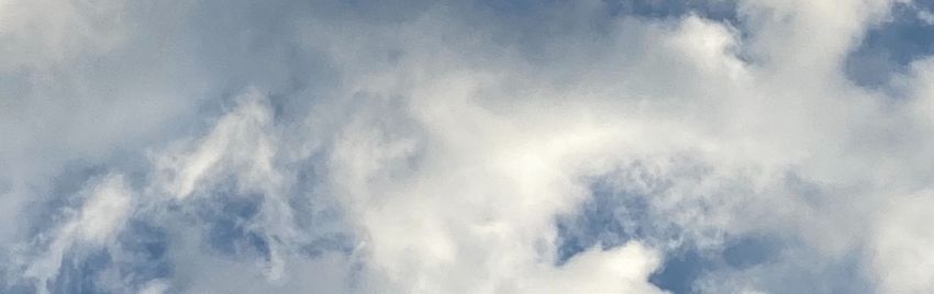
Clouds are made up of tiny water droplets and/or ice crystals that are so small, they can float in the
air. Clouds form when warmer air made up of water vapor, the gaseous form of water, rises from the
surface due to evaporation, the transformation of a liquid into a gas, or oceans, lakes and rivers. As the
air rises it cools and then condenses, when a gas transforms into a liquid, to form little water droplets.
Usually this occurs when small particles, such as dust or pollen, are in the air as well providing the
surrounding water vapor a surface to condense on when it cools. These particles are known as cloud
condensation nuclei.
There are several types of clouds that are named primarily based on their shape and height in the sky.
Flatter clouds have names that include “strato” and vertical clouds have names that include “cumulo.”
Clouds that produce rain include “nimbo” in their name.
High level clouds (above 20,000 ft) are composed of ice crystals and have names that begin with
“cirro,” including cirrus, cirrocumulus, and cirrostratus. Mid-level clouds (6,500 to 20,000 ft) are
composed of both ice crystals and water droplets and have names that begin with “alto,” including
altostratus and altocumulus. Low level clouds (below 6,500 ft) are compose of water droplets and have
all kinds of names including status, nimbostratus, stratocumulus, and cumulus.
One common cloud type in Florida are cumulonimbus clouds. These are tall rain clouds that can reach
heights of up to 60,000 ft, and due to the combination of ice crystals, water droplets, and extreme
vertical motion, can end up producing lightning if the conditions are right.
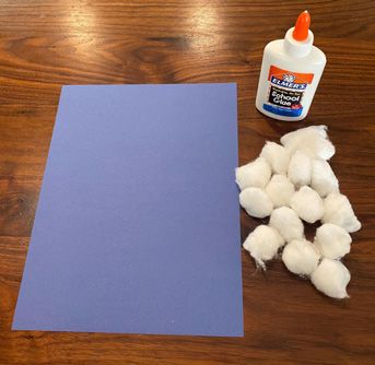
MATERIALS
Cloud guide from NASA/NOAA (see page 4)
Construction paper (color of your choice)
Cotton balls (or pompoms and other paper products)
Glue
Optional: Markers
Optional: Sheet or blanket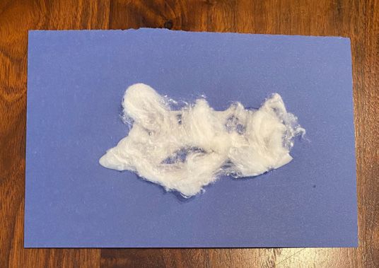
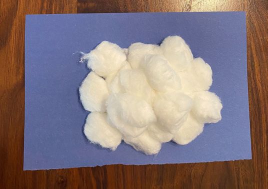
ACTIVITY PROCEDURE
STEP 1: Grab your cloud guide and head outside to look up at the sky.
STEP 2: Lay on the ground (feel free to use a sheet or blanket if you prefer), and look up at the sky. As
clouds pass by, try to identify what kind of cloud they are by using your cloud guide.
Pro tip: If it is raining, you can still identify the clouds using the cloud guide from inside your house!
STEP 3: After sky watching for as long as you’d like, come back inside to create your own 3D cloud model.
STEP 4: Using the cloud guide, and your own observations, pick what kind of cloud model you would
like to create.
   What kind of clouds did you identify?
   What kind of cloud did you choose?
STEP 5: Use the cotton balls to build your model. For flatter clouds (such as cirrus), you will need to
pull on the cotton ball to spread it out. For taller clouds (such as cumulus), you will need to glue several
cotton balls together to make it big and fluffy.
   How do you think you will need to change the cotton balls to build your cloud?
   Will you need many cotton balls or just one? What about for a different kind of cloud?
STEP 6: Glue the cloud to your construction paper sky to share.
Optional: Use the markers to decorate your sky before gluing the cloud to the paper sky.
Then, for extra fun, take your cloud model outside to compare with the clouds in the sky!
EDUCATIONAL STANDARDS
Kindergarten
Big Idea 1: The Practice of Science
SC.K.N.1.2 - Make observations of the natural world and know that they are descriptors collected using
the five senses.
SC.K.N.1.4 - Observe and create a visual representation of an object which includes its major features.
Grade 1
Big Idea 1: The Practice of Science
SC.1.N.1.2 – Using the five senses as tools, make careful observations, describe objects in terms of
number, shape, texture, size, weight, color and motion, and compare their observations with others.
Grade 2
Big Idea 7: Earth Systems and Patterns
SC.2.E.7.1 - Compare and describe changing patterns in nature that repeat themselves, such as
weather conditions including temperature and precipitation, day to day and season to season.
Grade 5
Big Idea 7: Earth Systems and Patterns
SC.5.E.7.3 - Recognize how air temperature, barometric pressure, humidity, wind speed and direction,
and precipitation determine the weather in a particular place and time.
Grade 6
Big Idea 7: Earth Systems and Patterns
SC.6.E.7.2 - Investigate and apply how the cycling of water between the atmosphere and hydrosphere
has an effect on weather patterns and climate.

ADDITIONAL RESOURCES
UCAR Center for Science Education – Clouds
https://scied.ucar.edu/clouds
UCAR Center for Science Education - Field Guide to Clouds Mobile App
https://scied.ucar.edu/apps/cloud-guide
NASA Space Place – Clouds
https://spaceplace.nasa.gov/search/clouds/
CLOUDSAT GOES-R
Wild World of Clouds
Studying Clouds from Space Up to 60,000 ft (18,000m)
Satellites in orbit above Earth provide images and other
information about the atmosphere and enable weather
forecasters and climatologists to do their jobs.
CloudSat, a NASA Earth-observing satellite, uses radar to see
inside the clouds from top to bottom. CloudSat measures their
thickness, their altitude at top and bottom, their reflective
properties, and their water and ice content. Data from CloudSat
is used to improve our ability to accurately forecast the weather
and improve long-term global climate predictions.
GOES-R is a new satellite, the first one planned for launch in Cirrus
2016. Geostationary Operational Environmental Satellites
(GOES) orbit 22,300 miles (35,888 kilometers) above Earth’s
Commercial Jetliner
equator. They orbit once per day as Earth rotates. Thus the (36,000 ft / 11,000m)
GOES look down upon the same part of Earth all the time. One
GOES primarily watches the east coast of the U.S. and one
GOES watches the west coast. They observe weather
developments, including ocean temperatures, and help
forecasters warn people of developing storms, such as
hurricanes. The new GOES-R will replace the current GOES. Breitling Orbiter 3
GOES-R will be able to do everything the GOES do, and more. (34,000 ft / 10,400m) Cirrocumulus
GOES-R will gather more detailed, accurate images and other
data faster than ever. It will be able to map where lightning strikes
are occurring, even in the daytime. Mount Everest
(29,035 ft / 8,850m)
Reading the Clouds
Clouds, which are collections of water droplets, are beautiful and Cirrostratus
fun to watch. If we learn to "read" them, we can know what is
happening at different levels of the atmosphere and what kind of 20,000 feet (6,000 m) Cumulonimbus
weather may be on the way. Clouds are classified by their shape
or appearance and their height above the ground.
High clouds start above around 20,000 feet (6,000 meters). They
often look thin and patchy or feathery. Their names start with
"cirro," which means "curl of hair" in Latin:
Cirrus clouds look like delicate strands or hooks.
They are made mostly of ice crystals.
Cirrocumulus are thin, patchy clouds that may
have rippled or wavelike patterns. Altocumulus
Cirrostratus are thin, sheet-like clouds that cover
most of the sky.
Mid-level clouds form from 6,500 feet (2,000 meters) to 20,000
feet (6,000 meters). They usually look rather flat and layered,
because the air at these altitudes doesn't move very much Altostratus
vertically. Their names always start with "alto":
Migrating Ducks and Geese
Altocumulus are white or gray puffy, patchy clouds
with spaces between them. They may appear to be
(8,000-9,000 ft / 2,500-2,800m)
lined up in rows.
6,600 feet (2,000 m)
Altostratus form a gray or bluish-gray uniform-
looking layer that covers much or most of the sky.
Low-level clouds are found below about 6,500 feet (2,000
meters). They are either flat and layered or rounded on top, with
flat bases: Stratocumulus
Stratocumulus have distinct gray or whitish
rounded patches. They may look rolling or puffy,
but are often merged together into layers with no
spaces between them.
Cumulus clouds are fluffy and cauliflower-like, with
rounded white tops and flat grayish bases.
Stratus form a flat, thin, uniform cloud layer. They
usually contain insufficient water to produce Cumulus
significant rain or snow. Stratus clouds that reach
down to the ground we call fog.
Nimbostratus are dark, gray clouds that are
dropping rain or snow. They usually cover the entire
sky. Sometimes nimbostratus are found higher in
the atmosphere, in the mid-altitudes.
Nimbostratus
Cumulonimbus clouds are the kings of all clouds, rising from low
altitudes to more than 60,000 feet (20,000 meters) above ground
level. They grow due to rising air currents called updrafts, with
their tops flattening out into an anvil shape. Cumulonimbus are a Rain / Snow
sure sign of severe weather, with heavy rain and possibly hail.
Stratus
Fog Fog
Sears Tower, Chicago
(1,450 ft / 500m) AN
DA
PH
TMOS ERIC AD
MI
NI
C
ST
NI
R
EA
ATI
NATIONAL OC
ON
U.S
EP
. D
AR CE
T MEN ER
T OF COMM
EW-2010-12-016-JPLYou can also read