Microwaves and Radar Institute - Overview of Projects and Research Activities - DLR
←
→
Page content transcription
If your browser does not render page correctly, please read the page content below
Institute’s Brochure

                       Microwaves and
                       Radar Institute

                       Overview of Projects
                       and Research Activities

                       1
German Aerospace Center
                            A member of the Helmholtz Association

                            Microwaves and Radar Institute

Director of the Institute   Prof. Dr.-Ing. habil. Alberto Moreira

                Address     Oberpfaffenhofen
                            D-82234 Weßling
                            www.dlr.de/HR

                 Layout     Renate Weist

              Printed by    Digital- & Offsetdruck Wolfertstetter KG, Gilching

                            June 2013

                  Cover     TanDEM-X Mission

                            This brochure may be reprinted in whole or in part or otherwise used
                            commercially only by previous agreement with the DLR.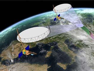
Examples of such research programs are
Institute’s Profile                          bistatic and multistatic SAR systems,
                                             digital beamforming, inverse SAR,
Mission                                      polarimetric SAR interferometry and
                                             tomography, calibration, signatures,
With its know-how and expertise in           propagation, antennas, as well as radio-
passive and active microwave remote          metry and imaging techniques for
sensing, the Microwaves and Radar            security.
Institute contributes to the development
and advancement of ground-based,             Organization                                        Microwaves and Radar Institute
airborne and spaceborne sensors.                                                                 Microwaves and Radar Institute.
The focus of its research work is on the     The Institute has 4 departments working
conception and development of new            in well established research programs,
synthetic aperture radar (SAR) techniques    projects and external contracts.
and systems, as well as sensor-specific      The Institute has about 145 employees,
applications. The Institute‘s strength is    comprising scientists, engineers,
the execution of long-term research          technicians, support personnel, as well as
programs with applications in remote         internship, diploma and doctoral
sensing, aeronautics and traffic monitor-    students, and guest scientists.
ng, as well as reconnaissance and
security. In line with the German space      Three Institute’s departments are
program, the Institute works in close        working on Earth observation and one
collaboration with other DLR institutes,     on reconnaissance and security. The SAR
the German Space Administration, the         Technology department is responsible
European Space Agency, German                for the development of the airborne SAR
industry and responsible ministries.         system F-SAR and contributes to the
                                                                                                 TechLab: a new building for high-tech
The education of young scientists in         spaceborne SAR projects with airborne
                                                                                                 microwave sensor development.
the form of hosting and supervising          campaigns to simulate new data
internships, as well as diploma and          products, to validate and cross-calibrate
doctoral theses is also an important         the satellite data and to demonstrate
part of the Institute’s mission.             new techniques.

Research and Projects                        The Satellite SAR Systems department
                                             and the Radar Concepts department are
In the last 5 years, the Institute has       engaged in new spaceborne SAR
actively participated and also initiated     missions, and are developing new sensor
several SAR missions and research            concepts and techniques for future radar
programs that are decisive for its long-     systems. The Satellite SAR Systems
term strategy. Important examples are        department is responsible for operating
TerraSAR-X, TanDEM-X, F-SAR (new             the radar instruments on TerraSAR-X and
airborne SAR) and SAR-Lupe. It is also       TanDEM-X and holds the position of the
working on future remote sensing and         mission manager. The Radar Concepts
reconnaissance systems, such as              department also contributes with the
Sentinel-1 (ESA GMES program),               development of new sensor-related                   Compact Test Range Facility.
TerraSAR-X2 (follow-on to TerraSAR-X),       applications. For military spaceborne SAR
HRWS (next generation X-band SAR with        activities, all major projects and activities
high-resolution wide-swath imaging),         are concentrated in the Reconnaissance
Tandem-L (L-band mission proposal)           and Security department. The Institute’s
BIOMASS (ESA Earth Explorer mission),        expertise in passive microwave systems
VABENE (DLR project for traffic              is also in this department, as most of the
monitoring with radar) and the SAR-Lupe      passive microwave projects are presently
follow-on program. These projects are        related to security applications.
accompanied by research programs that
ensure the Institute keeps a step ahead in
the development of new research fields.

                                                                                             1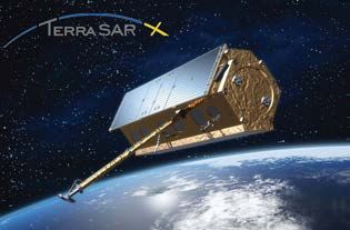
development, as well as SAR system
                                                 Expertise and                                   specification.

                                                 Facilities                                      In 2009, all Institute’s facilities and
                                                                                                 technological developments have been
                                                 With the continuity of successful research      concentrated in a new building –
                                                 in SAR over 35 years it has been possible       TechLab – a center for high-tech
                                                 to channel the experience gained from           microwave sensor development with
                                                 the planning and implementation of              several laboratories and measurement
                                                 international space missions into a             facilities, and approx. 25 employees.
F-SAR: The new airborne SAR system of DLR.
                                                 national SAR program. Due to the end-           The main facility is a compact test
                                                 to-end system know-how from data                range for highly accurate antenna
                                                 acquisition (including the Institute’s          characterization, as well as for radar
                                                 airborne SAR), system design to data            cross-section measurements. Further
                                                 interpretation and research into new            facilities are a microwave chamber for
                                                 applications, the Institute has become          measuring monostatic and bistatic radar
                                                 one of the leading international research       signatures of scaled target models,
                                                 institutions in SAR. The Institute is today     facilities for determining the dielectric
                                                 recognized as a leading research center         properties of material samples and a pool
                                                 on synthetic aperture radar.                    of ground equipment for spaceborne
                                                                                                 SAR calibration. Also included in TechLab
                                                 The Institute has a number of large-scale       are several research laboratories,
                                                 facilities to support its research activities   especially equipped for the development,
                                                 in microwave sensor development and             optimization, integration, testing and
                                                 associated technologies. The airborne           calibration of radar and radiometer
                                                 SAR system F-SAR is the successor of            systems.
                                                 the well-known E-SAR system of DLR.
                                                 F-SAR is a totally new development              The Institute operates also a microwave
                                                 utilizing the most modern hardware and          mechanical laboratory for the design,
                                                 commercial off-the-shelf components.            development and manufacture of
                                                 As for E-SAR, DLR’s Dornier DO228-212           microwave components, instruments
                                                 aircraft was the first choice as the plat-      and models, using numerically controlled
                                                 form for the new system. F-SAR is a             machines. The laboratory also manu-
                                                 modular system operating in X, C, S, L          factures miniaturized and hollow
                                                 and P-band. Besides the fully polarimetric      components using galvanic and galvano-
                                                 capability in all frequencies, it allows the    plastic techniques. It provides valuable
                                                 operation of up to 4 frequencies at the         consultancy for the researchers and
                                                 same time with a data rate up to 1 Gbit/s       developers in the specification and design
                                                 per channel. The geometric resolution           of microwave instruments and
                                                 varies from 2.5 meters to 25 centimeters        experimental set-ups.
                                                 depending on the frequency band and
                                                 user requirements. F-SAR is fully recon-
                                                 figurable and will include innovative
                                                 operation modes with digital beam-
                                                 forming on receive in future system
                                                 upgrades. The main objectives of the
                                                 airborne flight campaigns are the
                                                 development of innovative SAR modes
                                                 or operational configurations, the
                                                 demonstration of novel techniques
                                                 and applications, as well as performing
                                                 preparatory experiments for future SAR
                                                 satellite systems, supporting data product

                                             2
(SRTM/X-SAR) in 2000. A next important
Synthetic Aperture                            step in Germany’s radar roadmap was
                                              taken in 2001 with the decision to build
Radar                                         the first dedicated radar satellite.
                                              TerraSAR-X was launched in 2007
Synthetic Aperture Radar (SAR) is an          and is providing high-quality images
indispensable source of information in        with a resolution up to 1 m.
Earth observation, since SAR is the only      TanDEM-X, a rebuild of TerraSAR-X with
spaceborne sensor that has high-              some modifications for allowing bistatic
resolution, all-weather and day-and-night     interferometry in close formation flight,
imaging capability. SAR plays a major role    was launched in 2010 and is acquiring
in a wide spectrum of applications, such      a digital elevation model of the entire         TerraSAR-X satellite was launched
as environmental monitoring, retrieval of     land surface of the Earth with a height         in June 2007 and is providing since then
bio/geo-physical parameters of land,          accuracy better than 2 m. The roadmap           high-quality images with a resolution
vegetation, water, snow and ice surfaces,     for the German radar program foresees           up to 1 meter.
hazard and disaster monitoring as well        the launch of a next generation X-band
as reconnaissance and security related        SAR satellite by the end of this decade.
applications. Further measurement             The SAR instrument will have a digital
capabilities are achieved by repeat-pass      beamforming capability on receive, in
interferometry (e.g. deformation of the       order to allow simultaneously high-
Earth surface to millimeter accuracy),        resolution and wide-swath imaging.
single-pass across-track interferometry
(e.g. generation of digital elevation
models), e.g. polarimetry (e.g. soil          Projects
moisture estimation), polarimetric SAR
interferometry (derivation of forest height   TerraSAR-X
and above-ground biomass), as well as
                                              On June 15, 2007, Germany's first
SAR tomography (e.g. forest structure
                                              operational radar satellite TerraSAR-X
profiling).
                                              was launched into orbit. The mission is
Today, we have entered into a new era         implemented in a public-private partner-
of spaceborne SAR systems. Satellite          ship (PPP) between DLR and EADS
systems like TerraSAR-X, TanDEM-X,            Astrium GmbH. The TerraSAR-X satellite          Multi-temporal TerraSAR-X image
Radarsat-2 and COSMO-SkyMed are               has been developed by EADS Astrium              of the Sylt island in North Germany
providing radar images with a resolution      GmbH; four DLR institutes in                    (green: 22 Oct., blue: 24 Oct., and
more than one order of magnitude better       Oberpfaffenhofen have developed                 red: 27 Oct., 2007).
than that of previous SAR systems. They       the ground segment and are operating
are also outperforming by far previous        the mission.
systems with respect to their imaging
                                              TerraSAR-X supplies high-quality radar
flexibility and interferometric modes.
                                              data for a mission life-time of at least five
German Space Radar Program                    years (current expectation is more than
                                              six years). In this context, TerraSAR-X
Germany has focused its national space        serves two main goals: 1) To provide the
radar program on the development of           scientific community with multi-mode
X-band SAR instruments. MRSE –                X-band SAR data, and 2) to establish a
Microwave Remote Sensing Experiment –         commercial Earth observation market,
was the first spaceborne X-band SAR           i.e. to develop a sustainable EO business,
instrument and was carried on-board the       so that follow-on radar satellite systems
Space Shuttle mission Spacelab-1 in           can be completely financed by industry
1983. In cooperation with NASA/JPL and        from the revenues. TerraSAR-X is an
ASI, the next X-band SAR instrument           advanced X-band radar satellite with a
flew on-board two Shuttle radar imaging       phased array antenna consisting of
missions (SIR-C/X-SAR) in 1994, followed      384 transmit and receive modules.
by the Shuttle Radar Topography Mission       The antenna is fixed mounted to the

                                                                                              3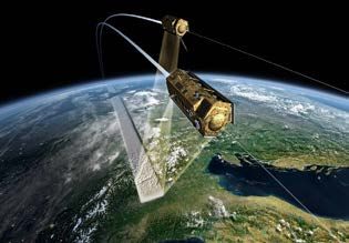
of the Mission Manager who chairs the
Mission Board, also including the science
and the commercial coordinators.
The Mission Board decides on the
strategic planning and all issues related
to daily business, nominal operations and
contingencies. Representing the German
federal government, the DLR is the sole
owner of the TerraSAR-X data and
coordinates the scientific data utilization.
TanDEM-X
TanDEM-X (TerraSAR-X add-on for
Digital Elevation Measurement), initiated
jointly by the Microwaves and Radar
Institute and EADS Astrium GmbH in
2003, opens a new era in spaceborne
radar remote sensing. A single-pass SAR
interferometer with adjustable baselines
in across and along-track directions
Digital elevaton model generated by TanDEM-X showing the largest salt flat in the world is formed by adding a second, almost
(Salar de Uyuni, Bolivia). Since the start of the operational phase in December 2010, TanDEM-X identical spacecraft to accompany
is mapping ca. 12 million square kilometers per month in interferometric mode. TerraSAR-X in a closely controlled
formation. With typical across-track
baselines of 200 – 400 m, a global digital
spacecraft body and spans an overall
elevation model (DEM) with 2 m relative
aperture size of 4.8 x 0.7 m. The center
height accuracy at 12 m horizontal
frequency of the radar instrument is
posting is being generated. DEMs are
9.65 GHz with a selectable system
of fundamental importance for a broad
bandwidth of up to 300 MHz. Variable
range of scientific and environmental
antenna beams and multiple operation
applications. For example, many geo-
modes can be selected like stripmap
science areas, like hydrology, glaciology,
(3 m resolution, 30 km swath width),
forestry, geology, oceanography, and
scanSAR (16 m, 100 km swath width),
environmental monitoring require precise
or high-resolution spotlight mode (1 m,
and up-to-date information about the
5/10 x 10 km image size). The imaging
Earth’s surface and its topography.
modes can be further combined with
Beyond the primary mission objective,
different polarization settings. In the
TanDEM-X provides a configurable SAR
scope of the calibration activities for
interferometry test bed for demonstrat-
TerraSAR-X, it has been demonstrated
ing new SAR techniques (multistatic SAR,
that the calibration accuracy of the radar
polarimetric SAR interferometry, digital
images is better than 0.3 dB and that the
beamforming and super resolution)
geo-localization accuracy is in the order
and associated applications.
of 30 centimeters.
An orbit configuration based on a helix
The Institute has contributed to the geometry has been patented by the
TerraSAR-X project with a dedicated Institute and was selected for safe
SAR system engineering activity with the formation flying of the two satellites.
TanDEM-X (TerraSAR-X add-on for design, implementation and operation In order to allow accurate phase
Digital Elevation Measurement), initiated of the Instrument Operations and information in the bistatic acquisition
jointly by the Microwaves and Radar Calibration System (IOCS) and with the mode, the radar instruments feature
Institute and EADS Astrium GmbH, opens development and execution of the end- a new technique for exchanging phase
a new era in spaceborne radar remote to-end system calibration. Beyond these information via dedicated microwave
sensing. tasks, the Institute also holds the position links.
4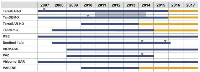
Combined data acquisition planning for        a unique data source to observe, analyze
both the TerraSAR-X mission with single       and quantify a wide range of mutually
localized requests as well as for the         interacting processes in the biosphere,
TanDEM-X mission with a global DEM            lithosphere, hydrosphere and cryosphere.
mapping strategy is a major challenge         The systematic observation of these
under the constraints of limited space        processes benefits from the high data
segment resources. For generating the         acquisition capacity and the novel high-
global DEM roughly 350 TByte of raw           resolution wide-swath SAR imaging
data will be acquired using a network         modes that combine digital beamforming
of ground receiving stations. Processing      with a large reflector antenna.
to DEM products requires advanced
multi-baseline techniques and involves        One key technology of Tandem-L is the
mosaicking and a sophisticated                use of a large reflector antenna in             Tandem-L: Proposal for a highly
calibration scheme on a continental scale.    combination with digital beamforming            innovative L-band mission.
The global DEM will be available by end       in the feed array that illuminates the
2014. Besides the tasks in the develop-       reflector. While all feed elements are
ment of the ground segment, the               used during transmission, allowing the
Institute is managing the ground              illumination of a large image swath,
segment project in Oberpfaffenhofen           2-3 feed elements are activated during
and coordinates the scientific activities     the receive window. The feed element
of the TanDEM-X mission.                      positions are periodically shifted
                                              following the systematic variation of the
TanDEM-X represents an important step         direction of arrival of the swath echoes.
towards a constellation of bistatic and
multistatic radar satellites and will         The advantages of this concept are
provide sustained support for Germany’s       manifold. First, the use of a large
leading role in spaceborne SAR tech-          reflector antenna in connection with
nologies and missions.                        digital beamforming allows the reduction
                                              of the transmit power by a factor of 3-4
Tandem-L                                      compared to the traditional SAR concept
Tandem-L is a mission proposal initiated      for the same imaging parameters.
by the Institute for an innovative inter-     Second, it allows the mapping of a              Tandem-L: Simulation of the forest height
ferometric L-band radar instrument that       much wider swath (approx. 350 km)               derived from two radar acquisitions using
enables the systematic monitoring of          in high-resolution stripmap mode.               polarimetric SAR interferometry.
dynamic Earth processes using advanced        The fully polarimetric acquisition in           The forest biomass can be estimated
techniques and technologies. The mission      stripmap mode with a wide swath is              from the forest height using an allometric
is science driven, aiming to provide a        possible without the constraints of             equation and the forest profile.
unique data set for climate and environ-      conventional SAR systems.                       This image shows the area of Traunstein,
mental research, geodynamics, hydrology                                                       Germany.
and oceanography. Important application       It is planned to realize the Tandem-L
examples are global forest height and         mission in cooperation with an
biomass inventories, measurements of          international partner. The mission
Earth deformation due to tectonic             concept was developed in detail in a two-
processes and/or anthropogenic factors,       year pre-phase A study and it will be
observations of ice/glacier velocity fields   further investigated in the next 18
and 3-D structure changes, and the            months. The cooperation with an
monitoring of soil moisture and ocean         international partner will allow
surface currents.                             a cost-effective implementation,
                                              whereby each partner contributes with
The Tandem-L mission concept consists         its predevelopments and experience.
of two cooperating satellites flying in       According to current planning, the
close formation. The Pol-InSAR and            Tandem-L satellites could be launched
repeat-pass acquisition modes provide         in 2019.

                                                                                          5
Future Research Tandem-L is a radar mission proposal in
L-band. A pre-phase A study has been
Activities & Projects performed from 2008 to 2011. The study
has been extended until 2014 in order
Looking ahead to the next 5 years, the to investigate a joint relization of
Institute will continue to initiate and Tandem-L with JAXA. The decision for
contribute to several projects that will implementation depends on an approval
be decisive for its long-term strategy. of the required funding which is
The table below shows the most expected to occur by the end of 2014.
important projects in the Institute.
The number of projects since 2006 The project RSE is fully funded by the
has increased considerably. By means German MoD and encompasses all
of the Institute’s contributions to the activities of the Institute related to
TerraSAR-X, TanDEM-X and SAR-Lupe security and reconnaissance. It includes
projects, a highly qualified project team the technical support, engineering and
has been established. Due to the high mission analysis of SAR-Lupe and its
degree of innovation in science and follow-on system, as well as the passive
technology, the mission Tandem-L microwave sensor developments.
represents the most important project
for the Institute in the years to come and Since 2009 the Institute has contributed
can be seen as a next milestone in the to the TerraSAR-X2 phase A study.
national radar roadmap after TanDEM-X. It is expected that TerraSAR-X2 will
include new technological parts of
National Missions and Projects
a high-resolution wide-swath (HRWS)
TerraSAR-X and TanDEM-X are national SAR system. Different to TanDEM-X,
high-resolution radar satellites launched the requirements for TerraSAR-X2 are
in 2007 and 2010. The tandem operation mainly driven by commercial applications.
of both satellites for DEM generation is However, according to the PPP agree-
planned until mid 2014, but an extension ment, TerraSAR-X2 will ensure X-band
of the operation is expected, because data continuity for the scientific
TerraSAR-X is still fully functional and has community.
sufficient resources available. Although
the nominal lifetime of TerraSAR-X is European Projects
specified to be 5.5 years, an extension
to more than 7 years is expected. Sentinel-1a and Sentinel-1b are two
C-band radar satellites from the EU/ESA
GMES program with a launch scheduled
Most important projects in the Institute. Bars in orange show the planned continuation of for beginning 2014 and 2015, resp.
the respective project. Satellite launches are indicated by triangles. The Institute’s contribution lies in the
definition of the end-to-end system
calibration concept and algorithms.
It is expected that the Institute will
participate in the calibration during the
commissioning phase of the satellites
and also contribute to the envisaged
calibration and image quality control
center of ESA.
6BIOMASS (P-band SAR, fully polarimetric) Resource allocation in the Institute for the projects and research programs. More than 70%
is an Earth Explorer mission recommen- of the Institute’s resources are allocated to DLR projects and external contracts.
ded for implementation. The Institute is
involved in the calibration and several
science studies for the two radar
missions. For BIOMASS, the Institute is
the prime contractor for the development
of the complete end-to-end mission
performance simulator. Further activities
include flight campaigns with the
airborne SAR.
The Institute also contributes to the
Spanish PAZ satellite with the delivery
of the SAR related software modules for
instrument operations and calibration.
The PAZ satellite is a TerraSAR-X based
satellite, the launch is scheduled for
beginning 2014.
DLR Internal Projects Research Programs
F-SAR is the new airborne SAR system The above mentioned projects are
of DLR that became fully operational by accompanied by several research pro-
2012. It is planned to expand the grams. The table on the top summarizes
F-SAR system to include a digital beam- the internal and external projects as well
forming capability by 2015. Several as the research programs that are funded
internal and external flight campaigns by the DLR program directorates in the
have already been executed with F-SAR areas of space, aeronautics and trans-
since 2008, the intensive operational portation. Examples of research programs
phase started in 2012. are new SAR concepts, signal processing,
airborne SAR, information retrieval,
F-SAR has been extended to a 4-channel calibration, and signatures. The research
system for road traffic monitoring (DLR programs are closely interconnected with
internal project VABENE). The Institute the project activities. As a matter of fact,
has submitted a proposal for developing most of the current projects of the
a low-cost, compact airborne SAR for Institute have started as research pro-
road traffic monitoring based on the grams with typical durations of 2 to
F-SAR technology. This project has 5 years. Due to the long-term aspect of
started mid 2012. the Institute’s projects, it has developed
a roadmap for the future radar activities
The DLR projects FaUSST and FFT-2 jointly with its partners in industry and
deal with UCAVs (Unmanned Combat research. This roadmap is being updated
Aerial Vehicles) and agile missiles, on a regular basis. As of today, the
respectively. Several disciplines, like Institute has more than 70% of its
aerodynamics, flight control, material resources allocated to DLR projects
sciences, actuation, radar and infrared and external contracts. Considering
signatures are represented. The Institute's the success in the approval of the new
contributions are investigations mid-term and long-term projects, it is
concerning radar signatures, radar expected that this percentage will
detection probabilities and radome be maintained above 70% in the
microwave transmission. next 5 years.
7High-flying and unmanned vehicles
Low Earth Orbit Satellites
(LEO)
Vision will certainly act as a complementary
platform for this network of sensors.
In a changing and dynamic world, Furthermore, radar satellites flying
timely and high-resolution geospatial in close formation will allow the
information with global access and construction of sparse arrays with
coverage becomes increasingly im- enhanced imaging capabilities.
portant. Constellations of SAR satellites
will play a major role in this task, since Another important aspect for present
SAR is the only spaceborne sensor that and future microwave sensors is the
has all-weather, day-and-night, high- ability to provide quantitative and reliable
resolution imaging capability. Examples data products to the user community.
of applications for such a constellation Today, the sensor information becomes
Geostationary Illuminator are environmental remote sensing, road multi-dimensional, as different sensor
+ Low EO Receivers traffic, hazard and disaster monitoring, sources, polarizations, temporal and
as well as reconnaissance and security spatial baselines, aspect angles and
related applications. frequencies are used for parameter
retrieval. The Institute will direct its
One challenge for future spaceborne efforts towards more accurate system
SAR systems is to optimize the calibration to improve product quality
performance/cost ratio as much as and reliability, as well as towards the
possible, so that a constellation of development of algorithms for sensor-
satellites becomes affordable. Innovative specific parameter retrieval, as in the case
concepts with bistatic and multistatic of multi-baseline polarimetric SAR
system configurations represent an interferometry and tomography.
Medium EO Satellites attractive solution, exploiting the use
(MEO) of small receiver satellites which acquire In some respect, the vision of a SAR
the backscattered signal of active MEO sensor network is not too far away.
or GEO satellites. Utilization of the same The successful TanDEM-X mission
transmit signal for different applications is an important milestone and the
can also be explored, as in the case of implementation of Tandem-L would be
GPS reflectometry for ocean and land a further major step towards this vision.
remote sensing. Digital beamforming on The Institute is committed to increase
transmit and/or receive will solve the its role in the development of future
contradiction posed by the antenna size microwave satellites for remote sensing,
in traditional SAR systems that prohibits reconnaissance and traffic monitoring.
the SAR sensor from having high azimuth It aims to expand its expertise and
Concepts for a future constellation of resolution and a large swath width at leadership in strategically important
radar satellites for quasi-continuous the same time. Digital beamforming is projects and research areas. Together
monitoring of the Earth. a clear trend for future systems, allowing with its cooperation partners in DLR,
Top: low Earth orbit (LEO) satellites, enormous flexibility in the sensor imaging industry and science, the Institute will
middle: geostationary Earth orbit (GEO) mode, sensor calibration, interference play a key role in the realization of this
transmitter with LEO receivers; removal, and ambiguity suppression. vision.
bottom: medium Earth orbit (MEO) These concepts will allow the implemen-
satellites. tation of a flexible SAR sensor network
with a faster access time and almost
continuous imaging capability, necessary
for time-critical applications.
8Overview of the Institute’s facilities.
Facility Description
New airborne SAR system with polarimetric and interferometric operation
F-SAR in X, C, S, L and P-band. Geometric resolution varies from 4 meters to
25 centimeters depending on the frequency band and user requirements.
Center for microwave development, including several laboratories and
TechLab facilities for sensor development, integration and testing for airborne radar,
radiometers, antenna and calibration devices.
Microwave anechoic chamber (24 m x 11.7 m x 9.7 m) with a dual cylindrical
Compact Test parabolic reflector configuration for highly accurate antenna characterization
Range and radar cross-section measurements. The frequency range is from 300 MHz
up to 100 GHz.
Microwave anechoic chamber (8.5 m x 5.7 m x 5 m) for measuring quasi-
Bistatic
monostatic and bistatic polarimetric radar signatures of canonical test objects,
Signatures
as well as scaled target models operating in W-band under stable temperature
Chamber
conditions.
Material Material characterization using free-space transmission and reflection
Property measurements at X-band, Ka-band and W-band. Waveguide measurements
Measurements are also provided for frequencies from 1.1 GHz up to 110 GHz.
A suite of passive and active calibrators, as well as software tools for accurate
CALIF calibration of spaceborne SAR sensors. The test site for the deployment of the
calibration devices can cover a swath width of up to 450 km.
Design, development and manufacture of microwave components,
Mechanical Lab instruments and models in machining and electroforming techniques, as well
as mechanical drives, positioning systems and various racks and housings.
9DLR at a Glance DLR is Germany’s national center for aeronautics and space. Its extensive research and development work in aeronautics, space, energy, transport and security is integrated into national and international cooperative ventures. In addition to its own research, as Germany’s space agency, DLR has been given responsibility by the federal government for the planning and implementation of the German space programme. DLR is also the umbrella organisation for the nation’s largest project execution organisation. DLR has approximately 7400 employees at 16 locations in Germany: Cologne (headquarters), Augsburg, Berlin, Bonn, Braunschweig, Bremen, Goettingen, Hamburg, Juelich, Lampoldshausen, Neustrelitz, Oberpfaffenhofen, Stade, Stuttgart, Trauen, and Weilheim. DLR also has offices in Brussels, Paris, Tokyo and Washington D.C. Microwaves and Radar Institute With its know-how and expertise in passive and active microwave remote sensing, the Microwaves and Radar Institute contributes to the development and advancement of ground-based, airborne and spaceborne sensors and missions. The Institute’s expertise encompasses the whole end-to-end system know-how in micro- wave sensors. It has a number of large-scale facilities to support its research activities, including the airborne SAR (F-SAR) and a new building for microwave sensor and technology development (TechLab). The Institute is located in Oberpfaffenhofen near Munich and has a long history dating back to the beginning of the last century. Today, the Institute focuses its research on synthetic aperture radar (SAR) techniques, sensors and applications related to remote sensing, environmental monitoring, reconnaissance and surveillance, as well as road traffic monitoring. The Institute has about 145 employees and has become the driving force of the SAR Center of Excellence at DLR. It is a leading institution in synthetic aperture radar remote sensing in Europe and worldwide. Microwaves and Radar Institute Oberpfaffenhofen D-82234 Weßling www.dlr.de/HR
You can also read