EuroSDR Survey: Initiatives for Providing Data and Tools for Research and Education - Bénédicte Bucher, Markéta Potůčková, Joep Crompvoets - LIMO ...
←
→
Page content transcription
If your browser does not render page correctly, please read the page content below
European Spatial Data Research

                                          December 2020

                          EuroSDR Survey:
   Initiatives for Providing Data and Tools
                for Research and Education
Bénédicte Bucher, Markéta Potůčková, Joep Crompvoets

                                      Survey Report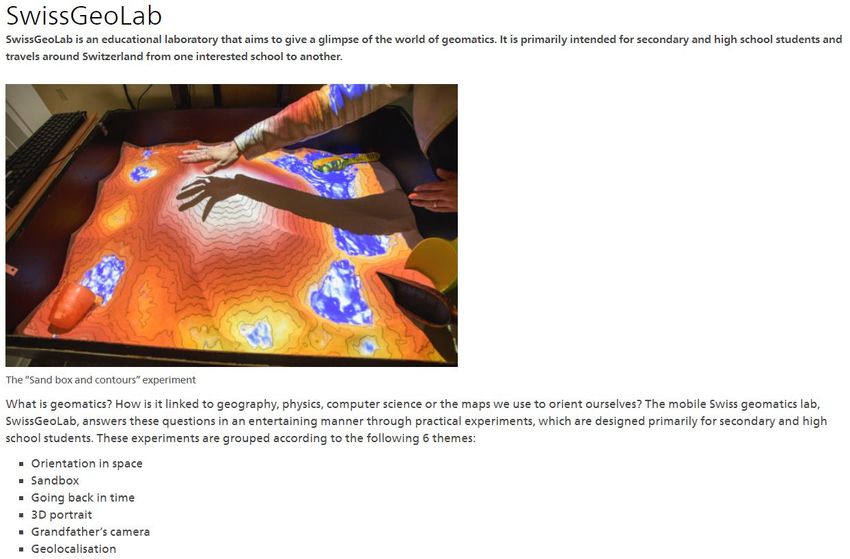
The present publication is the exclusive property of
                           European Spatial Data Research

All rights of translation and reproduction are reserved on behalf of EuroSDR.
Published by EuroSDR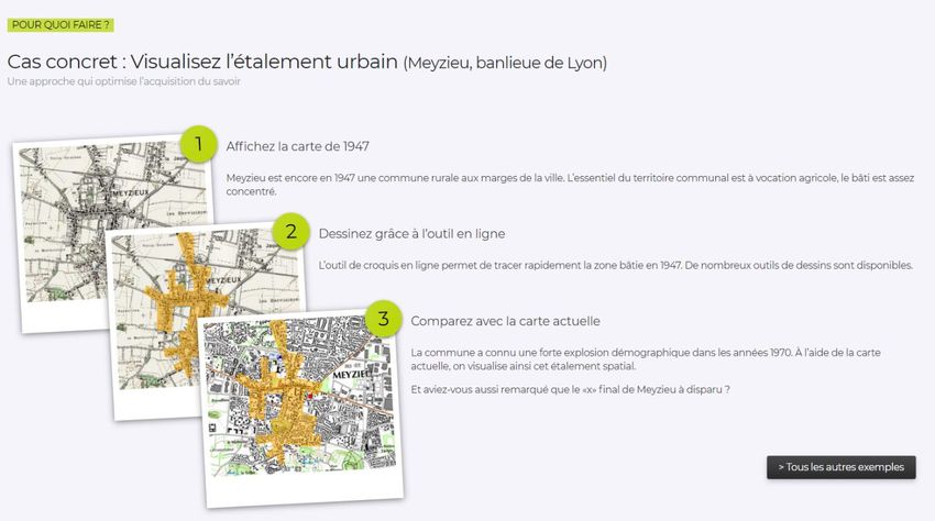
EUROPEAN SPATIAL DATA RESEARCH

PRESIDENT 2020 – 2022:
       Michael Hovenbitzer, Germany

VICE-PRESIDENT 2019 – 2021:
       Fabio Remondino, Italy

SECRETARY – GENERAL 2019 – 2023:
       Joep Crompvoets, Belgium

DELEGATES BY MEMBER COUNTRY:
       Austria: Wolfgang Gold, Gottfried Mandlburger
       Belgium: Eric Bayers
       Croatia: Ivan Landek, Željko Bačič
       Cyprus: Andreas Sokratous, Georgia Papathoma, Andreas Hadjiraftis, Dimitrios Skarlatos
       Denmark: Jesper Weng Haar, Tessa Anderson
       Estonia: Tambet Tiits, Artu Ellmann, Evelyn Uuemaa
       Finland: Juha Hyyppä, Juha Kareinen
       France: Bénédicte Bucher, Yannick Boucher
       Germany: Michael Hovenbitzer, Lars Bernard
       Ireland: Paul Kane, Audrey Martin
       Norway: Jon Arne Trollvik, Ivar Maalen-Johansen
       Poland: Adam Andrzejewski, Krzysztof Bakuła
       Slovenia: Dalibor Radovan, Peter Prešeren, Marjan Čeh
       Spain: Julián Delgado Hernández
       Sweden: Tobias Lindholm, Thomas Lithén, Heather Reese
       Switzerland: André Streilein, François Golay
       The Netherlands: Jantien Stoter, Martijn Rijsdijk
       United Kingdom: Sally Cooper, Claire Ellul

ASSOCIATE MEMBERS AND THEIR REPRESENTATIVES:
      Esri: Nick Land
      Hexagon: Simon Musaeus
      Informatie Vlaanderen: Jo Van Valckenborgh
      nFrames: Konrad Wenzel
      Terratec: Leif Erik Blankenberg
      Vexcel: Michael Gruber
      1Spatial: Dan Warner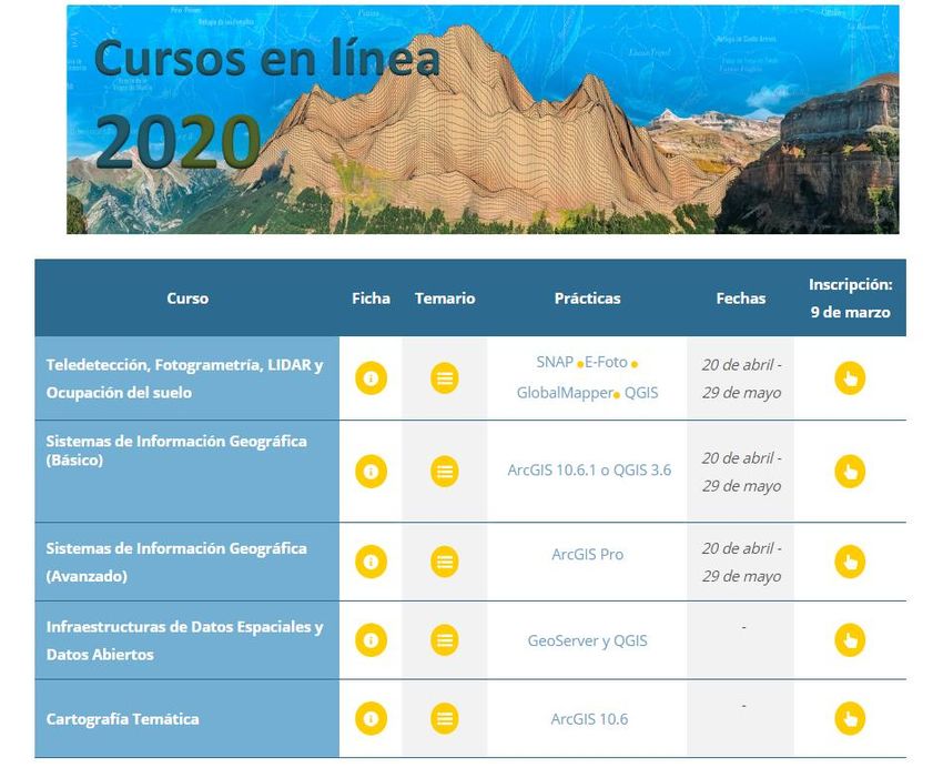
COMMISSION CHAIRPERSONS:
         Data Acquisition: Jon Mills, United Kingdom
         Modelling and Processing: Norbert Haala, Germany
         Updating and Integration: Martijn Rijsdijk, The Netherlands
         Information Usage: Bénédicte Bucher, France
         Business Models and Operation: Joep Crompvoets, Belgium
         Knowledge Transfer: Markéta Potůčková, Czech Republic

OFFICE OF PUBLICATIONS:
         Bundesamt für Eich- und Vermessungswesen
         Publications Officer: Christine Ressl
         Austria
         Contact via EuroSDR secretariat

CONTACT DETAILS:
         EuroSDR Secretariat
         KU Leuven Public Governance Institute
         Faculty of Social Sciences
         Parkstraat 45 bus 3609
         3000 Leuven
         Belgium

         Tel.: +32 16 37 98 10
         Email: eurosdr@kuleuven.be
         Web: www.eurosdr.net

The official publications of EuroSDR are peer-reviewed.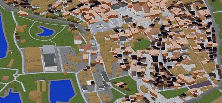
Bucher B., Potůčková M., Crompvoets J.
“EuroSDR Survey: Initiatives for Providing Data and Tools for Research and Education”

Table of contents

Index of Figures ..................................................................................................................................... 6
1      INTRODUCTION ........................................................................................................................... 7
2      OVERVIEW OF THE RESULTS OBTAINED TO THE SURVEY ............................................. 8
    2.1       Generalities.............................................................................................................................. 8
3      DETAILED PRESENTATION OF RESULTS OBTAINED TO THE SURVEY ....................... 10
    3.1       What and for whom ............................................................................................................... 10
    3.2       Partnerships on educational data and tools provision ............................................................ 17
    3.3       Level of Adoption ................................................................................................................. 17
    3.4       Level of maturity/maintenance .............................................................................................. 17
    3.5       Conclusions and perspective ................................................................................................. 17
Acknowledgement ............................................................................................................................... 18
References ............................................................................................................................................ 18
Annexe 1: Questions asked ................................................................................................................. 21

                                                                                                                                                        4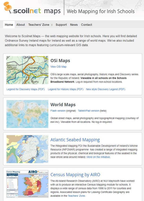
EuroSDR SURVEY:
INITIATIVES FOR PROVIDING DATA AND TOOLS
       FOR RESEARCH AND EDUCATION
                                   With 8 figures

   Bénédicte Bucher a, Markéta Potůčková b, Joep Crompvoets c

                               a
                                    IGN-France
               EuroSDR Commission 4 Information Usage
                          benedicte.bucher@ign.fr

                      b
                          Charles University, Prague
              EuroSDR Commission 6 Knowledge Transfer
                    marketa.potuckova@natur.cuni.cz

                                c
                                    KU Leuven
          EuroSDR Commission 5 Business Models and Operation
                     joep.crompvoets@kuleuven.be

                                                                5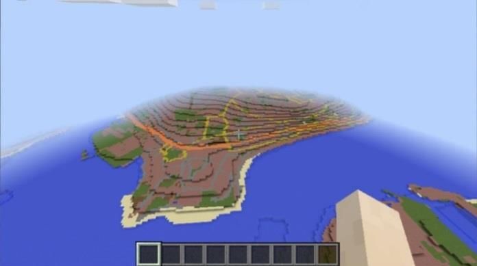
Index of Figures

Figure 1: Map of the initiatives depicted in the survey......................................................................... 8
Figure 2: Homepage of Scoilnet Maps offering digital maps for Irish schools [3]. ........................... 10
Figure 3: Example from IGN France EDUGEO homepage devoted to visualisation of the
              growth of urban sprawl (in French: étalement urbain) [9] .................................................. 11
Figure 4: Homepage of the SwissGeoLab, an educational tool for secondary and
              high school students [10]. .................................................................................................... 12
Figure 5: IGN Spain - offer of e-learning courses for professionals in 2020 [15]. ............................. 14
Figure 6: OSI map data (left) converted into Minecraft block presentation (right) [25]. ................... 15
Figure 7: IGN France web service for generation Minecraft datasets [26]. ........................................ 16
Figure 8: Example of 1 x 1 m resolution Minecraft model of Gotland [28]. ...................................... 16

                                                                                                                                              6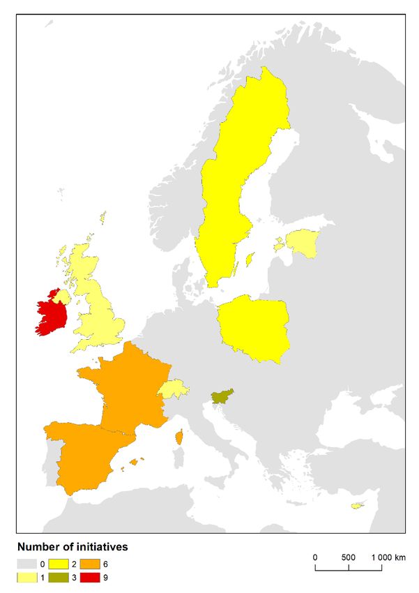
1     INTRODUCTION

Geographical data and analysis are a key asset in different domains of education, from primary school
to high education and life-long learning, and of research like geography, history, urbanism or
environmental science, among others. Engaging with these user communities is part of the mission of
many EuroSDR members. It is also a precious investment to improve data value and reusability.
Firstly, the education community can give relevant feedback on the data usability from their
pedagogical perspectives, scientific users can comment on quality documentation as they need to
adopt a critical perspective on results obtained with data and students learn to use such complex data
before they go into the work force where they may promote their usage. Second, all these users can
help data providers investigate the design of new products to answer emerging needs.
Three commission chairs of EuroSDR (Commission 4 Information usage, Commission 5 Business
models and operations and Commission 6 Knowledge transfer) launched a survey on the provision of
data and tools for research and education purposes on 13th May 2019. The objective of the survey was
to study existing initiatives in terms of practices and projects at EuroSDR organizations to provide
data and tools to pupils, students, teachers, and scientists for research and/or education purposes.
A questionnaire was sent to all the delegates of EuroSDR who represent national mapping and
cadastral agencies (NMCAs). The respondents were asked to describe their potential initiatives by
using a standardized template format, which is in the Annexe 1 of this report. The respondents could
describe as many initiatives as relevant for the provision of their data and tools. The deadline was set
for 1st July 2019. The answers were compiled and reported in a first draft. As the answer rate was
rather low, the draft report was circulated in Spring 2020 again. The first section of this report presents
an overview of the results obtained from this survey and the next section presents them more in details
using the same structure as the questions of the template.

                                                                                                         7
2 OVERVIEW OF THE RESULTS OBTAINED TO THE SURVEY
2.1 Generalities
Responses from 14 organisations were received that depict altogether 32 initiatives mapped on
figure 1.
Figure 1: Map of the initiatives depicted in the survey.
We list hereafter the ten mapping agencies also to introduce their possible acronyms.
- Cyprus (Department of Lands and Surveys),
- Estonia (Estonian Land Board),
- France (National Institute of Geographic and Forest Information – IGN France),
- Ireland (Ordnance Survey Ireland – OSi),
- Poland (GUGiK),
- Slovenia (Surveying and Mapping Authority of the Republic of Slovenia),
- Spain (Spanish National Geographic Institute – IGN Spain),
- Sweden (Lantmäteriet),
- Switzerland (Swiss Federal Office of Topography – Swisstopo),
- and United Kingdom (Ordnance Survey UK – OSGB).
8In addition, other organisations also responded:
- Marine Institute Ireland,
- Geological Survey Ireland,
- Irish Fisheries Board,
- the Warsaw University of Technology
The kind of resources mentioned are mainly data distributed under a specific licence or through a
specific portal. They also include tools to process the data, sensors and specific clients (viewers, story
maps editors). There are also teaching material in the specific domains of competence of the agencies
which range from multimedia documents to animation and a Geolab truck. The portals or platforms
dedicated to education are also used by the education actors to produce and share specific materials in
their domains. Apart from specific licences for research, the engagement with research is mainly done
through collaborative projects or PhD.
Explicitly mentioned domains are: geography, seismology, volcanology, astronomy, economics,
mathematics, physics, computer science, remote sensing, photogrammetry, cartography.
Engaging people is an important aspect in education and the notion of games is often mentioned: the
generation of Minecraft data out of topographic databases, the publication of geogames on agencies
portals and the organisation of escape games on geographic information science.
Last, most organisation operate an open geodata portal for the general public, which can be used by
the education and research community.
93 DETAILED PRESENTATION OF RESULTS OBTAINED TO THE SURVEY
3.1 What and for whom
A diverse range of data and tools for research and/or education purposes are provided. Hereunder, an
overview (with examples) is provided.
Open geodata portals for general public (and therefore available for use in education and/or research)
electronic library of geographic and descriptive information on all real estate in Cyprus [1]
geoportal of the Estonian Land Board [2]
Specific data portfolio and teaching materials for education on Primary, Secondary and University
Level (and research)
OSi: provides a specific dataset (Large scale data, Archived imagery older than 3 years,
Discovery data, Boundary data, Historic mapping, Small scale data, Web services) at no costs
based on the National Mapping Agreement for primary, secondary and university level of
education; through a Map Viewer the system allows access to approximately 450 datasets
from across the public sector under a range of headings such as Agriculture, Environment,
Planning and Development, Geology, Health [3]. Figure 2 shows a section of the homepage of
Scoilnet Maps – a website offering a wide range of maps for Irish schools.
Figure 2: Homepage of Scoilnet Maps offering digital maps for Irish schools [3].
10 Irish Marine Institute: Real Map of Ireland (developed lesson plans for primary school
teachers to use ‘the real map’ in the classroom as a handy learning tool) [4]
IGN Spain: Educational materials for training in the field of geography, cartography,
photogrammetry, remote sensing, seismology, volcanology and astronomy. The materials are
composed of documents, conferences, digital maps, videos, multimedia applications, social
media, smart phones applications. All the content is in Spanish, free and available on the
internet. [5]
OSGB: 21 products covering both Great Britain and Northern Ireland are in the portfolio
under the Educational Services Provider Contract (ESPC). Under the ESPC the sole permitted
purpose is teaching and research and the licensing arrangement ensures that data is free at the
point of use. Different services are available from OSGB partners to reflect user abilities and
needs, i.e. schools and colleges can access simple browser-based mapping which include
essential cartography and analysis tools while advanced college and university users can
access more complex browser-based applications as well as data download facilities. [6], [7]
IGN France: Geocube at School is a project that provide teachers with a toolkit to install a hub
of sensors together with their pupils at the school, to load the data into a global platform
hosting measures from all Geocubes and to use data from this platform. The associated online
map service aims at providing different tools and resources: map, graphs, data processing tools
with the Python interface (in French). [8]
IGN France: On-line service EDUGEO for teachers and students provides different tools and
resources (a wide variety of maps) to draw different thematic maps (historic, economic,
statistics or story maps…), work on them, and register them for class exercise (in French) [9].
Example of a webpage introducing a dataset focused on visualisation of the growth of urban
sprawl on a typical city, shown in Figure 3.
Figure 3: Example from IGN France EDUGEO homepage devoted to visualisation of the growth of
urban sprawl (in French: étalement urbain) [9]
11 Swisstopo: Specific teaching materials are prepared for three education levels:
o For the primary level: materials to help pupils to learn about different types of
geodata, to learn how to read maps and aerial photos and how to use them, to learn the
history of Swiss landscape using historical geodata.
o For the secondary level and high school: a mobile laboratory called SwissGeoLab
aiming to bring the world of geomatics closer to pupils and interested citizens through
experimental teaching methods, experimental techniques for measuring, analysing and
depicting the landscape and showing the connection between geomatics and traditional
areas such as geography, history, mathematics, physics, computer science and the map
applications. There are also collaborations on master thesis as well as data-contract
with universities and teachers for research. [10]
Note that SwissGeoLab material is also used to inform general public about the challenges
posed by new technologies and ways of thinking in the profession of geomatics specialists,
see Figure 4.
Figure 4: Homepage of the SwissGeoLab,
an educational tool for secondary and high school students [10].
Slovenia: E-content, web cartography and geo-multimedia for education of geography and
history are prepared for primary and secondary schools in Slovenia.
Lantmäteriet: Geoskolan is a digital teaching support for teachers and students in primary
schools (age 6 to 15) and secondary schools (age 16 to 19).
Geoskolan contains lesson ideas, a teacher manual and a map application/viewer with geodata
(viewing services) from several public authorities, e.g. demography, groundwater, bedrock,
wells, topographic maps, orthophotos, elevation data, protected areas, relic of the past and
ancient monument, production and industrial facilities. Lesson ideas in Geoskolan have been
12developed based on the knowledge requirements in the syllabuses. Geoskolan is free to use
and available on the internet. [11]
By signing a license agreement schools in different levels can access geodata free of charge
from Lantmäteriet and the Geological Survey of Sweden (SGU) for use in the category of use
called “Research, Education and Cultural Activities”. Researchers and students can access
geodata through a download service. The download service is connected to SUNET, Swedish
University computer Network and use a identify federation called SWAMID, Swedish
Academic Identity Federation. SWAMID includes most universities, university colleges,
research institutions and government agencies that are related to Swedish research and
educational sector. Culture institutions contacts Lantmäteriet or SGU to order and access
geodata. [12], [13]
Warsaw University of Technology: CENAGIS – the "Centre for Scientific Geospatial
Analyses and Satellite Computations – is an advanced IT infrastructure (cyber-infrastructure)
allowing for implementation of geospatial analyses (such as spatial big data with data mining
functionality) and satellite computations. Spatial analyses of large areas, such as the entire
country, regions, opens new opportunities to perform new types of research works. The basic
idea of performed, scientific geospatial analyses is the development of new models and data
analysis algorithms to be used by different industries, services and operations performed by
public institutions. CENAGIS consists of the scientific repository of geospatial data of Poland,
computational centre, and virtual research laboratories with access to open, vector and raster
spatial data, for the entire Poland. As a result of cooperation with partners, access to satellite
imageries of the European Space Agency (ESA) is ensured. CENAGIS provides the
convenient remote access to big sets of spatial data (with the structures developed especially
for scientific purposes), as well as an analytical platform dedicated for scientific analyses will
be ensured. The Centre is open for cooperation in the field of many kind of geospatial
resources, which are being developed in Poland (such as geodetic, road, railway, forest,
geological, agricultural, meteorological, planning, architectural, environmental protection,
defence data) in order to their common processing, analysing and harmonisation. [14]
Professional training
IGN Spain: e-learning courses on GIS, Cartography, SDI, Remote sensing etc. (small fee, in
Spanish) [15]
Copernicus user uptake (mentioned by IGN Spain but runs internationally) [16]
IGN Spain: providing scholarships and 1 to 3 years job after finishing university for preparing
new professionals on spatial data.
IGN France: E-learning courses about geomatics technologies (in French only) [17]
GUGiK Poland: stationary and e-learning free courses focusing on spatial datasets and
functionalities available on national geoportal. Planning training activities and e-learning for
public administration on GIS, SDI and geoportal.gov.pl (in Polish only) co-financed from EU
funds. [18]
13Figure 5: IGN Spain - offer of e-learning courses for professionals in 2020 [15].
Support to teachers
Geological Survey & ESRI Ireland: collaboration with Junior Cycle Teachers (JCT)
Geography to assist teachers with the teaching Geo-literacy skills in the Irish National
Curriculum. JCT Geography is a group of teachers with the responsibility to introduce the new
Geography specification for Junior Cycle (ages 12 – 15 approx.). The programme has a three
(academic) year plan 2018 - 2021 with goals of i) Continuing Professional Development
(CPD) days with a focus on using GSI data and maps from our website in the teaching of
Geography and to encourage students to use it for their Classroom Based Assessment “My
Geography”, ii) Curriculum resource development, iii) Field trip resource development.
Project/theme/research-oriented dataset for general public
The BlueFish Project: The Ireland Wales Territorial Co-operation project for the Irish and
Celtic Sea, focus on climate change, cross border collaboration and community engagement.
[19]
Irish Marine Institute: Ireland’s Marine Atlas (viewer), Seabed Mapping (Interactive Maps,
Downloadable Maps, charts, shipwreck imagery, Google Earth KML files, survey and
research reports, Story Maps, Real Map of Ireland), Shellfish Data Survey (latest shellfish
safety data for harvesting and production maps are based on defined production areas and
results analysed by the Marine Institute), Fisheries Resources Map (viewer and data download
14for sea fisheries species data of the Irish Groundfish Survey and Biological Sampling Survey).
[20]
Specific services for education
OSi: hosting a viewer for the National Council Special Education (NCSE); the viewer is used
to access details about schools all over the country; it contains information about schools with
special classes; it has a search function for teachers and NCSE staff as well as the public
allowing a search by School Roll Number. [21]
Promoting mapping and geographical knowledge
OSi: supporting the Science and Technology in Action activity that annually produce a set of
industry-led lessons, designed to support the teaching of science and related subjects in second
level schools. In 2019 OSi sponsored a worksheet “Ireland’s Sustainable Development – the
impact of maps”. [22]
OSi sponsored Hecatlons (scheduled from 2020): the goal is to promote the use of OSi data
within a linked data environment for research in GIS and related fields by professionals,
academics and those at the leading edge of the GIS industry; it will be open to all (students,
professionals, academics etc.).
Other activities for public rising awareness of geography/geosciences
IGN Spain: Expositions on geoscience and observational instruments
IGN France: Visit of the showroom for young public and professionals, exhibitions in
partnership with the château de Versailles, information meetings for general public,
hackathons, challenges. Escape Game “Enquête de sciences” - 3 different games to understand
geographic information sciences (designed in collaboration with researchers and school).
Digital encyclopaedia of natural and cultural heritage of Slovenia. [23]
Support of people with special needs
Slovenia: Library for the blind and partially sighted users, equipped with tactile maps and
graphics [24]
Data support for (geographic) games
OSi: provides their Prime2 data in a format, which can be read into Minecraft [25], see
Figure 5.
Figure 6: OSI map data (left) converted into Minecraft block presentation (right) [25].
15 IGN Spain: geogames on their educational portal [5]
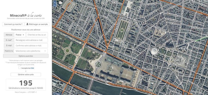
IGN France: On-line service named Minecraft@ on Demand that is designed to provide
Minecraft maps from the geographic data of IGN production. This free web service (see
Figure 7) enables the user to select the centre of the map and to get a Minecraft world
(between 0,5 km and 5km long and 0,5 km to 5km wide, at the scale between 1:1 and 2:1. The
player can easily input this map into Minecraft. [26]
Figure 7: IGN France web service for generation Minecraft datasets[26].
IGN France: in development - a gaming module based on Minetest (free version of Minecraft)
will provide tools to simulate natural risks (floods, rising oceans, eruptions, avalanches, ...)
based on geographic data which are provided by the free service Minecraft@ on demand. [27]
Lantmäteriet: provides open data, in the form of maps for Minecraft covering all 290
municipalities in Sweden. The Minecraft maps are based on Lantmäteriet's national maps and
elevation data. The virtual maps include, for example, details of watercourses, lakes, place
names, roads, railways, land and forest. The maps also include a teleportation feature to make
it easier to find player’s city and its neighborhood. The files with the maps can be downloaded
in resolution 8 x 8 meters per block; the areas of Gotland (see example in Figure 8), Gävle,
Kiruna and Östergötland can be downloaded in the high-resolution of 1x1 meter per block.
[28]
Figure 8: Example of 1 x 1 m resolution Minecraft model of Gotland [28].
163.2 Partnerships on educational data and tools provision
The design and provision of such resources is usually grounded on partnerships between NMCAs and
other organisations. These are: Ministry of Education, Universities, schools, industry (e.g. ESRI,
Hexagon), NMCAs partners e.g. government bodies/departments, national Geological Surveys,
European Space Agency.
3.3 Level of Adoption
If mentioned, then level of adoption is usually quoted as very good. Interesting are numbers provided
by
OSGB:
o Approximate institution subscriptions (individual user numbers):
o Schools – 2,710
o Colleges – 190
o Universities – 120 (annual peak of c. 70,000 active users)
Minecraft@ on Demand:
o Available for 3 years, 51 000 maps delivered (50 maps each day)
eLearning IGN Spain
o Over 600 students per year
Lantmäteriet Sweden, Minecraft
o 28 000 downloads since the start in 2015
3.4 Level of maturity/maintenance
Most of the activities are either regularly updated or new projects under development. Only about 10%
activities do not have any funding for maintenance or are time limited.
3.5 Conclusions and perspective
10 different groups of activities supporting education and research were recognised. The target groups
cover a wide range from pupils at the age of 5 years to university students, professionals as well as
general public. The aims are to teach and improve the geo-literacy, to follow the research and
development in geosciences but also to promote the field towards the public. Important part is to foster
the fields which are based on geographical data like urbanism and but also to support the access and
use of complex data (including geographical data) like climate studies for example. The resources
mentioned have updated to online services and applications which support maps downloading, data
processing and map making, and also to e-learning courses for professionals on different level of
experience. Interesting phenomenon is opening for games adopting real geographical data to virtual
environments. Provided learning materials are usually locally oriented regarding the geographical
location as well as the language but some steps towards international audience have been made (e.g. e-
learning courses or information on the national geoportals in English). Datasets for school and
university education are either open or free of charge under a specific licence agreement (e.g. Ireland,
UK, Switzerland).
17Perspectives can be drawn from this survey for a EuroSDR roadmap on that topic:
Sharing feedbacks on geodata usability for specific applications in these fields. This could be
done thanks to a common questionnaire circulated among users involved in these projects.
Sharing specific tools used or developed for these projects and enhancing the inter-comparison
of these tools and their reusage.
Identifying new resources that could be achieved through a collaboration between European
NMCAs on that topic.
With respect to the last item, there are possible connections with existing EuroSDR groups like the
following:
Eduserv: to provide an Eduserv course on all these resources, on how to access and apply
them, to understand data characteristics and to know where to get information about data
characteristics (metadata).
3D Group: to promote and accompany the usage of 3D.
Historical data: to promote and accompany the usage of NMCAs archives.
Infolab: to support knowledge exchange related to the usage of geodata.
Linked Data: to establish links between national data set portals, to support data discovery and
reusage.
VGI: to support pupils editing data or contributing to scientific data.
Acknowledgement
The authors warmly thank all the contributors to the survey and the reviewers, Heather Reese from
Lund University and Julián Hernández Delgado from IGN-Spain, for their constructive comments on a
first draft.
References
[1] Portal of Department of Lands and Surveys, Cyprus http://portal.dls.moi.gov.cy
[2] geoportal of the Estonian Land Board https://geoportaal.maaamet.ee/eng/Ordering-Data/Open-
Data-for-download-p524.html
[3] OSi
National Mapping Agreement https://www.osi.ie/services/national-mapping-agreement/
Web mapping for Irish Schools https://maps.scoilnet.ie/
[4] Irish Marine Institute, The Real map of Ireland https://www.marine.ie/Home/site-area/irelands-
marine-resource/real-map-ireland
[5] IGN Spain, Educational resources https://www.ign.es/web/ign/portal/recursos-educativos
[6] OSGB licencing agreement in education and research
https://www.ordnancesurvey.co.uk/business-government/licensing-agreements/education-
research
[7] OSGB Digimap https://www.ordnancesurvey.co.uk/education/teachers/digimap-for-
schools.html
18[8] IGN France Geocube www.geobservatory.com/
[9] IGN France Edugeo https://www.edugeo.fr/
[10] Swisstopo educational tools
Teaching material for Primary School (7 – 13 years)
School lesson: „Karten lesen“, in german and french online: https://www.kiknet-
swisstopo.org/deutsch/karten-lesen
Teaching material „Das Geheimnis der Steine“: in german, italian and french online:
https://www.kiknet-swisstopo.org/deutsch/geheimnis-der-steine
Website/teaching material: www.schatz-karte.ch
www.geo.admin.ch/edu (KOGIS) und www.schoolmaps.ch
SwissGeoLab for secundary and high school students (13-15 years)
https://www.swisstopo.admin.ch/en/services/offer-for-schools/cycle-1/SwissGeoLab.html
Collaboration with Master students
https://www.swisstopo.admin.ch/en/swisstopo/training/swisstopo-edu.html
[11] Geoskolan www.geoskolan.se, map application karta.geoskolan.se
[12] Lantmäteriet’s data for research and education
https://www.geodata.se/anvanda/forskning-utbildning-och-kulturverksamheter/
[13] Swedish geoportal https://www.geodata.se/geodataportalen/
[14] Warsaw University of Techology CENAGIS https://www.cenagis.pw.edu.pl/cenagis_eng
[15] IGN Spain e-learning courses https://cursos.ign.es/
[16] Copernicus – the European Union's Earth Observation Programme
https://www.copernicus.eu/en
[17] IGN France e-learning courses http://cours-fad-public.ensg.eu
[18] Head Office of Geodesy and Cartography of Poland (GUGIK)
https://mapy.geoportal.gov.pl/
[19] The BlueFish Project https://irelandwales.eu/projects/bluefish
[20] Educational and research resources of the Irish Marine Institute
Ireland’s Marine Atlas https://www.marine.ie/Home/site-area/data-services/interactive-
maps/irelands-marine-atlas
Seabed Mapping https://www.infomar.ie/maps
Shellfish Safety Data https://www.marine.ie/Home/site-area/data-services/interactive-
maps/select-habs-search-page?language=en
Fisheries resource maps https://www.marine.ie/Home/site-area/data-services/interactive-
maps/fisheries-resource-maps
Digital Ocean http://www.digitalocean.ie/
[21] OSi viewer for the National Council Special Education (NCSE)
https://osi.maps.arcgis.com/apps/MapSeries/index.html?appid=acf128d5d4d94f5bbc04ee91013
9268c
19[22] OSi Science and Technology in Action https://www.osi.ie/wp-
content/uploads/2019/01/A4_OSi-Lesson_14th-Edition.pdf
[23] Digital encyclopedia of natural and cultural heritage of Slovenia http://www.dedi.si/
[24] Slovenian Library for the blind and partially sighted users, equipped with tactile maps
and graphics http://www.kss-ess.si/en/
[25] Creating Ireland in Minecraft https://www.osi.ie/creating-ireland-in-minecraft/
[26] IGN France Minecraft www.ign.fr/minecraft
[27] IGN France Minetest https://www.minetest.net/
[28] Lantmäteriet Sweden Minecraft https://www.lantmateriet.se/minecraft
20Annexe 1: Questions asked
The delegates received the following template to describe their initiatives.
DESCRIPTION OF EACH INITIATIVE
What? (provide a short description of your initiative)
E.g.: license, datasets, maps, digital platform to share pedagogic projects, sensors for teachers and
pupils, minecraft services, escape games to learn to use data, …
Target Group? (describe associated user communities including their level of expertise)
Partnership? (incl. your organization, please describe how associated partnerships are arranged)
Level of adoption? (describe the level of adoption of the relevant data and tools by the target group)
Level of maturity/maintenance? (present the level of implementation maturity of your initiative
including maintenance aspects)
Perspectives? (future developments)
Url, references? – add relevant reference materials related to the data and/or tools of your initiative
21You can also read