Mitigating earthquake risk in Australia - M.R. Edwards, M. Rahman, H. Ryu, M. Wehner & N. Corby - NZSEE
←
→
Page content transcription
If your browser does not render page correctly, please read the page content below
Mitigating earthquake risk in Australia
M.R. Edwards, M. Rahman, H. Ryu, M. Wehner & N. Corby
Geoscience Australia, Canberra, Australia.

M. Griffith & J. Vaculik
University of Adelaide, Adelaide, Australia.

ABSTRACT

Earthquake risk is not limited to tectonic plate boundary countries. While less frequent, significant
earthquakes can occur in intraplate countries like Australia which can have severe consequences.
For Australia this is particularly the case as earthquake hazard has not been recognised in the design
of buildings and community infrastructure for most of the country’s settled history. Significant
risks exist where community assets are by their nature inherently vulnerable to strong ground
shaking. This paper describes three initiatives that are assisting Australian emergency management,
infrastructure managers and local government to prepare for and mitigate these risks.

The first of these highlights how the characteristics of geological hazards differ from severe
meteorological hazards. The very non-linear nature of impact severity with longer average
recurrence interval earthquakes is demonstrated and how this information is supporting emergency
management planning including capacity sharing between Association of Southeast Asian Nations
(ASEAN) countries in the region is described. Secondly, the paper describes how this research is
developing knowledge of the factors behind the vulnerability of critical infrastructure facilities and
the options to mitigate these. The software tool System for Infrastructure Facility Resilience
Analysis (SIFRA) is described which enables infrastructure facility components to be examined in
the context of physical vulnerability, system criticality, repair cost and restoration time. Finally, a
utilisation project of the Bushfire and Natural Hazards CRC working with the local government of
York Shire in Western Australia (WA) is described. The project is providing information on the
effectiveness of targeted retrofit of the heritage town of York to rare earthquakes and how this
action by property owners can be incentivised.

                                               Paper 169
2019 Pacific Conference on Earthquake Engineering and Annual NZSEE Conference                             1
1    INTRODUCTION
Annually Australian communities are impacted by damaging natural hazard events which include severe
storms, floods and bushfires. The regularity of such severe weather related events translates to an increased
awareness of these hazards and, where appropriate, built environment regulation has for many decades
enforced provisions to limit the vulnerability of community assets to minimise the associated risks. This has
not been the case for less frequent earthquakes and the failure to broadly recognise this environmental hazard
in intraplate Australia has resulted in a significant legacy of vulnerable elements in communities which, if
damaged in a rare event, can present catastrophic consequences.
In this paper the nature of earthquake hazard is contrasted with wind hazard in terms of the structural
demands. This difference is further illustrated in scenario modelling undertaken to support emergency
management planning by the Australian Government. The nature of Australia’s vulnerable legacy is
described, including some insights into the transport sector. Collaborative efforts with industry to
understand the related risk and mitigate it are outlined, which has included the application of the tool SIFRA
(http://geoscienceaustralia.github.io/sifra/index.html) to utility facilities. Finally, a research utilisation
project under the Bushfire and Natural Hazards Collaborative Research Centre (BNHCRC) focussed on
earthquake mitigation strategies for buildings is highlighted as an example of a community engaged initiative
to address legacy vulnerability to Australian earthquake hazard.

2    THE NATURE OF INTRAPLATE EARTHQUAKE HAZARD
The severity of the structural demands of earthquake hazard differs from those associated with wind hazard.
In Table 1 the wind hazard for central Perth is presented in terms of a 0.2s gust at a 10m height in level open
countryside for a range of average recurrence intervals (ARIs). In Table 1 these gust wind speeds have also
been translated into the stagnation wind pressure and normalised by the 500 year ARI gust pressure. It can
be noted that the wind loadings increase only gradually with lengthening ARI. Structural loadings for a
storm generating the 2,500 year ARI wind speed in Perth are only 14% greater than those for a 500 year ARI.
In Table 1 this is contrasted with the latest NSHA18 assessed peak ground acceleration (PGA) values for
Perth on rock (Allen et al, 2018) that have been normalised in a similar fashion to the wind loads. The
contrast between the two natural hazards is evident, with the seismic demands of a 2,500 year ARI ground
motion being 2.6 times those of the 500 year ARI hazard. Other Australian state capital factors are larger
with Melbourne 2.7, Sydney 2.8, Hobart 3.2, Adelaide 3.5 and Brisbane 3.6 times larger.
Table 1: Comparison between severe wind hazard and earthquake hazard related structural loadings for the
Perth metropolitan area.

    Average Recurrence        Probabilistic Wind           Normalised Wind                NSHA18
         Interval             Hazard as 0.2s Gust             Loading                Earthquake Loading
          [years]

           100                         38.3                        0.90                       0.32

           250                         39.2                        0.94                       0.63

           500                         40.4                        1.00                       1.00

           1,000                       41.6                        1.06                       1.53

           2,500                       43.1                        1.14                       2.58

           5,000                       44.4                        1.21                       3.77

Paper 169 – Mitigating earthquake risk in Australia
2019 Pacific Conference on Earthquake Engineering and Annual NZSEE Conference                                2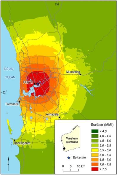
The comparison between the latest understanding of wind and earthquake hazard in Perth illustrates a
fundamental difference between these natural phenomena. Weather systems do not deliver greatly increased
wind loads as the ARI lengthens whereas the earth’s crust delivers steadily increasing severities of ground
motion. This is particularly manifest in intraplate Australia where tectonically derived strain energy, when
released, can deliver proportionately greater shaking severity than that observed at tectonic plate boundaries
(2.6 times greater for Perth versus 1.8 times for Wellington (Standards New Zealand, 2004)). Consequently
rare earthquake events can present catastrophic demands to emergency management and agencies
responsible for supporting recovery.

3    THE ISSUE OF LEGACY
The sporadic nature of damaging earthquakes in Australia has influenced the recognition of earthquake
hazard as a consideration in building design. An Australian design standard for earthquake loadings existed
as far back 1979 (SAA) but it was essentially only used in the two States that had experienced significant
damaging earthquakes prior to its publication; Western Australia (WA) with the 1968 Meckering
Earthquake, and South Australia (SA) with the 1954 Adelaide Earthquake (Griffith 1992). Furthermore,
even in these two jurisdictions the standard was not widely used with application largely limited to some
public buildings. The Newcastle Earthquake of the 28th December 1989 was seminal in the context of this
historical complacency. Clearly, earthquakes could occur anywhere and needed to be considered in the
structural design of buildings and other structures. The first nationally applied loadings standard was
developed and implemented (Standards Australia, 1993) that has since been updated in 2007 and 2018 to
improve its application in building design.
Similar regulatory development has taken place for other non-buildings elements of the built environment,
though with some lag behind building regulations. This is illustrated with the design of bridge infrastructure
in WA. In the last 54 years road bridge design procedures in WA as specified in six succeeding design
documents have developed with a transition from working stress to ultimate limit state design. Earthquake
hazard consideration also progressed, influenced by the 1968 Meckering Earthquake, from having specific
earthquake hazard information in the Yilgarn only to eventually include the balance of WA. Most recently
(Standards Australia, 2017), design standard development has attributed higher importance classes to many
bridges and included displacement based seismic design options. While even the oldest regulations
identified seismic hazard as a consideration, it was not routinely included in bridge design state-wide until
the implementation of AS5100 in 2004 (Standards Australia). This pivotal year of 2004 for seismic design
of road bridges has also been the case for at least one other east coast state that has a similar range of seismic
hazard to WA.
The implication of the parallel histories of building and critical infrastructure design for earthquake as an
environmental hazard is one of legacy. Some Australian buildings and elements of Australian critical
infrastructure are inherently vulnerable to ground shaking, that requires mitigation efforts.

4    EIRAPSI PROJECT
The development of an informed understanding of earthquake risk for buildings and critical infrastructure
has been the focus of a project in WA. The project entitled “Earthquake Impact and Risk Assessment for
Perth and Supporting Infrastructure” (EIRAPSI) is a two and a half year multi-partner project centred on the
Perth Metropolitan region that is developing information, not only for the WA government agencies
responsible for response and recovery, but also for the managers of critical infrastructure in the transport,
electricity and water sectors.

Paper 169 – Mitigating earthquake risk in Australia
2019 Pacific Conference on Earthquake Engineering and Annual NZSEE Conference                                   3
The six project partners are:-
     Department of Fire and Emergency Services            Lead WA Government agency and coordinator of
     the project.
     Geoscience Australia       Technical leader providing risk modelling, infrastructure facility
     vulnerability assessment and project management.
     Global Earthquake Model Foundation          Science partner providing vulnerability and infrastructure
     network modelling support.
     WA Department of Main Roads         Industry partner and collaborator providing transport sector data,
     information and expertise.
     Western Power, WA          Industry partner and collaborator providing electricity sector data,
     information and expertise.
     Water Corporation, WA       Industry partner and collaborator providing water sector data, information
     and expertise.
The project is co-funded by the Global Earthquake Model Foundation (GEM) in Pavia, Italy, and Geoscience
Australia, with in-kind contributions from the other project partners.
Importantly, the role of the industry partners in this project has been an active one. Fundamentally, they are
the experts on the operation of their assets and systems. As well as providing fundamental data, information
and enabling facility inspections, the partners have provided access to their domain specialists to review and
validate the research as it develops. Projects like EIRAPSI enable the bringing together of broader expertise
along the full value chain of earthquake risk science which aids in a broader understanding of earthquake
hazard, community exposure, vulnerability and risk mitigation. The aim is the development of trusted
information that could not be developed by government or industry alone on credible earthquake impacts
beyond present experience.

4.1 Scope
The broad project scope is summarised in Table 2. As can be noted from the table, the project scope covers
the information needs of four industry sectors and a broad range of metrics.

4.2 Hazard
The original scope for EIRAPSI comprised six scenarios. These events were scaled to generate bedrock
shaking levels that matched three hazard likelihoods at two locations of interest as determined at a workshop
with project partners convened on the 27th April 2017. The first epicenter was close to the Western
Australian Cricket Association (WACA) stadium at the eastern end of the Perth central business district, and
the second was close to the community of Mundaring east of the Darling fault. Selected focal depths for the
earthquake events were consistent with the regional geology. The target bedrock hazard was the 2012
bedrock hazard developed by Geoscience Australia (Burbidge 2012) with later refinement underway using
the updated 2018 hazard assessment recently completed by Geoscience Australia (Allen et al, 2018). The
scenario events that matched the 2012 hazard assessment are summarised in Table 3.
Simulated bedrock ground motions corresponded with NEHRP Class B site conditions (Building Seismic
Safety Council, 2004) and so were modified for the effects of regolith response. The process utilised the
national classification of Australian regolith undertaken by Geoscience Australia which has been recently
updated (McPherson 2017).

Paper 169 – Mitigating earthquake risk in Australia
2019 Pacific Conference on Earthquake Engineering and Annual NZSEE Conference                                 4
Table 2: Information development scope of the Earthquake Impact and Risk Assessment for Perth and
Supporting Infrastructure (EIRAPSI) Project.
Industry Sector Metric Category Metric Component or Asset Type
Emergency Management Vulnerability Building damage, including those housing post
disaster functions.
Damaged building triage logistics.
Persons rendered homeless.
Casualties Death and injuries
Urban and Search and Rescue Logistics
Socio-economic Community resilience and recovery needs
Transport Vulnerability and Bridges
Mitigation
Tunnels
Electricity Transmission/Sub- Terminal and switching
transmission
Zone substations
Water Potable Treatment Facilities
Transmission Pumping Pumping stations
All Interdependencies Cross sector
Table 3: Earthquake scenario events matched to Geoscience Australia 2012 assessment of bedrock hazard
(Burbidge et al).
Average Recurrence Target PGA [g] Moment Magnitude Focal Depth [km]
Location
Interval Mw
[years]
Western Australian 500 0.045 4.2 25.0
Cricket Association
1,000 0.080 4.5 20.0
Stadium
(The WACA) 2,500 0.135 5.0 16.0
5,000 0.200 5.4 15.0
Mundaring Weir 500 0.060 4.2 15.0
1,000 0.100 4.5 10.0
2,500 0.175 5.0 8.0
Partway through the project an additional and rarer scenario event was added at the WACA location. This
matched the 5,000 year ARI bedrock hazard and was developed to provide support to the then forthcoming
Paper 169 – Mitigating earthquake risk in Australia
2019 Pacific Conference on Earthquake Engineering and Annual NZSEE Conference 52018 East Asia Summit : International Disaster Assistance Workshop (hosted in Perth from 8 to 10 May, 2018). The simulated surface ground shaking severity in terms of Modified Mercalli Intensity is shown in Figure 1. The region of strong shaking beneath the centre of Perth is very extensive and influenced by the soft alluvial deposits of the Swan and Canning Rivers. The physical consequences of this ASEAN scenario are discussed later. Figure 1: Modelled severity of earthquake shaking on surface soil in terms of the Modified Mercalli Intensity for the 5,000yr ARI hazard matched event centred on the eastern end of the Perth central business district. The simulation of the event predicts extensive areas of the central city experiencing MMI 7.5+ severity shaking. Paper 169 – Mitigating earthquake risk in Australia 2019 Pacific Conference on Earthquake Engineering and Annual NZSEE Conference 6
The scenario events are presently being refined to match the latest bedrock hazard assessed in the NSHA18
probabilistic seismic hazard assessment (Allen et al, 2018) by Geoscience Australia.

4.3 Exposure

The project utilised the National Exposure Information System (NEXIS) developed by Geoscience Australia
as the basic definition of Perth community exposure. NEXIS provides nationally consistent building,
demographic, business and some CI information through the integration of information and data maintained
by other custodians. It also includes information captured by Geoscience Australia through post disaster and
exposure survey work linked to other projects.

The NEXIS derived exposure information was further augmented with specific attributes for buildings
poorly defined or of particular interest to emergency services through the following. The result has been the
most robust that Geoscience Australia has used for a city level study to date.

4.4 Vulnerability
On the basis of available NEXIS information, a total for 31 building types covering three building usages
have been identified and subdivided into two age related vulnerability classes. Earthquake vulnerability
models (18 in total) were mapped to these with a one to many mapping in many cases.
For bridge vulnerability, selections from a suite of 28 US bridge vulnerability models (FEMA 2003) were
utilised in a mapping to the Perth bridge stock. This mapping was subsequently refined through a bridge
sector specialist workshop on 31 August 2018. A similar mapping of US vulnerability models was
undertaken for the 76 electricity substations in the greater Perth area.
For selected key electricity and water sector facilities, specific vulnerability models are being developed and
used to assess current vulnerability and mitigation opportunities. These models are being developed using an
application called System for Infrastructure Facility Resilience Analysis (SIFRA) as described later in this
paper.

4.5 Impact and Risk Assessment
Quantitative impact and risk assessment requires the integration of the elements of hazard, asset exposure and
vulnerability (or susceptibility). The approach used by the project team corresponds with the convolution of
these elements routinely used actuarially in the financial sector, though with a broader range of impact and risk
metrics for this project. The integration tool was OpenQuake, a freely available earthquake impact and risk
assessment software developed by GEM (Silva et al, 2014).
The key impact metrics developed for the three Mundaring centred and four WACA centred earthquake
scenarios are summarised in Table 4. Other impacts were also simulated but not presented here and include
infrastructure and urban search and rescue logistics. It can be noted that exposure has a clear influence. The
respective ground motion hazards are similar for each location but the WACA consequences at each ARI are
several times larger than those for Mundaring Weir due to the greater exposure in central Perth. Secondly, it
can be clearly seen that the severity of the impacts increase significantly with the stepwise increase in the
ARI. This is a direct reflection of the nature of this geological hazard discussed earlier which increases
steadily with increasing rarity, as contrasted with severe wind. Finally, it can be noted that the 5,000 year
ARI logistics are overwhelming with most buildings in the Perth Metro damaged, an enormous triaging
exercise required and 350,000 people requiring temporary housing.

Paper 169 – Mitigating earthquake risk in Australia
2019 Pacific Conference on Earthquake Engineering and Annual NZSEE Conference                                  7
5    ASEAN SUMMIT ON INTERNATIONAL DISASTER ASSISTANCE
Australia is a strategic partner of the 10 member community of the Association of Southeast Asian Nations
(ASEAN). Arrangements exist for these nations to assist one another when a major natural disaster occurs
that exceeds the capacity of the impacted nation to manage. While Australia is able to draw upon its
resources to assist in the region, there is the reciprocal situation in which Australia may be faced with such a
catastrophic event that it needs ASEAN neighbours to quickly assist in key capability areas. The
arrangements for this eventuality were the subject of a summit convened in Perth from the 8th to the 10th of
May 2018 as an initiative between the Australian and Indonesian governments. An earthquake event beneath
Perth occurring in concert with heatwaves and bushfires in the south eastern states and a threatening tropical
cyclone off the Queensland coast was chosen as a backdrop for this summit.
The logistics of the 5,000yr ARI event chosen are presented Table 4 and illustrate the characteristics of rare
earthquakes in intraplate Australia. The underpinning scenario did provide overwhelming consequences for
Australian emergency management in the context of other emergency management demands elsewhere in the
country. This EIRAPSI component provided an evidence based reference against which Australian needs
were assessed in the context of existing arrangements. The outcome of this exercise will be improved
ASEAN support arrangements so Australia can be ready for a catastrophic disaster, including a large
earthquake.

Table 4: Impact metrics for the four WACA centred earthquake scenario events and three events centred on
Mundaring.

    Impact          Mundaring Weir Scenarios                               WACA Perth CBD Scenarios

     ARI         500yr        1,000yr       2,500yr        500yr         1,000yr       2,500yr       5,000yr

Damaged          34,000        83,000       185,000       114,000       186,000       331,000        493,000
Buildings

Building         17,000        42,000        98,000        59,000       100,000       199,000        347,000
Triage

Uninhabitab        140           900          6,400         2,900         8,500        41,000        122,500
le Buildings

Homeless           400          2,500        28,100         8,100        23,800       114,700        345,600
Population

Slightly           60            150           360           220           410          1200          4,050
Injured

Moderately          5            20            120           60            170           800          2,520
Injured

Severely            -             -             -             -             -             5            75
Injured

Dead                -             -             -             -             -            10            140

Paper 169 – Mitigating earthquake risk in Australia
2019 Pacific Conference on Earthquake Engineering and Annual NZSEE Conference                                  8
6 SIFRA Critical infrastructure facilities are complex and incorporate a range of discrete components that must work together in concert to deliver services. The components often have varying vulnerabilities to earthquake ground motion, differ in criticality to the service delivery, have variable costs to repair and can have greatly varying timeframes for restoration. Some of the most vulnerable components can be legacy elements originally built as part of a much smaller facility that was subsequently enlarged to what exists presently. Furthermore, the geographic spread of key components in some facilities can mean that each component does not each experience the same ground motion in a given earthquake event as epicentral distances and soil classes may differ. Some earthquake vulnerability models are available in the literature for complete facility types (FEMA 2003) but these functions for facilities represent broad classes for facilities and provide little insight into the drivers behind overall earthquake risk. Facility information down to component level is fundamental for prioritising any earthquake mitigation efforts. The software application called the System for Infrastructure Facility Resilience Analysis (SIFRA) has been progressively developed at Geoscience Australia to enable critical infrastructure facilities to be analysed from component level up. The software architecture is hazard agnostic enabling other natural hazards, human threats, or technogenic failures to be examined from a component level/system behaviour level. The current application of the tool has been for earthquake vulnerability and is discussed in this context in this paper. The SIFRA model is comprised of four key elements and associated input data: fragility algorithms, facility system model, a loss model, and a restoration model. Each of these is discussed briefly in the following sections:- 6.1 Component Level Vulnerability As earthquake induced ground shaking at a facility increases in intensity, the individual components that comprise it respond and sustain progressively more damage. Fragility functions are typically used to define this susceptibility to damage by quantifying the likelihood that a level of damage will be exceeded for a given level of shaking. This approach requires the definition of one or more earthquake damage states for each component and the selection of a ground shaking measure that is highly correlated to the component damage. In SIFRA up to four sequential damage states have been used for facility component fragility definition. The hazard parameter usually adopted is the peak ground acceleration (PGA) at the site. However, the software can accommodate fragility functions that have other earthquake hazard transfer parameters that may be more correlated to damage of the component in question. For example, peak ground velocity is better correlated to chimney stack damage than PGA. The component level fragility models need to be representative of the assets they characterise. The models used have typically been established by GA using the following hierarchy of reducing certainty:- 1. Direct consultation with industry asset managers to reach agreement on component fragilities using the most appropriate published models and drawing upon construction specifications and observed earthquake performance (if possible). 2. Selection of the most applicable model from a literature survey of published models. 3. Heuristic engineering judgment in adapting damage models for other components assessed to have similar fragility. An example of a fragility function of the second type representing a capacitive voltage transformer (Anagnos 1999) is presented in Figure 2. Paper 169 – Mitigating earthquake risk in Australia 2019 Pacific Conference on Earthquake Engineering and Annual NZSEE Conference 9
6.2 Facility System Model and System Vulnerability

Facilities are interdependent systems and so are modelled in SIFRA as a network of components. This has
three distinct advantages: (1) it allows for modelling the effect of impaired or destroyed components on the
operational capacity of the system, (2) it allows for using graph theory to assess the graduated capacity
degradation (and restoration) through modelling flow through the network, and (3) it allows for detection of
the most efficient ‘paths’, or sets of components, through the network that need to be restored in order to
establish a link between input and output nodes.

Figure 2: Fragility curves for a 230kV capacitive voltage transformer adapted from Anagnos (1999).

The concept of components and facilities used in SIFRA map closely to the typology of micro-components
and macro-components as defined in the European Synerg-G program (Pitilakis et al. 2014), and align with
the definition of subsystems and systems as defined in Rinaldi et al (2001). Under this approach, the
components are represented as nodes. Based on their role within the system, these nodes, or components, are
classified in four general categories; supply, output, dependency or transhipment. These are described in
greater detail in a paper by Rahman and Edwards (2015). The igraph Python package is used as the network
modelling platform to calculate graph metrics for a post-earthquake damaged system model. An example of
a facility translated into a network model is illustrated in the case of an Australian water treatment facility in
Figure 3.

While a component fragility function gives the likelihood that a component will be in a particular damage
state, for the SIFRA analysis of the facility an actual discrete damage state needs to be assigned for each
component. The SIFRA process is run through a Monte Carlo process to sample the damage state of each
component, and for each set of realised component damage states the operational status of the facility is
assessed using the network model. The process is then repeated for a step-wise increasing range of hazard
values (e.g. PGA of 0.01g to 1.40g in 0.01g steps). This process shown in Figure 4 enables a
characterisation of the system in terms of repair cost and facility fragility.

Paper 169 – Mitigating earthquake risk in Australia
2019 Pacific Conference on Earthquake Engineering and Annual NZSEE Conference                                   10
Figure 3: Graph-theoretic system diagram of an Australian water treatment plant. The supply nodes are
shown in green, the dependency nodes are purple, and the output node is orange.

Figure 4: Schematic of the SIFRA Monte Carlo process to attribute component damage associated damage
loss

Paper 169 – Mitigating earthquake risk in Australia
2019 Pacific Conference on Earthquake Engineering and Annual NZSEE Conference                           11
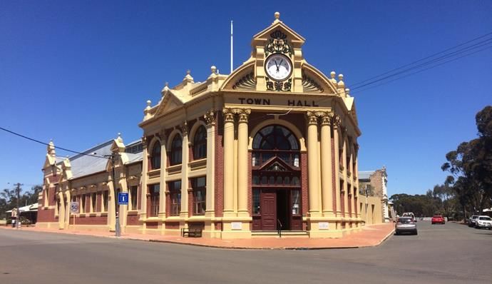
6.3 System Restoration Model
In SIFRA it is assumed that the system restoration process needs to be undertaken in stages, subject to the
level of reparation resources that can be made available and the sequence of repairs. In addition to the core
process of approximating restoration time as outlined above, a routine for simulating component
“cannibalisation” within a facility has also been incorporated. “Cannibalisation” refers to the moving of an
undamaged component from a low priority or redundant line to replace a damaged component on a high
priority line, eliminating potentially long procurement or transportation times and expediting the restoration.
The simulation process enables the fragility of the entire facility to be simulated. It facilitates criticality
analyses with the identification of components with the greatest vulnerabilities, longest restoration times, and
financial losses. This process can be used to undertake virtual retrofits of systems to assess the sensitivity of
facility resilience to upgrades. Most importantly, it can inform investment by industry in mitigation
strategies to make facilities more resilient before a future severe earthquake.

6.4 Application to EIRAPSI Partner Water Sector and Electricity Facilities
The SIFRA methodology is presently being employed to examine three electricity transmission facilities
managed by Western Power. In additional, a major potable water treatment plant with associated water
transmission pumping facilities is being examined with Water Corporation. Facility models have been
developed and currently collaborative effort is being directed at improving the component level information
to improve assessments of system behaviour, restoration prognosis and identify options for mitigating
vulnerabilities. The aim is to assist the managers of critical infrastructure (CI) to identify and address current
vulnerabilities ahead of a major earthquake.

7    YORK MITIGATION STUDY
York is the oldest inland town in Western Australia and is situated approximately 100 kilometres east of
Perth in the Avon Valley. The town has many notable heritage buildings that today attract tourists to the
town, thereby indirectly making a major contribution to the local economy. However, the presence of these
valued older masonry structures in York is “two edged” in that it has also given the town an inherent
vulnerability to earthquake ground motion. Figure 5 shows the York Town Hall built in 1911 which, while
well preserved, has not been the subject of any targeted retrofit to improve its resilience to earthquake ground
motion. The seismic hazard in York is at the threshold of moderate by world standards and the vulnerability
of the community was highlighted in the 1968 Meckering Earthquake that caused widespread damage to
York, located 38km from the epicentre. Earthquake hazard in York is further exacerbated by the soft alluvial
deposits of the Avon River which runs through the centre of town.

Figure 5: York Town Hall located at 81 Avon Terrace.
Paper 169 – Mitigating earthquake risk in Australia
2019 Pacific Conference on Earthquake Engineering and Annual NZSEE Conference                                  12
The vulnerability of York to future credible earthquakes is of concern to the Shire of York which would be
greatly impacted locally, the WA Department of Fire and Emergency Services (DFES) that would need to
respond following an event, and the WA Department of Planning, Lands and Heritage which seeks to
preserve these valuable structures. The interests of local stakeholders have prompted a research utilisation
project under an overarching earthquake mitigation focussed project that is part of the current Bushfire and
Natural Hazards Collaborative Research Centre (BNHCRC). Under Project A9 entitled Cost Effective
Mitigation Strategy For Building-Related Earthquake Risk (https://www.bnhcrc.com.au/research/
understanding-mitigating-hazards/244), a mitigation project led by the University of Adelaide and partnered
with Geoscience Australia is developing earthquake mitigation strategies for masonry buildings in York.
These will be virtually applied to the town to assess the most cost-effective approaches for making six
common building types in York more resilient to future earthquakes.
The project is significant in the matter of preparedness for Australian earthquakes in several areas:-
It is the first time (to the authors’ knowledge) that a community scale approach is being taken to address
legacy earthquake vulnerability in Australia.
The project is considering a very broad range of metrics which include injuries, health care costs and the
impacts on businesses. It is also considering other metrics to better capture avoided intangible impacts.
This element involves a second BNHCRC project that will be providing quantitative measures for these
based on “willingness to pay”.
The project is assessing the effectiveness of mitigation strategies in economic terms as a fundamental
input into what are investments in future resilience.
The project is engaging with the insurance industry that, in the case of York, does not always price
earthquake cover based on locality risk in the same way as it does for bushfire, severe wind and flood.
This has implications for insurance affordability that can impact a community’s ability to recover and on
price signals to promote retrofit action.
The project is seeking to inform strategies for incentivising mitigation action by stakeholders in an
environment where Australian building regulation lacks the retrospective mandates that have recently
been strengthened in New Zealand legislation.
Scenarios for DFES and the Shire are being simulated for present vulnerability and forecast reductions
resulting from retrofit uptake into the future.
The research is being developed to be readily transferable to other Australian communities with
vulnerable masonry buildings, particularly smaller low growth regional towns.
The project will be completed by the end of June 2019. To date the entire town has been surveyed, the
predominant building stock has been reviewed and six key building types have been identified (Vaculik et al,
2018). These types are presented in Table 5 and the selection was endorsed at a stakeholder workshop
convened in York on the 9th August. Further, a range of incentivisation initiatives were identified and
consensus developed on credible uptake rates for building retrofit to enable current and future community
risk to be forecast. Finally, vulnerability models of non-retrofitted and retrofitted buildings are being
developed that enable scalable retrofit measures to be applied to vulnerable elements and the benefits to be
quantified.
Paper 169 – Mitigating earthquake risk in Australia
2019 Pacific Conference on Earthquake Engineering and Annual NZSEE Conference 13Table 5: Selected York building types as representative of common older unreinforced masonry buildings in
small regional towns.
Type Designation Description Image
House Single 3.3m storey, 2 chimneys, no parapets,
veranda on two sides
Pub Two 4m storeys, 5 chimneys, ornate parapets to
two sides, balconies to two sides
Single storey commercial One 4m storey, no chimneys, plain parapet to
one side, propped awning to one side
Two storey commercial Two 4m storeys, 3 chimneys, tall plain parapet
to one side, cantilever awning to one side
Two storey institutional Two 4m storeys, 4 chimneys, no parapet, no
awning
Two storey bank Two 4m storeys, 4 chimneys, medium height
ornate parapet, no awning, numerous small
rooms
8 SUMMARY
In Australia earthquake hazard has been ignored in the development of the built environment for most of the
country’s settled history. Seismic considerations for critical infrastructure have taken even longer to address
with an ongoing need to promote seismic design considerations with other engineering disciplines such as
electrical, mechanical and chemical engineering. Collectively this has led to vulnerable elements being
present in the Australian built environment. These represent a significant risk that needs to be systematically
addressed
It must be noted that, not every community asset is vulnerable to earthquake, with many structure types
either inherently resilient, or having more dominant loading conditions from another hazard, such as cyclonic
wind. Hence, targeted action is the key to addressing those assets that represent the greatest risk, rather than
broad scale initiatives.
Paper 169 – Mitigating earthquake risk in Australia
2019 Pacific Conference on Earthquake Engineering and Annual NZSEE Conference 14Critical infrastructure represents a special risk due to the heavy dependency of communities on transport links and utility service delivery. The interdependency and connectedness of these systems can cause disruption to economic activity and services with footprints much larger and/or extending much further than the area of immediate damage. The value of partnerships between industry, government and other specialists in addressing vulnerability issues has been recognised as reflected in established arrangements for developing and sharing sensitive information to inform mitigation investment. Such partnerships provide insights that cannot be realised by any of these parties in isolation. Earthquake hazard in Australia has characteristics that differ from meteorological hazards and tectonic plate boundary hazard. Rare intraplate earthquakes can be very severe and the consequences beyond the limited experience we have in Australia. As reflected in the reinsurance industry pricing of risk, rare earthquakes can be devastating. Information is needed on existing vulnerability and the most cost-effective strategies to mitigate this. Given the finite resources that are available for retrofit, these strategies need to target those elements of communities that are contributing the most to earthquake risk to get the best outcome for the investment. This information should also draw upon the best available hazard science, including the incorporation of the significant uncertainties that are characteristic of our intraplate environment. Furthermore, this information needs to be communicated in a way that can enable a range of decision makers to make investment decision. Mitigation of the consequences of rare earthquakes can also include enabling emergency management to be better prepared for a rare earthquake. Australian emergency management (EM) has made significant strides in recent years at a range of scales to better plan for future earthquakes. Mitigation for earthquake hazard in Australia is not as advanced as in New Zealand. However, as illustrated by ongoing project initiatives with emergency managers, critical infrastructure operators and local communities with high risk community assets, progress is being made. With the development, communication, incentivisation and uptake of targeted mitigation measures, the next big Australian shake may not be the inevitable disaster otherwise anticipated. 9 ACKNOWLEDGEMENTS The coordinating role of Stephen Gray at DFES, WA, is gratefully acknowledged. The authors also thank co-researchers at GEM, in particular Vitor Silva and John Schneider. The authors also thank industry partners for the EIRAPSI project. In Main Roads these are Adam Lim, Mark Vassiliou and Gavin Johnston. The support of Rudy Van Den Wall Bake in Western Power is acknowledged. In Watercorp, Stephen MacCarthy, Noel Winsor, Jodi Males, Dr Peter Finlay and Stuart Masterson have each made significant contributions. The authors also thank Paul Martin of the York Shire as project partners in the York mitigation study. This paper is published with the permission of the CEO, Geoscience Australia. 10 REFERENCES Allen, T., Griffin, J., Leonard, M., Clark, D. & Ghasemi, H. 2018. The 2018 National Seismic Hazard Assessment for Australia: model overview, Geoscience Australia Record 2018/27, Canberra, doi: 10.11636/Record.2018.027. Anagnos, T. 1999. Development of an electrical substation equipment performance database for evaluation of equipment fragilities, Department of Civil and Environmental Engineering, San Jose State University, San Jose, USA, for PG&E/PEER. Burbidge, D.R. ed. 2012. The 2012 Australian Earthquake Hazard Map, Geoscience Australia Record 2012/71. Building Seismic Safety Council. 2004. National Earthquake Hazards Reduction Program (NEHRP) Recommended Paper 169 – Mitigating earthquake risk in Australia 2019 Pacific Conference on Earthquake Engineering and Annual NZSEE Conference 15
Provisions for seismic regulations for new buildings and other structures, 2003 Edition (FEMA 450), Building
   Seismic Safety Council, National Institute of Building Sciences. Washington D.C.
FEMA. 2003. Multi-hazard Loss Estimation Methodology, Earthquake Model. HAZUS®MH MR3. Technical 546
  Manual, Federal Emergency Management Agency, Washington, D.C. USA.
Griffith, M.C. 1992. Earthquake Simulator Testing of Scale Model Structures, Proc. of Australian Earthquake
   Engineering Society Conference, 1992
Holmes, J.D. 2018. Personal communication, 4 October 2018
McPherson, A.A. 2017. A revised seismic site conditions map for Australia, Geoscience Australia Record 2017/12,
  Canberra, doi: 10.11636/Record.2017.012.
Pitilakis, K., Crowley, H. & Kaynia, A.M. (eds.) 2014. Syner-G: Typology Definition and Fragility Functions for Physical
    Elements at Seismic Risk, Chapter 6, 157-186, Netherlands: Springer.
Rahman, M. & Edwards, M. 2015. A component level approach to the earthquake vulnerability of critical infrastructure
   facilities, Proceedings of the Tenth Pacific Conference on Earthquake Engineering, 6-8 November 2015, Sydney,
   Australia
Rinaldi, S.M., Peerenboom, J.P. & Kelly, T.K. 2001. Identifying, Understanding, and Analyzing Critical Infrastructure
   Interdependencies, IEEE Control Systems Magazine, 0272-1780/01: 11-25.
Silva, V., Crowley, H., Pagani, M., Monelli, D. & Pinho, R. 2014. Development of the OpenQuake engine, the Global
    Earthquake Model’s open-source software for seismic risk assessment, Nat. Hazards 72, 1409–1427, DOI
    10.1007/s11069-013-0618-x.
SAA. 1979. Australian Standard for the Design of Earthquake Resistant Buildings: AS 2121 1979, Standards Association
  of Australia, Homebush, NSW
Standards Australia. 1993. Structural design actions, part 4: Earthquake actions in Australia: AS 1170.4–1993, Standards
   Australia, Homebush, NSW.
Standards Australia. 2004. Bridge design: Design loads, AS5100.2:2004, Standards Australia, Sydney, NSW
Standards New Zealand. 2004. Structural design actions, part 5: Earthquake actions – New Zealand: NZS 1170.5:2004,
   Standards New Zealand, Wellington, NZ, 76 pp.
Standards Australia. 2017. Bridge design: Design loads: AS 5100.2:2017, Standards Australia, Sydney, NSW
Vaculik, J., Griffith, M., Wehner, M. & Edwards, M. 2018. Seismic Assessment of unreinforced masonry buildings in a
   heritage-listed township, Proc. of Australian Earthquake Engineering Society 2018 Conf., Nov 16-18, Perth, W.A.

Paper 169 – Mitigating earthquake risk in Australia
2019 Pacific Conference on Earthquake Engineering and Annual NZSEE Conference                                        16
You can also read