MONITORING OF HIGH RISE BUILDING USING VERY LONG FOCAL LENGTH OF CAMERA LENS AND THREE DIMENSIONS GOOGLE IMAGES
←
→
Page content transcription
If your browser does not render page correctly, please read the page content below
Journal of Engineering and Sustainable Development Vol. 23, No. 01, January 2019 www.jeasd.org (ISSN 2520-0917)
Vol. 23, No.01, January 2019
ISSN 2520-0917
https://doi.org/10.31272/jeasd.23.1.1
MONITORING OF HIGH RISE BUILDING USING VERY LONG
FOCAL LENGTH OF CAMERA LENS AND THREE DIMENSIONS
GOOGLE IMAGES
Dr.Entisar Kadhim Al-Geelawe1, Dr.Layth Sadek Mohsin2
1) Assistant Prof., Civil Engineering Department, University of Baghdad, Baghdad, Iraq.
2) Lecturer Civil Engineering Department, Mustansiriyah University, Baghdad, Iraq.
Abstract: A new approach of monitoring of building tower of University of Baghdad has been
implemented through the use of accurate cameras which include Sony camera )a65( with GPS and two
zoom lenses (18-55mm &55-200mm) as well as MTO 1100mm 10.5 mirror lens mounted on Pentax K-x
camera. The positions of damages were located on three dimensions (3D) Google images; therefore it has
been dispensed with the use of original drawings which are often lost or missing.
Keywords: : Monitoring, damages, binoculars, Pentax K-x DSLR camera, GPS, focal length, MTO lens,
3D Google images.
رصذ بناية شاهقة باستخذام عذسة كاميرا رات بعذ بؤري كبير جذا وصور كوكل ثالثية االبعاد
Sony حن حٌفيذ اسلىب حذيث في رصذ بٌايت البزج في جاهعت بغذاد هي خالل اسخخذام الكاهزاث الذقيقت والخي حخضوي كاهزة:الخالصة
والوزكبتMTO 1100mm 10.5 هلن) وكذلك عذست هزاة022 -55هلن و55 -81( ) هع ًظام ححذيذ الوىاقع العالوي هع عذسخييa65(
ولهذا حن االسخغٌاء عي اسخخذام الوخططاث, ثالثيت االبعادGoogle حن حثبيج هىاقع االضزار على صىر.Pentax K-x على كاهزة
.االصليت والخي غالبا ها حكىى هفقىدة او ضائعت
1. Introduction
The monitoring process is periodically required for each construction to maintain its
performance, safety and to increase its useful life. The monitoring of high rise building
is not an easy process as it should be monitored from a long distance that requires
special preparations to use very long focal length of camera lens where the main causes
of preparations related to qualified and most suitable tools to detect such distant and
small damages can be detected.
In Reference [1] it was explained the importance of digital camera, binoculars and
some other tools in the measurement and documentation in visual inspection for
structural Integrity of building at risk in which cracks of width 0.75mm to 31.5mm were
documented because of differential settlement induced by inadequate foundations.
In [2] Kodak camera DSC 660 was used with a six-megapixel (3000 x 2000)
resolution with a lens of focal length 28-mm for similar monitoring process.
*Corresponding Author: laiths66@uomustansiriyah.edu.iq
1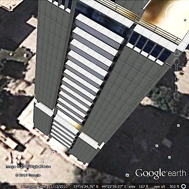
Journal of Engineering and Sustainable Development Vol. 23, No. 01, January 2019   www.jeasd.org (ISSN 2520-0917)

Also in [3-5] a modern approach of visual inspection was applied using Global
positioning System (GPS) and high resolution DSLR cameras with a 600mm long focal
length lens for inspection of bridge and large structures (Dams and Cooling Towers)
respectively.
   The building tower of University of Baghdad has been selected for monitoring
process as it is considered as the tallest building in Baghdad which has been subjected
to some projectiles from the east after the events of 2003 and there are some concerns
about the presence of expanded cracks and also there may be the possibility of the fall
of small pieces later.

2. Preparations and Selection of Tools
    It is important for any construction that has to be monitored to make some required
preparation to select the locations in which the construction would be inspected as well
as the tools that are appropriate for inspection from such location and after some
attempts in which binocular has been used to visually inspect such damages, it was
concluded that the most suitable location of monitoring such distant and small damage
is from a distance of about 60 meters away from the building. Monitoring of high rise
building from such distance requires special tools which include very long focal length
of camera lens, accurate digital camera with the capability of image stabilization as well
as steady tripod. The selection of tools can highly affect the quality of the images. The
lighting condition of the damages surface can also affect the quality of such images.

3. Needed Tools and Results
   The damages first were inspected by binocular (20x60) to identify their locations
with respect to their floor level as shown in Fig.1.

                                                    Fig. 1 Binoculars 20x60.

  It is important to highlight the attention and the aesthetic of the tower building, thus
Sony a 65 camera was used (as shown in Fig.2) which is a Digital Single Lens

                                                                  2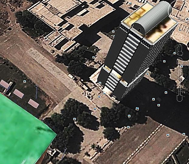
Journal of Engineering and Sustainable Development Vol. 23, No. 01, January 2019   www.jeasd.org (ISSN 2520-0917)

Translucent (DSLT) camera that has 24MP with The Global Positioning System (GPS)
that can determine the site location which based on satellite navigation system.

                                                    Fig. 2 Sony a65 camera.

  The longest focal length that can be found is 1100mm with F10.5 for MTO lens
which is mirror lens (as shown in Fig. 3).

                                         Fig. 3 MTO mirror lens (1100mm, 10.5).

   MTO lens was mounted to Pentax K-x which is a DSLR camera with 12MP and has
image stabilization in its sensor which is important to prevent any blurred that is related
to such magnification power of the lens. The magnification power is very high, thus a

                                                                  3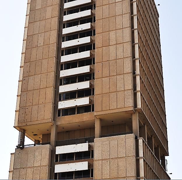
Journal of Engineering and Sustainable Development Vol. 23, No. 01, January 2019   www.jeasd.org (ISSN 2520-0917)

tripod is essential to minimize any hesitations or vibration caused by carrying the
camera by hand and also a remote control was used to minimize the small vibration
shock caused by pushing the shutter release bottom (as shown in Fig. a and b).

                                                                 A

                                                                 B
                Fig. 4 (A & B) Pentax K-x camera mounted with MTO 1100mm lens on a tripod.

   The camera was placed at an estimated distance of about 60m from the tower of
university of Baghdad while the inspected damages were at estimated heights of about
25-60m above the ground.

                                                                  4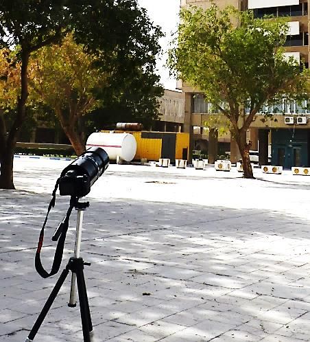
Journal of Engineering and Sustainable Development Vol. 23, No. 01, January 2019         www.jeasd.org (ISSN 2520-0917)

   The aesthetic of an image depends on focal length of the lens, camera position and
lighting condition (see Fig 5). In Fig. 5A the image was taken from the ground where
the effect of perspective view indicates a taller tower than an actual due to the effect of
vanishing lines that are not normal with the base. While in Fig. 5B, the image was taken
from second floor that making the tower seems in normal perspective view.

A                                                            B
                                 Fig. 5 (A&B) Building tower of University of Baghdad.

    The aesthetic of perspective view depends on focal length of lens, camera position
and lighting condition (see fig 5 A and B). In fig. 5A the image was taken from the
ground where the effect of perspective view indicates a taller tower than an actual due
to the effect of vanishing lines that are not normal with the base. While in Fig. 5B, the
image was taken from second floor that making the tower seems in normal perspective
view.

                                                                  5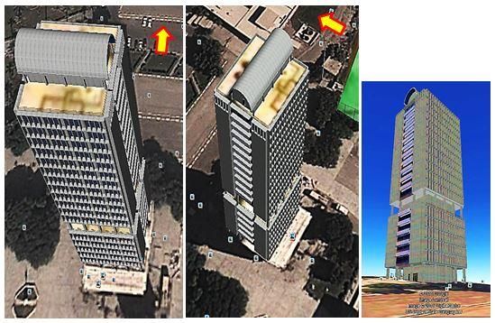
Journal of Engineering and Sustainable Development Vol. 23, No. 01, January 2019 www.jeasd.org (ISSN 2520-0917)
4. Damage location in Three Dimensions (3D)
The location has been identified by the binoculars, and then the digital camera Sony
a65 was used to identify the coordination of GPS service which determined the
coordinates of the location which are used to find the related place from Google images.
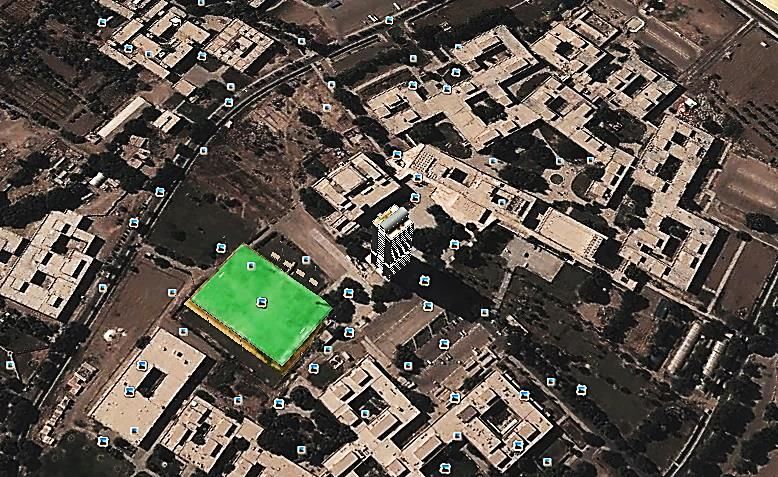
Google Earth offer 3D images for some high rise and distinguishing constructions
such for tower building of University of Baghdad which can be used to locate the
damage clearly as shown in Fig. 6 (A & B).
The colored arrows show the direction of the images that covered the damages at the
east side of the tower (red arrow).
The location is identified by GPS coordinates as shown in the Fig. 7 with respect to
the latitude and longitude.
The locations of the damages are clearly presented at 3D view of Google map as
shown in Fig. 7.
It is clear from this figure that upper parts of the tower are clearer than lower parts
because the image was taken from the top on the contrary on that shown in figure 8
where the image was taken from the bottom and all damages were marked with a
colored circle code for each damage.
The lower parts of the building damages can be clearly presented on the normal
building images as shown in Fig.8
The damages caused by projectiles are shown in figure 9 for heights between 25-45
m while in Fig. 10 the damages for heights 55-60 m are shown according to their
colored circle code.
The sub image that has colored rectangular code was taken from the enlargement of
the part of the original image.
The perspective view of a construction in Google 3D map offer many advantages as
shown in Fig. 11 which are:
1. It can offer more details in upper parts than any other images. Such images
cannot be taken by normal ways.
2. The perspective view can be rotated and shifted to any direction to show its
front, side and any other views.
3. The ability to show any details at any angle of view simply, clearly and without
missing any other details.
4. The use of 3D Google images also presents the geographic position and
direction of the building with respect to the North or any direction by presenting
the accurate horizontal angle with respect to its direction.
6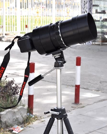
Journal of Engineering and Sustainable Development Vol. 23, No. 01, January 2019        www.jeasd.org (ISSN 2520-0917)

A

                                                                  Camera location

B

                                  Fig. 6 (A & B) Google map of University of Baghdad.

                                                                  7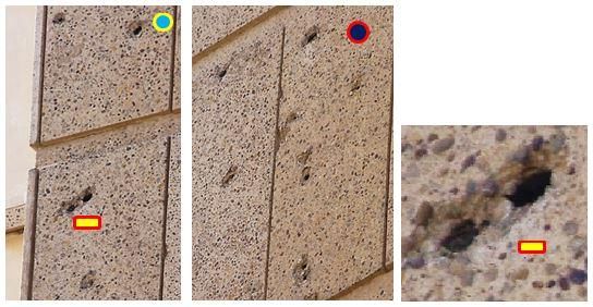
Journal of Engineering and Sustainable Development Vol. 23, No. 01, January 2019   www.jeasd.org (ISSN 2520-0917)

Fig. 7 Google 3D view of the tower of University of Baghdad where the projectile damages are presented
 by colored circles and irregular opening in the roof presented by colored triangle (The image includes
                      coordinates of the location which show latitude and longitude.

                                                                  8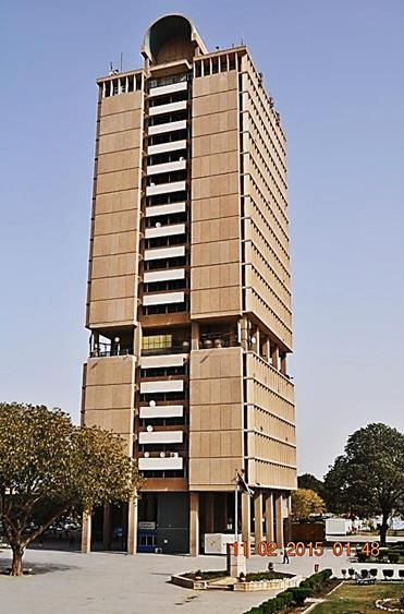
Journal of Engineering and Sustainable Development Vol. 23, No. 01, January 2019   www.jeasd.org (ISSN 2520-0917)

   Fig. 8 Image of the Tower of University of Baghdad which has projectile damages that presented by
                                              colored circles.

                                                                  9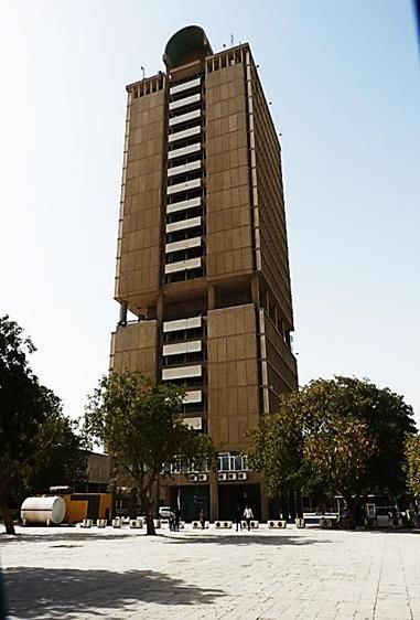
Journal of Engineering and Sustainable Development Vol. 23, No. 01, January 2019   www.jeasd.org (ISSN 2520-0917)

 Fig. 9 Damages caused by projectiles at an estimated height of 25-45m (Pentax K-x with MTO 1100mm
                                                  10.5).
Note: Damage in A is an irregular opening in the roof (is not caused by projectile, it may be caused by
maintenance work).

                                                                 10
Journal of Engineering and Sustainable Development Vol. 23, No. 01, January 2019 www.jeasd.org (ISSN 2520-0917)
A B
Fig. 10 Damages caused by projectiles at an estimated height of 55-60 m
(Image A by Pentax K-x with MTO 1100mm & image B by Pentax K-x with 55-300mm).
1 2 3
Fig. 11 Google different views of the tower of University of Baghdad (the perspective can be viewed,
shifted and rotated at any angle even from ground level as in 1, 2, &3).
11Journal of Engineering and Sustainable Development Vol. 23, No. 01, January 2019 www.jeasd.org (ISSN 2520-0917)
5. Conclusions
It has been approved that using such approach was very successful and will reduce
time and efforts due to their activity, accuracy and easiness of both damages
recognition or identification of damages location when measured with respect to the
traditional method.
The new approach of monitoring process was essential to solve the problem of
missing drawings and plans of the site.
Google images are very useful and present clearer details than original drawing
(which are usually missing) or any other drawings or maps and also easier to find
locations of damages especially when used with colored arrows that present
positions and directions of images of the damages.
6. References
1. Ehiorobo J.O, et al, (2013). “Measurement and Documentation for Structural
Integrity Assessment of In-Service Building at Risk.” International Federation of
Surveyors.
2. White K., et al, (2005). “HIGHWAY BRIDGE RESEARCH CENTER FINAL
REPORT— PHASE I”, Bridge Research Center, New Mexico State University, the
U.S. Department of Transportation Federal Highway Administration.
3. KAMADA T., et al, (2013). “THE GPS CAMERA APPLICATION FOR THE
EFFICIENCY”, 11th September, Department of Civil Engineering, Shibaura
Institute of Technology, Japan.
4. Camp G., et al, (2013). “LARGE STRUCTURES: WHICH SOLUTIONS FOR
HEALTH MONITORING?”, 2-6 September, International Archives of the
Photogrammetry, Remote Sensing and Spatial Information Sciences, International
CIPA Symposium, Volume XL-5/W2, XXIV Strasbourg, France.
5. PIOT S., LANÇON H., (2012). “New Tools for the Monitoring of Cooling
Towers”, 6th European Workshop on Structural Health Monitoring - Tu.4.B.3.
12You can also read