Mount Everest Lukla - Steam
←
→
Page content transcription
If your browser does not render page correctly, please read the page content below

Lukla
Mount Everest

    Manual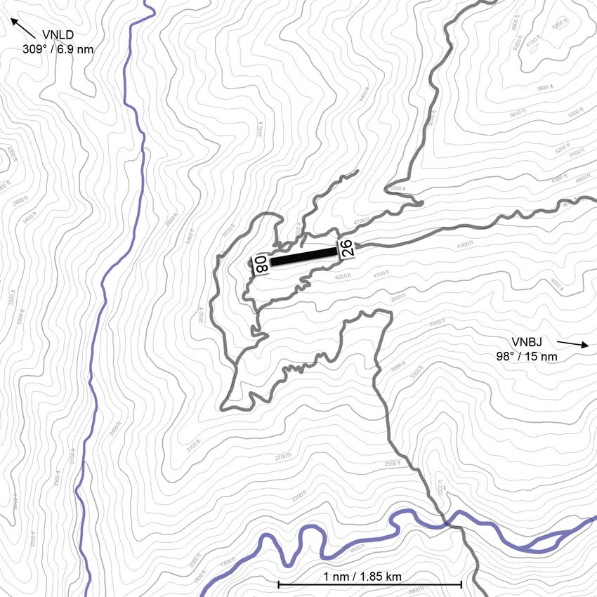
Lukla – Mount Everest – Extreme

   Concept:                    Sascha Normann
   GIS:                        Sascha Normann
   Modeling/texturing:         Sascha Normann
   Project Management:         Sascha Normann
   Manual, documentation:      Sascha Normann, Aerosoft

                                                                      Lukla
                                                                 Mount Everest – Extreme

                                                                         Manual

   Copyright:    © 2019 / Aerosoft GmbH
                 Airport Paderborn/Lippstadt
                 D-33142 Büren, Germany
                 Tel: +49 (0) 29 55 7603-10                               Add-on for
                 Fax: +49 (0) 29 55 7603-33
                 E-Mail:      info@aerosoft.de
                 Internet:    www.aerosoft.com
   All trademarks and brand names are trademarks or registered           Aerofly FS 2
   trademarks of their respective owners. All rights reserved.
                                    2                                          3
Aerosoft GmbH 2019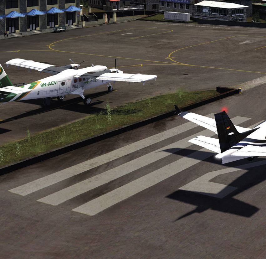
Lukla – Mount Everest – Extreme

   Content                                                                                                Starting Off
   Starting Off................................................................5
           Introduction........................................................................... 5      Introduction
           System Requirements............................................................. 6
           Support.................................................................................. 6    “Gateway to Mount Everest” and “World’s Most Dangerous Airport”;
           How To Get Started................................................................ 7           certainly the most commonly used attributes for an airport that seems
           Settings.................................................................................. 8   out of this world. But it’s not only about Lukla; there’s much more to
           Overview Maps....................................................................... 9         this package...
                  General Map............................................................... 9
                                                                                                          Truth be told: There are airports that are higher (see Tingri included in
                  Core Area Map......................................................... 10
                                                                                                          this package). There may be airports that have a shorter runway.
                  Coverage Map.......................................................... 11
                                                                                                          There even may be airstrips somewhere that have an even worse
           Airports And Maps............................................................... 12
                                                                                                          upwards slope of the runway. Or others that have a mountain wall at
                  VNLK Lukla (Tenzing Hillary Airport)........................... 12
                                                                                                          the end of their runway. What makes Lukla standing out is its
                  VNSB Syangboche..................................................... 18
                                                                                                          combination of all those factors in one single airport!
                  VNPL Phaplu............................................................. 21
                  VNRT Rumjatar.......................................................... 25              Not enough thrill for you? Count in weather as a factor. No naviga-
                  VNKL Kangel Danda.................................................. 27                  tional aids. Limited documentation of approach and takeoff routes.
                  VNBJ Bhojpur............................................................ 29             An uncontrolled airpace with fixed wing aircraft and helicopters.
                  VNJI Jiri..................................................................... 31
                                                                                                          You want more? Bring your engines (and brakes!) to their limits by
                  VNLD Lamidanda...................................................... 33
                                                                                                          heading up the valley to Syangboche, an even higher located bumpy
                  VNKD Man Maya Khanidanda................................... 35
                                                                                                          airstrip surrounded by rocks high above a steep valley. Or try to find a
                  VNRC Ramechhap..................................................... 37
                                                                                                          helicopter that can reach even higher located helipads or even land at
                  VNTJ Taplejung (Suketar)........................................... 39
                                                                                                          the Mount Everest basecamp, located right next to sharp glacier
                  VNTR Tumlingtar....................................................... 41
                                                                                                          pinnacles between rock outcrops.
                  ZUTG Tingri............................................................... 43
                                                                                                          Fly out of Tumlingtar in larger jets to explore the highlands of Tibet
   Technical Advice......................................................45                               without having to worry about international borders. Bring airliners to
           Flight Routes To Lukla........................................................... 45           their limits when taking off from the to be built airport of Tingri. Or
           3rd Party Add-on Sceneries................................................... 46               simply enjoy the landscape while flying passengers and cargo
                   Kathmandu............................................................... 46            between many small airfields (all of them challenging) within a
                   Incompatible Sceneries.............................................. 46                massive coverage area of 200x200 kilometres.
           Folder Structure.................................................................... 47
           Known Issues (FAQ).............................................................. 48            This package will replace “Lukla X – Mount Everest” by the same lead
                                                                                                          developer. One of our most popular sceneries of the past decade that
   Credits......................................................................50                        has won many awards – among them the Simflight Award. This new
                                                                                                          version is a completely new development setting the bar even higher
   Copyrights................................................................51                           again, coming with much more content than the previous version.
                                               4                                                                                               5
Aerosoft GmbH 2019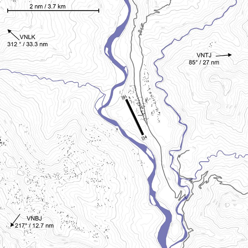
Lukla – Mount Everest – Extreme

   System Requirements                                                      How To Get Started
      •   Operating System: Microsoft Windows 7 / 8 / 10 (64bit)            After installation, simply run Aerofly FS2. Select “Location”:
      •   Processor: Dual-Core, 2,4 GHz (Quad-Core, 3,0 GHz recom-
          mended)
      •   Memory: 4 GB RAM (8 GB recommended)
      •   Graphics card: 2 GB VRAM, OpenGL 4.5
      •   Free hard disk space: 8 GB

   Support
   Support for this product is done by Aerosoft. We prefer to do support
   on the support forum for one simple reason, it is fast and efficient
   because customers help customers when we are sleeping.
      •   Support Forums: http://forum.aerosoft.com
                                                                            Zoom into the highlighted Himalayas area (yellow marker) until
      •   If you prefer support by email: https://helpdesk.aerosoft.com/    airports become visible:
          portal/newticket
   Please note that email support can be slow when things are busy
   (shortly after a major release for example). We try to get back to you
   in 24 hours, but if you want an answer fast, go to the forums.
   We feel strongly about support. Buying one of our products gives you
   the right to waste our time with questions you feel might be silly.
   They are not. We offer support in English, German, Dutch, French,
   Spanish and Portuguese.

                                    6                                                                            7
Aerosoft GmbH 2019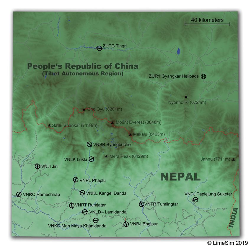
Lukla – Mount Everest – Extreme

   Select the airport/helipad of your choice (note that helipads can only
   be selected if you selected a helicopter previously):
                                                                            Overview Maps
                                                                            NOTE: Alternatively to these maps you can use the Google Earth™
                                                                            KMZ file available with this scenery. You will find it in your Windows
                                                                            Start menu.

                                                                            General Map

   Settings
   For best visuals maximum settings are recommended, provided your
   hardware permits you to do so:

                                    8                                                                            9
Aerosoft GmbH 2019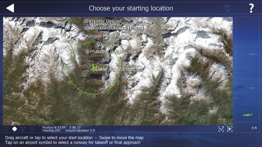
Lukla – Mount Everest – Extreme

   Core Area Map                       Coverage Map

                                  10                  11
Aerosoft GmbH 2019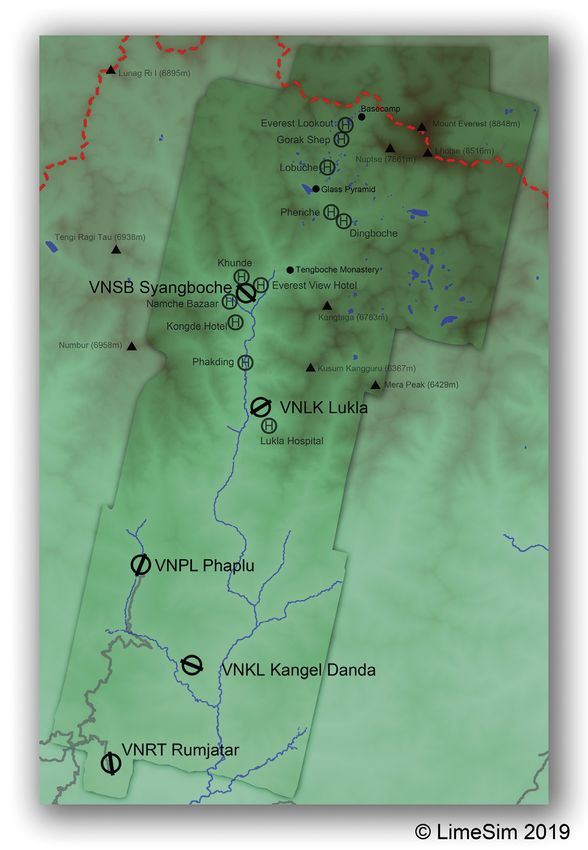
Lukla – Mount Everest – Extreme

   Airports And Maps                                                           There are daily flights between Lukla and Kathmandu during daylight
                                                                               hours in good weather. Although the flying distance is short, rain
   NOTE: All information provided in this manual is for flight simulation      commonly occurs in Lukla while the sun is shining brightly in Kath-
   use only and is not intended for use in real world aviation!                mandu. High winds, cloud cover, and changing visibility often mean
                                                                               flights can be delayed, or the airport closed.
                                                                               Lukla is not connected to the nation’s road network and only
                                                                               accessible by foot or air. Yet it is a place buzzing with tourists, small
                                                                               scale accommodations, cafés, Wi-Fi hotspots, Sherpas and everything
                                                                               else a modern tourist needs. Called “The Gateway to Everest”, it is
                                                                               Lukla where most people start their ascend to Mount Everest. Most
                                                                               climbers and their equipment are flown to the airport in March/April
                                                                               to get acclimatized to the thin air. Once acclimatized they move on to
                                                                               the final push to Everest in April/May. October is the best time for
                                                                               viewing mountains and this is when most not-so-adventurous tourists
                                                                               are flown in in large numbers.
                                                                               The airport is not only used for passenger flights, but also for
                                                                               transporting most of the building material and cargo to the town, as
                                                                               most of the roofs on the houses at Lukla have to be transported by
                                                                               aircraft.
   Nepal is a country where only limited documentation about the
   individual airports is available. There have, however, been consider-       In 1964 it was the legendary Sir Hillary and his Himalayan Trust who
   able improvements in the past decade. The information here has been         were looking for a flat patch of land to build an airstrip as close as
   gathered from various sources including a pilot flying in the area.         possible to Mount Everest. As it seemed impossible to find a place flat
                                                                               and long enough, they finally decided on a patch of land for sale in
   Due to the lack of up-to-date to-scale charts for the airports we
                                                                               the little village of Lukla. Hillary described the construction of the
   decided to create our own charts and added approach and safety
                                                                               airfield in more detail in his memoirs “View from the Summit”.
   information where those were available.
                                                                               It wasn’t until 2001 that the runway was paved. In January 2008, the
                                                                               airport was renamed in honour of Sherpa Tenzing Norgay and Sir
   VNLK Lukla (Tenzing Hillary Airport)                                        Edmund Hillary, the first people confirmed to have reached the
   Lukla is without a doubt the star of all airports in the area! Likely the   summit of Mount Everest, and also to mark their efforts in the
   worst sloped runway and a mountain wall at the end makes last               construction of this airport.
   minute go-arounds impossible. In addition to that there is unpredict-       Due to the difficulties of successfully landing at the airport, the Civil
   able mountain weather and it is buzzing with scheduled fixed wing           Aviation Authority of Nepal sets high standards: Only experienced
   and helicopter traffic in a very small area. Legend has it that planes do   pilots, who completed at least 100 short-takeoff-and-landing (STOL)
   not need to take off properly; they just need to fall off the end of the    missions, have over one year of STOL experience in Nepal and
   runway to gain enough speed to fly.                                         completed ten missions into Lukla with a certified instructor pilot, are
                                                                               allowed to land at the airport.
                                    12                                                                               13
Aerosoft GmbH 2019
Lukla – Mount Everest – Extreme

                                                             Operation hours            Jan, Feb, Nov, Dec: 06:45-18:00 local time
                                                                                        Mar, Apr, Sep, Oct: 06:15-18:30 local time
                                                                                        May, Jun, Jul, Aug: 06:00-18:45 local time
                                                             Start of operations:       1964
                                                             Servicability:             All weather
                                                             Fuel                       - not available -
                                                             Rescue and fire fighting   ATV with limited fire fighting equipment
                                                             services
                                                             Navigation                 - not available -
                                                             Coms                       HF SSB: 5805.5 (not applicable for Aerofly FS2)
                                                                                        VHF: 122.3 (not applicable for Aerofly FS2)
                                                             Metereological info        Yes (tower observation)
                                                             Services                   AFIS
                                                                                        VFR
                                                             Ground transportation      - not available -
                                                             Type of aircraft           D228, DHC6, L410, Y12, C208

                                                             Runway:

                                                             Type of surface            Bitumen
   VNLK Lukla – General Information:                         Runway dimensions          527 x 20 meters

    Name                   Tenzing Hillary Airport (Lukla)                              12.99% upslope from rwy 06

    ICAO code              VNLK                              Runway designation         24/06

    IATA code              LUA                               Apron                      1 bitumen apron at upper end of rwy

    Coordinates            N27.41.1 E86.43.5                                            1 unsealed area north center of rwy with
                                                                                        additional parking usually reserved for
    Elevation              2851.688 m / 9356 ft                                         helicopters.
    Operational            Yes                               PAPI                       - not available -

                                  14                                                               15
Aerosoft GmbH 2019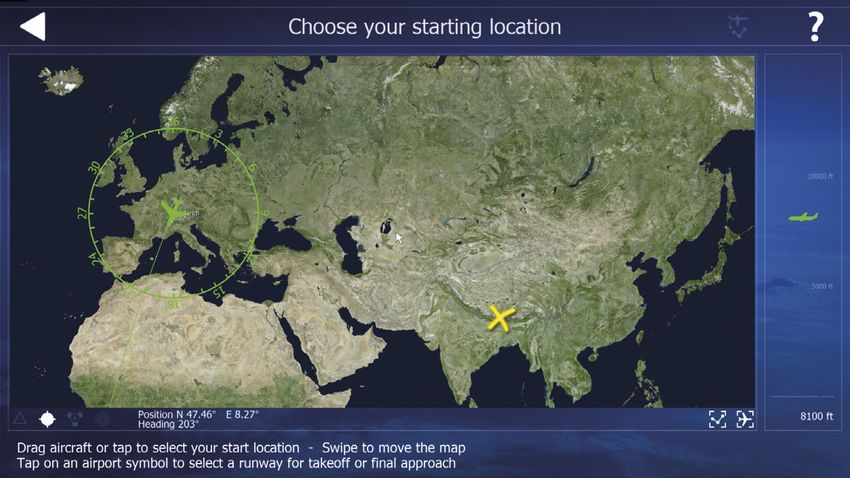
Lukla – Mount Everest – Extreme

   Approach and takeoff:                                                        Communication and          •   Do not turn on engines before ensuring
                                                                                Clearance                      with security personnel that no passengers
    Takeoff RWY            24 only                                                                             are near engines.
    Landing RWY            06 only                                                                         •   Do not start taxiing while still transmitting
    Approach               Aircraft must establish its approach on right                                       flight details unless approved.
                           base at 9700 ft.                                                                •   Approval from Lukla AFIS is required for
                                                                                                               taxi, line-up and takeoff.
    Go-around procedure:   •   Go-around below 9300ft is not possible
                               due to the narrow valley surrounded by                                      •   VHF communications need to be monitored
                               high mountains.                                                                 by both pilots for other helictoper and
                                                                                                               aircraft movement in the area. After leaving
                           •   Go around no later than before crossing
                                                                                                               Lukla area, pilots should continue monitor-
                               Dudkoshi River. Not below 9300ft with an
                                                                                                               ing VHF frequencies of Lukla and Kathman-
                               immediate left turn climb.
                                                                                                               du for aircraft movement around Phaplu,
                           •   Continue turning left until established on                                      Lamjura and Jiri areas.
                               finals for RWY 06 again. Beware of high
                               mountains to the west during the turn.           Caution:                   •   Downtrafts on approach may force pilot to
                                                                                                               increase speed to gain back altitude, which
    Safety advisories:     •   Typical wind conditions:                                                        may cause a hard landing.
                               General: From south-west and south-east
                                                                                                           •   Due to the steep uphill gradient of runway
                               direction.
                                                                                                               aircraft should be landed by a slight amount
                               In early morning: From north-east/west
                                                                                                               of power on.
                               direction
                               After 10:00: From south-east/west direction      Escape Route Procedures:   •   “Aviate, Navigate, Communicate”!
                               Downdrafts/updrafts are likely if tailwind is                               •   Follow Dudhkoshi River south down to
                               above 7-8 kts.                                                                  Lamidanda.
                           •   Beware of optical illusions because of the                                  •   Inform ATC and cabin crew.
                               strong slope of the runway. Always keep
                                                                                                           •   Past Lamidanda, continue to Sunkoshi river.
                               enough engine power.
                                                                                                               Follow Sunkoshi river east for Biratnagar
                           •   It is not recommended to fly if wind varies                                     and west for Kathmandu.
                               or is stronger than 8 kts.
                                                                                                           •   Stay above river for better ground clearance
                           •   When approaching with STOL airspeeds on                                         and visual navigation.
                               short final, do not move above or below
                                                                                                           •   Do not fly over passes and ridges.
                               glidepath unless wind conditions are calm.
                           •   Do not turn off engines while approaching.       Limitations:               Visibility: Minimum 5000 m
                           •   Only set full flaps when runway is in sight                                 Cloud ceiling: Minimum 1500 ft
                               and final decision for landing has been                                     Tailwind: Maximum 10 kts
                               made.                                                                       Crosswind: Maximum 15 kts
                           •   Beware of sun glare in early morning which                                  VFR ONLY!
                               may make it difficult to see the runway
                               properly in haze.                               Source of some information: http://www.caanepal.gov.np/wp-content/
                                                                               uploads/2016/03/TENZING-HILLARY-AIRPORT.pdf
                                  16                                                                                  17
Aerosoft GmbH 2019
Lukla – Mount Everest – Extreme

   VNSB Syangboche
   Although build just a few years after Lukla, and being closer to Mount
   Everest, Syangboche never really went into full operation like its
   companion further down the valley. It is located even higher than Lukla,
   making it a difficult destination for acclimatization to the thin air.
   In addition to that local people from the villages below opposed to
   the opening of another airport higher up because it would threaten
   their businesses, cutting them off from the tourist stream hiking to
   Mount Everest.
   For a while the airport was approached by Pilatus Porters, which
   seems to be one of the very few aircraft recommended to be used at
   this airport. Nowadays there are mostly occasional helicopter charter
   flights and cargo flights using the unpaved airstrip that is located
   right on the trail to Mount Everest.
   It is a popular destination for so called “Everest Skydives” that are
   done with helicopters ascending from here and dropping the
   skydivers high above the airstrip (fantastic views to Mount Everest in
   the distance included).

                                                                              VNSB Syangboche – General Information:

                                                                              Name                 Syangboche
                                                                              ICAO code            VNSB
                                                                              IATA code            SYH
                                                                              Coordinates          N 27.48.3 E 86.42.4
                                                                              Elevation            3754.28 m / 12317 ft
                                                                              Operational          No
                                                                              Operation hours      Nov - Jan: 10:00-16:00 local time
                                                                                                   Feb - Oct: 10:00-17:00 local time

                                   18                                                                        19
Aerosoft GmbH 2019
Lukla – Mount Everest – Extreme
Start of operations: ca. 1970 VNPL Phaplu
Servicability: Seasonal Phaplu is the closest airport to Mount Everest that is connected to the
Fuel - not available - national road network. Due to rising tourist numbers there are more
and more scheduled flights to this airport which is not only a gateway
Rescue and fire fighting - not available -
services to Everest but a beautiful destination in itself.
Navigation - not available - The airport has an interesting location along a slope with the apron
carved into the terrain and the tower and terminal on top of a high
Coms - not available -
wall that follows the runway. Be cautious when taxiing here as you
Metereological info - not available - wouldn’t be the first whose wingtip would touch the wall!
Services - not available -
Approaches to the airport however are troubled by the harsh wind
Ground transportation - not available - conditions in the valley. Due to strong wind the airport closes at noon,
Type of aircraft C208 which means that flights are only happening in the morning hours
when the weather is usually suitable for flying. Gusts of 43 knots
have been recorded here.
Runway: Flights that cannot land in Lukla due to bad weather are often
rerouted to Phaplu (provided the weather conditions here are suitable
Type of surface Clay/Grass
for flying).
Runway dimensions 405 x 30 meters
5.63% upslope from rwy 31
Runway designation 13/31
Apron No designated apron.
Parking capacity for 2 small aircraft.
PAPI - not available -
Approach and takeoff:
Takeoff RWY 13 only
Landing RWY 31 only
Source of some information: http://www.caanepal.gov.np/wp-content/
uploads/2016/03/SYANGBOCHE-AIRPORT.pdf
20 21
Aerosoft GmbH 2019Lukla – Mount Everest – Extreme
Start of operations: 1976
Servicability: All weather
Fuel - not available -
Rescue and fire fighting - not available -
services
Navigation - not available -
Coms HF SSB: 5805.5 (not applicable for Aerofly FS2)
VHF: 122.5 (not applicable for Aerofly FS2)
Metereological info Yes (tower observation)
Services AFIS
VFR
Ground transportation Jeep, tractor, van
Type of aircraft D228, DHC6, L410, Y12, C208
Runway:
Type of surface Bitumen
Runway dimensions 680 x 20 meters
2.4% upslope from rwy 20
VNPL Phaplu – General Information: Runway designation 20/02
Name Phaplu Apron 1 bitumen apron east of rwy
ICAO code VNPL 1 unsealed area west of rwy with additional
parking and cargo capacity
IATA code PPL
PAPI - not available -
Coordinates N27.30.5 E86.35.1
Elevation 2461.074 m / 8074 ft
Operational Yes Approach and takeoff:
Operation hours Jan, Feb, Nov, Dec: 06:45-12:30 local time Takeoff RWY Both
Mar, Apr, Sep, Oct: 06:15-12:30 local time Landing RWY 20 only
May, Jun, Jul, Aug: 06:00-12:00 local time
22 23
Aerosoft GmbH 2019Lukla – Mount Everest – Extreme
Suggested approach Turn from downwind, bank 30° at 500ft decend VNRT Rumjatar
rate to establish slideslope towards RWY 20.
RWY 20 The airport of Rumjatar is located on top of a plateau at an immensely
Takeoff When taking off from 02, bank left immediately beautiful subtropical location.
with minimum bank 30° Due to the fact that there are only few tourists flying here and many
Safety advisories: Turbulence on base and final turns to be locals prefer longer but cheaper road transport options, the airport is
expected in windy conditions. sometimes without any scheduled connections.
Left hand circuit recommended.
Flight operations not recommended in changing
wind conditions of more than 8 kts.
Wind usually from southwest, usually getting
very strong after 10:00.
Source of some information: http://www.caanepal.gov.np/wp-content/
uploads/2016/03/PHAPLU-AIRPORT.pdf
VNRT Rumjatar – General Information:
Name Rumjatar
ICAO code VNRT
24 25
Aerosoft GmbH 2019Lukla – Mount Everest – Extreme
IATA code RUM VNKL Kangel Danda
Coordinates N 27.18.1 E 86.33.0 Kangel Danda is spectacularly located on top of a mountain between
Elevation 1373.062 m / 419 ft Rumjatar and Lukla. At both ends of the runway there are steep cliffs
letting you gain ground clearance quickly without even climbing.
Operational Yes
Operation hours Nov - Jan: 10:00-16:00 local time Unfortunately there are no scheduled flights here any more since the
coms equipment got destroyed by a thunderstorm and there are no
Feb - Oct: 10:00-17:00 local time efforts being made to repair it. The goats grazing the airport are
Start of operations: 1972 happy using it as a welcome pasture land.
Servicability: All weather
Fuel - not available -
Rescue and fire fighting - not available -
services
Navigation - not available -
Coms HF SSB: unknown
VHF: 122.3 (not applicable for Aerofly FS2)
Metereological info Yes (tower observation)
Services AFIS
VFR
Ground transportation - unknown -
Type of aircraft D228, DHC6, L410, Y12, C208
Runway:
Type of surface Bitumen
Runway dimensions 548 x 30 meters
4.33% upslope from rwy 35
Runway designation 17/35
Apron 1 bitumen apron west of rwy.
Parking capacity for 3 small aircraft.
PAPI - not available -
Source of some information: http://www.caanepal.gov.np/wp-content/
uploads/2016/03/RUMJATAR-AIRPORT.pdf
26 27
Aerosoft GmbH 2019Lukla – Mount Everest – Extreme
VNKL Kangel Danda – General Information: Apron Clay/grass apron north of rwy.
Name Kangel Danda Parking capacity for 2 small aircraft.
ICAO code VNKL PAPI - not available -
IATA code KGL Source of some information: http://www.caanepal.gov.np/wp-content/
uploads/2016/03/KANGELDANDA-AIRPORT.pdf
Coordinates N 27.25.0 E 86.38.1
Elevation 2005.474 m / 6580 ft
Operational No VNBJ Bhojpur
Operation hours Jan, Feb, Nov, Dec: 06:45-12:30 local time An airport serving the local mountain villages with scheduled
passenger flights.
Mar, Apr, Sep, Oct: 06:15-12:30 local time
The runway has been paved in 2017.
May, Jun, Jul, Aug: 06:00-12:30 local time
Start of operations: 2003
Servicability: Seasonal
Fuel - not available -
Rescue and fire fighting - not available -
services
Navigation - not available -
Coms HF SSB: unknown
VHF: 122.5 (not applicable for Aerofly FS2)
Metereological info - not available -
Services - not available -
Ground transportation - unknown -
Type of aircraft L410, DHC6, Y12, C208
Runway:
Type of surface Clay/Grass
Runway dimensions 520 x 26 meters
1.4% upslope from both ends towards center
Runway designation 29/11
28 29
Aerosoft GmbH 2019Lukla – Mount Everest – Extreme
VNBJ Bhojpur – General Information: Apron 1 bitumen apron east of rwy.
Name Bhojpur Parking for 3 small aircraft.
ICAO code VNBJ PAPI - not available -
IATA code BHP Source of some information: http://www.caanepal.gov.np/wp-content/
Coordinates N 27.08.5 E 87.03.0 uploads/2016/03/BHOJPUR-AIRPORT.pdf
Elevation 1214.117 m / 3983 ft
Operational Yes VNJI Jiri
Operation hours Jan, Feb, Nov, Dec: 06:45-12:30 local time Despite being a famous tourist destination, Jiri hasn’t seen scheduled
Mar, Apr, Sep, Oct: 06:15-12:30 local time air traffic in many years. The airstrip seems to have been abandoned
and it is unknown if it can still be used for takeoffs and landings. For
May, Jun, Jul, Aug: 06:00-12:30 local time years there are plans to bring the airport back to life.
Start of operations: 1978
Servicability: All weather
Fuel - not available -
Rescue and fire fighting - not available -
services
Navigation - not available -
Coms HF SSB: unknown
VHF: 122.3 (not applicable for Aerofly FS2)
Metereological info Yes (tower observation)
Services AFIS
VFR
Ground transportation - unknown -
Type of aircraft L410, DHC6, Y12, C208
Runway:
Type of surface Bitumen
Runway dimensions 545 x 20 meters
7.2% upslope from rwy 35
Runway designation 17/35
30 31
Aerosoft GmbH 2019Lukla – Mount Everest – Extreme
VNJI Jiri – General Information: VNLD Lamidanda
Name Jiri An airport serving the local mountain villages.
ICAO code VNJI The runway has been paved in 2018/19.
IATA code JIR
Coordinates N 27.37.35 E 86.13.50
Elevation 1854 m / 6083 ft
Operational No
Operation hours Nov - Jan: 10:00-16:00 local time
Feb - Oct: 10:00-17:00 local time
Start of operations: 1976
Servicability: Seasonal
Fuel - not available -
Rescue and fire fighting - not available -
services
Navigation - not available -
Coms - not available -
Metereological info - not available -
Services - not available -
Ground transportation - unknown -
Type of aircraft DHC6, Y12, C208
Runway:
Type of surface Clay/Grass
Runway dimensions 368 x 18 meters
2.25% upslope from rwy 32 VNLD Lamidanda – General Information:
Runway designation 14/32
Name Lamidanda
Apron No designated apron.
ICAO code VNLD
Parking capacity for 3 small aircraft.
IATA code LDN
PAPI - not available -
Coordinates N 27.15.1 E 86.40.1
Source of some information: http://www.caanepal.gov.np/wp-content/
Elevation 1232 m / 4042 ft
uploads/2016/03/JIRI-AIRPORT.pdf
32 33
Aerosoft GmbH 2019Lukla – Mount Everest – Extreme
Operational Yes VNKD Man Maya Khanidanda
Operation hours Nov - Jan: 10:00-16:00 local time An airport serving the local mountain villages.
Feb - Oct: 10:00-17:00 local time The runway has been paved in 2016. Due to quality issues severe
Start of operations: 1972 erosion problems have been reported.
Servicability: All weather
Fuel - not available -
Rescue and fire fighting - not available -
services
Navigation - not available -
Coms HF SSB: unknown
VHF: 122.5 (not applicable for Aerofly FS2)
Metereological info Yes (tower observation)
Services AFIS
VFR
Ground transportation - unknown -
Type of aircraft DHC6, L410, Y12, C208
Runway:
Type of surface Bitumen
Runway dimensions 516 x 30 meters
1.93% upslope from rwy 26
Runway designation 26/08
Apron 1 bitumen apron north of rwy.
Parking capacity for 3 small aircraft.
PAPI - not available - VNKD Man Maya Khanidanda – General Information:
Source of some information: http://www.caanepal.gov.np/wp-content/ Name Man Maya Khanidanda
uploads/2016/03/LAMIDANDA-AIRPORT.pdf
ICAO code VNKD
IATA code KDN
Coordinates N 27.10.5 E 86.46.1
34 35
Aerosoft GmbH 2019Lukla – Mount Everest – Extreme
Elevation 1348 m / 4423 ft VNRC Ramechhap
Operational Yes An airport serving the local towns and villages.
Operation hours Jan, Feb, Nov, Dec: 06:45-12:30 local time The runway was paved in 2017.
Mar, Apr, Sep, Oct: 06:15-12:30 local time
At “only” 1627ft it is the airport with the lowest elevation in this
May, Jun, Jul, Aug: 06:00-12:30 local time scenery package.
Start of operations: 2006
Servicability: All weather
Fuel - not available -
Rescue and fire fighting - not available -
services
Navigation - not available -
Coms HF SSB: unknown
VHF: 122.5 (not applicable for Aerofly FS2)
Metereological info Yes (tower observation)
Services AFIS
VFR
Ground transportation - unknown -
Type of aircraft L410, DHC6, Y12, C208
Runway:
Type of surface Bitumen
Runway dimensions 590 x 20 meters
5.01% upslope from rwy 08
Runway designation 26/08
Apron 1 bitumen apron north of rwy.
Parking for 3 small aircraft. VNRC Ramechhap – General Information:
PAPI - not available -
Name Ramechhap
Source of some information: http://www.caanepal.gov.np/wp-content/
ICAO code VNRC
uploads/2016/03/KHANIDANDA-AIRPORT.pdf
IATA code RCH
36 37
Aerosoft GmbH 2019Lukla – Mount Everest – Extreme
Coordinates N 27.23.3 E 86.03.4 VNTJ Taplejung (Suketar)
Elevation 496 m / 1627 ft An airport serving the local mountain villages with scheduled
Operational Yes passenger flights. The runway has been paved in 2016.
Operation hours Jan, Feb, Nov, Dec: 06:45-12:30 local time It is by far the easternmost airport in this package. To the east one
Mar, Apr, Sep, Oct: 06:15-12:30 local time can see Mount Kanchenjunga on the border to India, which is the
word’s 3rd highest mountain.
May, Jun, Jul, Aug: 06:00-12:30 local time
Start of operations: 1979
Servicability: All weather
Fuel yes
Rescue and fire fighting - not available -
services
Navigation - not available -
Coms HF SSB: unknown
VHF: 122.5 (not applicable for Aerofly FS2)
Metereological info Yes (tower observation)
Services AFIS
VFR
Ground transportation Jeep, Van
Type of aircraft D228, DHC6, L410, Y12, C208
Runway:
Type of surface Bitumen
Runway dimensions 530 x 20 meters
slightly sloped
Runway designation 21/03
Apron 1 bitumen apron east of rwy. VNTJ Taplejung – General Information:
Parking capacity for 3 small aircraft. Name Taplejung (Suketar)
PAPI - not available - ICAO code VNTJ
Source of some information: http://www.caanepal.gov.np/wp-content/ IATA code TPJ
uploads/2016/03/RAMECHHAP-AIRPORT.pdf
38 39
Aerosoft GmbH 2019Lukla – Mount Everest – Extreme
Coordinates N 27.21.0 E 87.41.4 VNTR Tumlingtar
Elevation 2426 m / 7959 ft An airport serving the local mountain villages with scheduled
Operational Yes passenger flights. It is the largest and only Nepalese airport in this
package that doesn’t require aircraft with STOL capabilities.
Operation hours Jan, Feb, Nov, Dec: 06:45-12:30 local time
Mar, Apr, Sep, Oct: 06:15-12:30 local time
May, Jun, Jul, Aug: 06:00-12:30 local time
Start of operations: 1976
Servicability: Seasonal
Fuel - not available -
Rescue and fire fighting - not available -
services
Navigation - not available -
Coms HF SSB: unknown
VHF: 122.5 (not applicable for Aerofly FS2)
Metereological info Yes (tower observation)
Services AFIS
VFR
Ground transportation - unknown -
Type of aircraft D228, DHC6, L410, Y12, C208
Runway:
Type of surface Bitumen
Runway dimensions 700 x 20 meters
3.98% upslope from rwy 07
Runway designation 25/07
VNTR Tumlingtar – General Information:
Apron 1 bitumen apron north of rwy. Name Tumlingtar
Parking capacity for 3 small aircraft. ICAO code VNTR
PAPI - not available - IATA code TMI
Source of some information: http://www.caanepal.gov.np/wp-content/ Coordinates N 27.19.0 E 87.11.4
uploads/2016/03/TAPLEJUNG-AIRPORT.pdf
40 41
Aerosoft GmbH 2019Lukla – Mount Everest – Extreme
Elevation 399.5 m / 1311 ft ZUTG Tingri
Operational Yes
Operation hours Nov - Jan: 10:00-16:00 local time
Feb - Oct: 10:00-17:00 local time
Start of operations: 1972
Servicability: All weather
Fuel - not available -
Rescue and fire fighting - not available -
services
Navigation - not available -
Coms HF SSB: unknown
VHF: 123.95 (not applicable for Aerofly FS2)
Metereological info Yes (tower observation)
Just recently the People’s Republic of China has announced to build 3
Services AFIS more airports in the Autonomous Province of Tibet. One of them is
VFR the airport of Tingri (or Dingri) estimated to be build just about 60
kilometers north of Mount Everest.
Ground transportation Jeep, Van
Type of aircraft JS41, B190, D228, L410, DHC6, Y12, C208 This airport will likely be a deal changer for tourism in the region. It’s
immense runway will allow airliners to land rather close to Mount
Runway: Everest. A road from here leads to the Chinese/Tibetan Mount Everest
Base Camp.
Type of surface Bitumen
Some combined information:
Runway dimensions 1220 x 30 meters
• It’s just about 65 kilometers north of Mount Everest (Chinese/
0.91% upslope from rwy 34
Tibetan Mount Everest base camp is accessible by road from
Runway designation 16/34 there).
Apron 1 bitumen apron east of rwy. • At a whopping altitude of 4320 meters / 14100 ft, it will
Parking for 3 small aircraft. probably be at the top 3 of world’s highest airports. Great for
PAPI no bringing larger jets to their limits - you will need quite a bit of
that long runway for takeoff.
Source of some information: http://www.caanepal.gov.np/wp-content/
uploads/2016/03/TUMLINGTAR-AIRPORT.pdf • It will be the first and only airport in the area supporting larger
jets - great for heavy iron sightseeing flights to Mt Everest!
Most aircraft capable to land in Lukla will not be able to get
up to that altitude!
42 43
Aerosoft GmbH 2019Lukla – Mount Everest – Extreme
•
•
Runway of 4500 x 45 meters with parallel taxiway.
Note that the exact location, layout and technical details of
Technical Advice
the airport are only approximate until construction is finished.
For more information about high altitude operations, check out the Flight Routes To Lukla
following operations manual available for Aerosoft’s Airbus add-ons:
For real world flight routes to Lukla, check out the KMZ file for
https://forum.aerosoft.com/index.php?/topic/140129-hight-altitude-
Google Earth™ that comes with this scenery. You will find it as an
airport-operations-on-airport-with-an-elevation-of-9200ft-or-above/
entry in your Windows Start menu.
After opening the KMZ file, activate the display of flight routes in the
file’s subfolders in Google Earth™ (flight routes are not visible by
default).
You can right click those waypoints on the map. Then click properties.
After that you can note the individual waypoints names and their
coordinates to be put into a FMC / GPS / flight planner if you use one.
44 45
Aerosoft GmbH 2019Lukla – Mount Everest – Extreme
3rd Party Add-on Sceneries Folder Structure
Because we are often asked what files do exactly what, we decided to
Kathmandu document the files in some detail. Please note that we only advice
experienced users to use this information and we do not support any
This product focuses on the immediate Mount Everest region, which editing of these files.
is still a large 200x200 km area. Kathmandu, the main airport for
flights to and from Lukla, is not included in Aerofly FS2. Base folder will most likely be your:
You can however download a freeware package for the airport that My Documents\Aerofly FS 2\addons\scenery\
will add a few objects and the airport’s ground layout: • aerosoft_lukla
http://www.fscloudport.com/icao/VNKT.htm • elevation
As this package doesn’t touch the scenery borders of “Lukla – Mount Detailed elevation data. This does not include runway
Everest - Extreme”, it will be compatible. Same applies for all other slopes and immediate airport vicinities (those are stored in
sceneries that are not within coverage range. the individual airport folders).
• images
Incompatible Sceneries Base aerial/satellite imagery
Please note that all other airports published on FSCloudport, that are • places
within the “Lukla – Mount Everest - Extreme” coverage area (see • helipads
maps) are not compatible. Please remove their filesets to avoid Start location/3D data for all helipads
duplicates (in case you installed them previously). Those airports
include: • lukla_landscape
VFR scenery 3D models/terrain/placement
http://www.fscloudport.com/icao/VNJI.htm Cultivation files (trees and buildings)
http://www.fscloudport.com/icao/VNSB.htm • _
http://www.fscloudport.com/icao/VNLK.htm Individual airport/3D/Terrain data and start locations for
all airports
http://www.fscloudport.com/icao/VNRT.htm
http://www.fscloudport.com/icao/VNPL.htm
http://www.fscloudport.com/icao/VNBJ.htm
http://www.fscloudport.com/icao/VNTR.htm
http://www.fscloudport.com/icao/VNTJ.htm
46 47
Aerosoft GmbH 2019Lukla – Mount Everest – Extreme
Known Issues (FAQ) Q: When selecting approach positions at certain airports, I do
find myself crashing into a ridge!
Q: Why are there long shadows caused by some buildings and A: It is currently not possible to move or remove certain approach
rocks in low sunlight? positions of runways in Aerofly FS2 as those are created automatically
A: This is normal as shadows get “longer”, the lower the sun is. What by the simulator without regards to the surrounding terrain. It is
makes those shadows standing out so much in a mountainous terrain advised to use this feature with caution and to select approach
like here is that Aerofly FS2’s graphics engine does not support terrain positions only for runways that are described as suitable for landing in
shadows yet. the airports chapter of this manual. If only one runway direction is
described as suitable for landing you can almost be sure that the
In other words: While objects throw shadows, those big mountains other one will have a ridge in between you and the airport along a
don’t. No matter how low the sun is at the sky. This makes those straight approach path.
individual shadows stand out pretty much as long as you keep them
active in your settings (which we personally prefer on our own Q: Some cultivation buildings are partially hovering and
systems because other than that they just look great in Aerofly FS2). sunken into the terrain!
Same applies for grass which does not display shadows in the current A: Similarly to autogen buildings in FSX/P3D, cultivation buildings are
simulator engine. placed at random reference points around their footprint. In steep
terrain like the Himalayas this can cause some parts of some buildings
Q: The airport information mentions com frequencies. How to to hover above the ground or disappear into terrain slopes. This is
use those? why we converted many buildings nearby airports and some helipads
A: Com frequencies are not yet supported in Aerofly FS2. into actual 3D models instead of lower detail cultivation objects.
While looking nicer of course, those are more difficult in regards to
Q: Why do the wind turbines and windsocks do not head into performance and development efforts.
the wind?
A: Currently this is not supported by Aerofly FS2.
Q: The Robinson R-22 (default aircraft in Aerofly FS2) won’t
take off from my chosen location!
A: The Robinson R-22 is not suitable for high locations with thin air.
You will have difficulties to fly it in and out Lukla and flying it from
locations higher up than Namche Bazaar is simply impossible. You
may be able to gain some ground clearance in Namche Bazaar but
you carefully need to push the nose down to gain some forward
speed and and a low climb rate.
Q: Why is there never snow / winter in Lukla?
A: Being close to the equator there is barely any seasonal change in
the region in terms of snow cover. That’s why we didn’t invest time
into seasonal textures but a larger scenery coverage area instead.
48 49
Aerosoft GmbH 2019Lukla – Mount Everest – Extreme
Credits Copyrights
Concept: Sascha Normann Die Software, das Handbuch und sonstiges zugehöriges Material sind
GIS: Sascha Normann durch Urheberrechtsgesetze geschützt. Die Software wird lizenziert,
nicht verkauft. Sie dürfen eine Kopie der Software auf einem Com-
Modeling/texturing: Sascha Normann
puter für Ihre persönliche, nichtkommerzielle Nutzung installieren und
Project Management: Sascha Normann ausführen. Die Software, das Handbuch und alle anderen zuge-
Manual, documentation: Sascha Normann hörigen Materialien dürfen ohne vorherige schriftliche Erlaubnis der
Entwickler der Software und der Aerosoft GmbH weder kopiert,
Core area base satellite imagery: Cartosat-1 ISRO/Antrix
fotokopiert, übersetzt, zurückentwickelt, dekompiliert, disassembliert
10m/pix satellite imagery outside core coverage area and color oder in anderer Form für elektronische Maschinen lesbar gemacht
information for core imagery: Copernicus Sentinel data 2018 werden.
Mount Everest area imagery: Sofian Moumene - Everest Mountain Aerosoft GmbH
Range
Lindberghring 12
(https://www.turbosquid.com/3d-models/range-everest-3d-1173462)
D-33142 Büren, Germany
Phaplu and Rumjatar airport satellite imagery:
www.aerosoft.com
Rumjatar, 2017 © 21AT, Supplied by Earth-i Ltd. All Rights Reserved.
Phaplu, 2017 © 21AT, Supplied by Earth-i Ltd. All Rights Reserved.
Elevation data + manual edits: NASA Jet Propulsion Laboratory (JPL),
2014, NASA Shuttle Radar Topography Mission Global 1 arc second.
Version 3. 26°N, 84°E to 28°N, 88°E NASA EOSDIS Land Processes
DAAC, USGS Earth Resources Observation and Science (EROS) Center,
Sioux Falls, South Dakota (https://lpdaac.usgs.gov), accessed January
4, 2018, at https://earthexplorer.usgs.gov/
Special thanks to Nishan Manandhar for providing detailed photos of
Lukla and Phaplu airports as well as additional input, Lindsay Eaton
for providing great aerial imagery of Phaplu airport.
Arno Gerretsen for his never ending dedication to the FS developer
community, particularly for his great tool “scenproc” that helped
adding millions and millions of objects to this scenery!
Martin Pahnev for some Lukla airport base models.
All betatesters involved who never give up reporting bugs until a
product is perfect and ready for release!
50 51
Aerosoft GmbH 2019Lukla – Mount Everest – Extreme
ADD-ONS FOR
52
Aerosoft GmbH 2019 www.aerosoft.comYou can also read