Kent Mineral Sites Plan 2019-30 - Collated Transport Assessment of Mineral Option Sites - Kent County Council
←
→
Page content transcription
If your browser does not render page correctly, please read the page content below
Kent Mineral Sites Plan 2019-30
Collated Transport Assessment of Mineral
Option Sites

April 2019

Collated Transport Assessments of the Mineral Sites, April 2019
Page 1 of 35
Table of Contents
1.0 Introduction................................................................................................................................... 3
2.0 National Planning Policy and Guidance ................................................................................ 4
   2.1 Promoting Sustainable Transport ....................................................................................... 4
   2.2 Planning Practice Guidance ................................................................................................. 4
3.0 Context ........................................................................................................................................... 5
4.0 Methodology ................................................................................................................................. 6
   4.1 Initial Screening ....................................................................................................................... 6
   4.2 Detailed Technical Assessment .......................................................................................... 8
5.0 Results and conclusions ........................................................................................................... 9
   5.1 Site: M3 Chapel Farm (West) - Folkestone Beds Soft Sand ......................................... 9
   5.2 M8: West Malling Sandpit, Ryarsh- Folkestone Beds Soft Sand .............................. 13
   5.3 M2: Lydd Quarry/Allen’s Bank Extension, Lydd-Storm Beach Deposits ............... 17
   5.4 M7: Land at Central Road, Dartford .................................................................................. 20
   5.6 M11: Joyce Green Farm Quarry Extension, Dartford - Sharp Sand and Gravel ... 23
   5.7 M9 The Postern, Capel - Sharp Sand and Gravels ....................................................... 26
   5.8 M10: Moat Farm, Five Oak Green, Capel ......................................................................... 26
   5.9 M12: Postern Meadows, Tonbridge .................................................................................. 28
   5.10 M13: Stonecastle Farm Quarry Extensions, Hadlow/Whested................................ 30
6.0 Summary...................................................................................................................................... 33
Appendix 1: Results of the initial RAG scoring of all promoted sites that align with the
Kent Minerals and Waste Local Plan 2013-30 with regard to transport impacts ............ 34

Collated Transport Assessments of the Mineral Sites, April 2019
Page 2 of 35

1.0 Introduction
1.1   The Proposed Submission Kent Minerals Sites Plan identifies three sites considered
      suitable for development as mineral quarries. The sites that are considered suitable are
      those shown not to have any overriding obstacles to their development, in terms of the
      acceptability of impacts on communities and the environment.

1.2   To assist the independent examination of the Kent Minerals Sites Plan, this document
      collates the information that was used to assess the likely transportation impacts of sites
      and the conclusions reached regarding their suitability.

1.3   In reaching conclusions on the suitability of a site, a judgement was made as to whether
      development at the site would be able to come forward that would be consistent with
      policies in the adopted Kent Minerals and Waste Local Plan intended to ensure that
      unacceptable transportation impacts do not arise. The key policy is Policy DM 13:
      Transportation of Minerals and Waste which states the following:

      “Minerals and waste development will be required to demonstrate that emissions
      associated with road transport movements are minimised as far as practicable and
      by preference being given to non-road modes of transport. Where development
      requires road transport, proposals will be required to demonstrate that:

       1. the proposed access arrangements are safe and appropriate to the scale and
          nature of movements associated with the proposed development such that the
          impact of traffic generated is not detrimental to road safety
       2. the highway network is able to accommodate the traffic flows that would be
          generated, as demonstrated through a transport assessment, and the impact of
          traffic generated does not have an unacceptable adverse impact on
          theenvironment or local community.
       3. emission control and reduction measures, such as deployment of low emission
          vehicles and vehicle scheduling to avoid movements in peak hours. Particular
          emphasis will be given to such measures where development is proposed within
          an AQMA. (Figure 15)”

1.4   The adopted Kent Minerals and Waste Local Plan 2013-30 was evidentially supported,
      as a strategic document for waste and mineral developments across Kent by a Strategic
      Transport Assessment1 prepared in September 2013. The document itself was
      predicated upon the evidence prepared for the Kent Local Transport Plan (2011-2016)
      and Kent Freight Action Plan (2012-2016). The Kent Local Transport Plan (2011-2016)
      has now been superseded by the Kent Local Transport Plan (2016-2031) adopted in
      2016. “These Plans note that it is important to consider congestion and associated air
      quality impacts (both on communities and the environment) when assessing the
      suitability of proposals that involve HGV movements. With climate change being of
      particular importance in terms of the wider environmental impact.

1.5   In order to reflect this approach in the Kent Minerals and Waste Local Plan 2013-30,
      specific policy was formulated to (Policy DM 13: Transportation of Minerals and Waste)
      as stated above. The policy requires that minerals and waste developments demonstrate
      that emissions associated from road transportation are minimised as far as practical,
      with preference given to non-road modes of transportation. Where road transportation is

1
  See document KCC/MWLP/CS/013 in the Kent Minerals and Waste Local Plan 2013-30 examination document
library at the following link http://consult.kent.gov.uk/portal/mwcs/mwlp-eip/eip-library/

Collated Transport Assessments of the Mineral Sites, April 2019
Page 3 of 35
required (for example, where geological distribution of mineral resources leaves no other
         realistic transportation option) proposals will have to address criteria 1 to 3 in policy
         DM13.

1.6      This report shows how the adopted policy criteria have been applied to the assessment
         of Minerals Option Sites and informed the conclusions concerning the suitability of the
         sites included in the Pre-Submission Kent Mineral Sites Plan.

2.0 National Planning Policy and Guidance
2.1 Promoting Sustainable Transport
2.1.1 The National Planning Policy Framework (2019)2 expects that “Transport issues should
      be considered from the earliest stages of plan-making and development proposals, so
      that:

         a) the potential impacts of development on transport networks can be addressed;
         b) opportunities from existing or proposed transport infrastructure, and changing
         transport technology and usage, are realised – for example in relation to the scale,
         location or density of development that can be accommodated;
         c) opportunities to promote walking, cycling and public transport use are identified and
         pursued;
         d) the environmental impacts of traffic and transport infrastructure can be identified,
         assessed and taken into account – including appropriate opportunities for avoiding and
         mitigating any adverse effects, and for net environmental gains; and
         e) patterns of movement, streets, parking and other transport considerations are integral
         to the design of schemes, and contribute to making high quality places.”

2.1.2 Mineral development has the potential to impact transportation in a significant manner.
      The distribution of minerals is significantly achieved by the use of heavy goods vehicles
      (HGVs) as often the opportunities for other modes of transport are unavailable or would
      be unrealistically expensive and impracticable. This is by fact of the geological
      distribution of resources not necessarily coinciding with rail or water borne transportation
      opportunities. Therefore, in assessing mineral development allocations and their
      transportation impacts the County Council consulted the respective local authorities and
      the County Highway Authority accordingly to gather the necessary information to
      determine the transport implications of the promoted Option sites at the plan making
      stage and inform the choice of allocations. This process was significantly driven by the
      need to balance the maintenance of a steady and adequate supply of aggregates with
      the need for development to not add to congestion and emissions, that can adversely
      affect air quality and public health.

2.2 Planning Practice Guidance

2.2.1 The government has issued guidance on the key issues that should be considered
      when developing a transport evidence base in support of a local plan. Issued in 2014
      Paragraph: 003 Reference ID: 54-003-201410103 states:

2
    Para 102
3
    https://www.gov.uk/guidance/transport-evidence-bases-in-plan-making-and-decision-taking

Collated Transport Assessments of the Mineral Sites, April 2019
Page 4 of 35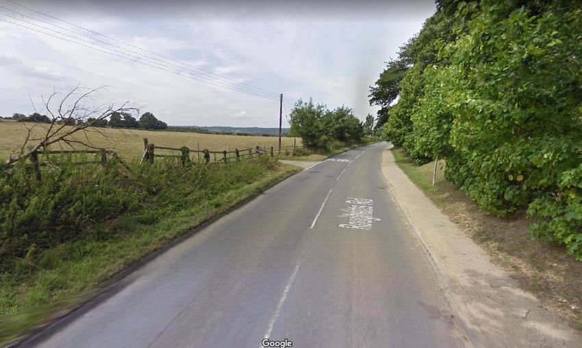
“The key issues, which should be considered in developing a transport evidence base,
      include the need to:
      • assess the existing situation and likely generation of trips over time by all modes
         and the impact on the locality in economic, social and environmental terms
      • assess the opportunities to support a pattern of development that, where
         reasonable to do so, facilitates the use of sustainable modes of transport
      • highlight and promote opportunities to reduce the need for travel where appropriate
      • identify opportunities to prioritise the use of alternative modes in both existing and
         new development locations if appropriate
      • consider the cumulative impacts of existing and proposed development on transport
         networks
      • assess the quality and capacity of transport infrastructure and its ability to meet
         forecast demands
      • identify the short, medium and long-term transport proposals across all modes

      The outcome could include assessing where alternative allocations or mitigation
      measures would improve the sustainability, viability and deliverability of proposed land
      allocations (including individual sites) provided these are compliant with national policy
      as a whole.”

2.2.2 When identifying the sustainable allocations for maintaining a steady and adequate
      supply of aggregate minerals, preparation of the Kent Minerals Sites Plan considered
      the transport implications of all the identified Option sites against the specific highway
      and transportation criteria above, that are relevant, and the adopted Kent Minerals and
      Waste Local Plan 2013-30 Policy DM 13, to the site in question. This work identified that
      the sites are deliverable and in accordance with the National Planning Policy Framework
      on promoting sustainable transport and the adopted local plan policy to minimise
      transport related emissions, while recognising the specific and unique characteristic of
      mineral development in that it is significantly affected by the geological distribution of
      finite mineral resources.4

3.0 Context
3.1   Kent has extensive transportation links by road, rail and water with northern France,
      London, Essex and the South East of England (see Figure 1). The County Council has
      a statutory duty to prepare and update its Strategic Transport Plan, the Local Transport
      Plan for Kent 2016-2031, as adopted in 2016. This Transport Plan explains how the
      County Council will work towards its transport vision over a five-year period using the
      funding that it receives from Government. KCC also prepared a 20-year transport
      delivery plan, Growth Without Gridlock, which focuses on the key strategic transport
      improvement areas required in Kent, including the Thames Gateway. This aims to relieve
      the pressure on the Channel Corridor, cut congestion in West Kent along the A21, find
      a solution in East Kent for Operation Stack5 and provide an integrated public transport
      network.

3.2   The Kent Freight Plan was adopted in 2012 and revised in 2016. It contains KCC's
      objectives to tackle key issues and find solutions to the following problems related to
      lorry movements in Kent:

4
 National Planning Policy Framework 2018, Part 9 Promoting sustainable transportation Para. 102 page 30
5Operation Stack is the name given to the process used to stack lorries on the M20 when cross
channel services from the Port of Dover or through the Channel Tunnel are disrupted.

Collated Transport Assessments of the Mineral Sites, April 2019
Page 5 of 35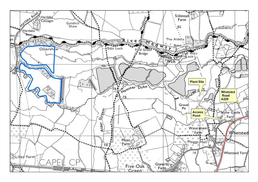
•   Overnight lorry parking;
        •   Operation Stack; and,
        •   managing the routing of Heavy Goods Vehicles (HGV) to ensure that they remain
            on the Strategic Road Network (SRN) for as much of their journey as possible
            reducing impacts of freight traffic on communities and the environment while
            encouraging sustainable distribution

Figure 1 Transport Links

4.0 Methodology
4.0.1 Mineral sites were identified as suitable ‘in principle’ following a comprehensive site
      evaluation process that is set out in the ‘Site Identification and Methodology’ document.
      Identification of these sites considered a number of impacts including those resulting
      from vehicle transport to and from the site.

      The process of site assessment involved two stages:

      1. Initial Screening
      2. Detailed Technical Assessment

4.1 Initial Screening
4.1.1 The initial screening exercise involved an assessment of whether sites were likely to
      cause unacceptable impacts and so should be screened out from the further
      consideration and whether further information was required. This initial screening utilised
      a refined ‘traffic light’ system based on a Red, Red-Amber, Amber, Amber-Green and
      Green (or RAG) scoring methodology. The RAG process was primarily a desk-based

Collated Transport Assessments of the Mineral Sites, April 2019
Page 6 of 35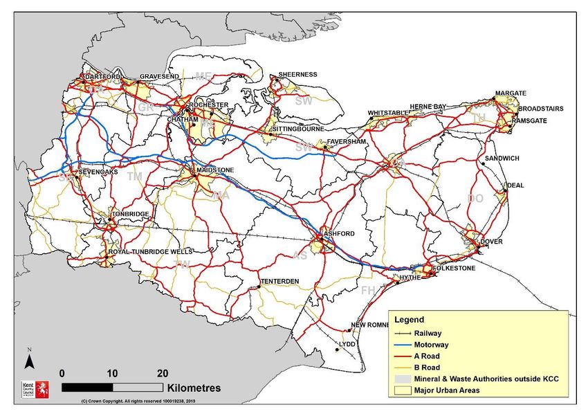
procedure, supported by site visits, and, in terms of transport impacts, assessed sites as
         being within the following categories depending on their anticipated level of impact.

                                RAG Sensitivity Score
 Transport (Including           The site could have a     The site could have a      The site could have a        The site could have a       The site will not give     GIS data
 Access)                        severe unacceptable       major adverse impact       moderate adverse             minor adverse impact        rise to any adverse
                                adverse impact on         on transport and           impact on transport and      on transport and            impacts upon transport     Officer assessment
 Key considerations:            transport and access in   access in the              access in the absence        access in the               and access to Primary
                                the absence of high       absence of high level      of medium level              absence of low level        and Secondary Route        Promoter of site
 Proximity to Kent's Trunk      level mitigation.         mitigation.                mitigation.                  mitigation.                 Network.
 Roads, Primary Route
 Network and Secondary          There are severe issues   There are major issues     There are moderate           There are minor issues
 Route Network will be          with access to the        with access to the         issues with access to        with access to the
 assessed, including the        Primary Route Network     Primary Route Network      the Primary Route            Primary Route Network
 presence of width, height      and Secondary Route       and Secondary Route        Network and                  and Secondary Route
 and weight restrictions        Network.                  Network.                   Secondary Route              Network.
 along these routes                                                                  Network.
                                Mitigation is not         The identified impacts                                  The identified impacts
                                practical.                could be mitigated in      The identified impacts       could l i k el y be
                                                          principle but this might   could be mitigated           mitigated
                                                          not be deliverable.        through planning             through planning
                                                                                     obligations.                 obligations.

 Services and Utilities         The site contains         The site contains          The site contains            The site is near to         There are no services      Officer
                                services or utilities     services or utilities      services or utilities that   services or utilities and   or utilities near to, or
4.1.2     The promoted mineral sites were submitted for consideration and were RAG scored.
 Key considerations:            which could be severely   which could require        would require                any minor adverse
                                                                                                       assessment Utility                     within the site.
                                impacted on and no        major mitigation           consideration                impacts may require
          This        initial
 Sites need sustainable
                              screening included
                                mitigation       those sites that were not in alignment
                                                          through rerouting, and/       with requirements
                                                                                     through re-routing or
                                                                                                       providers  low-level mitigation.
 access tofor     minerals set out in the adopted Kent Minerals and Waste Local Plan (2013-30). The
             utilities.         measures can be used.     or the location of         other medium levels of
                                                          cables/pipes hampers       mitigation        Promoter of site
 Equally, sites
           they should assessed
                         not      were as follows:        the ability to
 interfere with any utilities                             maximise capacity yield
 which pass underneath.                                   from the site.
         Brickearth (not in alignment with adopted KMWLP as further brickearth reserves
 Mitigation measures will
 be considered in terms of
         not required over the adopted plan period)
 cost and benefits.

 Utilities include water,
            •       M1: Paradise Farm, Sittingbourne
 gas, electricity and
 telecommunications, as
 well as railways, HS1
         Chalk (not in alignment with adopted KMWLP as further chalk reserves not
 and Crossrail assets.

         required over the adopted plan period)

            •       MW4: Hegdale Quarry (extension) Challock                                                                                                                                  173

         London Clay (not in alignment with adopted KMWLP as further clay reserves not
         required over the adopted plan period)

            •       MW3: Norwood Quarry, Isle of Sheppey

         Sub-Alluvial Terrace Sharp Sands and Gravel

            •       M7: Land at Central Road, Dartford
            •       M9: The Postern, Tonbridge
            •       M10: Moat Farm, Five Oak Green, (Tonbridge)
            •       M11: Joyce Green Farm Quarry Extension, Dartford
            •       M12: Postern Meadows, Tonbridge
            •       M13: Stonecastle Farm, Hadlow/Whested

         Storm Beach Sands and Gravel

            •       M2: Lydd Quarry Extension and Allens Bank, Lydd

         Soft Sands-Folkestone Beds

            •       M3: Chapel Farm (East and West), Lenham

Collated Transport Assessments of the Mineral Sites, April 2019
Page 7 of 35
•   M5: Wrotham Quarry Extension, Wrotham/Sevenoaks
           •   M6: Mount Castle Farm, Lenham
           •   M8: West Malling Sandpit, Ryarsh
           •   M14: Double Quick Farm, Lenham Heath

      Sands and Gravels-Lambeth Group (not in alignment with adopted KMWLP as
      not recognised as an economic aggregate yielding deposit)

           •   MW5: Wey Street, Faversham
           •   MW6: Collarmakers Quarry, Ash

4.2 Detailed Technical Assessment
4.2.1 Having screened out those mineral sites for which the adopted Kent Minerals and Waste
      Local Plan 2013-30 had not identified a specific requirement and/or those sites that had
      not passed the initial RAG screening stage, detailed technical assessment of the
      remaining ‘Option’ sites was undertaken. It should be noted that the sites ruled out at the
      initial screening stage were for reasons/impacts other than those relating to
      transportation.

4.2.2 The Option sites considered at the Detailed Technical Assessment stage were as
      follows:

      Soft Sands-Folkestone Formation

           •   M3: Chapel Farm, Lenham
           •   M8: West Malling Sandpit, Ryarsh

      Storm Beach Sands and Gravel

           •   M2: Lydd Quarry/Allen’s Bank Extension, Lydd

      Terrace and Sub-Alluvial Terrace Sharp Sands and Gravel

           •   M7: Land at Central Road, Dartford
           •   M9: The Postern, Capel - Sharp Sand and Gravels
           •   M10: Moat Farm, Five Oak Green, Capel
           •   M11: Joyce Green Farm Quarry Extension, Dartford
           •   M12: Postern Meadows, Tonbridge
           •   M13: Stonecastle Farm Quarry Extensions, Hadlow/Whested

4.2.3 The assessment involved requests for further information from site promoters regarding
      the transportation associated with development at the site. This information included:

       -       Likely HGV vehicle movements per day
       -       Likely movements of other vehicles per day
       -       Times of day when vehicle movements would occur
       -       An understanding of the routes taken
       -       Any measures proposed to mitigate transport impacts
       -       Anticipated growth from non-mineral development in the general locality

4.2.4 The County Council’s Highways teams assessed the transport impact of the Option sites
      in terms of:

Collated Transport Assessments of the Mineral Sites, April 2019
Page 8 of 35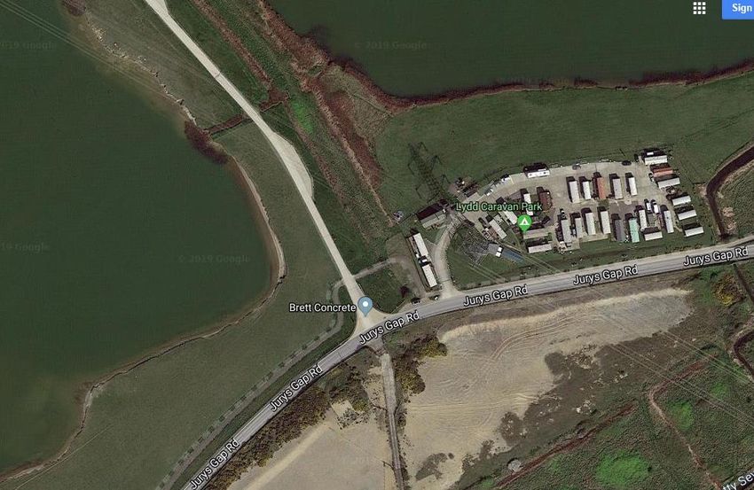
•   Acceptability of access arrangements. This included assessment of the accesses
           that were in place for sites that were extensions to established mineral sites. This
           included assessing impacts in relation to established highway safety criteria for
           operational mineral sites using the public highway, where new access points have
           to be formed and details had been supplied by the site promotor, the highway
           visibility and vehicular turning radii geometries were assessed for acceptability.
       •   The capacity of the immediate highway network capacity to accommodate the
           estimated HGV movements. This took into account the anticipated growth in the
           location from non-mineral development identified in any relevant local or
           neighbourhood plan.

5.0 Results and conclusions
5.0.1 Initial Screening

      The results of the initial screening of all sites are included in the Mineral Sites Plan,
      Mineral Site Selection-Initial Assessment document, amended January 2018. The RAG
      scoring results of the sites are included in Appendix 1 of this document (see document
      KCC/SP28
      http://mylimehouse.kent.gov.uk/portal/second_call_for_sites_2016/document_library).

5.1 Site: M3 Chapel Farm (West) - Folkestone Beds Soft Sand

5.1.1 Detailed Technical Assessment

      The following baseline parameters were considered for this Option site:

       •   Likely HGV vehicle movements per day = 3.20mt of reserves extracted at a rate of
           150,000 tonnes per annum gives a 21-year life. Assuming 260 working days per
           year and 20 tonnes (8 wheeler) HGV payload gives 7,500 loads per year (15,000
           movements) or 58 HGV movements per working day.
       •   Times of day when vehicle movements would occur = not specified by the site
           promotor, normal working hours assumed (typically Mon-Fri 7.00am-17.30pm,
           Sat 7.00 -12.00pm).
       •   Routes taken to access the site: the site would be approached by the A20 to the
           north and a dedicated new access point would be developed to enable safe
           access and egress from the site onto the A20. The route to the site would be via
           an established agricultural track (via a rail crossing bridge) to the site.
       •   Any measures proposed to mitigate transport impacts: dedicated new access to
           meet current highway standards.

Collated Transport Assessments of the Mineral Sites, April 2019
Page 9 of 35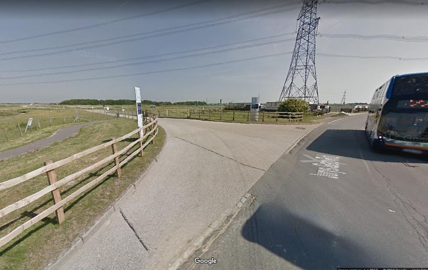
Figure 2 Location Map Chapel Farm (West) showing access point onto A20 to the
north (Ashford Road)

5.1.2 The proposed access is shown in the site location plan above (Figure 2); it spans north
      from the proposed working area, across a railway line, and meets the A20 Ashford Road.
      The A20 is part of the primary route network which is designed to accommodate HGV
      movements. It is considered that the level of additional vehicle movements (estimated
      at some 58 movements per working day averaged out over a 260-day working year) is
      very low such that the A20 would be able to accommodate the additional traffic without
      adverse impacts. A new access onto the A20 would require careful design with
      appropriate visibility splays. Indicative scaled drawings of the visibility splays and turning
      radii of a new access at onto A20 have been considered as acceptable in principle. A
      new access directly onto the A20 (see Figures 3 and 4) will negate any need for access
      to the site via rural roads in the area.

Collated Transport Assessments of the Mineral Sites, April 2019
Page 10 of 35
Figure 3 Chapel Farm access point onto A20 Ashford Road (not to scale: Cannon Consulting Engineers © 2018) Figure 4 Chapel Farm area of promoted access point onto A20 Ashford Road (Imagery © Digital Globe, Getmappling Plc) Collated Transport Assessments of the Mineral Sites, April 2019 Page 11 of 35
5.1.3 In the initial site submission, the access track was proposed to line the edge of the land in
      the control of the landowner. This was deemed to be unacceptable as it did not allow
      sufficient room for visibility splays to be maintained. The proposed access has been
      moved westward so that the visibility splays can be accommodated by land in the control
      of the landowner. Hence the pronounced ‘dog leg’ to the access track to the A20 (see
      Figure 2). Figure 5 shows the approximate location on the A20 of the access point looking
      east.

Figure 5 Chapel Farm area of promoted access point onto A20 Ashford Road looking
east (Imagery © Digital Globe, Getmappling Plc)

5.1.4 In terms of cumulative impacts on the highway network with other planned development
      in the area (For example, the village of Lenham and nearby Harrietsham are proposed
      to be expanded within Maidstone Borough Council’s Local Plan (adopted October
      2017)), it is considered that the development would not result in the addition of significant
      vehicle numbers to the highway network. Further information regarding forecasts and
      impact on the road network would be required and assessed as part of a transport
      assessment in support of a planning application. Although invited, no specific concerns
      have been raised by Highways England on this site. Utilisation of the railway is not
      considered practical by the site promoter at this time. However, this may be potentially
      considered further at the detailed planning application stage.

5.1.5 Conclusion

5.1.6 It is considered that the site can be operated in a way which would not cause an
      unacceptable adverse impact on the highway network subject to the following matters
      being addressed at any implementation stage:

       •   A detailed Transport Assessment to demonstrate compliance with KMWLP Policy
           DM 13 to accompany any planning application.

Collated Transport Assessments of the Mineral Sites, April 2019
Page 12 of 35
• The Transport Assessment should consider ability to access the site via rail, impacts
on the A20 and the Maidstone AQMA and show how any potential adverse impacts
on this AQMA will be mitigated.
5.2 M8: West Malling Sandpit, Ryarsh- Folkestone Beds Soft Sand
5.2.1 Detailed Technical Assessment
5.2.2 The following baseline parameters were considered for this Option site:
• Likely HGV vehicle movements per day (as stated by promoter) = 3.10mt of
reserves extracted (and 0.5mt of silica sand) at a rate of 150,000 tonnes per
annum gives a 24-year life with 70 HGV movements per working day for both
extraction and waste inputs (restoration).
• Times of day when vehicle movements would occur = not specified by the site
promotor, normal working hours assumed (typically Mon-Fri 7.00am-17.30pm,
Sat 7.00 -12.00pm).
• Routes taken to access the site: the site would be approached by the London
Road A20 to the south and then via Roughetts Road to an access point on the
site’s eastern boundary.
• Any measures proposed to mitigate transport impacts: dedicated new access in
Roughetts Road to meet current highway standards (no technical details
submitted).
Collated Transport Assessments of the Mineral Sites, April 2019
Page 13 of 35Figure 6 Site Location Plan West Malling Sandpit access via dedicated new access
point of Roughetts Road
5.2.3 The promoted site is shown in Figure 6. The promoter submitted a highways and
transport assessment which considered whether Roughetts Road, to the east of the site,
would have sufficient capacity as a road link onto the a20. This assessment suggested
that the road has capacity for 1,020 two-way vehicles per hour, and it is currently
operating at well below this (210 vehicles). Furthermore, London Road (A20) (which
would connect the site to the Strategic Route Network (SRN)) is also operating at well
below its threshold. It was therefore concluded that both roads (see Figure 7) have
sufficient capacity to accommodate the forecasted increase in vehicle movements. This
methodology factored in the anticipated background local non-minerals development
growth rates to 2030.
Collated Transport Assessments of the Mineral Sites, April 2019
Page 14 of 35Figure 7 Roughetts Road and London Road (A20) (Imagery © Digital Globe, Getmappling
Plc)
5.2.4 The concern that the junction of Roughetts Road and the London Road (see Figure 8)
does not have capacity to accommodate regular HGV movements is also addressed
which concludes that the junction is currently operating below the recognised threshold
at both AM and PM hours and so it is considered that the junction could accommodate
the anticipated quarry traffic.
Collated Transport Assessments of the Mineral Sites, April 2019
Page 15 of 35Figure 8 London Road (A20) with junction onto Roughetts Road (looking west) (Imagery
© Digital Globe, Getmappling Plc)
5.2.5 Whilst recognising that Roughetts Road has previously been used by HGVs to access
the former Ryarsh Brickworks site (now a housing development off Quarry Road) and
the former Workhouse Quarry (off Workhouse Road), the Local Highway Authority had
concerns that the promoter’s highways and transport assessment was deficient in a
number of minor aspects. Ultimately however, the Local Highway Authority consider that
it is possible to operate the site in a manner that would not result in unacceptable impacts
on the road network. This is subject to any application fully addressing the following
matters:
• The need for any localised road widening on Roughetts Road to accommodate turning
movements to and from a dedicated site access.
• The need for regular road condition surveys to be carried out during the operation
period with maintenance provided where required.
5.2.6 If an acceptable proposal were to come forward for mineral development in this location
an appropriate condition(s) would be imposed relating to HGV or other vehicle routing
and this would include a prohibition of HGVs (or other vehicles if deemed necessary)
from turning left out of the site entrance (to the north) or right into the site entrance (from
the north). In this way all HGVs (or other vehicles if deemed necessary) would be
required to travel to and from the A20 via that section of Roughetts Road to the south of
the proposed site entrance (see figure 9). If HGVs travel the wrong way and enter or
leave the site from / to the north, the operator could be served with a breach of condition
notice. Such a requirement would avoid vehicles using unsuitable country roads to
access the site from the north.
Collated Transport Assessments of the Mineral Sites, April 2019
Page 16 of 35Figure 9 Approximate are of proposed site access on the right of Roughetts Road
(looking north) (Imagery © Digital Globe, Getmappling Plc)
5.2.7 Conclusion
5.2.8 It is considered that the site can be operated in a way which would not cause an
unacceptable adverse impact on the highway network subject to the following
matters being addressed at any implementation stage:
• A detailed Transport Assessment to demonstrate compliance with KMWLP
Policy DM13.
• The Transport Assessment to assess the need for any localised road widening
on Roughetts Road to accommodate turning movements to and from a
dedicated site access. Together with regular road condition surveys to be carried
out during the operational period with maintenance provided where required.
5.3 M2: Lydd Quarry/Allen’s Bank Extension, Lydd-Storm Beach
Deposits
5.3.1 Detailed Technical Assessment
5.3.2 The following baseline parameters were considered for this Option site:
• Likely HGV vehicle movements per day (as stated by promoter) = 3.10mt of
reserves extracted at a rate of 250,000 tonnes per annum gives a 12.5-year life
with 96 HGV movements per working day for extraction of the deposit.
Collated Transport Assessments of the Mineral Sites, April 2019
Page 17 of 35• Times of day when vehicle movements would occur = promoter states working
hours as Mon-Fri 7.00am-18.00pm, Sat 7.00 -13.00pm.
• Routes taken to access the site: the site would be approached by Jury’s Gap Road
to the west of Lydd, the established access point to the extant quarry working
processing site (situated to north west of parcel 22 as indicated on Fig. 10).
• Any measures proposed to mitigate transport impacts: Use of existing plant site
and access is facilitated by the use of linking conveyor systems.
Figure 10 Site Location Plan Lydd Quarry and Allens Bank access via established
access Jury’s Gap Road
Collated Transport Assessments of the Mineral Sites, April 2019
Page 18 of 35Figure 11 Existing Lydd Quarry Access on to Jury Gap’s Road, Lydd (Imagery © Digital
Globe, Getmappling Plc)
5.3.3 The promotor has confirmed that the existing processing plant site and access point onto
Jury Gap’s Road would be used for the promoted extension area (see figures 11 and
12).The current planning permission for the existing Lydd Quarry works states that there
should be no more than 250 HGV movements a day. The County Council as Local
Highway Authority are of the view that continuation of this level of intensity over the
period of the additional mineral extraction would not warrant an objection to the promoted
site, given that it will generate no extra vehicle movements than the permitted quarry
development.
5.3.4 This position is caveated by the County Highways Authority being satisfied that the
existing minerals working (relating to the 2007 planning application) would be fully
extracted first and the two implemented planning permissions would not operate at the
same time. Moreover, any new planning permission for the proposed extension areas
would require a condition to limit the site to 250 HGV movements a day (125 in / 125 out)
in order to maintain the same level of intensity.
5.3.5 Road maintenance is a matter that the County Council has to respond to in its role as the
County Highways Authority when it is determined that road surfaces and or design
requires maintenance or change
Collated Transport Assessments of the Mineral Sites, April 2019
Page 19 of 35Figure 12 Existing Lydd Quarry Access on to Jury Gap’s Road, Lydd, looking east
(Imagery © Digital Globe, Getmappling Plc)
5.3.6 Conclusion
5.3.7 It is considered that the site can be operated in a way which would not cause an
unacceptable adverse impact on the highway network subject to the following matters
being addressed at any implementation stage:
• A detailed Transport Assessment to demonstrate compliance with KMWLP Policy
DM 13 to accompany any planning application.
• The Transport Assessment to assess the need for any localised road condition
surveys to be carried out during the operational period to enable maintenance of the
highway to be addressed where required.
5.4 M7: Land at Central Road, Dartford
5.4.1 Detailed Technical Assessment
5.4.2 The following baseline parameters were considered for this Option site:
• Likely HGV vehicle movements per day (as stated by promoter) = 0.8-0.9mt of
reserves extracted at a rate of 90,000 tonnes per annum gives a 10-year life with
an estimated 36 HGV movements per working day for extraction of the deposit.
(assuming a 260 working day year and 20 tonnes pay load HGV being
employed)
Collated Transport Assessments of the Mineral Sites, April 2019
Page 20 of 35• Times of day when vehicle movements would occur = not specified by the site
promotor, normal working hours assumed (typically Mon-Fri 7.00am-17.30pm,
Sat 7.00 -12.00pm).
• Routes taken to access the site: the site would be approached via Bob Dunn
Way (A206) in Dartford (that bounds the site to the north), the access point
would have to be created off Central Road (that bounds the site on its eastern
boundary), no details were specified by the promoter.
• Any measures proposed to mitigate transport impacts: None specifically
proposed.
Figure 13 Site Location Plan Land at Central Road, Dartford
5.4.3 Locationally, the site would access a strategically important part of the national road
network (M25/Junction 1a Dartford Crossing), which is particularly sensitive to
congestion see Figures 13 and 14.
Collated Transport Assessments of the Mineral Sites, April 2019
Page 21 of 35Figure 14 Option sites Joyce Green and Central Road and A206 (Bob Dunn Way) and
Junction 1a interchange with A282 approach to Dartford Crossing/M25
5.4.4 Kent County Council Highways, as local highway authority, objects to the proposed
allocation. It advises that the local highway network in this location is extremely sensitive
and any impact to the network and the air quality must be mitigated. Additional
information was required before the Highway Authority could be satisfied in principle that
the allocation is acceptable for mineral development, given the highway capacity and air
quality sensitivities in Dartford and around Junction 1a. This includes:
• A capacity assessment of the Bob Dunn Way/Joyce Green Lane/ Central Road
roundabout that takes account of the committed development of the recently
approved application: KCC/DA/0320/2017, Joyce Green Quarry, Joyce Green Lane,
Dartford, Kent, DA1 5PN.
• Further details of the access arrangement details to ensure a safe suitable point of
access can be achieved, with appropriate visibility splays to be provided. Pedestrian
and cycle access must also be considered when designing the access.
5.4.5 This information was not provided and, in its absence, the impact on local highway
capacity could not be fully assessed. Furthermore, Highways England have advised that
any mineral site allocations need to ensure that they do not impact the safe and efficient
operation of the SRN, in this case the nearby M25 and in particular the interconnection
at Junction 1a with the A282 Dartford Crossing and M25 approach road (see Figure 14).
It is noted that Central Road is located approximately some 2km from this junction and
Collated Transport Assessments of the Mineral Sites, April 2019
Page 22 of 35that access to the site would be obtained from Central Road, which adjoins directly to the
A206 Bob Dunn Way and then onto junction 1a. This area is particularly sensitive for
traffic congestion issues which have a negative impact on air quality. As such, several
areas around Dartford have been designated as AQMA’s, including Dartford Town
Centre which is to the south of the site, and within the London Borough of Bexley to the
west.
5.5.6 Conclusion
5.5.7 In light of the highway objection, the County Council considers that even modest traffic
increase will have potentially significant adverse impacts on traffic. In particular, these
relate to highway impacts on Bob Dunn Way (A206) and the A282 (Dartford Crossing
and M25 approach road) Junction 1a conditions and air quality, particularly when viewed
cumulatively with other planned development in the Dartford Local Plan.
5.6 M11: Joyce Green Farm Quarry Extension, Dartford - Sharp Sand and
Gravel
5.6.1 Detailed Technical Assessment
5.6.2 The following baseline parameters were considered for this Option site:
• Likely HGV vehicle movements per day (as stated by promoter) = 2.0mt of
reserves extracted at a rate of 150,000 tonnes per annum gives a 10-13-year life
with an estimated 60 HGV movements per working day for extraction of the
deposit (plus 12 car/van vehicular movements per day) with restoration material
inputs the daily HGV movements increase to an overall 116-174 two-way
movements per day.
• Times of day when vehicle movements would occur = working hours as Mon-Fri
7.00am-18.00pm, Sat 7.00 -13.00pm (specified by promoter).
• Routes taken to access the site: the site would be approached via Bob Dunn
Way (A206) in Dartford and roundabout with Joyce Green lane, access to the
site would be via the established quarry site access point in Joyce Green Lane.
• Any measures proposed to mitigate transport impacts: the promotor states that
an estimated 75% of the quarry’s output would serve the London market to the
west, avoiding the issue of increased congestion at Junction 1a.
Collated Transport Assessments of the Mineral Sites, April 2019
Page 23 of 35Figure 15 Site Location Plan Land at Joyce Green, Dartford
5.6.7 The Local Highway Authority (Kent County Council) has considered the site (see Figure
15) in relation to the capacity of the local roads to accommodate further HGV movements
without adverse and unacceptable impact on the local highway network (with particular
regard to Bob Dunn Way (A206) and its junction 1A (interchange onto the A282 Dartford
Crossing approach see Figure 14). The excavation and restoration activity are
anticipated to be in the order of 116-174 two-way HGV movements per day for the
mineral extraction as well as for the revised restoration proposal, which involves the
importation of restoration materials for habitat recreation purposes.
5.6.8 The transportation assessment work concluded that the site would result in unacceptable
highway impacts in the immediate locality and in particular at junction 1a (the interchange
with A206/A282 M25 and Dartford Crossing approach see Figure 14) with the close
Collated Transport Assessments of the Mineral Sites, April 2019
Page 24 of 35proximity of the SRN (M25). The Local Highway Authority has stated:
“The potential of the site to exacerbate traffic congestion around the M25/A282 junction
1A is of concern to the County Council. This location is one of the most strategically
important yet least resilient parts of the national road network. It is considered by the
County Council that even modest traffic increase will have potentially sizeable impacts
on traffic conditions, particularly when viewed cumulatively with the other planned
development as identified by the Dartford Local Plan for the area. It is the case that the
Dartford crossing has been either partially or completely closed, for an average of 300
times per year (for 30 minutes or more). This can cause between 3 to 5 hours for roads
to clear following a closure. This can cause blocking back on the northbound approach
to the river crossing directly affecting the operation of Junction 1a. Vehicles waiting to
travel northbound on the M25/A282 typically queue beyond the end of the slip road and
through the western roundabout of Junction 1a. Traffic congestion on the local road
network is often a direct consequence of traffic seeking alternative routes to avoid
incidents and queuing on the M25/A282 mainline.”
5.6.9 On this basis, the Local Highway Authority raises objection to the promoted site. This
conclusion has been reached with knowledge of the promoter’s efforts to demonstrate
that the proposals would result in an increase of just 6 HGV trips (12 movements) above
current levels in the peak periods. Together with the site’s main market being
substantively westwards, towards Greater London, and away from junction 1A on the
A206/A282 interchange.
5.6.10 Highway England shares the concern about the resilience of the strategic network in
this location and considers that the site would have an impact on M25 Junction 1a, an
already congested junction. Any proposal that substantively increased HGV
movements associated with the transportation of inert restoration materials is unlikely
to be acceptable. Further detailed transport evidence would be required, setting out the
transport implications of the mineral development, and demonstrating that the vehicle
movements associated with the extension of the site will not materially affect the safety,
reliability and/or operation of the SRN.
5.6.11 It is noted that the promoter prepared additional details of the potential traffic impact
of the site being worked and restored, however Highways England did not provide any
further comment. The promoter had examined the potential use of the River Thames
and River Darent for the import and export of material. Lack of commercial navigation
of the lower River Darent and the existence of substantial river defences along the River
Thames makes any such proposal impracticable.
5.6.12 Conclusion
5.6.13 In light of the highway authority objection, and the concern expressed by Highway
England with the proposals that have the potential to impact the safe and efficient
operation of the SRN in this case the M25 (and in particular Junction 1a), the County
Council considers that even modest traffic increase will have potentially significant
adverse impacts on traffic. These relate to highway impacts on Bob Dunn Way (A206)
Collated Transport Assessments of the Mineral Sites, April 2019
Page 25 of 35and the A282 (Dartford Crossing and M25 approach road) Junction 1a conditions and
air quality, particularly when viewed cumulatively with other planned development in
the Dartford Local Plan.
5.7 M9 The Postern, Capel - Sharp Sand and Gravels
5.7.1 Detailed Technical Assessment
5.7.2 The following baseline parameters were considered for this Option site:
• Likely HGV vehicle movements per day = as calculated given the estimated
resource of 600,000 tonnes extracted over 5 years giving an estimated 46 HGV
movements per working day for extraction of the deposit, assuming a 260
working day year and 20 tonnes pay load HGV vehicles being employed.
• Times of day when vehicle movements would occur = not specified by the site
promotor, normal working hours assumed (typically Mon-Fri 7.00am-17.30pm,
Sat 7.00 -12.00pm).
• Routes taken to access the site: The site can be approached via Postern Lane
though this is unsuitable for HGVs; access via an established (disused quarry
access) on the A26 Hadlow Road (Primary Route Network) 1km to the north was
considered but not secured.
• Any measures proposed to mitigate transport impacts: None specifically
proposed.
5.7.3 Conclusion
5.7.4 Site withdrawn by Promoter from further assessment due to being unable to
demonstrate an acceptable access.
5.8 M10: Moat Farm, Five Oak Green, Capel
5.8.1 Detailed Technical Assessment
5.8.2 The following baseline parameters were considered for this Option site:
• Likely HGV vehicle movements per day = as calculated given the estimated
resource of 1.5 million tonnes extracted over 15 years giving an estimated
extraction rate of 100,000 tonnes per annum, giving 38 HGV movements per
working day for extraction of the deposit, assuming a 260 working day year and 20
tonnes pay load HGV vehicles being employed.
• Times of day when vehicle movements would occur = not specified by the site
promotor, normal working hours assumed (typically Mon-Fri 7.00am-17.30pm, Sat
7.00 -12.00pm).
• Routes taken to access the site: the site would use the adjoining established
Stonecastle Farm Quarry processing site and access to the Whetsted
Road/Maidstone Road A228 highway.
Collated Transport Assessments of the Mineral Sites, April 2019
Page 26 of 35• Any measures proposed to mitigate transport impacts: The promotor of the site
states that the site would not work concurrently with Stonecastle Farm to the north,
but sequentially to avoid increasing the HGV movements on local roads.
Figure 16 Moat Farm, Five Oak Green, Capel
5.8.2 Provided any extraction at Moat Farm (see Figure 16) (where use of the adjoining
Stonecastle Farm Quarry processing site and access to the Whetsted Road will be
required, see Figures 17 and Figure 18) is not concurrent with extraction of any reserves
at Stonecastle Farm; and this does not exceed the current level of permitted extraction
as permitted for the existing planning permission at the Stonecastle Farm site, the
highway impacts associated with the site would be acceptable.
Collated Transport Assessments of the Mineral Sites, April 2019
Page 27 of 35Figure 17 Stonecastle Farm Quarry processing site and access to the Whetsted
Road(Imagery © Digital Globe, Getmappling Plc)
Figure 18 Stonecastle Farm Quarry access to the Whetsted Road (Imagery © Digital
Globe, Getmappling Plc)
Conclusion
5.8.3 The County Council’s assessment of the potential impacts on highways and
transportation concluded the development of the site, as promoted, would be acceptable
in highway terms.
5.9 M12: Postern Meadows, Tonbridge
5.9.1 Detailed Technical Assessment
5.9.2 The following baseline parameters were considered for this Option site:
Collated Transport Assessments of the Mineral Sites, April 2019
Page 28 of 35• Likely HGV vehicle movements per day = as given by the promoter the estimated
resource of 230,000 tonnes extracted over 3 years giving an estimated extraction
rate of 76,000 tonnes per annum, giving 30 HGV movements and 6 car/light van
vehicles per working
• Times of day when vehicle movements would occur = working hours as Mon-Fri
7.00am-18.00pm (no Saturday working specified by promoter).
• Routes taken to access the site: the site access would use of the adjoining
industrial estate access onto the A26, though HGV traffic would have to cross
Postern Lane to reach the industrial estate.
• Any measures proposed to mitigate transport impacts: None specifically proposed.
Figure 19 Postern Meadows, Tonbridge
5.9.3 Access to the site (see Figure 19) would cross Postern Lane, before being sought through
“Postern Industrial Estate” and meeting the A26. The site is on the outskirts of Tonbridge
town, so traffic levels are already considered high in the area. The junction with Vale
Road is a simple priority junction and scope for improvements is limited due to the river
bridge immediately to the north of the site access. Vale Road and the adjoining highway
network is already congested at peak times and therefore any significant intensification
would need to be avoided.
Collated Transport Assessments of the Mineral Sites, April 2019
Page 29 of 355.9.4 There is concern over the capacity of the local highway network, and the suitability of
HGVs crossing Postern Lane on a regular basis, as it constitutes a country road which is
unsuitable for quarry traffic. Any alternative access would require travelling further along
Postern Road, which would not be appropriate.
5.9.5 No information has been submitted to assess the impact of the site on the highway
network or demonstrate the suitability of such an access.
5.9.6 Conclusion
The County Council’s assessment of the potential impacts on highways and
transportation concluded the development of the site, as promoted, would be acceptable
in highway terms.
5.10 M13: Stonecastle Farm Quarry Extensions, Hadlow/Whested
5.10.1 Detailed Technical Assessment
5.10.2 The following baseline parameters were considered for this Option site:
• Likely HGV vehicle movements per day = the estimated resource of 1.0 million
tonnes extracted over 7 years giving an estimated extraction rate of 142,860
tonnes per annum, giving 55 HGV movements (based on 20 tonne pay load HGV
use and a 260 day working year) and 10 car/light van vehicles per working day
• Times of day when vehicle movements would occur = working hours given as
Mon-Fri 7.00am-18.00pm, 07.00am-13.00 Saturday.
• Routes taken to access the site: the site, as an extension, would use of the
established Stonecastle Farm Quarry site access to the Whetsted
Road/Maidstone Road A228 highway.
• Any measures proposed to mitigate transport impacts: The promotor of the site
states that the site would not work concurrently with Moat Farm to the south, but
sequentially to avoid increasing the HGV movements on local roads.
Collated Transport Assessments of the Mineral Sites, April 2019
Page 30 of 35Figure 20 Stonecastle Farm (extension), Tonbridge
5.10.3 The promoter of the site (see Figure 20) submitted a Transport Assessment which
stated that the site would be served by the existing access to the established Stonecastle
Farm Quarry on Whetsted Road (see Figures 21 and 22), and all traffic would turn left out
of the site in accordance with the existing permission. The transport assessment states
that the quantum of HGV traffic is not proposed to change, and neither is the level of
employment on site. The report concluded that there would be no reason to exclude the
site on highway safety grounds, and that the existing access remains suitable subject to
minor repairs.
Collated Transport Assessments of the Mineral Sites, April 2019
Page 31 of 35Figure 21 Stonecastle Farm Quarry (extension) and access onto A2287 Whetsted Road Figure 22 Established Access of Stonecastle Farm Quarry (Imagery © Digital Globe, Getmappling Plc) Collated Transport Assessments of the Mineral Sites, April 2019 Page 32 of 35
5.10.4 Planning permission for mineral extraction at Stonecastle Farm was most recently
             granted in 2017, where it was found that impacts on the highway were acceptable.
             Mitigation measures are already employed such as the prohibition of vehicles turning
             right on exiting the site to prevent them driving through surrounding villages and it is
             anticipated that these measures would remain in place for the future development to be
             acceptable.

       5.10.5 The Council’s Highways Officer considered that provided proposed extensions (that
             constitute the promoted site) do not result in an increase of number of vehicle trips per
             day (meaning that the site would not be worked concurrently to the existing permitted
             site) then the proposal would likely be acceptable. It is anticipated that the same
             conditions and restrictions would need to be imposed on the allocation as for the existing
             site. If this is the case, then the proposed allocation would not trigger the need for further
             mitigation.

       5.10.6 Conclusion

       5.10.7 The County Council’s assessment of the potential impacts on highways and
             transportation concluded the development of the site, as promoted, would be acceptable
             in highway terms.

       6.0 Summary
       6.1 This report sets out the results of the Detailed Technical Assessment of the potential
            transport impacts of the nine Option sites deemed to be reasonable alternatives. This
            followed the initial RAG screening of all the sites submitted by promoters following the
            2017 ‘Call for Sites’ exercise. This report should be read alongside the Minerals Local Plan
            Mineral Site Assessment 2018 (see document KCC/SP41) in the online Documents
            library6 that addresses other material planning considerations pertaining to the Option sites
            and the conclusions that support the allocation of Chapel Farm (West), Moat Farm and
            Stonecastle Farm in the Draft Mineral Sites Plan 2019-30.

6   http://consult.kent.gov.uk/portal/mwcs/mwlp-eip/eip-library/

       Collated Transport Assessments of the Mineral Sites, April 2019
       Page 33 of 35
Appendix 1: Results of the initial RAG scoring of all
promoted sites that align with the Kent Minerals and Waste
Local Plan 2013-30 with regard to transport impacts
Sub-Alluvial River Terrace and Deposits
• M7: Land at Central Road, Dartford
• M9: The Postern, Tonbridge
• M10: Moat Farm, Five Oak Green, (Tonbridge)
• M11: Joyce Green Farm Quarry Extension, Dartford
• M12: Postern Meadows, Tonbridge
• M13: Stonecastle Farm, Hadlow/Whested
Collated Transport Assessments of the Mineral Sites, April 2019
Page 34 of 35Storm beach gravel
• M2: Lydd Quarry Extension and Allens Bank, Lydd
Silica Sand/Construction Sand-Sandstone: Folkestone Formation
• M3: Chapel Farm (East and West), Lenham
• M5: Wrotham Quarry Extension, Wrotham/Sevenoaks
• M8: West Malling Sandpit, Ryarsh
• M14: Double Quick Farm, Lenham Heath
Collated Transport Assessments of the Mineral Sites, April 2019
Page 35 of 35You can also read