Flood and Water Management Act 2010 Section 19 Flood Investigation Report - Rhondda Cynon Taf County ...
←
→
Page content transcription
If your browser does not render page correctly, please read the page content below
Flood and Water Management Act
                         2010
                 Section 19 Flood Investigation
                             Report

                      Storm Callum - Brook Street
                             Aberaman

                                                  October 2019

ANDREW STONE
Strategic Projects Manager
Strategic Projects, Sardis House, Sardis Road, Pontypridd, CF37 IDU

NIGEL WHEELER
Group Director
Prosperity, Development and Frontline Services, The Pavilions, Clydach Vale, CF40 2X
Flood and Water Management Act 2010, Section 19 Flood Investigation Report   October 2019

                                     Blank Page
Flood and Water Management Act 2010, Section 19 Flood Investigation Report   October 2019

DOCUMENT VERIFICATION

Client                 Group Director Prosperity, Development and Frontline Services
                       Flood and Water Management Act 2010, Section 19 Flood
Project
                       Investigation Report
Document Title         Brook Street Aberaman
Document Ref           FRMR – 1001 – 19 – 01
Project No             N/A

Revision Status
                        Final
Date of Issue
                   October 2019
Prepared by

                   Owen Griffiths
                    MSc, BSc (Hons)

Checked by
                      A Stone
                    BSc (Hons), IEng,
                  MICE, Assoc, MCIWM
                         AaPS

Approved by

                      R Waters
                    BSc, C Eng MICE

This report should be read in its entirety

This report has been prepared in accordance with the requirements of section 19
Flood and Water Management Act 2010. The Council assumes no responsibility or
liability from any person in connection with its contents or findings.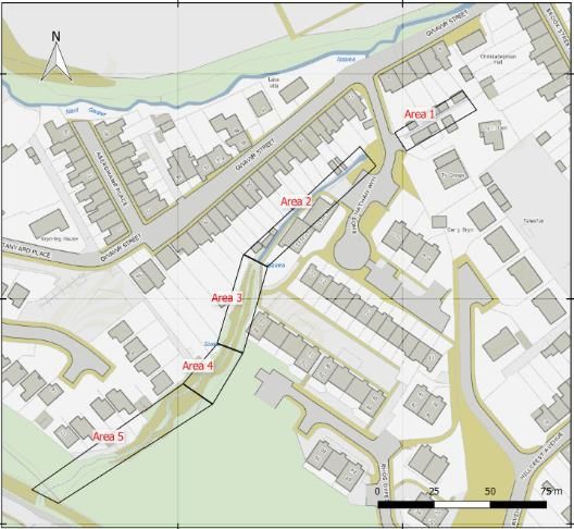
Blank Page
Flood and Water Management Act 2010
Section 19 Flood Investigation Report
October 2019

CONTENTS

1     EXECUTIVE SUMMARY .................................................................................... 1
INTRODUCTION ........................................................................................................ 3
    1.1    Purpose of Investigation ................................................................................ 4
    1.2    Site Location ................................................................................................. 4
    1.3    Drainage System........................................................................................... 5
    1.4    Investigation Evidence .................................................................................. 5
FLOODING HISTORY ............................................................................................... 6
    2.1    Previous Flood Incidents ............................................................................... 6
    2.2    Flood Incident................................................................................................ 8
    2.1    Rainfall Analysis .......................................................................................... 10
POSSIBLE CAUSES ............................................................................................... 13
    3.1    Culvert Conditions ....................................................................................... 13
    3.2    Open Watercourse Conditions .................................................................... 18
    3.3    Access Structures ....................................................................................... 20
    3.4    System at Capacity ..................................................................................... 20
RIGHTS AND RESPONSIBILITIES OF RISK MANAGEMENT AUTHORITIES ..... 22
    4.1    Lead Local Flood Authority ......................................................................... 22
    4.1    Natural Resources Wales ........................................................................... 24
    4.2    Water Company .......................................................................................... 26
5     ROLE OF OTHER AUTHORITIES ................................................................... 27
    5.1    Network Rail ................................................................................................ 27
    5.2    Highway Authority ....................................................................................... 27
    5.3    Riparian Landowners .................................................................................. 27
    5.4    Residents .................................................................................................... 28
PERMISSIVE POWERS OF RISK MANAGEMENT AUTHORITIES ....................... 29
CONCLUSION ......................................................................................................... 30
USEFUL LINKS/CONTACTS .................................................................................. 32
ABBREVIATIONS...................................................................................................... 3

                                                                                                                           i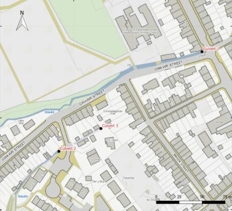
Flood and Water Management Act 2010
Section 19 Flood Investigation Report
October 2019

                                        Blank Page

                                                     ii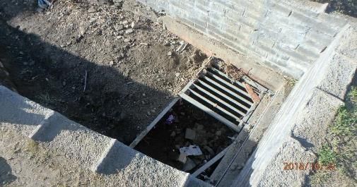
Flood and Water Management Act 2010
Section 19 Flood Investigation Report
October 2019

1 EXECUTIVE SUMMARY
This report has been produced through the duties placed upon Rhondda Cynon Taf
County Borough Council (RCT) under Section 19 of the Flood and Water Management
Act 2010. The Act states, “On becoming aware of a flood in its area, a lead local flood
authority must, to the extent that it considers it necessary or appropriate, investigate:

   a) which risk management authorities have relevant flood risk management
      functions and
   b) Whether each of those risk management authorities has exercised, or is
      proposing to exercise those functions in response to the flood”.

This Section 19 investigation provides a factual report of the storm event that occurred
on 12 and 13th of October 2018, within the Cynon and Rhondda Valley’s, focusing
investigation on the flooding at Brook Street Aberaman on the 13 th October.

The flooding that affected RCT on 12 and 13th October 2018, was a result of an
extreme rainfall event. The storm was preceded by 7 weather warnings being issued
by the Met Office ranging from; Yellow to Amber warnings with rainfall predictions
increasing closer to the 12th – 13th October. The Met Office designated the storm as
‘Storm Callum’,

The impact of the event at Brook Street Aberaman resulted in internal flooding to four
properties and flooded the highway. These impacts were identified through inspections
made by RCT’s Flood Risk Management Team on the 13th October.

It has been established from local residents, first responders and officers within the
Flood Risk Management team that the source of flooding originated from an unnamed
ordinary watercourse located west of Brook Street (Culvert 3), which identified a
200mm rectangular inlet where the surcharging occurred.

A review of Culvert 3 following post event inspections identified an ‘un-consented
structure’ within the culvert inlet, which appeared to be restricting the inlets efficiency
to convey the flow of the watercourse into the Nant Gwawr watercourse. Due to the
un-consented structure being erected by the riparian owner of Culvert 3. The Council
as the Land Drainage authority issued a warning letter to the riparian owner requiring
the un-consented structure to be removed. Following the issuing of the letter the
riparian owner removed the structure.

To support the investigation into the flooding at Brook Street a review of the
mechanism of flooding was undertaken utilising a hydraulic model; the model was

                                                                                   Page 1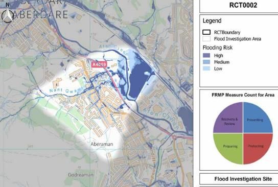
Flood and Water Management Act 2010
Section 19 Flood Investigation Report
October 2019

developed to investigate the capacity of the network and the effects of the local
catchment including tributaries and outfall influences.

The model identified the standard of protection of Culvert 3 both with and without the
unconsented structure. Following removal of the unconsented structure the culvert
was shown to provide a standard of protection from flooding up to and including the
Q100 +30% climate change event which represents current design standards for new
culverts. With the unconsented structure the standard of protection of Culvert 3 was
significantly reduced to Q30 + climate change.

The model further concluded that the Nant Gwawr watercourse had no influence on
the flooding at Brook Street on the 13th October. The results of the model demonstrate
that the likely cause of the internal flooding to the properties at Brook Street was a
result of the un-consented structure being erected by the owner of Culvert 3; which
reduced the standard of protection of Culvert 3 to Q30 + climate change. .

Following the results of the investigation into flooding at Brook Street and the
subsequent removal of the unconsented structure, RCT acting as the LLFA and LDA
do not intend to exercise any additional functions following the flooding event, however,
RCT will continue to work with residents in managing the local flood risk.

                                                                                Page 2
Flood and Water Management Act 2010
Section 19 Flood Investigation Report
October 2019

    ABBREVIATIONS
DCWW – Welsh Water

FRMP – Flood Risk Management Plan

FWMA – Flood and Water Management Act 2010

LDA – Land Drainage Authority

LFRMS – Local Flood Risk Management Strategy

LLFA – Lead Local Flood Authority

NRW – Natural Resources Wales

RCT - Rhondda Cynon Taff CBC

RMA – Risk Management Authority

SAB – Sustainable Drainage Approval Body

SuDs – Sustainable Drainage Systems

                                               Page 3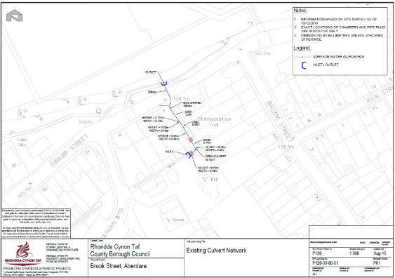
Flood and Water Management Act 2010
Section 19 Flood Investigation Report
October 2019

INTRODUCTION
      1.1      PURPOSE OF INVESTIGATION
On the 12 and 13th October 2018 Rhondda Cynon Taf County Borough Council (RCT)
was impacted by an extreme weather event which was designated by the ‘Met Office’
as ‘Storm Callum’ (Referred to in this report as the Storm).

The storm resulted in widespread residential and commercial flooding within the
Cynon and Rhondda Valley’s. This report will focus on the area of Brook Street
Aberaman.

The reason behind RCT’s investigation is in response to the duties of the local
authority in regards to Section 19; of the Flood and Water Management Act 2010,
which states:

1. “on becoming Aware of a flood in its area, a lead local flood authority must, to the
           extent that it considers it necessary or appropriate, investigate:

            a) “Which risk management authorities have relevant flood risk management
               functions and,
            b) Whether each of those risk management authorities has exercised, or is
               proposing to exercise, those functions in the response to the flood.”

2. “When an authority carries out an investigation under subsection (1) it must
   publish the results of its investigation, and notify any relevant risk management
   authority”1

      1.2      SITE LOCATION
The area investigated within this report is ‘Brook Street’ Aberaman, which is situated
within the Electoral Ward of ‘Aberaman North’ within the Cynon Valley. The Street is
situated adjacent the ‘Nant Gwawr’ Watercourse.

The area in question is identified within RCTs Flood Risk Management Plan (FRMP)
as an area of flood risk specifically identified within Flood Investigation area RCT0002
(Figure 1). The primary ordinary watercourse that conveys within the investigation area
is the ‘Nant Gwawr’; which is fed by a number of smaller unnamed tributaries that
convey water through a series of culvert networks to their outfall within the Nant
Gwawr.

1   Flood and Water Management Act 2010 – Section 19 - https://www.legislation.gov.uk/ukpga/2010/29/section/19

                                                                                                     Page 4
Flood and Water Management Act 2010
Section 19 Flood Investigation Report
October 2019
Figure 1: An excerpt of RCT’s FRMP Identifying Investigation Area RCT0002.
1.3 DRAINAGE SYSTEM
The surface water drainage system that serves the Brook Street area is that of the
highway drainage network designed to manage the surface water within the highway
and a public surface water sewer and combined sewer operated by Welsh Water.
1.4 INVESTIGATION EVIDENCE
To support the investigation a range of qualitative and quantitative evidence has been
gathered from numerous sources, the summary of which is listed:
Residents – Photos, Statements, Email correspondence
Responders statements – Local Responders statements
CCTV surveys – Internal surveys of the local culvert networks
Technical Note 1 – Channel Condition Report
Technical Note 2 – Hydraulic Performance Report
Met Office Data – Weather Warning information
Rain Gauges – Private and RCT operated gauge information
Project Appraisal Reports
RCT Flood Risk Management Plan
Natural Resources Wales – River Level Data
Page 5Flood and Water Management Act 2010
Section 19 Flood Investigation Report
October 2019
FLOODING HISTORY
2.1 PREVIOUS FLOOD INCIDENTS
Information relating to flood history is limited, however, local residents interested in the
flooding associated to Brook Street provided a range of dates that they state flooding
has occurred within the Aberaman area (Table 1), however, details associated to each
event were not available.
Date of Event Areas Affected
March 1998 Hillcrest Avenue,
Cardiff Road, Gwawr Street, Lord Street, Curre Street,
October 1998 King Street, Abergwawr Place, Brook Street, Tudor Place,
Holford Street, Mount Hill Street and Club Street,.
September 1999 Brook Street, Gwawr Street and King Street,
December 1999 Brook Street, Curre Street and Gwawr Street,
September 2000 Curre Street,
Rhos Nathan Wyn, Gwawr Street, Brook Street and
October 2000
Tanyard Place,
November 2000 Curre Street,
October 2001 Cardiff Road,
February 2002 Gwawr Street,
January 2004 Brook Street,
Brook Street, Tanyard Place, Gwawr Street and Mount
September 2004
Hill Street.
January 2005 Cardiff Road,
October 2005 Cardiff Road,
November 2006 Cardiff Road and Gwawr Street,
Cardiff Road, Gwawr Street, Hillcrest Avenue, Rhos Dyfed
December 2006
and Brook Street,
January 2007 Hillcrest Avenue and, Cardiff Road and Abergwawr Place,
King Street, Hill Street, Brook Street and Mount Hill
July 2007
Street,
December 2007 Gwawr Street, Cardiff Road and Tudor Place,
Holford Street, Cardiff Road, Belmont Terrace,
Blaengwawr Close, Tanyard Place, Penderyn Place, Mount
September 2008 Hill Street, Abergwawr Street, Hill Street, Gwawr Street,
Curre Street, Club Street, Sunnybank Street, Brook Street
and Greenhill Drive,
Table 1: Summarises a list of historic flooding stated by a resident interested in local flooding events.
Page 6Flood and Water Management Act 2010
Section 19 Flood Investigation Report
October 2019
Table 1 outlines 19 individual events of flooding within the Aberaman area, where 9
events directly reference flooding to Brook Street. The information provided by the
residents was limited regarding the extent of flooding, source or impact in terms of
property, business, infrastructure or environmental flooding.
Following the flood event the local residents who were impacted met with Flood Risk
Management staff and local councilors. One resident who had been flooded described
that they had ‘lived in the property for 40 years and that they had never experienced
flooding before’.
It is of note that high levels of historical flooding within the Aberaman catchment is
specifically associated with the ‘Nant Gwawr’ ordinary watercourse. In 2011, RCT
commissioned a ‘Project Appraisal’ Report; which was produced by ‘Capita Symonds’
to appraise possible options to alleviation flooding from the Nant Gwawr.
As part of the report, a historical review of flooding incidents was undertaken the
results of which identified 18 incidents of flooding between 1998 – 2008 which
specifically related to Brook Street. On review of the flood history it revealed that the
properties impacted on the 13th October flood event had not been previously flooded.
The previous flooding incidents refer to highway flooding i.e. blocked drains, and
overland flows from the Nant Gwawr. The results of the historical flooding review
suggests that the properties flooded by the 13th October 2018 flood event had not
previously been subject to internal flooding.
Page 7Flood and Water Management Act 2010
Section 19 Flood Investigation Report
October 2019
2.2 FLOOD INCIDENT
The flooding that occurred on the 12th and 13th October was a result of an extreme
rainfall event that caused widespread flooding throughout the Cynon and Rhondda
Valleys, the flooding that occurred at Brook Street was recorded on the 13th October
2018.
The post event inspection undertaken on the 13 th October 2018 by RCT’s Flood Risk
Management Team identified four properties as internally flooded with the conveyance
of floodwater entering the properties from the rear of Brook Street. During the site visit,
the inspecting office contacted the Fire and Rescue service who confirmed the source
of the floodwater and indicated that a ‘man rescue’ from a flooded property was
undertaken due to ‘entrapment’.
The volume of floodwater within the property was identified during the post event
surveys through the debris marks left within the properties that depicts the maximum
water level during the event, image 1 and 2 identify flood marks identified within 2 of
the properties and indicate a flood depth between 1m – 1.4m. It was noted that the
severity of flood depth varied between the four houses as a result of the
compartmentalised arrangement of the rear gardens.
Image 1: Post event flood Investigation Photos; this photo depicts the flood depth within the property
during the event.
Page 8Flood and Water Management Act 2010
Section 19 Flood Investigation Report
October 2019
Image 2: Post event flood investigation Photo: This photo depicts the flood depth within a property on
Brook Street.
During the initial event the flood water entered through the rear of the properties and
released onto the Brook Street highway where the flood water conveyed into the
adjacent highway drainage network. As a result of the volume of water the Brook Street
highway experienced flooding for several hours during the incident and following the
event when the rainfall had dissipated (Image 3).
Image 3: Event Photograph: This photo depicts the conveyance of flood water across Brook Street
highway.
Page 9Flood and Water Management Act 2010
Section 19 Flood Investigation Report
October 2019
2.1 RAINFALL ANALYSIS
The storm was tracked by the Met Office who issued approximately 7 weather
warnings 5 of which issued prior to the storm making land fall and 2 during the event.
The nature of the weather warnings identified an unpredictability to the storm track
with a range of likelihoods leading up to the storm event.
On Thursday 11th October the storm deepened over the Atlantic increasing the
likelihood of strong winds and heavy rainfall2; this triggered an Amber warning being
issued on the 11/10/18, which indicated a ‘potential risk to life’ (Met Office, 2019).
Table 2 summaries the warnings issued by the Met Office, which shows an increasing
likelihood between 09/10/19 – 11/10/19 where the rainfall range varied considerably
with the amber outlining a significant range between the low lying areas and upland
areas of South Wales.
Warning Date of Range fall
Time Likelihood Impact
Level issue Rainfall
Yellow 09/10/2018 11:20 Very Low Medium 50 - 120
Yellow 10/10/2018 11:04 Low Medium 50 - 100
Yellow 10/10/2018 11:54 Low Medium 50 – 80
Yellow 11/10/2018 10:23 Low Medium 50 - 80
Amber 11/10/2018 10:25 Medium Medium 40 - 160
Amber 13/10/2018 10:25 High Medium 30 - 50
Yellow 13/10/2018 10:48 Low Medium 20 - 40
Table 2: Summary table indicating the Met Office Warnings related to Storm Callum.
Rainfall during the event was recorded at four weather stations maintained by RCT
and a station maintained by the Tower Regeneration Ltd (Table 3). Geographically the
RCT stations are situated to the south and south east of the borough and identified a
significant increase in rainfall readings the further north the stations were located. It
was noted that RCT recorded approximately 86 reports of flooding within the borough,
which were centered within the Aberdare, Treherbert and Rhigos areas that provides
a linkage to the rainfall information provided.
2Met Office – Storm Callum - https://www.metoffice.gov.uk/weather/warnings-and-advice/uk-storm-centre/storm-
callum
Page 10Flood and Water Management Act 2010
Section 19 Flood Investigation Report
October 2019
Rainfall Data Coed Ely Cwmaman Cilfynydd Rhigos Rhydyfelin
Recorded
Total Rainfall
51 136.6 60.4 160 20.8
Total Rainfall
12th 31.6 94.2 44.2 N/A 14.2
Peak Hourly
Intensity 12th 8.2 12 8.2 N/A 1.4
Total Rainfall
13th 19.4 42.4 16.2 N/A 6.6
Peak Hourly
Intensity 13th 4 9.2 4 N/A 0.4
Table 2: Outlines a summary of the rainfall recorded between 12 – 13/10/18.
Table 2 details the summary of the rainfall recorded for both the 12th and 13th of
October (Storm Callum) and identified significant rainfall totals in the northern extent
of the borough i.e. 160mm in Rhigos and 136.6mm in Cwmaman with peak hourly
intensities identifying 12mm in Cwmaman. Compared to the southern extent of the
borough i.e. Coed Ely and Rhydyfelin where the totals are significantly lower at 51mm
and 20.8mm respectively.
Following the storm event, the Met Office reviewed the local Radar information and
suggested that the rainfall was comparable to a Q50 event.
The impact of Storm Callum is evidenced by the rainfall levels and their impact on the
local watercourses; information taken from NRW’s River Monitoring Website identified
the effect of the rainfall levels on the Main Rivers. Areas such as Hirwaun, Treherbert
and Aberdare recorded the ‘highest recorded readings’ at the stations during both the
12th and 13th with the 13th October generally depicting a marginally lower level with a
longer duration than on the 12th (Figure 2) which resulted in main river flooding at
Aberdare, Ferndale and Mt Ash affecting Highway and Rail Infrastructure.
Page 11Flood and Water Management Act 2010
Section 19 Flood Investigation Report
October 2019
Figure 2: An excerpt from Natural Resources Wales River Monitoring Gauge at Hirwaun3
3 NRW River Monitoring Website - https://rloi.naturalresources.wales/ViewDetails?station=4068
Page 12Flood and Water Management Act 2010
Section 19 Flood Investigation Report
October 2019
POSSIBLE CAUSES
3.1 CULVERT CONDITIONS
Within the vicinity of Brook Street there are 3 Ordinary Watercourse Culverts (Figure
3), the first of which identified as ‘Culvert 1’ is situated 91m east of Brook Street
(downstream). The culvert inlet conveys the ‘Nant Gwawr’ ordinary watercourse
beneath Cardiff Road and outfalls adjacent Holford Street. During the post event
inspection, the culvert inlet was found to be clear from debris and did not identify
evidence of surcharging. Culvert 1 is identified as a highway culvert and the
responsibility of RCT.
Figure 3: Culvert Inlet Location Plan
The second culvert identified as ‘Culvert 2’ is located 98m south west from Brook
Street. The culvert inlet conveys an unnamed ordinary watercourse beneath the ‘Ross
Nathan Wyn’ highway where it outfalls into an open channel that conveys adjacent No
4 – 8 Gwawr Street which is situated behind Brook Street. Culvert 2 inlet has been
identified as the responsibility of Newydd Housing Association.
Page 13Flood and Water Management Act 2010
Section 19 Flood Investigation Report
October 2019
During the post event inspection, the Culvert 2 inlet was found to be holding several
tons of silt and debris that was retained by the debris screen, which was identified as
damaged (Image 4). The watercourse evidenced signs of surcharging at the inlet due
to the debris accumulation however, there was no evidence of conveyance from the
inlet area and based on information gained from the South Wales Fire and Rescue
Service was not considered to be flooding outside of its channel during the 13th
October 2019.
Image 4: Post Event Flood Inspection: This photo depicts the accumulated debris and defective trash
screen of Culvert 2 following Storm Callum.
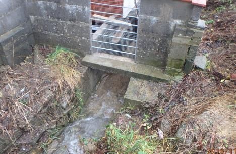
The third culvert identified as ‘Culvert 3’ is located 46m south west from Brook Street.
The culvert inlet conveys an unnamed ordinary watercourse beneath no 4 Gwawr
Street before out falling into the Nant Gwawr Watercourse opposite number 4 Gwawr
Street.
The source of the flooding was identified by local residents, first responder and officers
within the FRM team during the event as originating from an unnamed ordinary
watercourse that conveys behind Brook Street (Culvert 3). The surcharging occurred
at the inlet structure where the open channel enters into the concrete culvert system
through a 200mm rectangular inlet (Image 5); both the open channel and culvert
network at this location falls within private land ownership and is the responsibility of
riparian owners.
Page 14Flood and Water Management Act 2010
Section 19 Flood Investigation Report
October 2019
The inlet structure depicted by Image 5 identifies an ‘Obstruction’4 within the culvert
inlet which appears to restrict the inlet structures efficiency to convey the flow of the
watercourse.
Following the flood event the ripairan owner of Culvert 3 was approached in regards
to the maintenance of the inlet. No maintenance information was provided at the time
of the writing of this report. However, a statement that the channel is litter picked
regularly was stated. Based on the condition of the channel following the event;
maintenance is considered to be infrequent and does not form part of a routine
program.
Image 5: Post Event Photo – Depicts Culvert 3’s inlet structure provided by a local resident..
Images passed over to the LLFA by residents (Image 6 and 7) identified a pre and
post view of the inlet area where the channel is surcharged and in flood and the post
event condition which confirms the source of flooding recorded by the first responders
residents and FRM officers.
4 Land Drainage Act 1991 – Section 23 - https://www.legislation.gov.uk/ukpga/1991/59/section/23
Page 15Flood and Water Management Act 2010
Section 19 Flood Investigation Report
October 2019
Image 6: Post event Photo - Depicts Culvert 3’s Inlet area following the flooding event on the 13th
October 2019 provided by a local resident.
Image 7: Event Photo – Depicts the Culvert 3’s Inlet area during the Flood event on the 13th October
2019 provided by a local resident.
Page 16Flood and Water Management Act 2010
Section 19 Flood Investigation Report
October 2019
Following identification of the obstruction within the watercourse the Land Drainage
Authority reviewed its records associated to consent’s under section 23 of the Land
Drainage Act 1991 and identified that the modified structure did not have a consent.
Following which, an enforcement warning was issued under section 24 Land Drainage
Act that resulted in the owner removing the obstruction within the culvert inlet and
reinstating a 670mm opening (Image 8).
Image 8: Post event photo: Depicts Culvert 3 Inlet area following remedial work undertaken by the
riparian owner to reinstate an unobstructed flow.
Page 17Flood and Water Management Act 2010
Section 19 Flood Investigation Report
October 2019
3.2 OPEN WATERCOURSE CONDITIONS
On review of the open watercourse sections identified within the Aberaman area two
distinct networks were identified, the first is the Nant Gwawr watercourse that conveys
in a west to east orientation adjacent Gwawr Street (Culvert 1). This section of
watercourse was reviewed following the identification of movement in the adjacent
highway retaining wall.
A general inspection was undertaken, which recommended a more detailed analysis
of the structural integrity of the wall as a result of the number of structural defects
identified along the length of the watercourse. The Highway Authority commissioned
Redstart consultants to undertake an assessment of the highway retaining wall and to
design the necessary remedial works.
The work undertaken by Redstart included a review of the base level of the bed of the
Nant Gwawr at its current level and its effect on the structural integrity of the retaining
wall structure. The results of the investigation concluded that the current condition and
level of the bed of the Nant Gwawr should be retained to ensure the structural
performance of the retaining wall. The evidence suggested that lowering (dredging) of
the watercourse would be detrimental to the structural integrity of the retaining wall
and would serve no benefit to the conveyance of flow through the watercourse as it
would facilitate rapid siltation of natural riverine material.
The second open watercourse network is that of the unnamed watercourse that
conveys to the rear of Brook Street (Culvert 3) and continues from Culvert 2 Ross
Nathan Wyn towards the cycle path to the West of Brook Street where the network
conveys through a culvert structure from the upper catchment above.
The open watercourse channel was inspected following the Storm to ascertain
whether the channel conditions contributed to the flooding within Brook Street. The
inspection identified 5 sub sections within the channel depicted within Figure 4.
Page 18Flood and Water Management Act 2010
Section 19 Flood Investigation Report
October 2019
Figure 4: Channel Inspection Location Plan (Technical Note 1)
The summary within ‘technical note 1’ identified several sections between Area 2
– 4 where the channel and embankments have evidence of scour which is the
likely cause of the material deposited against the inlet of Culvert 2. It is of note that
Area 1 and 3 show signs of fly tipped material, which is more pronounced within
Area 3, which is likely to become mobilised during future high flow events.
Based on the level of debris in Area 2 compared to Area 1 it is considered that
Culvert 2 acted as barrier to the conveyance of sediment to the downstream
network, debris blockage as a result of upper channel scour is considered to be
an unlikely factor related to the flooding on the 13 th October.
Page 19Flood and Water Management Act 2010
Section 19 Flood Investigation Report
October 2019
3.3 ACCESS STRUCTURES
No access structures were identified during the asset investigations within the area,
as such ‘access structures’ have not been considered within this report.
3.4 SYSTEM AT CAPACITY
The evidence gathered post event has identified the source of flooding located at
Culvert 3. Following identification of the culvert inlet the network was surveyed to
ascertain the internal condition of the network (Figure 5), the result of which fed into a
review of the hydraulic performance of the network to ascertain the likely cause of
flooding.
Figure 5: Depicts the summary results of the Culvert Survey undertaken by the LLFA
Page 20Flood and Water Management Act 2010
Section 19 Flood Investigation Report
October 2019
‘Technical Note 2’ detailed the results of a ‘hydraulic model’ using ‘Micro drainage’5
software which represented the open channel section above Culvert 3 (Area 1) and
represented the structural condition of the network as it conveys through No 4 Gwawr
Street and enters into the Nant Gwawr.
The results from the hydraulic model identified that flooding would occur during a Q30
+30 climate change event with the obstructed inlet of the culvert 3 (assuming no
sediment accumulation within the network) (Image 5). ‘Technical note 2’ further
reviewed the interaction between the culvert network and the relative level of the Nant
Gwawr i.e. outlet control. The results identified that the culvert network was unaffected
by the bed level within the Nant Gwawr in its current condition (current bed level).
The model was also run with the post event condition of Culvert 3 inlet structure
following works undertaken by the resident to remove the obstruction within the
watercourse (Image 7). The results identified that the inlet and culvert network was
free from flooding up to and including the Q100 + 30% climate change event.
The results of the hydraulic model suggest that the flooding was a result of a structural
blockage erected within the inlet of Culvert 3 and that the Nant Gwawr had no
contribution to the flooding at Brook Street on the 13th October 2019. It further identified
that the works undertaken by the resident i.e. obstruction removal has improved the
standard of protection to Q100 +30% climate change.
5 Mico Drainage Software - https://www.innovyze.com/en-us/products/microdrainage
Page 21Flood and Water Management Act 2010
Section 19 Flood Investigation Report
October 2019
RIGHTS AND RESPONSIBILITIES OF RISK MANAGEMENT
AUTHORITIES
4.1 LEAD LOCAL FLOOD AUTHORITY
Within the Flood and Water Management Act 2010, Rhondda Cynon Taf County
Borough Council has been established as the Lead Local Flood Risk Authority (LLFA)
for its administrative area.
As defined in the Flood and Water Management Act 2010, RCT is responsible for
‘Managing’ what is termed, its ‘local flood risk’. This includes the risk of flooding from
ordinary watercourses, surface runoff and groundwater.
Local Authorities have always had certain responsibilities in relation to ordinary
watercourses, and in practice most Local Authorities took the lead in dealing with
surface water flooding incidents prior to the changes contained within the Flood and
Water Management 2010.
The Flood and Water Management Act 2010 places a number of statutory duties on
Local Authorities in their new role as LLFAs including:
1 - The preparation of local flood risk management strategies6
2 - A duty to comply with the National Strategy7
3 - To co-operate with other authorities, including sharing data
4 - A duty to investigate all flooding within its area, insofar as a LLFA consider
it necessary or appropriate
5 - A duty to maintain a register of structures and features likely to affect flood
risk;
6 - A duty to contribute to sustainable development; and
7 - Consenting powers on ordinary watercourses.
In addition to these each LLFA has a number of what are called permissive powers.
These are powers that allow them to do something, but do not compel them to and
include:
1 - Powers to request information;
2 - Powers to designate certain structures or features that affect flood or
coastal erosion risk;
3 - The expansion of powers to undertake works to include broader risk
management actions; and
6 RCT Local Flood Risk Management Strategy -
https://www.rctcbc.gov.uk/EN/Resident/ParkingRoadsandTravel/Roadspavementsandpaths/FloodAlleviation/Loc
alFloodRiskManagementStrategy.aspx
7 WG National Strategy for Flood and Coastal Erosion Risk Management - https://gov.wales/flood-and-coastal-
erosion-risk-management-strategy
Page 22Flood and Water Management Act 2010
Section 19 Flood Investigation Report
October 2019
4 - The ability to cause flooding or coastal erosion under certain conditions.
LLFA’s in Wales also take on the role of the SuDS Adopting and Approving Body in
relation to sustainable drainage systems as of the 7th January 2019. In this role they
will be responsible for both approving the original design of the SuDS and adopting
and maintaining the finished system in accordance with the Welsh Governments
National Standards for Sustainable Drainage.
The function of the LLFA during and after the flooding at Brook Street included a range
of Response and Recovery functions:
Officers investigated the initial flooding and have produced this report in line
with section 19 FWMA 2010.
Officers contacted residents affected by flooding to offer support and advice to
assist in the recovery following the event.
Officers coordinated the response of the flooding with the South Wales Fire and
Rescue Service.
Asset information collected during the flood event has been incorporated into
the LLFA Asset Register.
Following the results into the investigation of flooding at Brook Street both the LLFA
and LDA do not intend to exercise any additional functions following the flooding event,
however, the LLFA and LDA will continue to work with residents in managing the local
flood risk.
Page 23Flood and Water Management Act 2010
Section 19 Flood Investigation Report
October 2019
4.1 NATURAL RESOURCES WALES
Historically the Environment Agency (precursor to Natural Resources Wales) led on
the management of the risks of flooding from main rivers and the sea. However, as a
consequence of the Flood and Water Management Act 2010 certain changes have
been made to their role and remit. In addition to flooding from rivers and the sea,
Natural Resources Wales has new operational responsibilities in relation to coastal
erosion and a wider oversight role for all flood and coastal erosion risk management
in Wales.
This change means that Natural Resources Wales has a dual role: -
1. Operational responsibilities for flooding from main rivers, the sea and coastal
erosion.
2. Oversight responsibilities in relation to all flood and coastal erosion risk
management in Wales.
The oversight change is integral to the delivery of national policy on flooding and
coastal erosion risk management and has been taken forward to ensure that Natural
Resources Wales has the remit to support the Welsh Government across the full range
of flood and coastal erosion risks affecting Wales.
As part of their oversight role, Natural Resources Wales will lead on the provision of
technical advice and support to other Risk Management Authorities. They will also
lead on national initiatives such as Flood Awareness Wales, the national raising
awareness program, and be the single point of contact for enquiries and information
on flood risk, currently being piloted via their new Flood Line warning service8.
The Flood and Water Management Act 2010 places a number of statutory duties on
Natural Resources Wales including:
a) Co-operating with other authorities, including sharing data;
b) Reporting to the Minister on flood and coastal erosion risk in Wales including the
application of the National Strategy; and
c) The establishment of Regional Flood and Coastal Committees.
8 NRW Flood line Warning - https://naturalresources.wales/flooding/sign-up-to-receive-flood-warnings/?lang=en
Page 24Flood and Water Management Act 2010
Section 19 Flood Investigation Report
October 2019
In addition to their statutory duties, Natural Resources Wales has a number of
permissive powers. These are powers that allow them to do something, but do not
compel them to and include:
a. Powers to request information
b. The ability to raise levies for local flood risk management works, via the
Regional Flood and Coastal Committees
c. Powers to designate certain structures or features that affect flood or
coastal erosion risk
d. The expansion of powers to undertake works to include broader risk
management actions; and
e. The ability to cause flooding or coastal erosion under certain conditions.
This new allocation of responsibilities is also consistent with Natural Resources Wales’
role; in relation to the Flood Risk Regulations 2009. Which allocates specific
responsibility for conducting assessments in relation to mapping and planning the risks
of flooding from main rivers, the sea and reservoirs to Natural Resources Wales, as
well as providing guidance to Local Authorities on these matters for flooding from other
sources.
Under the Regulations, Natural Resources Wales also takes on an assessment and
coordination role at a national level, ensuring the correct information is passed back
to the European Commission.
Natural Resources Wales were not identified as a responsible authority in relation to
the flooding at Brook Street on the 13th October 2019. Furthermore, the authority does
not propose to undertake any functions in relation to the event.
Page 25Flood and Water Management Act 2010
Section 19 Flood Investigation Report
October 2019
4.2 WATER COMPANY
Water companies, when exercising their flood or coastal erosion risk management
functions in relation to an area within Wales, must have regard to the relevant Local
Strategies and any associated guidance.
Water and sewerage companies are responsible not only for the provision of water,
but also for making appropriate arrangements for the drainage of foul water, the
treatment of waste, surface water sewers and combined sewers. They have primary
responsibility for floods from water and sewerage systems, which can include sewer
flooding, burst pipes or water mains or floods caused by system failures.
No changes have been made to the operational arrangements for water and sewerage
companies in respect of flood risk.
The Flood and Water Management Act 2010 places a number of statutory duties on
Water and Sewerage Companies including:
1 - A duty to act consistently with the National Strategy;
2 - A duty to have regard to the content of the relevant Local Strategy; and
3 - Co-operation with other Authorities, including sharing data.
Water and sewerage companies often hold valuable information, which could greatly
aid the understanding of flood risks faced by communities across Wales .
Welsh Water were not identified as a responsible authority in relation to the flooding
at Brook Street on the 13th October 2019. Furthermore, the authority does not propose
to undertake any functions in relation to the event.
Page 26Flood and Water Management Act 2010
Section 19 Flood Investigation Report
October 2019
5 ROLE OF OTHER AUTHORITIES
5.1 NETWORK RAIL
Network Rail has an operational responsibility as a riparian owner and is required to
undertake regular maintenance of all assets that pose a risk to flooding. Regarding
this investigation, no infrastructure within the responsibility of network rail was
identified to cause or contribute to the residential flooding at Brook Street.
5.2 HIGHWAY AUTHORITY
The highway authority is responsible for ensuring the highway is clear of obstructions
and has a drainage system that controls the surface water that enters onto the
highway.
During the Investigation into the Flood at Brook Street the Highway was identified as
flooding as a result of the influx of flood waters through the properties and onto the
Highway resulting in Highway Flooding, however, the highway drainage apparatus
eventually managed the additional overland flows once the rainfall had subsided.
Following the initial flooding event the Highway Authority arranged for the highway
drainage gullies to be inspected and cleansed following the influx of flood waters to
ensure the safety of the highway post event.
5.3 RIPARIAN LANDOWNERS
Riparian Landowners are legally responsible under common law for the maintenance
of the land generally up to the centerline of any watercourse adjacent to their property.
This includes the maintenance of the bed, banks and any boundary features e.g.
vegetated strips such as hedging, with routine clearance of debris and/or blockages.
This does not mean that the owner must remove all debris from the watercourse, but
it does require the owner to maintain as far as it does not pose a risk or ‘nuisance’ to
a neighbour. Any works to modify the watercourse by the landowner must first be
passed through the relevant Risk Management Authority, Lead Local Flood Authority
(LLFA) or Natural Resources Wales (NRW).
The evidence gathered in support of this report suggests that the flooding attributed to
Brook Street originating from the ownership of a riparian owned watercourse, which
does not benefit from a defined maintenance program undertaken by the riparian
owners. Under common law, Riparian Owners have rights and responsibilities relating
Page 27Flood and Water Management Act 2010
Section 19 Flood Investigation Report
October 2019
to any watercourse that passes through or adjacent to the boundaries of their land.
This means that the landowner must:
Pass on flow without obstruction, pollution or diversion affecting the rights of
others.
Accept natural flood flows through their land, even if caused by inadequate
capacity downstream, as there is no common law duty to improve a
watercourse.
Maintain the bed and banks of the watercourse (including trees and shrubs
growing on the banks) and clear any debris, natural or otherwise
Not cause any obstructions to the free passage of fish.
Keep the bed and banks clear from any matter that could cause an
obstruction either on their land, or by being washed away by high flow to
obstruct a structure downstream.
Take responsibility for protecting their property from seepage through natural
or constructed banks.
Keep clear any structure that they own such as culverts, trash screens, weirs
etc.
Under the FWMA 2010, a landowner needs consent from the Land Drainage Authority
if they want to construct a culvert or flood relief control structure on any ordinary
watercourse.
5.4 RESIDENTS
Residents and property owners are responsible for the protection of their own
properties against flooding. Residents have the right to defend their property as long
as they do not subsequently increase the risk of flooding to other properties.
Page 28Flood and Water Management Act 2010
Section 19 Flood Investigation Report
October 2019
PERMISSIVE POWERS OF RISK MANAGEMENT
AUTHORITIES
Risk Management Authorities have direct permissive powers under the Flood and
Water Management Act 2010, as well as the Land Drainage Act 1991. Through the
investigation of the flooding, that impacted Brook Street the use of Permissive powers
of risk management authorities was recorded.
The Results identified that the Land Drainage Authority (RCTCBC), on being made
aware of an Obstruction (Culvert 3); reviewed the Consenting records and found no
consent was issued for the structure within the Inlet of Culvert 3. Following which a
warning letter was issued to the Riparian Land owner of the culvert inlet on 25th
October 2018 requiring the nuisance to be abated within 14 days.
Following receipt of the warning letter the resident undertook works to remove the
obstruction from the channel of the watercourse complying with the warning on the
29th October 2018.
Page 29Flood and Water Management Act 2010
Section 19 Flood Investigation Report
October 2019
CONCLUSION
This report has detailed the investigation into the Flooding at Brook Street, Aberaman
during Storm Callum; 13th October 2018. The investigation has reviewed evidence
provided by Responders, Residents and Investigating officers and has been supported
through the production of technical notes.
The impact of the storm resulted in widespread internal property and commercial
flooding throughout RCT with transport links being affected by both Pluvial and Fluvial
sources.
The storm was identified as ‘Storm Callum’ by the ‘Met Office’ and represented an un-
predictable storm cell that resulted in 7 weather warnings being issued by the Met
Office ranging from Yellow to Amber warnings with rainfall predictions increasing
closer to the 12th – 13th October. Local rainfall gauges operated within RCT identified
high total rainfall levels 136.6mm and 160mm in the Northern half of the borough with
peak intensities reaching 12mm per hour. The result of which identified highest
recorded readings at three NRW river monitoring stations.
The event reports identified that the source of the flooding originated from Culvert 3
located west of Brook Street which identified a 200mm rectangular inlet (Image 5). The
flow path of the flood water entered the rear gardens of Brook Street and internally
flooded 4 properties and flooded the Highway of Brook Street.
The review of the Culvert 3 identified an ‘Un-consented structure’ within the culvert
inlet. On becoming aware of the ‘un-consented structure’ the Land Drainage Authority
issued a warning to the riparian owner requiring the ‘Nuisance’ to be removed; which
was complied with by the riparian owner within 4 days of issuing the warning.
In review of the flooding event the hydraulic performance of Culvert 3’s network was
undertaken. The results identified that Culvert 3 with the obstruction present (Image
5) would flood during a Q30 + 30% Climate Change event. When compared to Culvert
3 as with the obstruction removed (Image 8) the inlet was found to flood above Q100
+ 30% which represents current design standards for new culverts.
The Culvert network was further tested to verify the interconnectivity of Culvert 3 and
that of the Nant Gwawr. The result of which suggest that the Nant Gwawr watercourse
(Including bed level) had no influence on the performance of the Culvert 3.
The evidence gathered within this report demonstrates that the cause of the internal
flooding at Brook Street on the 13th October 2019 was a result of an un-consented
structure being erected by the riparian owner of Culvert 3.
Page 30Flood and Water Management Act 2010
Section 19 Flood Investigation Report
October 2019
The investigation has noted however, that the un-consented structure was removed;
by the riparian owner following a warning letter issued by the Land Drainage Authority
(RCT).
Page 31Flood and Water Management Act 2010
Section 19 Flood Investigation Report
October 2019
USEFUL LINKS/CONTACTS
Blue Pages – property Resilience - http://bluepages.org.uk/
Flood Re – Flooded Property Insurance Scheme - https://www.floodre.co.uk/
Natural Resources Wales – Check Flood Warnings -
https://naturalresources.wales/flooding/check-flood-warnings/?lang=en
Natural Resources Wales - Long Term Flood Risk -
https://naturalresources.wales/evidence-and-data/maps/long-term-flood-
risk/?lang=en
Rhondda Cynon Taf CBC - Local Flood Risk Management Plan -
https://www.rctcbc.gov.uk/EN/Resident/ParkingRoadsandTravel/Roadspavementsan
dpaths/FloodAlleviation/Floodriskregulations2009.aspx
Rhondda Cynon Taf CBC - Local Flood Risk Management Strategy -
https://www.rctcbc.gov.uk/EN/Resident/ParkingRoadsandTravel/Roadspavementsan
dpaths/FloodAlleviation/LocalFloodRiskManagementStrategy.aspx
Rhondda Cynon Taf CBC – Sustainable Drainage –
https://www.rctcbc.gov.uk/EN/Resident/ParkingRoadsandTravel/Roadspavementsan
dpaths/SustainableDrainage/SustainableDrainage.aspx
Welsh Government - National Strategy for Flood and Coastal Erosion Risk
Management - https://gov.wales/sites/default/files/publications/2019-03/national-
strategy-for-flood-and-coastal-erosion-risk-management-in-wales.pdf
Welsh Water – How to Contact Us – https://www.welshwater.com/en/Contact-
Us.aspx
Page 32You can also read