N11/N25 Oilgate to Rosslare Harbour - Constraints and Option Selection Public Consultation July 2020
←
→
Page content transcription
If your browser does not render page correctly, please read the page content below
N11/N25 Oilgate to
Rosslare Harbour
Constraints and Option Selection
Public Consultation
July 2020
N11/N25 Oilgate to Rosslare Harbour l Constraints and Option Selection l Public Consultation July 2020

Introduction                                                         Objectives Of The Scheme
Wexford County Council is working in association with                ● 		   Improve the efficiency and capacity of the N11
Transport Infrastructure Ireland (TII) to develop an                 		     and the N25 within the study area.
approximate 30km section of high quality road which                  ● 		   Reduce the frequency and severity of collisions
will link Rosslare Europort/Wexford with both Dublin                 		     and casualties on the N11 and N25 within the
via the M11 and Cork / Waterford via the N25.                        		     study area.
                                                                     ● 		   Reducing journey time.
The M11 Gorey to Enniscorthy motorway was opened
                                                                     ● 		   Improving journey time reliability.
to traffic in July 2019, and this current project is
studying the existing N11 to the south of this motorway,
                                                                     Constraints Study
on to Wexford, as well as the connecting N25 road
from Wexford to Rosslare Harbour. These routes                       In identifying the preliminary scheme options, a
form part of the European Designated E01 Route and                   Constraints Study was undertaken. The purpose of
provide a direct link to both mainland Europe and                    the Constraints Study is to identify and present all the
the United Kingdom via Rosslare Europort. Rosslare                   characteristics and features of the study area, whether
Europort is the State’s second largest passenger                     natural, artificial or external, which may influence the
port, and the fourth largest port in terms of overall                identification of viable scheme options. The Study
tonnage. Significant growth is forecast in the coming                Area within which key constraints and preliminary
years which will further increase the Port’s strategic               scheme options were examined is shown on the map
importance for trade, business and tourism, bringing                 included in this brochure.
economic benefits not just to Wexford, but across the
South East region and nationally. Maintaining and
enhancing the requirements to directly access EU
ports, as well as access to UK ports post Brexit, will
assist in building a resilient trade link with Ireland’s EU
partner states, no matter what the impact of EU and
UK trade negotiations.

This is a strategically important part of the national
transport network and the project aims to ensure
that the sections of the network in question have
the capacity and resilience to safely meet the future                The main physical, engineering and environmental
transport needs on a national, regional and local level.             constraints identified within the study area are as
                                                                     follows:
Wexford County Council have appointed Mott                           ● 		 Ecological conservation sites of interest such as
MacDonald Ireland Limited to advance the project                     		 Forth Mountain pNHA, Slaney River Valley SAC
through the planning and design process and
                                                                     		 and Wexford Slobs and Harbour SPA and pNHA.
Tramore House Regional Design Office is providing
                                                                     ● 		 Sites of Archaeological and Architectural
project management services for the Council. The
                                                                     		significance.
planning and design process will develop in phases,
                                                                     ● 		 Locations and patterns of residential housing and
the project team are now consulting with the public,
and in particular the residents of the study area, on                		 other properties.
the options identified that could meet the project                   ● 		 The Dublin to Rosslare railway line.

objectives, in order to help determine the preferred                 ● 		 Topographical and Geological areas such as the

scheme option.                                                       		 River Slaney and Forth Mountain.
                                                                     ● 		 Existing Utilities.

                                                                     A series of maps showing the identified constraints
                                                                     are available on the project website and the public
                                                                     are now invited to provide feedback on the identified
                                                                     constraints. These constraints have been considered
                                                                     carefully by the project team and have helped to
                                                                     identify the preliminary scheme options that are now
                                                                     presented. This public consultation is an integral part
                                                                     of the study of constraints and preliminary scheme
                                                                     options. It helps the project team access local
                                                                     knowledge and identify areas of concern, which are
                                                                     then taken into consideration in the development and
                                                                     assessment of scheme options and the future planning
                                                                     of the project.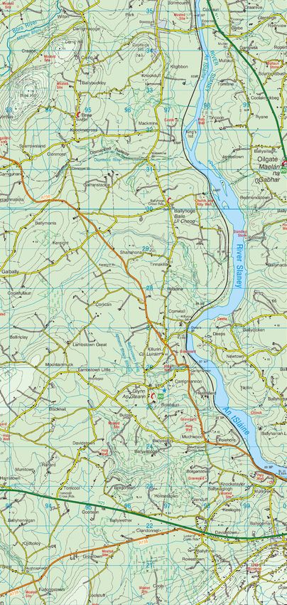
N11/N25 Oilgate to Rosslare Harbour l Constraints and Option Selection l Public Consultation July 2020
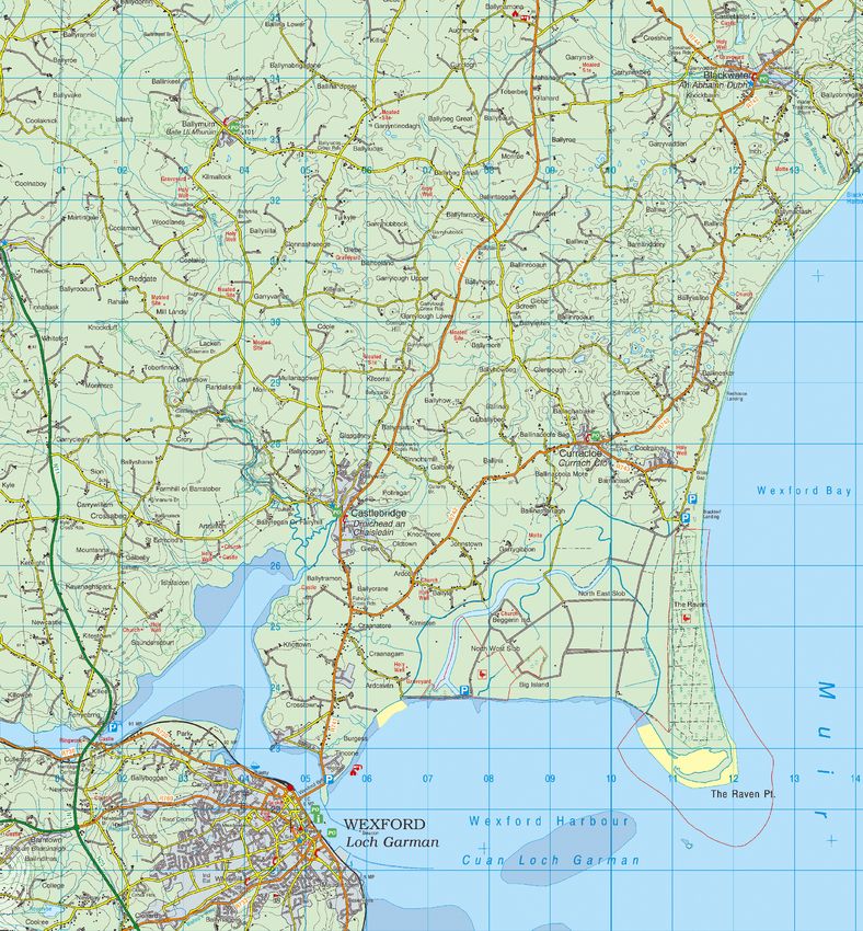
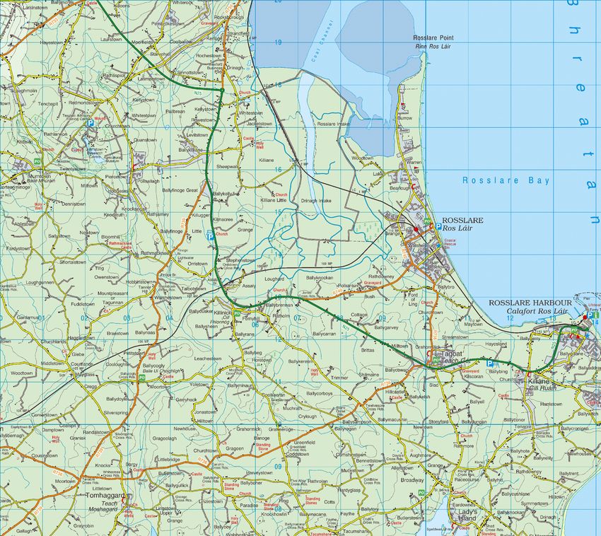
SOURCE: Reproduced from Ordnance Survey digital map
data. All rights reserved.
Licence number: 2020/34/CCMA/WexfordCountyCouncil Legend :
Study Area Boundary
Scurlocksbush Roundabout M11 Gorey to Enniscorthy Motorway
Option A - Purple Route
Option B1 - Green Route - Existing Road Corridor "Do Minimum"
Option B2 - Green Route - Existing Road Corridor "Management Option"
King's Island Option C - Orange Route
Option D - Blue Route
Oilgate Option E - Pink Route
Option F - Yellow Route
Option G - Brown Route
N1
1
Deep's Bridge
Kyle Cross Roads
i
C
D A
B
F E Ferrycarrig
G
Larkin's Cross Roads
Barntown Wexford
ii
Forth Mountain
Rosslare
iii
Stephenstown
iv Ashfield Cross Roads
Rosslare Harbour
v vi
Killinick
Tagoat
N25 Rosslare Europort Access Road - This project is
also currently at option selection stage. The
interface between the scheme options for the
separate projects will be informed by the outcomes
of the separate option selection processes
Notes
1. DO NOT SCALE, use figured dimensions only. All dimensions to be checked on site.
2. All levels are referred to Ordnance Survey Datum, Malin Head.
3. Drawings co-ordinates are at Irish Grid
4. This drawing to be read in conjunction with all relevant works requirements specifications and drawings.
Mott MacDonald
This Document is issued for the party which commissioned it and for specific purposes connected with the captioned project only. It should not be relied upon by any other party or used for any other purpose.
We accept no responsibility for the consequences of this document being relied upon by any other party, or being used for any other purpose, or containing any error or omission which is due to an error or omission in data supplied to us by other parties.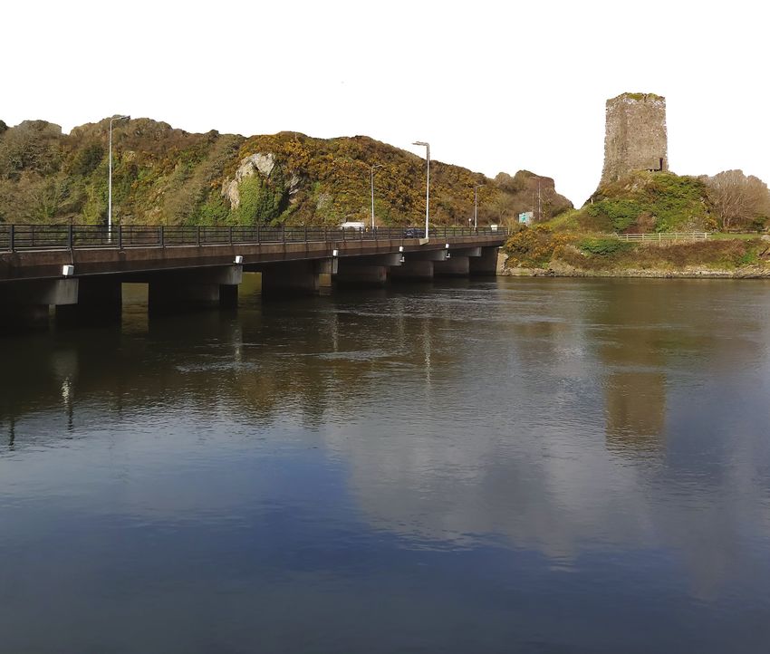
N11/N25 Oilgate to Rosslare Harbour l Constraints and Option Selection l Public Consultation July 2020

Option Descriptions                                                  of the existing N25 and then west of Stephenstown,
                                                                     passing south of Killinick and Tagoat ending at Rosslare
Option A                                                             Harbour.
Option A begins at the southern end of the M11 Gorey
to Enniscorthy Scheme and passes east of Oilgate                     Option E
continuing east of the existing N11 crossing the River               Option E begins at the southern end of the M11 Gorey
Slaney at or near the existing Ferrycarrig Bridge. From              to Enniscorthy Scheme and passes west of Oilgate
here the option follows the existing N11 and the N25                 continuing west of the existing N11 before crossing
(along the existing Wexford Ring Road) before passing                the River Slaney south of Deep’s Bridge. The option
southwest of the existing Rosslare Road Roundabout.                  swings southeast then east, parallel to the River Slaney
It then passes Stephenstown running east of the                      and continues south crossing the N25 to the east of
existing N25 and continues east running north of                     Barntown and west of the N11/N25 roundabout. From
Tagoat before ending at Rosslare Harbour.                            here the option follows the same corridor as Option
                                                                     D, continuing west of the existing N25 and then west
Option B                                                             of Stephenstown passing south of Killinick and Tagoat
Option B begins at the Scurlocksbush Roundabout and                  before ending at Rosslare Harbour.
follows the existing N11 and N25 corridors through the
study area to Rosslare Harbour. There are two options                Option F
along this option corridor.                                          Option F begins at the southern end of the M11 Gorey
                                                                     to Enniscorthy Scheme and then follows the same
Option B1                                                            corridor as Option E to the west of Oilgate continuing
This “Do-Minimum” option utilises the existing N11                   west of the existing N11 before crossing the River Slaney
and N25 National Roads. This option only considers                   south of Deep’s Bridge. The option then diverges
future improvement works along the existing road                     from Option E and continues southwest crossing the
corridor that are already planned and committed (e.g.                N25 west of Larkin’s Cross Roads. It continues south
N25 Ballygillane Roundabout at Rosslare Harbour) and                 passing west of Forth Mountain before joining Options
routine investment in the maintenance and operation                  D and E to the west of Stephenstown and continuing
of the current road corridor.                                        south of Killinick and Tagoat before ending at Rosslare
                                                                     Harbour.
Option B2
This “Management Option” assumes that there will                     Option G
be investment to improve the existing N11 and N25                    Option G begins at the southern end of the M11 Gorey
National Road corridors. This option seeks to utilise                to Enniscorthy Scheme and passes west of Oilgate
the existing asset where feasible through a package                  and the existing N11 before crossing the River Slaney
of on-line improvements which may include a mix of                   to the south of Kings Island. It continues south passing
the following: the rationalisation of junctions and direct           west of the River Slaney and crossing the existing
accesses onto the N25, provision of parallel service                 N25 west of Larkin’s Cross Roads. It continues south
roads, left-in/left-out junctions, separated pedestrian              where it joins Option F passing west of Forth Mountain
and cyclist facilities, designated vehicle lanes etc.                before also joining Options D and E to the west of
                                                                     Stephenstown and continuing south of Killinick and
Option C                                                             Tagoat ending at Rosslare Harbour.
Option C begins at the southern end of the M11 Gorey to
Enniscorthy Scheme and passes east of Oilgate before                 Possible Option Combinations
joining the existing N11 south of Oilgate and follows                Further scheme options are possible utilising the cross
the existing N11 before crossing the River Slaney west               over options shown in dotted Grey and marked with
of Ferrycarrig Bridge. From here the option follows the              roman numerals.
same corridor as Option A, following the existing N11
and the N25 (along the existing Wexford Ring Road)                   Disclaimer Note:
before passing southwest of the existing Rosslare                    The scheme options shown are indicative and are
Road Roundabout. It then passes Stephenstown and
                                                                     illustrated for the purpose of obtaining comments and
continues east running north of Tagoat and ends at
Rosslare Harbour.
                                                                     feedback as part of the public consultation process.
                                                                     The options shown may therefore be subject to some
Option D                                                             changes arising from the consultation process and
Option D begins at the southern end of the M11 Gorey                 subsequent assessment. Any scheme options that are
to Enniscorthy Scheme and passes east of Oilgate                     developed will be subject to evaluation and assessment
before crossing the existing N11 south of Oilgate. It                before the preferred scheme option is identified and
continues to the west of the existing N11 crossing the
                                                                     will be further developed through subsequent design
River Slaney west of Ferrycarrig Bridge. The option
                                                                     and planning stages.
continues south passing east of Barntown and west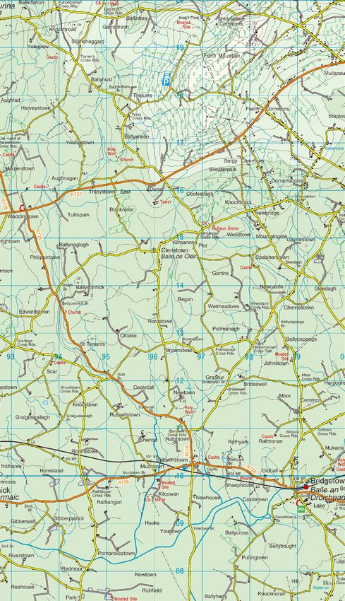
N11/N25 Oilgate to Rosslare Harbour l Constraints and Option Selection l Public Consultation July 2020

What Happens Next (indicative timescale)

   Constraints &                   Option                    Preferred                   Design &          Statutory
  Option Selection                Selection                    Route                  Environmental       Procedures
       Public                      Report                    Corridor                   Evaluation
   Consultation
       2020                         2020                        2021                        2022             2023

Your Views Are Important                                             the project website. This report will summarise the
                                                                     consultation process and the matters raised during the
The project team are now engaging with the public on                 consultation.
the finding of the constraints study and the preliminary
scheme options that have been identified. At this                    Should you wish to contact the project team by
stage of the project a public consultation event would               telephone the following phone number is available:
normally be arranged to provide an opportunity for                   053 9196000.
public participation at this early stage in the project’s
development.                                                         To allow the project team to review and consider
                                                                     your query fully, we would ask that email or phone
However in accordance with current Covid-19 guidance,                queries are submitted before 4pm on Tuesday 7th
and in order to protect the public and project staff from            July 2020. Phone calls will be answered by a member
the risk of the transmission, it is not possible to hold             of our customer services team and you will be asked
a public event at this time. Instead we are holding an               to provide your name, phone number and a brief
online public consultation event on the project website              description of your query. Arrangements will then be
http://oilgate2rosslareharbour.ie/                                   made for a member of the project team to call you
                                                                     back and discuss your query within 48 hours.
This online consultation will commence on Monday
6th July until Monday 20th July 2020.
                                                                     Further Enquires
The website will provide you with the most up to date
                                                                     All queries, questionnaires or comments in relation
information on the project, including:
                                                                     to the project may be addressed to:
● 		 This Public Consultation Brochure.
● 		 A series of maps showing the study area and
                                                                      N11/N25 Oilgate to Rosslare Harbour Scheme
		 the identified constraints within the study area.
● 		 A map showing the preliminary scheme options.
                                                                      Wexford County Council, Carricklawn, Wexford,
● 		 An online feedback form (same format as the
                                                                      Y35 WY93, Ireland.
		 accompanying form).                                                Email: customerservice@wexfordcoco.ie
● 		 A list of Frequently Asked Questions focusing on                 Phone: 053 9196000
		 the Option Selection process.                                      Website: www.oilgate2rosslareharbour.ie/contact-us

Your Views Are Important
Wexford County Council wishes to consider all
viewpoints during this option selection process.
Your comments and queries can be submitted online
via the website feedback form or via an email to
customerservice@wexfordcoco.ie

In order to ensure the most inclusive engagement with
the public, we are inviting those who may have limited
online accessibility to fill out the accompanying form
and return it by Freepost (no envelope needed, just
fold and seal the form).

Feedback forms may be submitted online or by
Freepost until Monday 20th July 2020. All feedback
received will be considered by the project team and
a Post-Consultation Report will be published on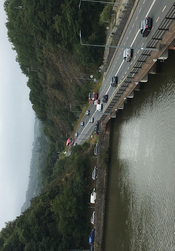


You can also read