NAO North and central Andean subduction international
←
→
Page content transcription
If your browser does not render page correctly, please read the page content below
NAO
North and central Andean subduction international
                   Observatory

From physical processes to social, environmental and
    development impacts of large earthquakes

                          Charvis P., IRD, Géoazur

   This project intends to be a federative, transdisciplinary and international
     project for the observation, the modeling, the quantification and the
          mitigation of natural hazards and their impacts on societies.

                                30 k€ 2017-2018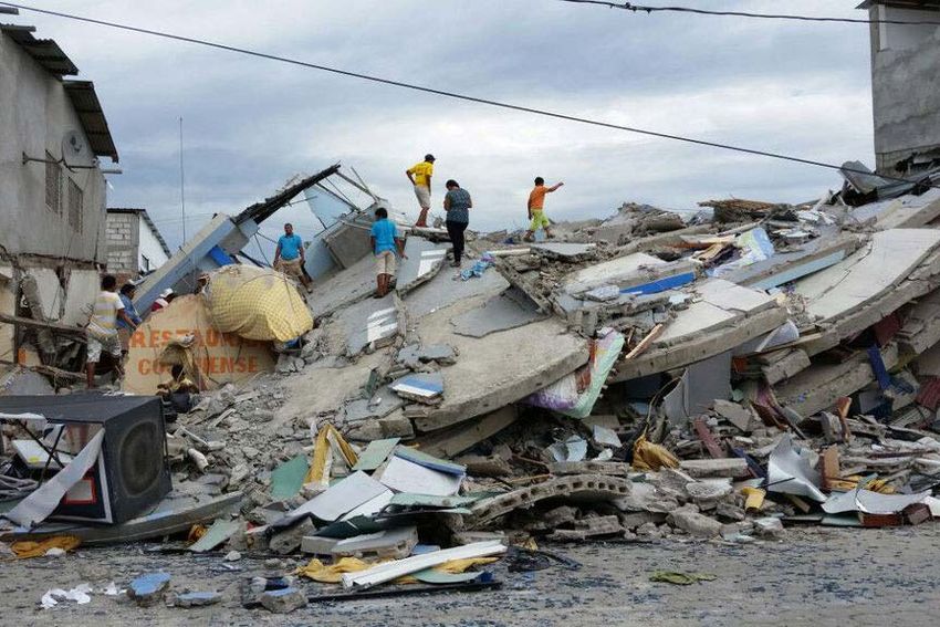
Why study the Andean subduction zone ?
                                               •   Subduction zones are among the areas with
Large earthquakes are along subduction zones       the highest natural hazards including large
                                                   earthquakes, volcanic eruptions, tsunamis,
                                                   landslides
                                               •    These coastal areas are densely populated
                                                    with the development of huge and
                                                    vulnerable cities (several millions of people
                                                    are living in Santiago, Lima or Guayaquil) and
                                                    vital infrastructures.
                                               •    Many of the countries along the Andean
                                                    margin of South America are developing
                                                    economies according to the International
                                                    Monetary Fund (Chile, Peru and Ecuador)
                                               •    These fragile economies are sensitive to the
                                                    effects of natural hazards.
                                               •    It is our responsibility to help these countries
                                                    to build safe and resilient societies.
                                               •    This can furthermore teach us how to build
                                                    our safe cities in our regions where hazards
                                                    are lower yet well existing.
2016 Ecuador earthquake >600 dead - >$3.3B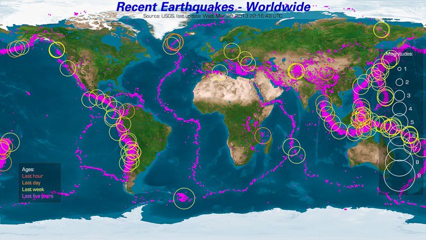
Project Objectives
• 1- Observation of deformation at
subduction zones based on innovative in
situ onshore and offshore observation
instrument systems.
– This is partly supported by ANR REMAKE
Seismic Risk in Ecuador : Mitigation,
Anticipation and Knowledge of
Earthquakes
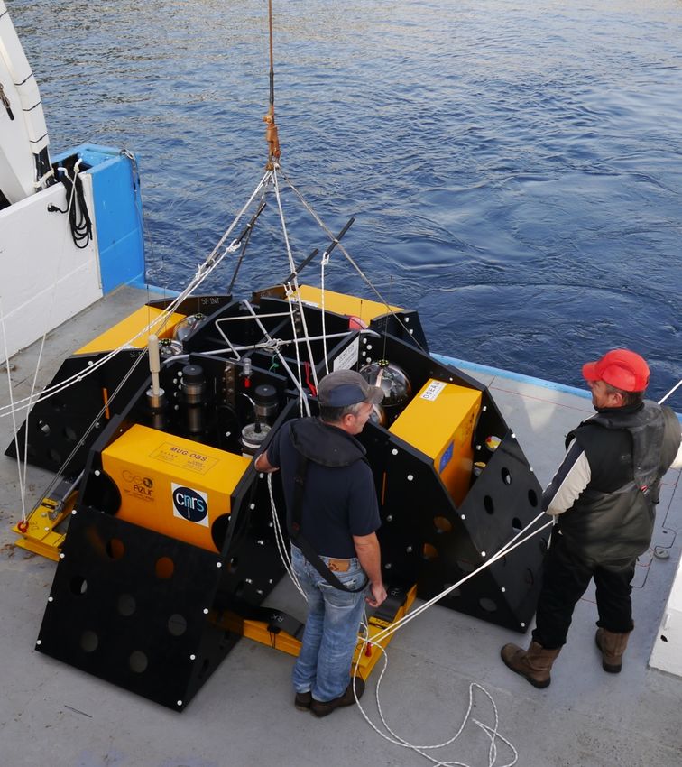
– Deployment of ~80 sensors (seismometers
and GPS) after the 2016 Pedernales
earthquake in Ecuador
– Proposal (H2020 ?) to develop and deploy
innovative submarine sensors to measure
sea bottom deformation
– A multidisciplinary database of acoustic
and seismic signals including various
environmental signals (biology,
meteorology, etc) will be provided. 3 years autonomy ocean bottom station
Project Objectives
  •   2- Modeling of rupture processes at subduction zone the keys that will permit to understand
      these rupture processes
       –   imaging large earthquakes across a 3D Earth at high resolution,
       –   producing generic models of dynamic rupture,
       –   modeling the seismic cycle (repeating earthquakes) including transient phenomena,
       –   taking into account actual fault source properties to produce realistic models of ground motions

       –   The acquired seismological and geological knowledge will allow the anticipation of the location, size,
           frequency, ground motions of future destructive events and the computation of natural hazard maps,
           a useful tool for territory planning.
  •   3- Evaluation and mitigation of the impacts of natural hazards implies to be prepared before
      the next event to reduce the human, environmental and financial consequences
       –   disaster risk assessment (vulnerability assessment, to get or build more resilient cities),
       –   evolution of urban structures during reconstruction,
       –   human rights and natural disasters (unequal access to assistance, discrimination in aid provision,
           displacement, etc), numerical simulation of individual behavior and interaction between agents for
           crisis management.

Objective 3 is the most challenging because it requires physicists
To work with geographers, economists, etc
Partners
• Involved UCA-Labs: GEOAZUR, LJAD, CEMEF, INRIA-SAM, ESPACE, GREDEG, SKEMA
• Other French partners: CEREMA, IFSTTAR, ENS Paris, CRIDEAU LIMOGES, etc
• Latin America partners: IG-EPN (Instituto Geofísico, La Escuela Politécnica
Nacional) Quito Ecuador, INOCAR (Instituto Oceanográfico de la Armada)
Guayaquil Ecuador, ESPOL (Escuela Superior Politécnica del Litoral) Guayaquil
Ecuador, Distrito Metropolitano de Quito
• IGP (Instituto Geofísico del Perú), DHN (Dirección de Hidrografía y Navegación
Marina del Perú)
• SGC (Servicio Geológico Colombiano)
• Universidad de Chile (Santiago), INRIA Chile and CIRIC (Communication and
Information Research and Innovation Center)
• Other international partners: Seismological Laboratory at California Institute of
Technology (J.P. Ampuero), ETH Zürich (M. Boese, J. Clinton), University of Pise (G.
Molli)
• International organizations: CEPAL (Comisión Económica para América Latina,
United Nations)
• UNASUR (Unión de Naciones Suramericanas)This organization had been suggested in 2016 to envision how the two large proposals “NAO”
and “Risks in our Territory” could possibly interact, grow and eventually transform UCA
Fed by other “external” data worldwide
NAO1 Natural & Anthropic
• Anticipation of Generic, Risks on our territory
forthcoming EQs Innovative innovative • Knowledge &
(location, size, time) Identification and anticipation of
• Anticipation of
instruments approaches current &
Earthquake physics mapping of the various
Ground Motions hazard “sources” on our forthcoming
• EQ2 models hazards
Physics of inter- • Models of EQ territory: telluric, other
• Anticipation of
forthcoming connected hazards “cycles” natural, anthropic • Estimating risks
tsunamis & landslides (tsunami, landslides, volcanoes) • Models of GM3 on our societies,
Monitoring “sources” of environments,
most threatening hazards especially
• Building response & Estimating impacts on • Models of inter- coastline,
vulnerability (focus on coast)
cities connected economy,
hazards Producing models of industries, etc.
• From individual to
collective behaviors Estimating impacts on • Models to hazards, single & inter-
• Helping
& consequences human beings & societies quantify risks & connected, to anticipate stakeholders &
(local to worldwide) uncertainties their impacts on our decision-makers
Estimating impacts on environments, societies, to manage the
• From landscape environments • Approaches for industries, tourism, risks
changes to worldwide Early Warning economy, etc. • Helping
consequences
Communication, education, industries to best
Developing approaches
• To build safe and Hazardmanagement adapt to current
smart cities to increase resilience & & future risks
restore environments
Transferring data & • Building the
• NAO, an international
Observatory results to international Communication, education, smart cities of
hazard management the future
Contributing to new • Expanding to
(1) North Andean Subduction Observatory
(2) Earthquake
Transposition environmental laws
Mediterranean
basin
(3) Ground MotionsCurrent year statement • Jean-Paul Ampuero : Professor of Seismology at the California Institute of Technology will be hired as Directeur de recherche IRD at Géoazur – an academic chair will be supported by UCA in frame its international action in South America • Next september we organize a workshop entitled “Interdisciplinarity / Transdisciplinarity : from announcement to implementation – the example of the geo-hazards in the Andes”
Interdisciplinarity / Transdisciplinarity : from announcement to
implementation – the example of the geo-hazards in the Andes

• Identification of obstacles and gains to a transdisciplinary approach
  of risks
• Preliminary list of invited participants
    – Julien Rebotier (CNRS) and Patrick Pigeon (Univ. Savoie) : Disaster
      Prevention Policies
    – Virginia Garcia-Acosta : anthropology and history of risk assessment in
      Mexico
    – Juanita Lopez (Disaster Risk Management and Climate Change) the use
      of DesInventar database to prevent desasters in Colombia (KPMG).
    – Jérémy Robert (IFEA) prevention of natural disaster (Lima)
    – Ricardo Peñaherrera : deputy-minister responsible for risks (SGR) in
      Ecuador.
    – Olivier Ray (Agence Française du développement)
    – …
• Friday September 29
• September 26-28 – annual workshop on the
  Seismic Risk in Ecuador
Future developments and needs • Initiate collaboration with INRIA Chile on the analysis of building and infrastructure vulnerability and destruction • Initiate collaboration on the modeling of seismic rupture and ground motion • Develop the transdisciplinary approach of risk assessment • We need PhD grants and postdoc to progress efficiently
You can also read