NASA to fly parallel science campaigns at both poles - Phys.org
←
→
Page content transcription
If your browser does not render page correctly, please read the page content below
NASA to fly parallel science campaigns at
both poles
24 September 2015, by Maria-Jose Vinas

                                                        Mapping System (DMS), which allows researchers
                                                        to create maps of polar ice, and an experimental
                                                        infrared camera.

                                                        One of the main challenges of this campaign will be
                                                        racing to catch enough hours of sunlight, said John
                                                        Sonntag, mission scientist for the Arctic campaign.

                                                           "This time of the year in the Arctic, we lose seven
                                                           minutes of sunlight every day," Sonntag said. "By
                                                           the time we end the campaign, we'll only have
                                                           about nine hours of daylight a day, barely enough
Operation IceBridge's planned flight lines over Arctic and to squeeze in our daily two three-and-a-half-hour
Antarctic land and sea ice in Sept-Nov. 2015. Credit:      flights, plus refueling."
NASA/Operation IceBridge
                                                        The first leg of the Arctic post-melt season mission
                                                        will be based out of Thule Air Base in northwest
                                                        Greenland. Four land ice flights and six sea ice
For the first time in its seven years of flights,       flights are planned from there.
NASA's Operation IceBridge, an airborne survey of
changes in Earth's polar ice, is conducting             "The spring campaigns let us get a good look at the
overlapping campaigns in Antarctica and the             variability in the conditions of the sea ice cover—and
Arctic. Since 2009, IceBridge has studied Antarctic     the snow on top of it—on an annual basis," said
ice conditions each fall, but this year a new field     Jackie Richter-Menge, IceBridge science team co-
campaign has been added to collect                      lead with the U.S. Army Corps of Engineers Cold
measurements of sea and land ice in the Arctic to       Regions Research and Engineering Laboratory in
provide insight into the impact of the summer melt      Hanover, N.H. "The new campaign is going to give
season.                                                 us a chance to look at how ice thickness varies
                                                        within the year, specifically changes that occurred
The Antarctic campaign was the first to kick off on     over the summer melt season."
Sept. 22, as IceBridge successfully completed its
first research flight over the southernmost
continent. Antarctic flights continue until Nov. 2.
The first flight of the Arctic campaign is scheduled
for Sept. 23, weather permitting, with ongoing
flights until Oct. 23.

Up North

The Arctic campaign team will fly aboard NASA
Langley Research Center's Falcon 20 aircraft. The
plane will carry three instruments: a laser altimeter
called the Airborne Topographic Mapper, a high-
resolution camera technology called the Digital

                                                                                                         1/3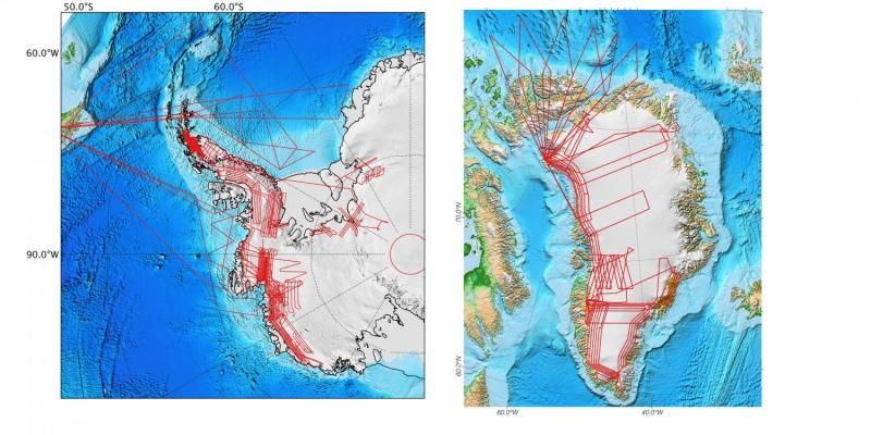
"Jakobshavn's rate of thinning is not uniform during
the year, so we are interested in finding out how
much ice this glacier lost during this summer," said
Eric Rignot, IceBridge science team co-lead and
glaciologist at the University of California, Irvine,
and NASA's Jet Propulsion Laboratory in
Pasadena, Calif.
But more importantly, this campaign's
measurements will allow scientists to evaluate
models of ice sheet melt.
"There are few sites in Greenland where we have
measured melt at the surface, and lots of places
where we don't know how well these models are
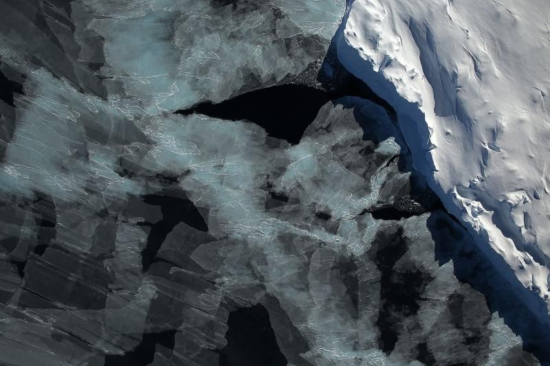
Sea ice in the Bellingshausen Sea seen by the Digital
doing," Rignot said. "So by gathering this altimetry
Mapping System instrument during the 2014 Antarctic
campaign of Operation IceBridge. Credit: NASA / DMS data at the end of the melt season, we'll be able to
Team evaluate how well these models are doing over a
whole range of snow, ice and climate regimes,
which is essential to improve these models for
projecting ice sheet melt with future warming."
The highest priority during this campaign will be
flying the flight paths that the mission successfully Furthermore, the post-melt season campaign will
carried last spring so that researchers can compare help scientists validate the measurements of the
the measurements taken during both campaigns upcoming NASA's Ice, Cloud and Land Elevation
and see how the spring and summer melt season Satellite-2 (ICESat-2) mission, scheduled to launch
has thinned the ice. Some tweaks in the flight paths in 2017.
will also allow IceBridge to fly under some of the
tracks of the European Space Agency's CryoSat-2 "ICESat-2 will observe the ice sheets and the sea
satellite. ice cover year round continuously, not just in the
spring," Rignot said. "The snow and ice properties
Nathan Kurtz, IceBridge's project scientist and a are a bit different at the end of the summer than at
sea ice researcher at NASA's Goddard Space the beginning of the spring, so this campaign will
Flight Center in Greenbelt, Md., said his team give us information on another important part of the
hopes that flying shortly after the melt season has ice's yearly cycle that we didn't get to explore so
ended will allow them to find areas of sea ice not much before."
covered by snow, which will let them take direct
measurements of the freeboard, the fraction of sea Down South
ice that floats above the waterline and makes up
one-eighth of the thickness of the ice floes. At the other end of the planet, IceBridge will use a
Gulfstream G-V aircraft, owned by the National
The second leg of the Arctic campaign will be Science Foundation. The plane will carry the Laser
based in Kangerlussuaq, in western Greenland. Vegetation Imaging Sensor (LVIS), a laser altimeter
IceBridge will fly more than a dozen land ice that can map large areas of sea and land ice from a
missions, again prioritizing flight paths that were high altitude, and another DMS.
flown in the spring campaign. Among other targets
the Falcon will fly over is the Jakobshavn ice The base of operations for the Antarctic campaign
stream, the fastest-melting glacier in the world, will once again be Punta Arenas, Chile. IceBridge
which lost a large area of ice in August. has more than 18 scheduled flights over Antarctica,
which will cover rapidly changing areas, such as
2/3
Smith glacier in the Amundsen Sea and the
                                   southwest corner of the Antarctic Peninsula. The
                                   field campaign will collect measurements of sea ice
                                   in the Bellingshausen and Weddell Seas.

                                   The mission of Operation IceBridge is to collect
                                   data on changing polar land and sea ice and
                                   maintain continuity of measurements between
                                   ICESat missions. The original ICESat mission
                                   ended in 2009, and its successor, ICESat-2, is
                                   scheduled for launch in 2018. Operation IceBridge
                                   is currently funded until 2019. The planned overlap
                                   with ICESat-2 will help scientists validate the
                                   satellite's measurements.

                                   For more about Operation IceBridge and to follow
                                   this year's campaign, visit:
                                   http://www.nasa.gov/icebridge

                                    Provided by NASA's Goddard Space Flight Center
                                   APA citation: NASA to fly parallel science campaigns at both poles (2015, September 24) retrieved 16
                                   November 2020 from https://phys.org/news/2015-09-nasa-parallel-science-campaigns-poles.html

                                   This document is subject to copyright. Apart from any fair dealing for the purpose of private study or research, no
                                   part may be reproduced without the written permission. The content is provided for information purposes only.

                                                                                                                                                3/3

Powered by TCPDF (www.tcpdf.org)
You can also read