77 OUR COUNTRY - INDIA - NCERT
←
→
Page content transcription
If your browser does not render page correctly, please read the page content below
7
                                                   OUR COUNTRY – INDIA

India is a country of vast geographical expanse. In the
north, it is bound by the lofty Himalayas. The Arabian
Sea in the west, the Bay of Bengal in the east and the
Indian Ocean in the south, wash the shores of the           The peninsula is a piece
Indian peninsula.                                           of    land      that    is
   India has an area of about 3.28 million sq. km. The      surrounded by water on
north-south extent from Ladakh to Kanyakumari is            three sides (figure 6.1).
about 3,200 km. And the east-west extent from
Arunachal Pradesh to Kuchchh is about 2,900 km.
The lofty mountains, the Great Indian Desert, the
Northern Plains, the uneven plateau surface and the
coasts and islands present a diversity of landforms.
There is a great variety in the climate, vegetation,
wildlife as well as in the language and culture. In this
diversity, we find unity that is reflected in traditions
that bind us as one nation. India has a population of
more than one hundred twenty crores since the
year 2011. It is the second most populous country of
the world after China.                                                Do you know?
LOCATIONAL SETTING                                                    Large countries
                                                                      which stretch
India is located in the northern hemisphere. The Tropic               extensively from
of Cancer (23°30'N) passes almost halfway through the       east to west do not have
country (Figure 7.2). From south to north, main land        a single Standard Time
of India extends between 8°4'N and 37°6'N latitudes.        for the whole country.
From west to east, India extends between 68°7'E and         The USA and Canada
97°25'E longitudes. If we divide the world into eastern     have seven and six time
and western hemispheres, which hemisphere would             zones respectively. Do you
India belong to? Due to great longitudinal extent of        remember how many
about 29°, there could be a wide differences in local       time zones are there in
                                                            Russia?
time of places located at two extreme points of India. As
such, the difference between these two points would be of

                                        2021–22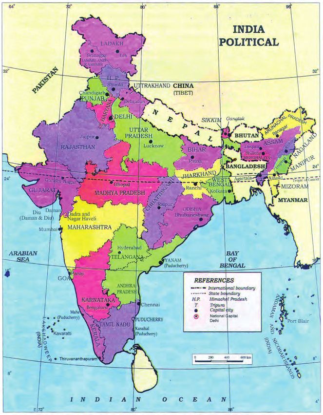
about two hours. As you have learnt earlier, the local time changes by four minutes
for every one degree of longitude. The sun rises about two hours earlier in the east
(Arunachal Pradesh) than in the west (Gujarat). You have already read earlier, why
the local time of longitude of 82°30'E has been taken as the Indian Standard Time.
This meridian or longitude is also termed as the Standard Meridian of India.
INDIA’S NEIGHBOURS
There are seven countries that share land boundaries with India. Find out names

 Figure 7.1 : India and its neighbouring countries

48                                                             THE EARTH : OUR HABITAT

                                                     2021–22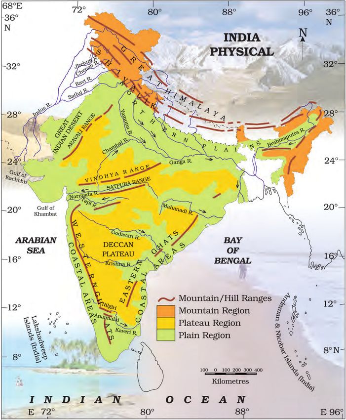
Figure 7.2 : Political map of India

OUR COUNTRY – INDIA                             49

                                      2021–22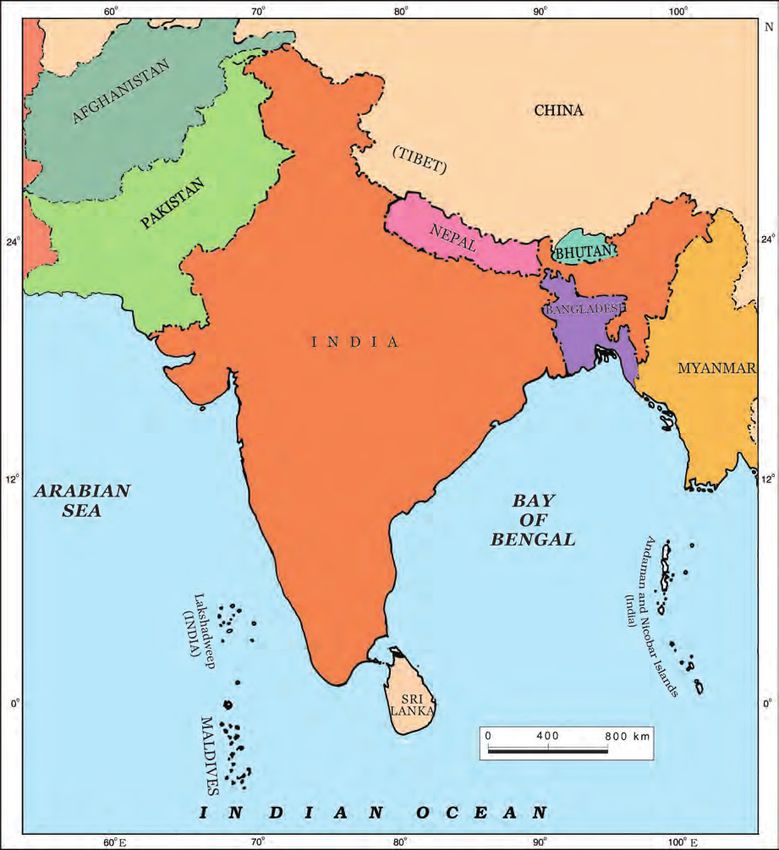
of these countries from the Figure 7.1. How many of these countries do not have
access to any ocean or sea? Across the sea to the south, lie our island neighbours—
Sri Lanka and Maldives. Sri Lanka is separated from India by the Palk Strait.
POLITICAL     AND   ADMINISTRATIVE DIVISIONS
India is a vast country. For administrative purposes, the country is divided into 28

     Figure 7.3 : India : Physical Divisions

50                                                            THE EARTH : OUR HABITAT

                                               2021–22
States and 8 Union Territories (Appendix-I). Delhi is            Alluvial deposits : These
the national capital. The states have been formed                are very fine soils,
mainly on the basis of languages.                                brought by rivers and
PHYSICAL DIVISIONS                                               deposited in the river
                                                                 basins.
India is marked by a diversity of physical features
such as mountains, plateaus, plains, coasts and                  T r i b u t a r y : A river or
islands. Standing as sentinels in the north are the              stream which contributes
lofty snow-capped Himalayas. Him+alaya mean ‘the                 its water to a main river
                                                                 by discharging it into
abode of snow’. The Himalayan mountains are
                                                                 main river from either
divided into three main parallel ranges. The                     side (Figure 6.1).
northernmost is the Great Himalaya or Himadri.
The world’s highest peaks are located in this range.
Middle Himalaya or Himachal lies to the south of
Himadri.                                               Many
                                                                             Do you know?
popular hill stations are situated here. Find out the
names of five hill stations. The Shiwalik is the                            The Ganga and
southernmost range.                                                         the Brahma-
                                                                            putra form the
    The Northern Indian plains lie to the south of the
                                                                 world’s largest delta, the
Himalayas. They are generally level and flat. These are          Sundarbans delta. The
formed by the alluvial deposits laid down by the rivers–         delta is triangular in
the Indus, the Ganga, the Brahmaputra and their                  shape. It is an area of
tributaries. These river plains provide fertile land for         land formed at the mouth
cultivation. That is the reason for high concentration of        of the river (Where rivers
population in these plains.                                      enter the sea, that point
    In the western part of India lies the Great Indian           is called the mouth of the
desert. It is a dry, hot and sandy stretch of land. It has       river, Figure 6.1).
very little vegetation.
    To the south of northern plains lies the Peninsular
plateau. It is triangular in shape. The relief is highly
                                                                              Let’s Do
uneven. This is a region with numerous hill ranges and
valleys. Aravali hills, one of the oldest ranges of the world,              Many girls
border it on the north-west side. The Vindhyas and the                      are named
                                                                            after rivers
Satpuras are the important ranges. The rivers Narmada
                                                                 eg. Yamuna, Mandakini,
and Tapi flow through these ranges. These are west-              and Kaveri. Do you know
flowing rivers that drain into the Arabian Sea. The Western      anyone in your locality
Ghats or Sahyadris border the plateau in the west and            who is named after a
the Eastern Ghats provide the eastern boundary. While            river? Ask your parents
the Western Ghats are almost continuous, the Eastern             and others and make a
Ghats are broken and uneven (Figure 7.3). The plateau is         list of such names.
rich in minerals like coal and iron-ore.                         Could you also find
    To the West of the Western Ghats and the East of             other names related to
Eastern Ghats lie the Coastal plains. The western                water e.g. Shabnam?

OUR COUNTRY – INDIA                                                                          51

                                           2021–22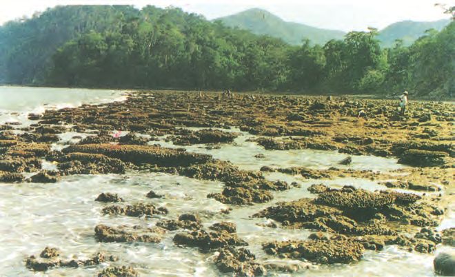
Do you know?
                                                                     Corals       are
                                                                     skeletons     of
                                                                     tiny    marine
                                                           animals called Polyps.
                                                           When the living polyps
                                                           die, their skeletons are
                                                           left. Other poplyps grow
                                                           on top of the hard
                                                           skeleton which grows
                                                           higher and higher, thus
                                                           forming the coral islands.
                                                           Figure 7.4 shows Coral
                                                           islands.
Figure 7.4 : Coral Islands
coastal plains are very narrow. The eastern Coastal plains are much broader. There
are a number of east flowing rivers. The rivers Mahanadi, Godavari, Krishna and
Kaveri drain into the Bay of Bengal. These rivers have formed fertile deltas at their
mouth. The Sunderban delta is formed where the Ganga and Brahmaputra flow
into the Bay of Bengal.

          Danger Waters

52                                                             THE EARTH : OUR HABITAT

                                       2021–22
OUR COUNTRY – INDIA             53

                      2021–22
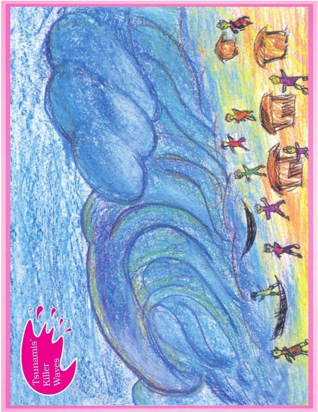
Two groups of islands also form part of India.
                               Lakshadweep Islands are located in the Arabian Sea.
                               These are coral islands located off the coast of Kerala.
                               The Andaman and the Nicobar Islands lie to the
                               southeast of the Indian mainland in the Bay of Bengal.
                               Do you know which group of islands were affected by
                               the Tsunami in 2004? Find out through newspaper
                               reports and by speaking to people how in different
                               ways people faced this challenge when Tsunami struck
                               the Indian coast. Tsunami is a huge sea wave generated
                               due to an earthquake on the sea floor.

     1. Answer the following questions briefly.
        (a)   Name the major physical divisions of India.
        (b)   India shares its land boundaries with seven countries. Name them.
        (c)   Which two major rivers fall into the Arabian Sea?
        (d)   Name the delta formed by the Ganga and the Brahmaputra.
        (e)   How many States and Union Territories are there in India? Which states
              have a common capital?
        (f)   Why do a large number of people live in the Northern plains?
        (g)   Why is Lakshadweep known as a coral island?

     2. Tick the correct answers.
        (a)   The southernmost Himalayas are known as
              (i) Shiwaliks              (ii) Himadri             (iii) Himachal
        (b)   Sahyadris is also known as
              (i) Aravali                (ii) Western Ghats       (iii) Himadri
        (c)   The Palk Strait lies between the countries
               (i) Sri Lanka and Maldives
              (ii) India and Sri Lanka
              (iii) India and Maldives
        (d)   The Indian islands in the Arabian Sea are known as
               (i) Andaman and Nicobar Islands
              (ii) Lakshadweep Islands
              (iii) Maldives

54                                                                      THE EARTH : OUR HABITAT

                                             2021–22
(e) The oldest mountain range in India is the
(i) Aravali hills (ii) Western ghats (iii) Himalayas
3. Fill in the blanks.
(a) India has an area of about ________________.
(b) The Greater Himalayas are also known as_________________.
(c) The largest state in India in terms of area is__________________.
(d) The river Narmada falls into the __________________ sea.
(e) The latitude that runs almost halfway through India is ___________.
Map skills
1. On an outline map of India, mark the following.
(a) Tropic of Cancer
(b) Standard Meridian of India
(c) State in which you live
(d) Andaman Islands and Lakshadweep Islands
(e) Western Ghats and Eastern Ghats
OUR COUNTRY – INDIA 55
2021–22You can also read