National Policy Statement for Freshwater Management Implementation Review Southland - Murihiku
←
→
Page content transcription
If your browser does not render page correctly, please read the page content below
National Policy Statement for Freshwater
Management Implementation Review

Southland – Murihiku
Published in August 2017 by the
Ministry for the Environment
Manatū Mō Te Taiao

© Crown copyright New Zealand 2017

This document is available on the Ministry for the Environment website: www.mfe.govt.nz.
Contents
Regional overview                                                    4

Review methodology                                                   8

Regional context for freshwater management                           9
      Existing plans                                                 9
      Non-regulatory initiatives                                     9
      Iwi and rūnanga                                                9

Approach to implementing the NPS-FM                                 11
     Progressive implementation programme                           11
      Priorities                                                    11
      Stakeholder views                                             12
      NPS-FM progress in major catchments                           12

Achieving the objectives of the NPS-FM                              13
      Limit setting and allocation                                  13
      Integrated management                                         13
      Stakeholder views                                             13

Community engagement                                                14
    Engagement strategy                                             14
      Stakeholder views                                             14

Engaging with iwi                                                   15

Engaging with territorial authorities                               16

Capacity and capability                                             17
      Council capacity and capability                               17
      Community capacity and capability                             17
      Iwi and hapū capacity and capability                          17

Information                                                         18
      Science and economics programme                               18
      Monitoring                                                    18
      Accounting                                                    18
      Stakeholder views                                             19

Plan implementation                                                 20
      Stakeholder views                                             20

Conclusion and recommendations                                      21

                                             Southland – Murihiku    3
Regional overview
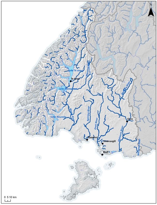
Southland covers an area of 34,000 square kilometres of the lower South Island, Stewart
Island/Rakiura and a large number of smaller islands in Fiordland and Foveaux Strait. It extends
north to Awarua Point in the west and to Waiparau Head in Progress Valley in the east. The
western portion is largely indigenous forest and the east is alpine areas and rolling farmland.
More than half of the region is protected land, including Fiordland National Park and part of
the Catlins. Most lowland areas, however, have been extensively modified. About 98,000
people live in Southland,1 under the jurisdiction of three territorial authorities: Invercargill City
Council, Southland District Council and Gore District Council.2
The western mountains are among one of the wettest places in the world, averaging more
than 8000 millimetres of rainfall per year in some parts.3 In parts of the eastern plains and hills,
however, rainfall averages as little as 800 millimetres because of the rain-shadow effect.
The four major river catchments in the region are the Waiau, Mataura, Ōreti and Aparima
(figure 1). Together, these cover over half of the total land area in Southland. Most of these
rivers drain into estuaries, coastal lakes and lagoons, including the Waituna Lagoon and the
internationally recognised Awarua Wetlands. There are also around 200 lakes in the region,
including six large lakes: Te Anau, Manapōuri, Hauroko, Pōteriteri, Monowai and McKerrow.
These western glacial lakes are central to regional tourism.
Although 90 per cent of Southland wetlands have been drained, groundwater remains
generally close to the surface in unconfined aquifers.4 Water and contaminants pass quickly
and easily between these aquifers and surface water bodies, meaning that water quality or
quantity pressures in one will have an effect on the other. Springs provide half of the flow in
Southland rivers, particularly in the lowland areas.
Primary production has long been a major contributor to the region’s economy, and pasture
accounts for 85 per cent of the non-conservation land. Sheep and beef farming remain the
dominant form of farming, but the introduction of irrigation and high milk prices have allowed
dairying to expand into areas where it was not previously viable. As a result, the estimated
number of dairy cows in the region increased 190 per cent over the past decade, from 376,000
1
Statistics New Zealand. No date. Subnational population estimates. Retrieved from
http://nzdotstat.stats.govt.nz/wbos/Index.aspx?DataSetCode=TABLECODE7501 (13 July 2017).
2
Environment Southland. 2015. Land Use Change – Agriculture. Retrieved from
www.es.govt.nz/Document%20Library/Factsheets/Science%20summaries/land_use_change_-
_agriculture.pdf (13 July 2017).
3
National Institute of Water and Atmospheric Research. 2013. The climate and weather of Southland
(2nd edn). NIWA SCIENCE AND TECHNOLOGY SERIES No 63. Wellington: National Institute of Water
and Atmospheric Research. Retrieved from www.niwa.co.nz/static/Southland%20ClimateWEB.pdf
(13 July 2017).
4
Moran E, Pearson L, Couldrey M, Eyre K. 2017. The Southland Economic Project: Agriculture and Forestry.
Technical Report. Publication no. 2017-02. Invercargill: Environment Southland. Retrieved from
http://waterandland.es.govt.nz/repository/libraries/id:1tkqd22dp17q9stkk8gh/hierarchy/Scientific%20re
ports/Agriculture%20and%20Forestry%20Report.pdf (13 July 2017).
4 National Policy Statement for Freshwater Management Implementation Reviewin 2006 to 709,000 in 2016.5 This has raised demand for irrigation and placed increased
pressure on water quality.
Hydro-electric power generation at three stations makes up 99.3 per cent (34.1 billion cubic
metres per year) of the total consented volume of water in Southland. Unlike most other
hydro-electricity generation schemes, the Manapōuri scheme discharges water from Lake
Manapōuri directly to the ocean, rather than returning it to the natural catchment. This makes
it a consumptive user of fresh water. The remaining 250 million cubic metres per year are
divided among irrigation, stock water, industrial use, town supply and other uses (figure 2).
Water quality and ecosystem health in most of Fiordland and Stewart Island/Rakiura are
exceptionally high.6 Although there is localised pressure from tourism, the high volume of
water flowing through the system and minimal human development minimises the overall
impact. Water quality is also generally high in the upper reaches of catchments across the
region. Overall, most monitored sites are within the A band for most attributes listed in
appendix 2 of the National Policy Statement for Freshwater Management (NPS-FM).7 All
monitored lakes and 80 per cent of monitored rivers are in the A or B bands for E. coli and
considered generally safe for swimming or other primary contact recreation.
In some parts of the region, however, water quality and ecosystem health are under pressure,
primarily due to diffuse discharges from intensive agricultural run-off and urban stormwater.
As a result, water quality and ecosystem health generally degrade as water flows from the
northern and western hills to the eastern and southern lowlands, particularly in the lower
Ōreti and Mataura rivers. Since 2000, more than half of monitored surface water and two-
thirds of groundwater sites have shown increasing levels of nitrate.8 Macroinvertebrate
communities are declining in a third of monitored sites.9 E. coli levels measured at 10 river
sites do not meet the minimum acceptable state for primary contact recreation, and six of
these are below the national bottom line set in appendix 2 of the NPS-FM and do not meet the
minimum acceptable state for secondary contact recreation.10
5
Statistics New Zealand. 2017. Agricultural Production Statistics: June 2016. Retrieved from
www.stats.govt.nz/browse_for_stats/industry_sectors/agriculture-horticulture-
forestry/AgriculturalProduction_final_HOTPJun16final.aspx (14 June 2017).
6
Environment Southland. 2015. Water and Land 2020 and Beyond: Water Quality in Southland 2014.
Retrieved from www.es.govt.nz/Document Library/Factsheets/Other factsheets/Water Quality in
Southland web.pdf (14 June 2017).
7
Environment Southland. 2017. Water Quality in Southland: Current State and Trends – Technical Report.
Publication No 2017-04. Dunedin: Environment Southland. Retrieved from www.es.govt.nz/Document
Library/Consultations/2016/Proposed Southland Water and Land Plan/Supporting Documents/7 - Water
Quality in Southland - Current State and Trends - April 2017.pdf (14 June 2017).
8
Environment Southland. 2017. Water Quality in Southland: Current State and Trends – Technical Report.
Publication No 2017-04. Dunedin: Environment Southland. Retrieved from www.es.govt.nz/Document
Library/Consultations/2016/Proposed Southland Water and Land Plan/Supporting Documents/7 - Water
Quality in Southland - Current State and Trends - April 2017.pdf (14 June 2017).
9
Environment Southland. 2016. State and Trends in Freshwater Macroinvertebrate Community Health in
Southland. Retrieved from www.es.govt.nz/Document Library/Presentations/Science Conference
Posters 2016/State and Trends in Freshwater Macroinvertebrate Community Health in Southland.pdf
(14 June 2017).
10
Environment Southland. 2017. Water Quality in Southland: Current State and Trends – Technical Report.
Publication No 2017-04. Dunedin: Environment Southland. Retrieved from www.es.govt.nz/Document
Library/Consultations/2016/Proposed Southland Water and Land Plan/Supporting Documents/7 - Water
Quality in Southland - Current State and Trends - April 2017.pdf (14 June 2017).
Southland – Murihiku 5Figure 1: Major water bodies in the Southland region Source: Ministry for the Environment 6 National Policy Statement for Freshwater Management Implementation Review
Figure 2:     Water take consents by primary use in the Southland region
              (excluding hydro-electric power generation)

 100%

   75%

   50%

   25%

    0%
              Irrigation:       Industrial: 83      Stock:       Town Supply:         Other:
            104 consents,         consents,      848 consents    49 consents,      22 consents,
            50 million m³       55 million m³    30 million m³   33 million m³     73 million m³
               per year            per year        per year        per year          per year

Source: Land, Air, Water Aotearoa

                                                                             Southland – Murihiku   7
Review methodology The information and analysis contained in this report are based on evidence collected from a questionnaire completed by Environment Southland (the Council), a series of interviews and panel discussions with relevant parties, planning documents and associated reports, and the Ministry’s ongoing relationships and projects across the region. The overall review team consisted of officials from the joint Ministry for the Environment and Ministry for Primary Industries Water Directorate with the assistance of two independent consultants who are both certified hearings commissioners with more than 30 years of experience in freshwater management. The review team conducted a series of panel discussions with Council executives and elected councillors, senior Council staff and stakeholder representatives. Additional interviews and panel discussions were held with representatives from national sector organisations. Following each meeting, attendees were given the opportunity to revise or supplement the meeting notes to ensure their views were recorded accurately. While the review team has made efforts to confirm information where possible, much of the information included in the review is based on the accounts and perspectives of those involved and often cannot be verified independently. It is important to note that none of the rūnanga representatives invited to our review hui attended. We recognise this as a significant limitation of our review, particularly given the complexity of iwi and hapū relationships and the influence of Treaty of Waitangi settlement arrangements on freshwater management. The following comments are based, therefore, on evidence gathered through the Ministry’s ongoing conversations and relationships with representatives in the area rather than a systematic evidence-gathering process and should be read with that caveat in mind. Stakeholder and tāngata whenua representatives did not necessarily speak with mandate as official representatives of their iwi, rūnanga or organisation nor are they presumed to represent all in their wider communities. They were, however, primary sources with direct experience of the Council’s work. Because of varying regional contexts, some issues are considered more or less relevant in different regions. Therefore, some topics that appear in other regional chapters but that were not raised by the Council, iwi and hapū or stakeholders in this region have been omitted from this chapter. 8 National Policy Statement for Freshwater Management Implementation Review
Regional context for
freshwater management
Environment Southland says that it sees freshwater management as its top priority, and that
there is agreement within the Council that something must be done about improving water
quality. The region has experienced 30 years of rapid land use change. Drivers of declining
water quality include intensification and winter grazing, together with ageing stormwater and
sewage systems in urban centres.

Existing plans
Fresh water was previously managed under the Regional Water Plan for Southland, which
became fully operative in 2010.

Before the 2011 NPS-FM took effect, Environment Southland had already started its Water and
Land 2020 and Beyond programme to develop a new regional plan. It was in response to water
quality deterioration primarily from dairy expansion in the past two decades. This programme
is in partnership with Ngāi Tahu ki Murihiku, and its objective is to maintain and improve
Southland’s water quality.

Environment Southland has developed physiographic zones that will underpin its scientific
research and management options. The physiographic zones were defined based on similar
landform types, hydrology and other characteristics that affect water quality. Contaminants
move through the soil and groundwater and into rivers and streams differently in the different
zones. The physiographic zones are a way of grouping areas of Southland that have similar
water. The approach aims to improve understanding of the relationships between Southland’s
water origin, soils, geology and water quality.

Non-regulatory initiatives
The Council reports that a collaborative rural extension programme has been developed to
improve the collective (Council and sector groups) effectiveness to deliver ‘good management
practice’ including farm environment plans within Southland.

An urban ‘Three Waters’ work programme has started with the district and city councils of
Southland to coordinate, programme and improve the maintenance and upgrading of all
wastewater, storm water and potable water supplies. The Council reports that this work
programme seeks to improve consent compliance, streamline the re-consenting process and
create a forum to explore how the urban environment can comply with its NPS-FM obligations.

Iwi and rūnanga
Ngāi Tahu are mana whenua in Southland and are represented by the iwi governance group
Te Rūnanga o Ngāi Tahu (TRONT). The four Ngāi Tahu rūnanga in the region are Te Rūnanga
o Awarua, Te Rūnanga o Ōraka Aparima, Te Rūnanga o Hokonui and Te Rūnaka o Waihōpai.
These are referred to collectively as Ngāi Tahu ki Murihiku and are represented in resource
management issues by Te Ao Mārama Inc.

                                                                        Southland – Murihiku    9
The four Ngāi Tahu ki Murihiku rūnanga, Environment Southland, Otago Regional Council and the territorial authorities in the two regions participate in a joint management committee called Te Rōpū Taiao. This has been in place since the 1990s to discuss resource management and local government issues at a high level. Ngāi Tahu ki Murihiku lodged an Iwi Management Plan with Environment Southland in 1997 and a revised plan in 2008. 10 National Policy Statement for Freshwater Management Implementation Review
Approach to implementing the NPS-FM

Progressive implementation programme
Environment Southland notified the Proposed Water and Land Plan (the Proposed Plan) in
June 2016. The Proposed Plan included provisions for water quantity and quality at the
regional scale.

Under the Proposed Plan, all farmers will need to complete a farm environment plan and
implement good management practices. Once these are complete, however, most would not
need a resource consent to farm. Further dairy conversion and intensification is strongly
discouraged and is a non-complying activity in some physiographic zones.

As the programme proceeds, region-wide provisions (objectives, policies and rules) in the
Proposed Plan may be replaced by provisions specific to freshwater management units
(FMUs). These will be tailored to respond to the pressures faced within each particular
catchment. The Council says that its FMU process is a mountains to the sea approach,
which includes estuaries.

In addition to this new plan, the Regional Policy Statement has been refreshed and will soon
become operative. The Council says that the Regional Policy Statement reflects the NPS-FM
2014. The Council intends for all relevant plan changes to be notified by 2023 so as to
complete the programme by December 2025.

Priorities
The Council has established five FMUs in the region: Fiordland and the Islands (including
Stewart Island/Rakiura), Aparima, Ōreti, Mataura and Waiau.

At the time of the review meetings, the Council reported it would begin with the Fiordland and
Islands FMU to test the rules and limit-setting process before rolling it out across other FMUs.
There was a deliberate decision to progress this FMU first because less scientific and economic
research will be required to understand the pressures in the area. The Council said it hoped to
use Fiordland and the Islands as a pilot to test its community engagement model and overall
planning approach. At the same time, the Council would prepare background scientific and
economic work to address the remaining FMUs in late 2017 and 2018.

The Council notes that, while Fiordland and Islands are less complex in terms of scientific and
economic analysis, community engagement will be a challenge because of the national
significance of the area. It will be difficult to balance the protection of natural heritage with
local ambitions for development and growth.

Council staff say the Ōreti FMU will likely be the most challenging because of the mix of rural
and urban environments (including Invercargill) and the highly modified New River Estuary at
the bottom of the catchment.

Following feedback from the public and stakeholders, the Council decided there was a need for
both a much better understanding of the science to inform the limit-setting process and an
understanding of the economic impact on businesses and communities before initiating the
limit-setting process. It also decided that there was a need for a statutory water and land plan

                                                                            Southland – Murihiku    11
to ‘hold the line’ on water quality in the meantime and to provide a regulatory foundation for
the future limit-setting process.
Stakeholder views
Stakeholders we spoke to said that they support the Council’s decision to do the Fiordland and
Islands FMU first, and allow time to do the science work in the other areas and work out the
process. They are confident the Council has put enough resources into this (at least the science
side, maybe less so the community engagement side). They recognised the Council had a focus
on improving freshwater management before the NPS-FM.
Stakeholders raised some concerns about having to work on the Proposed Plan and FMU
processes at the same time. They would prefer the Council to wait for the economics work to
be finished before finalising the Proposed Plan.
NPS-FM progress in major catchments
FIORDLAND AND THE ISLANDS FMU
This FMU process is under way. Te Ao Mārama and the Council are doing scene-setting reports
for the FMU, for example, identifying existing community groups, existing resource consents
and how iwi and hapū use areas.
MATAURA FMU
Scheduled to start 2017.
APARIMA FMU
Scheduled to start 2017.
WAIAU FMU
Scheduled to start 2018.
ŌRETI FMU
Scheduled to start 2018.
12 National Policy Statement for Freshwater Management Implementation ReviewAchieving the objectives of the NPS-FM
Limit setting and allocation
The Council says that it made a conscious decision to better understand how systems work
before getting into limit setting. It understands that it has water quality challenges but does
not yet fully understand the drivers and interactions. It has learnt, from watching other
regions, that having more information ready at the start helps the limit-setting process. This is
why it has put a science programme in place to get more information on surface water and
groundwater within the region, and an economics programme to understand the costs of
implementing the NPS-FM.
The Proposed Plan provides direction for allocation of surface water and groundwater.
However, the Council says that the appropriateness of this regional approach will be tested
by the community during FMU processes, and more catchment-specific flows and levels may
be established.
As far as the Council understands, over allocation of surface water or groundwater is not really
an issue, except in the Manapōuri catchment, which is likely to be fully or over allocated. The
Council has a research work stream that it says will provide information to better assess
allocation issues.
Integrated management
Many of the region’s catchments end with an estuary, so the Council places importance on the
concept of ki uta ki tai/mountains to the sea in freshwater management. It says that this is
supported by its partner Te Ao Mārama.
Stakeholder views
Stakeholders report that there still seems to be some confusion around relationships between
objectives and policies in the Proposed Plan and the limit-setting process at an FMU level. They
expressed concern that the FMU limit-setting process may affect land values if rules are more
strict in some areas than others.
Stakeholders we spoke to from the agricultural sector expressed concerns about the lack of
enabling provisions for farming in the Proposed Plan. They also said that farmers have been
doing good work by implementing good management practices and this is not being
adequately recognised.
Southland – Murihiku 13Community engagement
Engagement strategy
The Council says that it has engaged extensively with the community on the Proposed Plan.
Part of the early engagement was the establishment of a Water and Land 2020 and Beyond
steering group in late 2011. The group includes representatives from agricultural industry
groups, the farming community, conservation groups, territorial authorities and iwi.
The Council reports that the limit-setting process is scheduled to start this year and will use the
collaborative science and economic work. The Council has also confirmed that this process will
occur in a collaborative manner.
The Council intends to have a generic process in place and key outcomes that will be the
basis of FMU discussions, but it expects that each community will take its own unique path.
Engagement to date has primarily consisted of raising community awareness of the NPS-FM.
All the front-loading with the community does mean the community is better informed.
Stakeholder views
Overall, stakeholders we spoke to said that Council engagement with the community has
improved but there is still work to be done. Some expressed disappointment at what they
consider was a lack of engagement on the Proposed Plan. Stakeholders say that the process
could have been better if they had been involved earlier, and there could have been better
discussion with stakeholders between consultation on the draft plan and final Proposed Plan.
They said this is why there were negative reactions to the Proposed Plan, and that this seemed
to come as a surprise to the Council.
Stakeholders we spoke to said that there has not been much engagement about what the FMU
engagement process might look like. They said that the Canterbury model has a lot of good
points to learn from but is very expensive. Southland could perhaps adapt a ‘scaled-down
version’. They would like a process that:
has involvement and engagement with all stakeholders at a local level, and involves
people the full length of the catchment
is led by locals (not councillors)
has scientists talking about the facts to ‘take the emotion out of it’
allows more ability to make compromises and tweaks
takes the community on a journey to work out how to meet outcomes without harming
the local economy
has higher levels of buy-in than a traditional process.
14 National Policy Statement for Freshwater Management Implementation ReviewEngaging with iwi
The Water and Land 2020 and Beyond programme is a partnership project between the
Council and Ngāi Tahu ki Murihiku. In addition, a Charter of Understanding was signed in early
2016 between the four Papatipu Rūnanga, Environment Southland, Otago Regional Council
and the five relevant territorial authorities.
The Council says that Te Ao Mārama has been a partner in shaping the Proposed Plan. It also
has a representative on the Hearing Committee for the Proposed Plan. TRONT has also been
engaged in the Proposed Plan development.
Ngāi Tahu ki Murihiku does not have a decision-making role within the Council itself. The
Council says there is uncertainty about the future of Māori involvement in decision-making,
with central government making statements about having iwi ‘around the table’ but not
finalising what that should look like yet. The Council feels it is involving rūnanga in decision-
making, and that any formal requirements will not be particularly onerous.
Southland – Murihiku 15Engaging with territorial authorities The Council says that the three territorial authorities in the region are already involved in the economics and science programme to support NPS-FM implementation. Invercargill provides challenges because it has a static population as well as ageing urban water infrastructure. Similar issues exist in other larger communities, such as Gore. 16 National Policy Statement for Freshwater Management Implementation Review
Capacity and capability

Council capacity and capability
The Council says that it will need other skill sets to undertake more collaborative engagement.
These include social science and community facilitation skills. There are also challenges in
communicating scientific and economic information to communities.

Building capacity may involve redeploying existing staff and hiring new people. Council staff
say that they need to get greater certainty from councillors about the process before they can
act on vacancies and filling them with the skills they need.

Community capacity and capability
The Council wants stakeholders to be involved in the process as much as they can (some
stakeholders are already involved in the science and economics programmes). They say
that there is a risk that the community may suffer engagement fatigue or ‘burn out’. To
address this, the Council is trying to do as much work as possible up front to ensure short
and fruitful conversations.

Iwi and hapū capacity and capability
The Council says that there are capacity issues at Te Ao Mārama (the environmental arm of
the collective Southland Ngāi Tahu Rūnanga), due to its large workload. It notes that Te Ao
Mārama is actively supported by TRONT staff based in Christchurch.

                                                                          Southland – Murihiku   17
Information
Science and economics programme
In mid-2014, the Council established the Southland Science Programme to inform FMU
processes under the NPS-FM. The three-year work programme has four work streams:
1. land use inputs – better understanding the effects of land use on water
2. physiographics of Southland – identifying areas with similar characteristics that affect
water quality
3. fluxes and flows – interaction between groundwater and surface water
4. ecosystem response.
The Council has also established the Southland Economics Project, which is developing tools to
understand the socio-economic impacts of implementing the NPS-FM in Southland. It is built
on the same data as the science programme. This project includes developing community
profiles for towns across Southland.
Both the science and economics programmes will provide information to use in conversations
with communities around FMUs, to enable more engaging and informed conversations. The
Council says that the assumptions built into ‘off-the-shelf’ models often do not reflect the
complexity of the region.
Monitoring
The Council says that, for the time being, it will maintain regional State of the Environment
sites, although it says there will be ongoing changes to their parameters. There may be
additional requirements for whatever monitoring is required for objectives set through the
FMU process, this could involve additional monitoring sites or dropping off of existing sites.
Work is currently being done with Te Ao Mārama about cultural indicators and partnered
monitoring programmes, as well as with the Department of Conservation to align monitoring.
The Council is also interested in looking at the potential role of citizen science in monitoring.
This is partly as a data-gap filler and partly to get greater buy-in from community members and
behaviour change.
Accounting
The Council has an internal team that is looking at existing sites and other measures that might
be needed to create an accounting system. It notes water quality accounting is more difficult
than quantity. This is likely to be a combination of field measurements and a paper exercise
(for Fiordland and Islands, the emphasis is likely to be on a paper exercise). It is also working
on increasing the amount of public reporting of water quantity and quality information.
18 National Policy Statement for Freshwater Management Implementation ReviewStakeholder views
Stakeholders had varied responses on information to support NPS-FM implementation. They
are pleased the Council has focused on doing the science first, they consider this to be a
reasonably unique approach for a council.
In regard to the Proposed Plan, they said they have not seen a lot of economic analysis, even in
the Section 32 Report.
Southland – Murihiku 19Plan implementation The Council says a variety of programmes are being, or will be, used to implement the NPS-FM on the ground in Southland. These include management tools such as: good and best management practices, farm plans and industry audited self-management (although the latter is in the early stages). These are administered by pre-existing extension and advice services and consenting. The Council says that the approach taken is evolving. Farm plans are being used as a tool to drive good management practices in advance of the FMU limit-setting process (through the Proposed Plan). For example, it is now a requirement that a farm business be able to provide the Council with a copy of a farm plan that demonstrates its operations are at a standard equating to good management practice on demand. To implement this approach, the Council is investing in its extension services to ensure compatibility with the regulatory framework, although a lot of the responsibility for delivery rests with individuals and industry. Early discussions are being held with industry and consultants to examine opportunities to leverage industry capacity to meet the timeframes established in the regulation. The Council says that this is about getting people investing their money in doing the right and most effective things for their land type. Stakeholder views Stakeholders expressed concern that the Proposed Plan does not give land owners enough time to change. They do not necessarily agree that declining consent applications for dairy conversions is the best option. 20 National Policy Statement for Freshwater Management Implementation Review
Conclusion and recommendations
The following are the views of government officials about the approach to NPS-FM
implementation in the region.
Environment Southland has invested in collecting high quality scientific and economic
information to inform the limit-setting process. This should help ensure that its FMU
processes are well informed. However, the Council needs to ensure it has clear criteria for
assessing when it has sufficient evidence to start setting limits and mitigating the effects
of land use.
The Council also needs to have appropriate mitigation strategies in place to allow the
limit-setting process to continue in an efficient manner if the collection and analysis of
science and economic information takes longer than expected (eg, base conclusions on
information already collected and expert opinion).
It is important that the Council prioritise its efforts on addressing areas where water
quality is degrading. The Council must act quickly to stop further degradation in areas
under pressure.
It is good to hear that the Council is investigating which engagement processes have
worked for other councils, but the Council needs to make a decision on its approach so
that the community can begin to have a discussion about how fresh water will be
managed in its FMUs. Stakeholders we spoke to said they would appreciate early
engagement with the Council.
Southland – Murihiku 21You can also read