NORTH BEACH/SEAGATE AND OCEAN OVERLAY DISTRICT DEVELOPMENT REVIEW APPLICATION
←
→
Page content transcription
If your browser does not render page correctly, please read the page content below
NORTH BEACH/SEAGATE AND
OCEAN OVERLAY DISTRICT
DEVELOPMENT REVIEW
APPLICATION
Address of Property: ________________________________________________
Petition No. ____________________________
Date Received: _____________________________
Applications for the Beach Overlay District Area may be submitted to the Planning and Zoning
Department between the hours of 8:00 a.m. and 5:00 p.m., Monday thru Friday. Please print or
type all of the required information, and ensure that the application is complete and accurate.
In order to be accepted for processing, the submission must include:
1. A completed application;
2. Standard application items pursuant to Sections 2.4.3 (A), (B), (C), (D) and (G) of the Land
Development Regulations.
3. Beach Property Owners Application Checklist
4. Four (4) complete sets of plans, together with one (1) 11” x 17” reduced copy, in collated,
stapled and folded sets:
5. Processing fee of $1,610.00 (make checks payable to the City of Delray Beach).
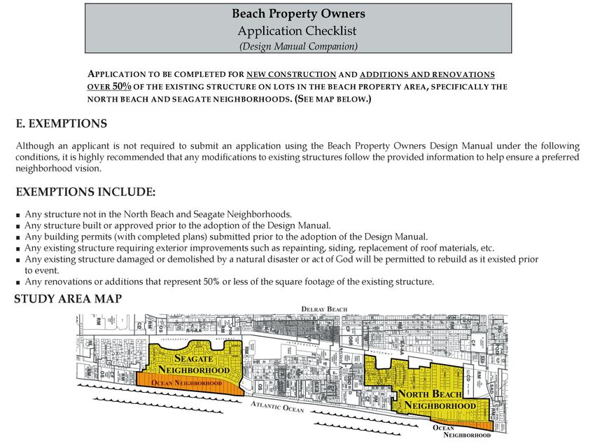
The Beach Review Application is to be completed for new construction, and additions and renovations that
measure over 50% of the existing structure square footage on lots in the Beach Overlay District Area,
specifically, the Ocean, North Beach and Seagate Neighborhoods. The complete, initial evaluation of the
petition by both the City staff and an independent design review consultant retained by the City of Delray
Beach, takes approximately 30 days from the date of receipt.
Completed applications that Meet all the regulations, design guidelines thresholds and overall design
intent for buildings, landscaping and site plan issues will receive a “Letter of Compliance” allowing the
applicant to apply for building permits.
Completed applications that Do Not Meet all or part of the regulations, design guidelines thresholds, and
overall design intent can revise the non-conforming element(s)to meet the requirements and re-submit
one time within thirty (30) days of receipt of initial comments without an additional review fee. An
additional review fee of $1,610.00 is required for plans submitted after 30 days of the receipt of
initial comments.
If the applicant decides to appeal any “design guidelines” that exceed the threshold set forth in Section II
of the Design Manual, the application and recommendations will be forwarded to the Site Plan Review and
Appearance Board (SPRAB) or Historic Preservation Board (HPB) for review and determination of
compliance and/or waivers. The associated waiver request must be submitted pursuant to LDR Section
2.4.7(B).
Note: Citizens that request to do a presentation that is on a portable flash drive device or CD/DVD, must
provide their media to the Planning and Zoning Department, no later than 12:00 pm one day prior to the
meeting where they wish to present. Board-mounted displays may not be used as a part of a presentation.
06/15
CITY OF DELRAY BEACH PLANNING AND ZONING DEPARTMENT

Project Name: ______________________________________________________________

Address or General Location: __________________________________________________

__________________________________________________________________________

__________________________________________________________________________

PART ONE - APPLICANT INFORMATION:

APPLICANT

Name: ____________________________________________________________________

Address: ___________________________________________________________________

__________________________________________________________________________

__________________________________________________________________________

Telephone Number:_________________ E-Mail/Fax: _________________________

AGENT

Name: ____________________________________________________________________

Address: ___________________________________________________________________

__________________________________________________________________________

__________________________________________________________________________

Telephone Number:_________________ E-Mail/Fax: ________________________

OWNER (if other than applicant)

Name: ____________________________________________________________________

Address: ___________________________________________________________________

__________________________________________________________________________

__________________________________________________________________________

Telephone Number:_________________ E-Mail/Fax: ________________________

                                                                                  2
PART TWO – PROPERTY INFORMATION:
Property Control Number: _____________________________________________________
Legal Description (attach separate sheet if necessary): ______________________________
__________________________________________________________________________
__________________________________________________________________________
__________________________________________________________________________
Overlay District:_____________________________________________________________
Zoning Designation: __________________________________________________________
Existing Use of Property: ______________________________________________________
__________________________________________________________________________
__________________________________________________________________________
__________________________________________________________________________
__________________________________________________________________________
__________________________________________________________________________
Description of Work (attach separate sheet if necessary): ____________________________
__________________________________________________________________________
__________________________________________________________________________
__________________________________________________________________________
__________________________________________________________________________
__________________________________________________________________________
Attach pictures to show work areas. Label each picture to describe what is to be done in each
area.
In addition to the Standard application items in Section 2.4.3, the application must include the
following:
Color Samples
Samples of Building Materials (Exhibits to be no greater than 8.5” x 11”)
Photographs of the adjacent residences.
Photographs of the streetscape if there is an existing median.
3PROJECT RELIEF
Does any component of the project require relief from any of the applicable requirements
noted in the Land Development Regulations? _____ Yes _____ No
WAIVERS: ___ No waivers are requested
Fee: See Section 2.4.3(K)
Pursuant to LDR Section 2.4.7(B), a waiver involves the granting of partial or total relief from a
specific regulation. A formal letter of request with reference to the Section and a justification for
granting the waiver is required.
Pursuant to LDR Section 2.4.7(B)(5), prior to granting a waiver, the granting body shall make
findings that the granting of the waiver:
(a) Shall not adversely affect the neighboring area
(b) Shall not significantly diminish the provision of public facilities;
(c) Shall not create an unsafe situation; and,
(d) Does not result in the grant of a special privilege in that the same waiver would be
granted under similar circumstances on other property for another applicant or owner.
The following waiver(s) are requested:
LDR Section Requirement Relief Requested
*If additional waivers are requested, please provide a copy of this page with the additional information.
___Required fee(s) and justification statement(s) is/are attached:
VARIANCE: ___ No variances are requested
Fee: See Section 2.4.3(K)
___ Variances have been requested. See attached copy of the Board of Adjustment Variance
application. Review by the Board of Adjustment is scheduled for __________. If any variances
have already been approved, please provide such verification.
4This sheet must be submitted with the site plan to each of the utility provider listed below.
Dear Sir/Madam:
The City of Delray Beach has received an application for development approval as described below:
Owner/Applicant ______________________________________________________________
Project Name ________________________________________________________________
Project Address/Location _______________________________________________________
___________________________________________________________________________
Proposed Improvements _______________________________________________________
___________________________________________________________________________
Please review the attached plan and provide the requested information. This sheet should be returned to:
Planning & Zoning Department
st
100 N.W. 1 Avenue
Delray Beach, FL 33444
Or
Email: allenj@mydelraybeach.com
Will the proposed development affect existing utility service? _____Yes _____No
Will the proposed development hinder the ability to perform maintenance activities on existing facilities
within the existing easements? _____Yes _____No
Will the proposed development require extension of existing utility service? _____Yes _____No
Will the proposed development require additional easements? If so, please indicate the required
easement width and location to be depicted on the Plans. _____Yes _____No
Comments: _________________________________________________________________
___________________________________________________________________________
Utility Provider _______________________________________________________________
Representative's Name and Title ________________________________________________
Signature ______________________________________ Date ________________________
Addresses of Utility Providers:
John Van Vleet, FP&L Dale Butcher, Operations
Senior System Project Manager Supervisor/Installation
9329 S. Military Trail Florida Public Utilities Company
Boynton Beach, FL 34436 209 N. Sapodilla Avenue
PH (561) 479.4511 West Palm Beach, FL 33401
Phone: 561-602-3702 (cell), 561-838-
1826 (fax)
Email: dbutcher@fpuc.com
Steven Rosa Otis Keeve, Relocation Coordinator Broward/Palm Beach
Comcast Cable AT&T
10435 Ironwood Road 8601 West Sunrise Blvd.
Palm Beach Gardens, FL 33410 Plantation FL 33322
PH (954) 723-2540 Email OK1184@att.com
PH (561) 454.5851
5OWNER’S CONSENT
(This form must be completed by ALL property owners)
I _________________________________, the fee simple owner of the following
(Owner’s Name)
described property (give legal description): ___________________________________
_____________________________________________________________________
_____________________________________________________________________
_____________________________________________________________________
_____________________________________________________________________
_____________________________________________________________________
hereby petition to the City of Delray Beach for Design Manual Review for
_____________________________________________________________________
(Project Name)
I certify that I have examined the application and that all statements and diagrams
submitted are true and accurate to the best of my knowledge. I consent to inspection
and photographing of the subject property by the Planning and Zoning Department Staff
for purposes of consideration of this application and/or presentation to the approving
body. Further, I understand that this application, attachments and fees become part of
the Official Records of the City of Delray Beach, Florida, and are not returnable.
________________________________
Owner’s Signature)
The foregoing instrument was acknowledged before me this _______________, day of
____________________, 20 _____ by _______________________, who is personally
known to me or has produced ____________________________ (type of
identification) as identification and who did (did not) take an oath.
___________________________ __________________________
(Printed Name of Notary Public) (Signature of Notary Public)
Commission # ______________, My Commission Expires _____________________
(NOTARY’S SEAL)
6OWNER'S DESIGNATION OF AGENCY
(This form must be completed by ALL property owners if designating an Agent)
I ______________________________________, the fee simple owner of the following
(Owner's Name)
described property (give legal description):___________________________________
_____________________________________________________________________
_____________________________________________________________________
_____________________________________________________________________
_____________________________________________________________________
_____________________________________________________________________
hereby affirm that _______________________________________________________
(Applicants/Agent's Name)
is hereby designated to act as agent on my behalf to accomplish the above.
I certify that I have examined the application and that all statements and diagrams
submitted are true and accurate to the best of my knowledge. Further, I understand
that this application, attachments and fees become part of the Official Records of the
City of Delray Beach, Florida, and are not returnable.
__________________________________________
(Owner's Signature)
The foregoing instrument was acknowledged before me this _______________, day of
____________________, 20 _____ by _______________________, who is personally
known to me or has produced ____________________________ (type of
identification) as identification and who did (did not) take an oath.
___________________________ _____________________________________
(Printed Name of Notary Public) (Signature of Notary Public)
Commission # ______________, My Commission Expires _______________________
(NOTARY'S SEAL)
7STANDARD APPLICATION ITEMS
LDR Section 2.4.3(A)
1. A copy of the latest recorded warranty deed, and a certificate from an attorney or title
company (not title insurance) certifying who the current fee simple title holders of record of
the subject property are, and the nature and extent of their interest therein. The title
certificate must contain the legal description of the subject property exactly as it appears on
the survey and list all existing easements, mortgages and other encumbrances (i.e. Unity of
Title etc.). A sample exhibit of the Title Certificate is attached.
2. The written consent of the owner(s) must be provided in a certified form. When an
application is executed on behalf of a corporation or business entity, documentation must be
provided which demonstrates that the corporation's representative is authorized to act on
behalf of the corporation. These forms are available from the Planning Department.
3. A vicinity map which clearly shows the subject property, adjacent properties, and their
relationship to streets located at a minimum within one-half mile of the property. Vicinity
map shall be at a scale that is readily readable and include sufficient landmarks to quickly
identify location of proposed project.
4. A signed and sealed survey (4 copies) which shows the property described pursuant to the
legal description contained in the warranty deed. Such survey shall show all improvements
on the property and must be certified as reflecting conditions on the site as they existed
within six (6) months prior to the filing of the application.
5. Application filing fee, pursuant to LDR Section 2.4.3(K)(1).
Notes:
1. The survey, site plan, landscaping plan and preliminary engineering plans,
(excluding architectural elevations and floor plans, which utilize an architect’s
scale) shall be at the same scale of 1” =10’
2. All modifications to existing structures must be clouded or shaded on plans.
Site Plan
In addition to the information included in the Project Data Sheet, the following items must be
included on the site plan as applicable:
1. Title Block showing project name, site address, engineering scale, date, page number,
name, address and phone number of preparer.
2. North arrow and location map insert.
3. Site boundaries per the legal description.
4. Center line of right-of-way of any adjacent street, and location of any improvements
between the property and the adjacent streets.
5. Approximate location of lot lines of adjacent properties, structures, and improvements.
6. Location of nearest driveway or point of access to adjacent properties (including any that
are across a street), if within 50 ft. of subject property. If none, indicate on plan.
7. Approximate location of all utilities on the site.
8. Location of other significant features such as water bodies, trees and vegetation (tree
survey may be required).
9. Items 7 and 8 may be shown on a survey sheet, and then only the utilities or features which
are to be incorporated into the development need be included on the site plan.
10. Location of all proposed structures with setbacks dimensioned from the closest property
line.
11. Intended use of each structure.
12. Ingress and egress for vehicles and pedestrians.
13. Existing and proposed parking spaces, vehicular use areas, access aisles, sidewalks,
building locations and similar features.
14. Manner in which utilities are to be provided to the structures.
15. Location of buffers, fencing, walls.
816. Lighting details, including location, height, and coverage of fixtures.
17. Location and description of solid waste disposal.
18. Spot elevations, existing and proposed.
19. Finished floor elevations of all structures.
20. Type of building construction and occupancy classification pursuant to the Standard
Building Code.
21. Signature and seal of preparer.
Landscape Plan
The following information must be included on the landscape plan:
1. Title Block with project name, address, scale (consistent with site plan), date and
subsequent revision dates.
2. Existing and proposed parking and paved areas, sidewalks, building locations, walls and
similar features.
3. Location of all property lines, north arrow, easements, utilities, overhead lines, adjacent
rights-of-way and access ways.
4. Statement of intent as to method and coverage of irrigation.
5. Name and location of trees or plant material to be removed, or preserved.
6. Location of all proposed trees and plant materials. Trees shall be depicted at the average
mature spread.
7. Legend including botanical and common names, height, spread, and spacing of all plant
material.
8. All sight distance triangles for intersections and driveways.
9. Show location of tree canopies on adjacent properties.
10. Location of light posts or poles. outdoor lighting.
11. Location of refuse areas, air-conditioning units, generators, pool equipment, mechanical
equipment and method of screening.
12. Location of all water meters, transformers, check valves, fire hydrants, and other equipment
that may impact the location of landscaping.
13. Signature and seal of Landscape Architect.
14. Tabulation which includes all relevant statistical information including but not limited to the
following:
A TOTAL LOT AREA QUANTITIES
B STRUCTURES, ________ SQ. FT.
PARKING, WALKWAYS, DRIVES,
ETC
C TOTAL PERVIOUS LOT C = (A – B) ________ SQ. FT.
AREA
D AREA OF SHRUBS AND D = (C x .20) ________ SQ. FT.
GROUND COVER REQUIRED
E AREA OF SHRUBS AND GROUND ________ SQ. FT.
COVER PROVIDED
F NATIVE VEGETATION F = (D x .25) ________ SQ. FT.
REQUIRED
G NATIVE VEGETATION ________ SQ. FT.
PROVIDED
H TOTAL NUMBER OF TREES ________ TREES
EXISTING ON SITE
I TOTAL NUMBER OF TREES I = [(A/2500 Sq. Ft.) – (H)] ________ TREES
REQUIRED
J TOTAL NUMBER OF TREES ________ TREES
ON PLAN PROVIDED
K TOTAL NUMBER OF NATIVE K = [(H + I) x .50] ________ TREES
TREES REQUIRED
L TOTAL NUMBER OF NATIVE ________ TREES
TREES PROVIDED
NOTES THAT MUST APPEAR ON LANDCAPE PLANS:
9 ALL PLANT MATERIAL SHALL BE FLORIDA #1 GRADE OR BETTER.
MULCH SHALL BE APPLIED TO A MINIMUM DEPTH OF THREE (3) INCHES IN
ALL PLANTING BEDS.
ALL PROHIBITED PLANT SPECIES SHALL BE ERADICATED FROM THE SITE.
ALL LANDSCAPE AREAS SHALL BE PROVIDED WITH AN IRRIGATION SYSTEM,
AUTOMATICALLY OPERATED, TO PROVIDE COMPLETE COVERAGE TO ALL
PLANT MATERIALS AND GRASS.
SOD AND IRRIGATION SHALL BE PROVIDED WITHIN THE UNPAVED PORTION
OF THE RIGHT-OF-WAY ADJACENT TO THE PROPERTY LINE.
THREE (3) PALMS ARE EQUIVALENT TO ONE (1) SHADE TREE.
Engineering Plan
Engineering plans shall be prepared by a Florida Registered Engineer, drawn on a topographic
base (unless the use of spot elevations are previously approved by the City Engineer) with
topographic features extended to ten feet (10') beyond the site.
The following information must be included on the Engineering Plan:
1. Title Block showing project name, scale, date, page number, name, address and phone
number of preparer.
2. Approximate location as shown in records of Delray Beach and/or field observations of all
existing water, sewer and clean-outs, and drainage facilities, along with streets, sidewalks,
and above ground improvements which provide service to and on the site. Notes shall state
the disposition of all existing facilities including service lines, meters, etc.
3. Proposed location, sizing and design basis of water, sewer and clean-outs, fire suppression,
and drainage facilities which are to serve the site including pertinent calculations and the
method of providing service to the proposed structures.
4. Location of proposed street lights.
5. Surface water management calculations indicating the proposed system's ability to meet
storm water quality and quantity requirements in accordance with L.W.D.D. and S.F.W.M.D
Regulations.
6. Signature and seal of preparer.
7. The survey must show sufficient existing grades on both site and adjacent properties to
identify historical storm water flows. Existing grades should be taken approximately 10 feet
outside all property lines on all adjacent properties. Sufficient proposed grades and details
to insure that storm water does not flow onto adjacent lots. If storm water historically flows
onto or through this property, the applicant must show how post development flow from
other properties will be handled or retained.
8. Existing elevations on existing roadway. Applicant must provide the proposed finished floor
elevation of the structure and it must be a minimum of 18” above the crown of the adjacent
road.
9. Plans and calculations for any proposed retaining walls must be prepared, signed and
sealed by a Florida Registered Engineer to assure that wall will not fail.
10. If the property is greater than 50% impervious inclusive of the structure, driveway, decks
and equipment pads, the applicant is required to retain 5 year 1 hour storm (3.2”). Provide
signed and sealed drainage calculations indicating that the required drainage criteria are
being met.
12. If exfiltration trenches are being proposed for storm water retention, the applicant must
provide certified exfiltration trench test results. No landscaping is allowed within 5 feet of
the exfiltration trench. The applicant shall be responsible for coordinating the drainage and
landscape plans.
1013. Provide 6 inch (minimum) deep sodded swale adjacent to all roadway pavements within the
public rights-of-way. Indicate swale on engineering plans. Note: No swale is required if curb
and gutter along the street is either existing or proposed.
14. Indicate on engineering plans how the roof drainage is accommodated.
15. Provide a copy of the permit from the appropriate agency, if driveway is to take access from
a County or State Roadway.
16. No driveway or other hardscape shall be constructed within 5 feet of any property line.
17. No Driveway shall be constructed within 25 feet of the intersection of two right-of-way lines.
18. Driveway must be constructed of asphalt, concrete or brick pavers. The applicant must
clearly state the type of material with construction specifications.
19. Provide sidewalk adjacent to property line. All sidewalks shall be a minimum of 5’ wide and
all sidewalks shall extend through driveways.
20. Clearly indicate limits of right of way and the center line of the road on both survey and
Engineering plan.
21. Provide on the plans current City of Delray Beach standard construction details as
applicable.
Architectural Elevations
The following information must be included on the architectural elevation plan:
1. Title Block showing project name, scale (architectural scale is permitted), date, page
number, name of preparer.
2. All four (4) elevations (north, east, south and west), of the proposed structure(s) or the
elevation which is being modified when an existing structure is involved.
3. Dimension all elevations including height measurements.
4. All architectural features of the structures, the type of exterior surfaces and exterior color.
5. The location of air conditioning and other mechanical equipment and methods of proposed
screening.
6. The location of air conditioning equipment and other features depicted on a roof plan and
method of screening.
11Sample Title Certificate
This is provided as an example of the information to be included in a title certificate
Re: (Insert Address):_____________________________________________________
The undersigned has reviewed the Chain of Title and the Public Records through (insert date)
______________________, and finds that the following described property is presently owned by (insert
property owner name(s) ________________________________________________________________
pursuant to that certain Warranty Deed recorded in Official Records Book _____, Page ______, of the
Public Records of Palm Beach County, Florida (copy enclosed as Exhibit A, attached hereto and made a
part hereof) (the “Property”):
Parcel ID No. (insert PCN). ____________________________________________________________
Parcel Description (Insert Legal Description):
____________________________________________________________________________________
____________________________________________________________________________________
____________________________________________________________________________________
As of the date of the Title Report (insert date) _______________________, the Property was encumbered
by the following mortgage (if applicable): ____________________________________________________
____________________________________________________________________________________
The Property is further encumbered by the following exceptions to title:
Ad Valorem Real Property Tax and assessments for the year 201_ and subsequent years which are not
yet due and payable;
Restrictions, covenants, conditions, easements and other matters as contained on the Plat of _________
____________________________________________________________________________________
Other Easements:_____________________________________________________________________
____________________________________________________________________________________
Other Encumbrances: (such as but limited to Unity of Title etc.) _________________________________
____________________________________________________________________________________
____________________________________________________________________________________
This Certificate of Title is prepared and provided to the City of Delray Beach, Department of Planning and
Zoning, for the purpose (Insert development action requested) ______________________________and
for no other purposes whatsoever. The City of Delray Beach and the Department of Planning & Zoning
shall be entitled to rely upon this Certificate of Title the purpose of ______________________ for this
Property.
1213
14
15
16
17
18
19
20
You can also read