NVR - IRWIN PROPERTY PLANNED UNIT DEVELOPMENT - REGULATING PATTERN BOOK - Rutherford County Government
←
→
Page content transcription
If your browser does not render page correctly, please read the page content below
NVR - IRWIN PROPERTY
                      PLANNED UNIT DEVELOPMENT
                          - REGULATING PATTERN BOOK -

  Submission Date:
  • December 15th, 2020

  Revision Date:
  • January 28th, 2021
  • March 25th, 2021
  • July 13th, 2021
  • August 6th, 2021

© Copyright 2021, PVE Engineering, LLC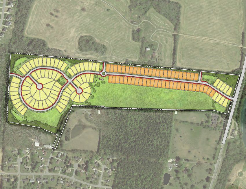
Applicant Information
Company Name:   NVR, INC
Attn:			Davis Lamb
Email:			dlamb@nvrinc.com
Mail Address:		 302 Innovation Drive, Franklin TN, 37067
			Suite 200

Engineer Information
Company Name:   PVE, LLC
Attn:			Grant Shiring
Phone:			(724)-444-1100
Email:			Gshiring@pve-llc.com
Mail Address:		 2000 Georgetown Drive, Sewickley PA, 15143
			Suite 101

Table of Contents

• Cover Page												(1)
• Table of Contents / Applicant Information							(2)
• Regional Site Context										(3)
• Zoning Analysis											(4)
• Major Thoroughfare Plan										(5)
• Structural / Use Analysis										(6)
• Hydrological Analysis										(7)
• Existing Conditions / Survey									(8-9)
• Concept Plan / Development Standards							(10-11)
• Lot Type / Sidewalk Exhibit									(12-13)
• Phasing Exhibit											(14-15)
• Open Space Exhibit											(16-17)
• Architectural Characteristics									(18-19)

PROLOGUE
TABLE OF CONTENTS                                 2.
Data Source: Google Maps

                                                                          Central Valley Rd

                                                                                                        US-231
                                                                                                 1
                                                                   Crusade R

                                                                                                US-23
                                                                            d

                                                                                                                 N

REGIONAL SITE CONTEXT                                                                         Not to Scale

• Address: 4871 Lebanon Pike                                     Subject Property             Murfreesboro
• Parcel ID: 047-073.00-000                                         Boundary                   City Limits

The subject property is situated within the County of Rutherford; North of the City of Murfreesboro,
just outside the regulatory limits of the City. Specifically located along US-231, the 57.0 Acre site
shall be subject to the most-recent regulations set forth by The Rutherford County Zoning Ordinance.
The Planned Unit Development shall consist of 137 single-family dwellings, for a proposed gross
density of 2.40 dwelling units per acre.

                                                                                                    PROLOGUE
                                                 3.                                           PROJECT SYNOPSIS
Data Source: Rutherford County Public Information App & City of Murfressboro Public GIS Mapping

                        MURFREESBORO
                        MUNICIPAL LIMIT

                                                                                                                N

ZONING ANALYSIS                                                                                      Not to Scale

Rutherford County Zoning Classification

                                                                                                   Subject Property
                                                                                                      Boundary

                                                                                                    Murfreesboro
                                                                                                  Municipal Boundary

City of Murfreesboro Zoning Classification            PRD         RS-10

Located just outside the Municipal Boundary of the City of Murfreesboro, the site is surrounded
by predominately residential land uses / zoning classifications. The subject site area is currently
classified as (RM) Medium Density Residential, which should create optimal conditions for the
proposed PUD development and ensure minimal conflicts with existing character within the area.

EXISTING CONDITIONS
ZONING ANALYSIS                                             4.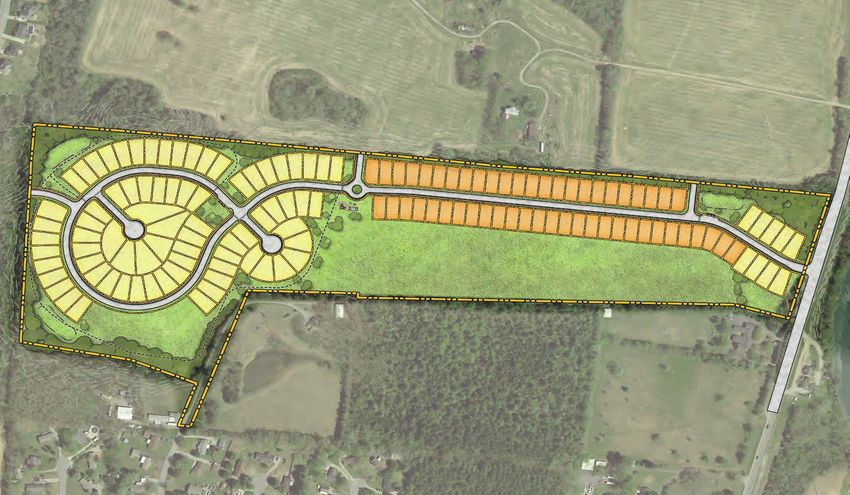
Data Source: Rutherford County Public Information App

                                                                                 N

LONG-RANGE TRANSPORTATION PLAN                                        Not to Scale

                     Safety Improvement

                     Two Lanes with Shoulders
                                                                    Subject Property
                                                                       Boundary
                     Three Lanes

                     Five Lanes

                                                                EXISTING CONDITIONS
                                                        5.   MAJOR THOROUGHFARE PLAN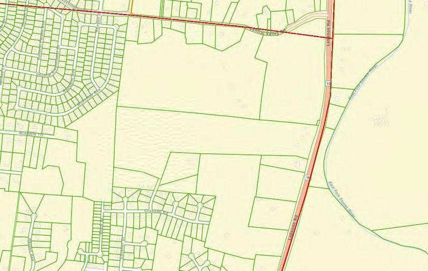
Data Source: Rutherford County Public Information App

                                                                2
                                                                                              3

                                                                                                     4
                                                                                                               5

                                                                    1

        13

                                                                                          7
                                                                                                         6
                                                  11

                        12
                                                       10                             8

                                                                                  9

                                                                                                              N

STRUCTURAL / USE ANALYSIS                                                                           Not to Scale

    Existing Building          Use ID Symbol                Adjoining Property
    and/or Structure          (See table below)             within 200’ of site
                                                                                                  Subject Property
                                     X                                                               Boundary

Lot No. Existing Structures                Identified Use
  1.         (3) Structures                6000 - Farm-Use
  2.         (4) Structures                6000 - Farm-Use
  3.         Unknown                       6000 - Farm-Use
  4.         Unknown                       9100 - Cemetery
  5.         Unknown                       1000 - Res Assess
  6.         (1) Structure                 1000 - Res Assess
  7.         (2) Structures                1000 - Res Assess
  8.         Unknown                       6000 - Farm-Use
  9.         (1) Structure                 7000 - Farm-Market
  10.        Unknown                       1000 - Res Assess
  11.        (2) Structures                1000 - Res Assess
  12.        (2) Structures                1000 - Res Assess
  13.        Unknown                       7000 - Farm-Market
EXISTING CONDITIONS
STRUCTURAL / USE ANALYSIS                                               6.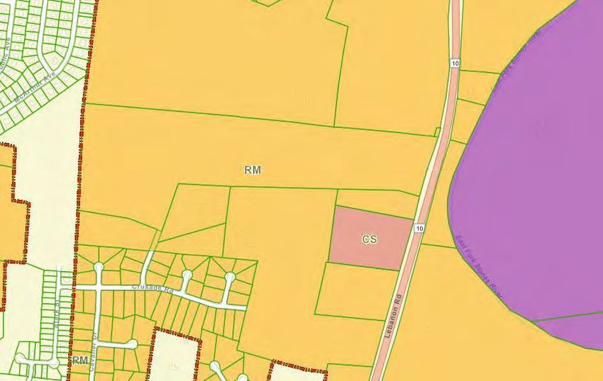
Data Source: Rutherford County Public Information App

                                                                      ZONE X

                                                                                                              N

      HYDROLOGICAL ANALYSIS                                                                        Not to Scale

                                                                                                 Subject Property
nuary 25, 2021                                                                                      Boundary

                                                                                                  Flow Direction
                                                                                                                     U
                                                                                                                     P
                                                                                                                     D
                                                                                                                     N

      Current Flood Hazard Zone: 		                  Zone X (Area of Minimal Flood Hazard)

      The graphic above demonstrates that the site is located within (Zone X), or Area of Minimal Flood
      Hazard Zone. No portion of this development is situated within any areas of FEMA Floodplain.

                                                                                             EXISTING CONDITIONS
                                                              7.                             HYDROLOGICAL ANALYSIS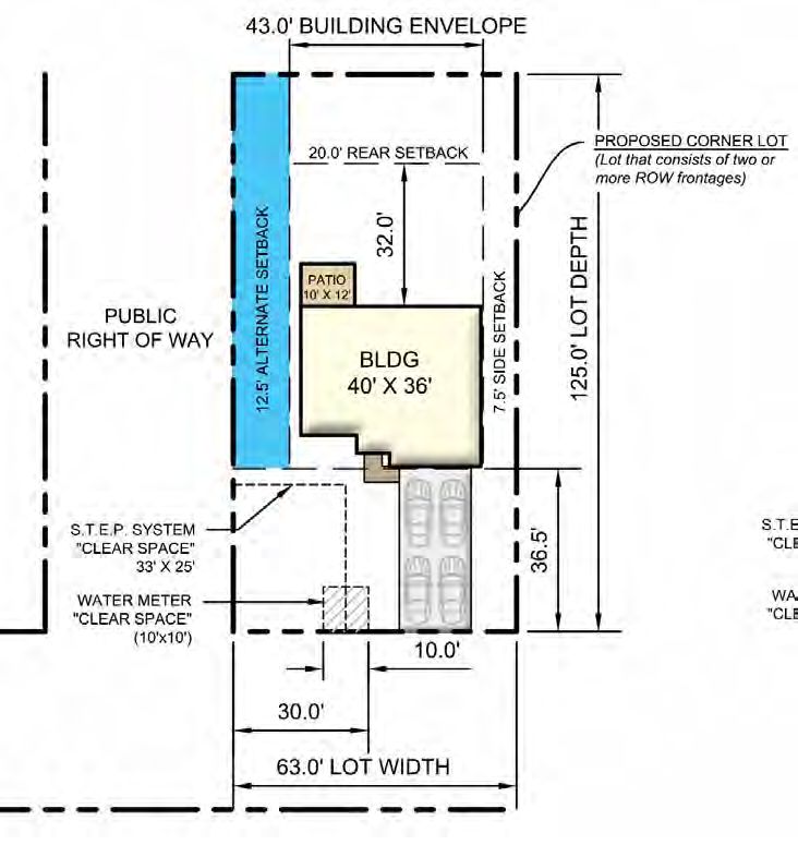
US-2
                           31

                                              N
                                   US-2
                                        31

                                                   d
                                                e Roa
                                                    d
                                              Crusa

                                Harle
                                     y Wa
                                          y

                                        Cavalier Dr.

EXISTING CONDITIONS
REFERENCE AERIAL      8.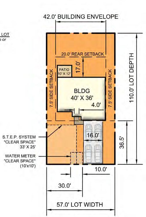
75’ WIDE                                                                              LEBANON PIKE
                                                                UTILITY EASEMENT                                                                                  (US-231)

                                                                                                                                             APPROX. LOCATION
                                                                                                                                            OF SEWER FORCE MAIN
                                                                                                                                            (CONDITION UNKNOWN)

                                               50’ WIDE
                                           ACCESS EASEMENT

                                                                                               20’ WIDE EASEMENT
                                                                                                   (Use Unknown)
                                                                                                                                                      EXISTING
                                                                                                                                                     OVERHEAD
                                                                                                                                                      UTILITIES

                                     EXISTING
                                    OVERHEAD
                                     UTILITIES

                                                         HARLEY WAY

                     Existing Overhead Electrical Line                  Existing Underground Sanitary Line              Existing Easement
                                                                                                                                             Total Site Area:            Subject Property
                                                                                                                                              57.01 Acres                   Boundary

EXISTING CONDITIONS
EXISTING CONDITIONS SURVEY                                                                                         9.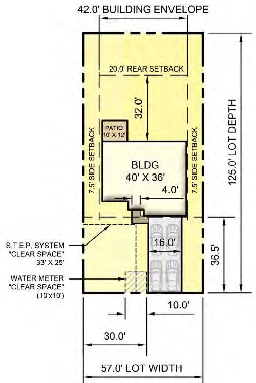
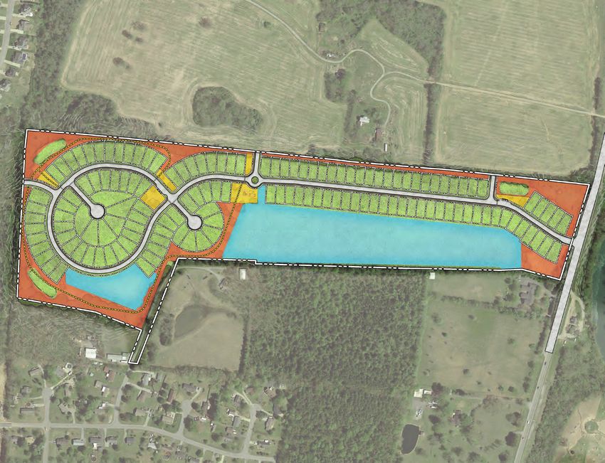
SEE LANDSCAPE
BUFFER NOTE
TRAIL
SYSTEM
FUTURE ROAD
ACTIVE OPEN CONNECTION
ter SPACE
m way 2
r t
StoFacili SEE LANDSCAPE
BUFFER NOTE FUTURE ROAD
CONNECTION
FUTURE ROAD ROAD 1
CONNECTION
C ROAD 1 C
Stormwater ACTIVE OPEN
C ACTIVE OPEN Facility 1 SPACE
RO
SPACE ROAD 1
AD
C C
C
2
RO
C ACTIVE OPEN
AD
SPACE & PARK EXCLUSIVE
3
50’ CUD ACCESS
EASEMENT
STEP SYSTEM
(APPROX.)
31
US-2
TRAIL
St SYSTEM
o SEE LANDSCAPE
Fa rm BUFFER NOTE
cil wa
ity te
3 r
STEP SYSTEM
(APPROX.)
SEE LANDSCAPE
BUFFER NOTE
C
Way
ley
Har
Crusade Road
Landscape Buffer Note:
Preserve existing vegetation in all areas where possible to satisfy the bufferyard requirements
specified in Rutherford County Zoning Code. A certified Arborist shall perform a site visit and TYP. CORNER LOT TYPE 1 LOT TYPE 2 LOT SINGLE-FAMILY UNIT
verify any potential locations where supplemental vegetation may be necessary. SIDEYARD SETBACK EXHIBIT LOT CONFIGURATION DETAIL LOT CONFIGURATION DETAIL TYPICAL UNIT DETAIL
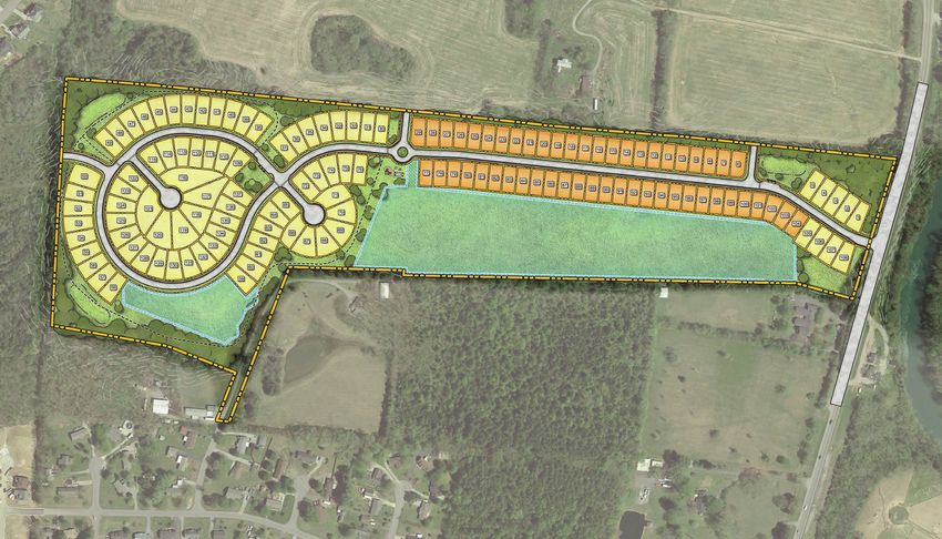
PROPOSED PLANNED UNIT DEVELOPMENT
CONCEPT SITE PLAN 10.PUD Established Development Standards:
Current Zoning: RM - (Medium Density Residential)
Proposed Zoning: PUD - (Intended for Residential Development)
Intended Development Type: Dwelling, Single Family
Gross Property Acreage: 57.01 Acres (±2,483,361 SF)
Development Standards Type 1 Lot Type 2 Lot
• Proposed Lot Totals: 52 Lots 85 Lots
• Typ. Unit Footprint: ±1,440 SF (See SFU Detail) ±1,440 SF (See SFU Detail)
• Max. Gross Floor Area per Unit: ±2,500 SF ±2,500 SF
• Min. Lot Area: 6,270 SF (57’ x 110’) 7,125 SF (57’ x 125’)
• Min. Lot Width: 57.0' 57.0'
• Max. Lot Coverage: 40% 40%
• Min. Front Yard Setback: 35.0’ 35.0’
• Min. Rear Yard Setback: 20.0’ 20.0’
• Min. Side Yard Setback: 15.0' Total (5' Min.) 15.0' Total (5' Min.)
1. Parking for residential units will comply with Rutherford County requirements
2. Each Single Family Dwelling shall contain Three to Four bedrooms
3. Each Single Family Dwelling shall provide parking as follows:
(Two Garage Parking Spaces & Four Driveway Parking Spaces - Total of Six)
4. All proposed streets will be designated as public ROW
5. All streets have been designed to comply with Rutherford County Subdivision regulations
6. All mail service shall be provided via CBU (See page 14-15)
7. All on-site utilities shall be installed underground
8. HVAC units shall be located to the rear or sides of each dwelling unit
9. Sanitary Sewer shall be handled via STEP System
10. All home owners will be required to join a Home Owners Association (HOA)
11. All common areas / amenity spaces shall be owned and maintained by HOA
12. The HOA shall be responsible for the continued maintenance of all common open spaces and governing the
use of facilities within. Details to be included within a Covenants & Restrictions document to be submitted
at a later date.
Existing Zoning Comparison:
Permitted Lots under (RM) Classification
• Min. Lot Area for (RM) district = 15,000 SF
• Total Site Area / Min. lot area for RM district = Max. allowable lots if 100% of site is developed
• 2,483,361 / 15,000 = 165.55 Permitted Lots
• 165.55 Permitted Lots / 57.01 Acres = 2.9 Allowed Gross DU/AC
Proposed Lots under (PUD) Classification
• Total Proposed Units = 137 Single-Family Dwellings
• Total Proposed Units / Total Site Area, in acres
• 137 Units / 57.01 Acres = 2.40 Proposed Gross DU/AC
Exclusive Residential Net Density Calculation
• Total Open Space Required = 6.54 AC
• Total Provided STEP Area = 13.39 AC
• 57.01 - (13.39 + 6.54) = 37.07 Acres 137 DU / 37.07 = 3.7 DU/AC
PROPOSED PLANNED UNIT DEVELOPMENT
11.
9. DEVELOPMENT STANDARDSN
PHASE 1
PHASE 2
PHASE 1
PHASE 2
PROPOSED PLANNED UNIT DEVELOPMENT
LOT TYPE / SIDEWALK EXHIBIT 10.
12.SYMBOL LEGEND
Type 1 Lot (52 Total Units)
Type 2 Lot (85 Total Units)
Provided (5’) Sidewalk (Provided as Shown)
As shown in the Lot Type / Sidewalk exhibit, a total of 137 dwelling units have been proposed with-
in the subject (PUD). A five (5.0’) sidewalk has been provided as shown across the site to promote
walkabillity and alternate forms of access to the amenities areas.
TYPICAL STREET SECTION
TYPICAL
STREET
4' 5' 2' 2' TYPICAL CARTWAY WIDTH: 24' 2' 11'
FRONT SETBACK: 35' TYP. RIGHT OF WAY: 50' FRONT SETBACK: 35' TYP.
PROPOSED PLANNED UNIT DEVELOPMENT
13.
11. LOT TYPE / SIDEWALK EXHIBITN
PHASE 1
PHASE 2
PHASE 1
PHASE 2
PROPOSED PLANNED UNIT DEVELOPMENT
PHASING EXHIBIT 12.
14.SYMBOL LEGEND
Open Space Total Provided: ±8.45 Acres
Usable Open Space Total Provided: ±2.52 Acres
S.T.E.P. System Area Total Provided: ±13.39 Acres
PHASING SUMMARY
PHASE 1 REQUIRED PROVIDED
• Est. Date of Construction: (N/A) (Winter / Spring 2022)
• Phase Area: (N/A) (±1,255,247 SF) or (28.8 AC)
• Proposed Units: (N/A) (61 Total Units)
• Lot Density: (N/A) (2.11 Gross DU/AC)
Additional provisions included in this phase include:
- 1 Stormwater Facility
- Active / Passive Open Space
- Cluster Mailbox Units (and 3 Provided Parking Spaces)
PHASE 2 REQUIRED PROVIDED
• Date of Construction: (N/A) (Summer / Fall 2022)
• Phase Area: (N/A) (±1,235,934 SF) or (28.3 AC)
• Proposed Units: (N/A) (76 Total Units)
• Lot Density: (N/A) (2.68 Gross DU/AC)
Additional provisions included in this phase include:
- 2 Stormwater Facilities
- Passive & Active Open Space
- Trail System
- Cluster Mailbox Units (and 3 Provided Parking Spaces)
PROPOSED PLANNED UNIT DEVELOPMENT
13.
15. PHASING EXHIBIT* LOCATION AND GRADE
LIMESTONE
WOOD CHIP SURFACE TO LIMESTONE
OF WOOD CHIP TRAIL TO
BE SELECTED BY OWNER BE FINALIZED IN FIELD
BY CONTRACTOR.
5.0'
OPEN SPACE EXHIBIT
6" MIN.
FILTER CLOTH REQUIRED
LIMESTONE TRAIL DETAIL
5
WOOD CHIP TRAIL DETAIL
PHASE 2
PHASE 1
NOT TO SCALE
1 5
PROPOSED PLANNED UNIT DEVELOPMENT
4
2 2 1
6
3 3 7
16.
14.
5
5
1 6
PHASE 2
PHASE 1
5
NOPEN SPACE SYMBOL LEGEND
"Any land or area within the boundaries of a development, the preservation of which in its present
use would: Conserve & enhance natural or scenic resources; Protect streams or water supply;
Open Space Promote the conservation of soils, wetlands or other environmentally sensitive areas; Enhance
the value to the public of abutting or neighboring parks, forests, wildlife preserves, nature
reservations or sanctuaries; or Enhance recreation opportunities" (§902.k.2.a)
"An area or areas within the boundaries of a development that are designed, set aside,
Usable Open Space and maintained for either passive or active recreation, and are available for the use of all
residents of the development" (§902.k.2.b)
OPEN SPACE SUMMARY REQUIRED PROVIDED
• Open Space: (190,006 SF) or (4.36 AC) (± 368,182 SF) or (± 8.45 AC)
• Usable Open Space: (95,003 SF) or (2.18 AC) (± 109,820 SF) or (± 2.52 AC)
Required Open Space Calculation:
([Gross Project Area] - [STEP System Area] x [10%] = Required Open Space)
([2,483,361] - [583,293] = [1,900,068] x [0.10] = [190,006 SF] or [4.36 AC])
Required Usable Open Space Calculation:
([Required Open Space] x [50%] = Required Usable Open Space)
([190,006] x [0.50] = [95,003 SF] or [2.18 AC])
AMENITIES SYMBOL LEGEND
1 Stormwater Facility
2 Cluster Mailbox Unit & Provided Parallel Parking (3 Spaces)
3 Park / Open Lawn
4 Playground (Commercial Grade)
5 Provided Bufferyard (See Page 10 for more information)
6 5' Wide Limestone Trail System
7 50' Wide Exclusive CUD STEP Access
Simply Ryan Communities are ideally
setup using Cluster Boxes (CBU’s) for
mail delivery.
Improved street and community appeal
Mail Security
Required By USPS in many “Urban” designated areas
Reduced cost per Home vs Individual Mailboxes
Site Plans should incorporate CBU loca-
tions and take a planned approach prior
to install.
Multiple CBU locations will be common
and preferred in Simply Ryan communi-
ties based on convenience and commu-
nity layout. Simply Ryan jobs often do
not have the required open space area
needed to install multiple units on a cen-
Example of Playground
tral site. Example of CBU Example of Limestone Trail
PROPOSED PLANNED UNIT DEVELOPMENT
15.
17. OPEN SPACE EXHIBIT*Example of Typical Single-Family Dwelling Floorplan
*Provided graphic demonstrates an example of one housing option proposed within this development.
Alternative housing options and layouts shall be made available to prospective buyers.
Upper Level
Main Level
PROPOSED PLANNED UNIT DEVELOPMENT
ARCHITECTURAL CHARACTERISTICS 16.
18.Architectural Characteristics
• Building Heights shall comply with the requirements set forth for (RM) Zoning of (35’ Max.)
• All proposed dwellings shall be maximum of two stories
• All proposed dwellings shall contain a minimum of three; and a maximum of four bedrooms
• Typical Unit Footprint: (See Page 11)
• Maximum Lot Coverage: (See Page 11)
• Typical Dwelling Size: (See Page 11)
Material Characteristics
Proposed Building Materials may differ dependent on the housing option chosen by the prospective tenants.
All units shall utilize a mixture of the following materials to create a cohesive neighborhood character:
~ Hardi Siding & Vinyl Accents
~ Stone Water Table
*Architectural Renderings Monument Entry Sign
PROPOSED PLANNED UNIT DEVELOPMENT
17.
19. ARCHITECTURAL CHARACTERISTICSNVR - IRWIN PROPERTY
PLANNED UNIT DEVELOPMENT
- REGULATING PATTERN BOOK -
Submission Date:
• December 15th, 2020
Revision Date:
• January 28th, 2021
• March 25th, 2021
• July 13th, 2021
• August 6th, 2021
© Copyright 2021, PVE Engineering, LLCYou can also read