ParcelMap BC Adoption Working Group Land Records Integration Workshop
←
→
Page content transcription
If your browser does not render page correctly, please read the page content below

ParcelMap BC Adoption Working Group
         Land Records Integration Workshop

AWG #28: Open House      Brian Greening   AWG Chair
                                          Director, ParcelMap BC Products, LTSA
   May 19th 2021
10:00am to 12:00 pm      Steve Mark       AWG Vice-Chair
                                          Director of Operations, ICI Society
   Remote Session
                                          ©2021 Land Title and Survey Authority of British Columbia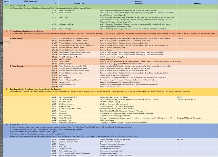
Agenda
Welcome / Opening Remarks (10 min)                                                                                                                                          10:00 am
BC Assessment Fabric: (15 min) - Tom O’Brien, BC Assessment
•      Assessment Fabric Data Model                                                                                                                                         10:10 am
•      ParcelMap BC & the Assessment Fabric: Which should I use and when?
First Looks at Integrating ParcelMapBC and Tempest with Scripts and Databases : (15 min) - Brian Goble, District of Sooke
•      Overview of Python scripts to explore linking Tempest Land records to ParcelMapBC parcel records                                                                     10:25 am
•      Overview of relating Tempest Land records to GIS ParcelMapBC records in SQL databases
Integration of ParcelMap BC with Land Records through Esri Web Apps: (15 min) - Jason Hart, Harterra Spatial Solutions
•      A look at real-world examples of different patterns and approaches for integrating ParcelMapBC and Tempest or other Land Records systems through ArcGIS
       Enterprise and Web AppBuilder
                                                                                                                                                                            10:40 am
•      Using change detection for data loading into an Enterprise Geodatabase to avoid administrative headaches and to provide a his tory of parcel changes over time
Integrating ParcelMap BC with iCity/Vadim: (10 min) - Barry McLane, City of Rossland
                                                                                                                                                                            10:55 am
•      ParcelMap BC/iCity integration using ArcGIS Pro
Land Records Resources & ICI Society’s Collaboration Portal: (5 min) - Steve Mark, ICI Society
•      Resources available to ICI Society Members for ParcelMap BC
•      Best Practices                                                                                                                                                       11:05 am
•      Documentation
•      Forum to post ParcelMap BC related Questions
Fitting the Pieces Together: Land Records Integration & Transition Planning: (15 min) - Irshad Jamal, LTSA & John Samulski, LTSA/SVG
•      Land Records Integration Within Overall Transition to ParcelMap BC                                                                                                   11:10 am
•      Available Resources and Their Function Within Transition Planning and Execution
Questions, Feedback & Presentation Wrap-Up (5 min)                                                                                                                          11:25 am
Open Café/Cocktail Discussion (30 min)                                                                                                                                      11:30 am

                                                                                                                                                    ©2021 Land Title and Survey Authority of British Columbia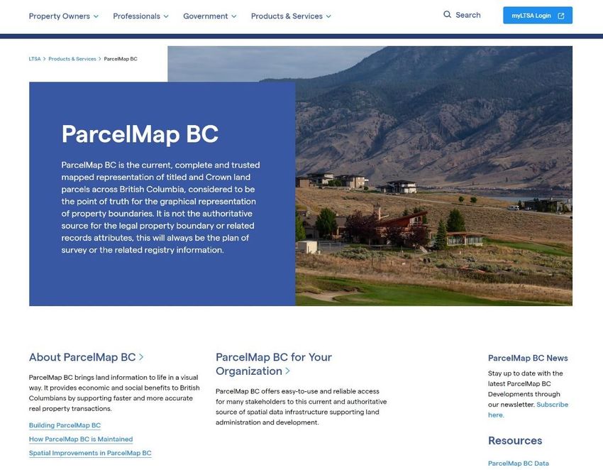
ParcelMap BC Adoption
       Snapshot

    Full Dashboard
      details here
                           LIVE map
                         Green = Adopted
                        Blue = Transitioning

                                               ©2021 Land Title and Survey Authority of British Columbia
ParcelMap BC Adoption Working Group (AWG)
AWG created in mid-2018 in conjunction with the ICI Society as a
forum to address issues related to the adoption of ParcelMap BC.

~30 participants including local governments, provincial ministries,
land surveyors, utilities and other stakeholders
Highlights of achievements include:
• Improved product documentation and associated resources
• Alignment of key 3rd party maintained datasets, including the Agricultural Land Reserve (ALR)
  boundaries and BCA’s Assessment Fabric;
• Creation of the Data Alignment Sub-Group, aimed at developing workflows and tools to support
  aligning data with ParcelMap BC;
• New resources, including an app, to publicly share operational plans and progress related to
  spatial improvements
• Development of Transition Planning Resources to facilitate activities related to adopting
  ParcelMap BC
• Creation of the Land Records Sub-Group, focused on the integration of ParcelMap
  BC with land records systems…

                                                                                                  ©2021 Land Title and Survey Authority of British Columbia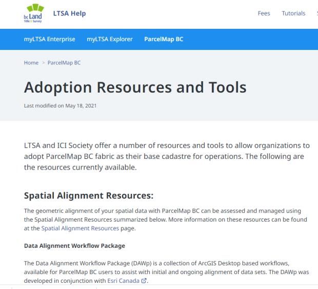
ParcelMap BC Adoption & Land Records Integration
Background / Introduction:
A key focus area identified by the AWG was the need to support linkages between ParcelMap BC parcel records
and various Land Records data management environments maintained within the various Adopter organisations.

A poll of the Adopter community revealed that while Tempest dominates the install base within the Local
Government Adopter community, there is significant representation of other platforms such as iCity/Vadim and
Diamond.

A number of resources have been developed by the “Team Land Records” subgroup to support linking ParcelMap
BC with local Land Records management data and maintaining those linkages.

  This workshop is a showcase for those resources to raise awareness and promote use of these
                resources among the larger ParcelMap BC Adopter community.

                                                                                    ©2021 Land Title and Survey Authority of British Columbia
Assessment Fabric
and Data Advice

Tom O’Brien, Senior GIS Analyst
May 19, 2021
Assessment Fabric

• Created from multiple sources

• Georeferenced with BC Assessment folios – roll number

• Provides a roll based spatial representation of the properties

• Often times is many to one relationship with source spatial data
     • Example – Many PID’s to one roll number
     • Example – Many crown tenure polygons to one roll number

• Shared through ICI Society membership
Assessment Fabric
Spatial Data Sources

• Parcel Map BC

• ICI Society Cadastre

• NRCAN – First Nations Parcels

• Crown Tenures

• Survey Parcels

•  internal only

• Some other sources too…

Data Advice

          • Provided to local governments as a data file

          • Formatted to be compatible with land records systems (Vadim,
              Tempest, etc.)

          • Not designed for ease of use with GIS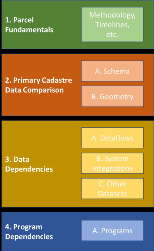
What we are interested in…

          • Is the Data Advice or Land Records data more easily related to the
            Assessment Fabric due to the roll based nature of both products?

                                                                         Data Advice
                                                                             or
                                                      Roll #          Land Records Data

                             Assessment Fabric
First Looks at Integrating ParcelMapBC and
Tempest with Scripts and Databases
Brian Goble, District of Sooke
©2021 Land Title and Survey Authority of British ColumbiaPython Script linking ParcelMapBC
with Tempest Land Records
Input Tables:
1. Tempest.Land_Legal
2. PMBC Jurol_PID_X_Reference
3. PMBC Parcel_Polygon
4. PMBC Shared_Geometry
5. PMBC Plans
Output Table: TempestLinkTempestLink Look-Up Table Field Type Source Comments PropertyNumber Long Integer Tempest Property Number Optional. Tempest system generated value. GISLINK Long Integer Tempest Map Reference Required for the Web Map integration with Tempest Land. Folio Text PMBC Jurol_PID_X_Reference BC Assessment Roll Number – In PMBC, only available for PID PID Text PMBC Jurol_PID_X_Reference Not all properties have PIDs (e.g., Park, Road). Plan Text Tempest Plan From Tempest. Used to update link to Shared Geometry records pmbcParcelID GUID PMBC GlobalID KEY to linking Tempest Record to a PMBC polygon. pmbcPlanID Long Integer PMBC PlanID Used to update link to Shared Geometry records pmbcDescription Text PMBC LegalDescription Optional. Used to validate results. tempestLegalID Text Tempest Land Legal ID Tempest ID for Tempest.Land_Legal records. Relates to other tables.
Update TempestLink Script (Python)
                                                                                        • Processed 9,530 TempestLink records in 17 minutes.
Executing: Script-TempestLandLegalUpdate

Start Time: Mon May 17 09:25:44 2021

Running script Script-TempestLandLegalUpdate...

Purging old Tempest Land Legal Table records...
                                                                                        • The TempestLink table includes all records from ParcelMap BC
Appending Tempest Land Legal Table from
Records = 8708
                                                                                          regardless of Municipality/Jurisdiction.
Purging old Tempest Link Table records...

Appending PMBC Parcel Polygons to TempestLink table...
Records in Parcel Polygon = 7923

Appending PMBC Shared Geometry to TempestLinktable ...
                                                                                        • Challenges for Linking:
Records in Shared Geometry = 1607
                                                                                           • Dedicated Parks with multiple parcel land records
                                                                                           • Dedicated Roads (historical) not recorded in PMBC
Updating TempestLink.Folio from pmbcJurol_PID_X_Referencetable ...
Updating TempestLink.Plan from pmbcPlans table ...
Updating TempestLink.GISLINK from pmbcTempestLandLegal table ...
Updating TempestLink.GISLINK for PARKS from pmbcTempestLandLegal table ...
Updating TempestLink.GISLINK for STRATA COMMON PROPERTY from pmbcTempestLandLegal ...
Updating TempestLink.GISLINK for RETURN TO CROWN from pmbcTempestLandLegal table ...
                                                                                           • Different representations of Strata in PMBC and GIS
Updating TempestLink.GISLINK for matching PID from pmbcTempestLandLegal table ...
Flagging TempestLink.GISLINK for Strata Plans from pmbcTempestLandLegal ...
Updating TempestLink.pmbcParcelGUID from pmbcParcelPolygon table for Strata Lots ...

Summarizing TempestLink.GISLINK for Folios...
 Total Records in TempestLink= 9530
  NULL Folio Records = 1198
  NULL GISLINK Records = 3042

--- Finished ---

Completed script Script-TempestLandLegalUpdate...

Succeeded at Mon May 17 09:43:14 2021 (Elapsed Time: 17 minutes 30 seconds)
Proposed SQL Database Views
Tempest Land GISLINK GIS Parcels Tempest
Application List [GISLINK] Web Map App
SQL Database
TempestLink Table
( GISLINK; PMBC ID)
ParcelMap BC
Tempest ParcelMap BC
Shared
Land Legal Parcels
GeometryIntegration of ParcelMap BC
with Land Records Systems
through Esri Web Apps
May 19, 2021
Jason Hart
Owner /GIS Specialist
jason.hart@harterra.comPatterns to Integrating Land Systems and GIS Common approaches we have used with clients
ELT Approach
Database level extract, load and
transformation (ELT)
   • Using scripts and/or tools (SQL,
     data base links, Python, FME) to
     move data from Lands System
     into GIS tables.
   • May be a relational data
     structure.                         Parcel   Te mpest Land Legal
                                                                                 P arcel

   • Tools may be used to flatten                                      S trata

     data or relate lands data to
     ParcelMap BC Parcels or to BC
     Assessment.
Using an ELT Approach in Web Appbuilder
• Publish GIS data (including that from the lands system) as a service
through ArcGIS Enterprise
• Two options to use in Web Appbuilder:
• Out-of-box
• Flattened data (single table) is better
• Use tools like the public notification widget and standard pop-ups
• Purpose built widget
• Widget understands the data and structure
• Presents data so people see and navigate the structure easily and efficiently
• Has behaviours that allow users to navigate data easilyPros and Cons of ELT Approach • Cons: • Lots of moving parts and duplication of data • Hard to really get working nicely with just out-of-the-box tools • Pros: • Use data in desktop, mobile and web GIS tools • Gives users access to data at their finger-tips
Pushing Parcels of Interest Approach
• This doesn’t involve moving data                       Tempest
  between systems, rather parcels of                                                    Esri
                                                          Client                   Web Appbuilder
  interest (details on the selected
  records)                                              Application
   • This is an approach we use for Tempest                           Show on
                                                                       Map
     not Vadim
   • Pushes and pulls GISLINK field for                                  Query
     selected parcels between Tempest and                               Selected
     GIS
   • Relies on …
      •   Built-in Tempest functionality
      •   Custom tool to open a web browser
      •   Custom widget in Web Appbuilder
      •   GISLINKs to be populated in Tempest and GIS
Using a Parcel selection wih Web Appbuilder
• Publish as a service through ArcGIS Enterprise
• Link to Tempest database tables using ArcGIS Server to allow data to be
accessed through REST service
• one that is read-only (GIS Layer and Land Legal Tables)
• one that is read/write (Session Details) for pushing selected parcel identifiers
• Use custom widget to handle selection interaction
• Displaying selected properties pushed from Tempest on opening of Web App
• Selection of parcels
• Pushing parcels selected into the Session table when the selection changes in
Web AppbuilderUsing a Parcel selection with Web Appbuilder
• Widget handles updates to session details table in Tempest through
R/W REST Service including:
• 1..M between Tempest tables and ParcelMap BC Parcels.
• M..M between Tempest tables and ParcelMap BC Parcels using “joining”
table
• Requires GISLINK populated in Tempest and GISPushing Parcels of Interest Approach Example
Pros and Cons of Pushing Parcels of Interest
Approach
• Cons:
   • No Tempest data is available in GIS for other purposes (mapping, queries)
   • Requires a custom DLL to open Web Appbuilder in Tempest

• Pros:
   • Allows users to perform other workflows in Tempest on selected parcels
      • Example: notifications
   • No Tempest needs to be migrated into or duplicated in the GIS database
Loading ParcelMap BC Into Enterprise Approaches to loading data into an esri Enterprise Geodatabase
Drop and Copy
• Drop or delete the local feature              GeoShare
  classes and tables and copy the               Package
  latest ParcelMap BC feature classes                               Copy Tables
  and tables into your database
   • Pros:
       • Automatically get ParcelMap schema                          and Data
         changes
       • Simple to do manually or with simple
         tools that are not too complex
                                                           Delete
   • Cons:
       • Any service or applications must be
         disconnected (requires exclusive
         schema lock)                                      Tables
       • Value add attributes or related          Local
         information must be repopulated or
         re-linked.                             Database
       • GlobalIDs and ObjectIDs change
Truncate and Append
• Truncate (delete) all the rows in the
Source Parcel
local feature classes and tables and re-
insert the records from ParcelMap BC
• Pros:
• Services or app connections do not need
to be disconnected (no exclusive schema
lock)
• Simple to do manually or with simple
scripts
• Cons:
Append Truncate
• Value add attributes or related information
must be repopulated or re-linked Relate Data
Local Parcel
• Slower to insert data into existing data
• Has impacts on database
• Schema doesn’t change automatically with
ParcelMap BC
• Theoretically could run out of ObjectIDs
• History (archiving) could get large
• GlobalIDs and ObjectIDs change for the
same parcelDetect Changes and Update
• Compare your local feature classes and
Source Parcel
tables to ParcelMap BC package from ICI
Society and update attributes/shapes,
delete or insert new parcels.
• Pros:
• Services or app connections do not need to
be disconnected (no exclusive schema lock)
• Value add attributes or related information
do not have to repopulated or re-linked
• Detecting changes allows for automated
notification. (i.e. a new parcel has arrived)
• Allows you to more realistically keep a
history (archive) of all the changes Relate Data
Local Parcel
• You can have your own cycle to your updates
(can skip a package)
• Cons:
• Can get really slow if ParcelMap BC changes
a lot of things (spatial improvements)
• Schema doesn’t change automatically with
ParcelMap BCApproaches Compared to Change Detection
• Real-world example of change detection Week Parcels Parcels Parcels Execution
approach Removed Added Changed Time (m:s)
• On a set of approximately 23,000 parcels polygons
with weekly updates 05/15/2021 4 9 29 04:24
• Since 2018 there have been around 2.1 million** 05/08/2021 8 46 62 03:57
changes (attributes, inserts, shape changes) to
parcels 05/01/2021 0 0 0 03:38
• Since January 1, 2021 only 1,044 changes… so we 04/24/2021 4 5 30 03:54
would expect this to be typically on the order of
1000’s or perhaps 10,000’s of changes per year 04/17/2021 0 1 6 03:42
04/10/2021 0 0 5 03:38
• Truncation/deletion and appending records
• 5.9 million deletes and inserts. Week Parcels Parcels Parcels Execution
Removed Added Changed Time (m:s)
• Dropping /deleting feature classes and tables 05/15/2021 4 9 29 04:24
• The tables dropped and recreated 129 times 05/08/2021 8 46 62 03:57
• 3 million rows copied and inserted 01/04/2020 0 0 22389 26:33
** High number likely most due to early changes where things were getting changed regularly and during early days of PMBC and the change management toolsGDB Archiving of ParcelMap BC
• Using archiving (history) on the geodatabase and change detection
approach to updates provides insights and supports…
• Workflows for alignment of local
datasets with ParcelMap BC
• Systems integration
• Issue resolution to parcel changes
• And so much moreQuestions?
Jason Hart
Owner / GIS Specialist
250.608.1335
jason.hart@harterra.comIntegrating ParcelMap BC with iCity/Vadim
Barry McLane, City of Rossland
©2021 Land Title and Survey Authority of British ColumbiaPMBC – iCity Relationship Model
PMBC_PARCEL_POLYGO
PMBC
PMBC_ROSSLAND.gdb N
PlanID / LinkedPlanID
Legend
PMBC_SHARED_GEOMETR
JUROL_PID_X_REFERENCE
PID Y 1:Many
1:1
Roll # Roll # Roll # Roll # Database
Feature
Assessment Folio Property Tax Ownership
Class
iCity
Table
iCitySQLServerConnection.sdeiCity Database Connection (ArcGIS Pro)
Whitelist your GIS’s local IP address with the hosted
environment
IP Address →
iCity Credentials →
iCity Credentials →
Live Database →PT_ASSESSMENT PT_FOLIO v_pt_trans_smry V_CS_PROPERTY_MAILING_ADDR
Thanks for hosting!
Land Records Resources & ICI Society’s
        Collaboration Portal
       Steve Mark, ICI Society

                                ©2021 Land Title and Survey Authority of British Columbia
Collaboration
Portal
• Share Ideas
• Best Practices
• Meta-Data
• User Forum
40PMBC
Resources
• Virtual Cafe
• PMBC Links
• ICI Society Member - Metadata
41ICI Society
Data Packages
• PMBC Data
• Utilities Data
• Customized Deliveries
• Real World Changes
• Weekly re-fresh
42Fitting the Pieces Together: Land Records
Integration & Transition Planning
Irshad Jamal, LTSA & John Samulski, LTSA/SVG
©2021 Land Title and Survey Authority of British ColumbiaLand Records Integration and Transition Planning
A little more background…
• In 2020 a Large Municipality Focus Group (LMFG) was established to examine issues associated with large
municipality Adoption of ParcelMap BC. (City of Vancouver, City of Surrey, City of Burnaby, District of North Vancouver,
Township of Langley, City of Kamloops*)
• All LMFG participants have mature Land Records system(s) with one or more integrations to their current
parcel fabric which must be maintained.
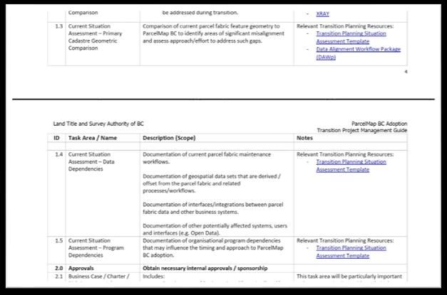
• One of the outputs of the LMFG effort is a Transition Project Management Guide has been developed by
LTSA to assist organisations with planning and execution of their Transition to ParcelMap BC adoption.
Where do the Land Records Integration resources fit in my Transition to ParcelMap
BC adoption?
• Recommended Transition activities in the guide are broken into two phases: Planning & Execution.
• A key Task Area of the Planning Phase is a detailed Situation Assessment, which includes integrations and
interfaces between the Parcel Fabric and Land Records systems and data.
©2021 Land Title and Survey Authority of British ColumbiaTransition Project Management Guide
©2021 Land Title and Survey Authority of British ColumbiaTransition Project Management Guide - WBS
©2021 Land Title and Survey Authority of British ColumbiaTransition Steps:
Key Transition Steps and Milestones:
Phase 1: Project Planning
Key Areas to Apply Land Records Resources
1.0 Current
2.0 3.0 Project
Situation
Assessment Approvals Planning Phase 2: Project Execution
4.0 Project Management
5.0 LG Parcel Data / 6.0 Parcel Fabric 7.0 Land
ParcelMap BC / Land Records Records System
Realignment Process Update Integrations
8.0 Asset
Management /
Work Order System
“Substantial Adoption” Integrations
9.0 Other
Integrations /
Interfaces
Incumbent Local Parcel Fabric Data Use Realisation of Benefits
“Substantial Adoption” is achieved when ParcelMap BC data supersedes the incumbent self-maintained
parcel fabric data as the primary source for truth for the geometric representation of parcel features.
©2021 Land Title and Survey Authority of British ColumbiaSituation Assessment Template Thematic Areas
©2021 Land Title and Survey Authority of British ColumbiaSituation Assessment Template - Details
©2021 Land Title and Survey Authority of British ColumbiaLand Records Adoption Resources (LTSA.CA)
©2021 Land Title and Survey Authority of British ColumbiaLand Records Adoption Resources Links
Portal to the Adoption Resources
Adoption Resources and Tools
©2021 Land Title and Survey Authority of British ColumbiaPresentation Wrap-Up & Further Questions
General / Data Inquiries: ParcelMapBC@ltsa.ca
Sign up for the ParcelMap BC Newsletter!
https://ltsa.ca/contact-us/subscribe-to-ltsa-communications/
©2021 Land Title and Survey Authority of British ColumbiaOpen Café/Cocktail Discussion
Continue the conversation!
Please “raise your hand” or type in the chat if you
have any ParcelMap BC questions for the
presenters, the LTSA, ICI Society or your peers
©2021 Land Title and Survey Authority of British ColumbiaYou can also read