GUIDANCE DOCUMENT LEASE PLAN OF OPERATIONS APPLICATION - Alaska ...
←
→
Page content transcription
If your browser does not render page correctly, please read the page content below
GUIDANCE DOCUMENT
                              LEASE PLAN OF OPERATIONS APPLICATION
                                                               State of Alaska
                                           Department of Natural Resources, Division of Oil and Gas
                                           550 W. 7th Ave, Suite 1100, Anchorage, AK 99501-3563
                                                  Phone: 907-269-8800 Fax: 907-269-8943
                                                Permitting Email: dog.permitting@alaska.gov

REQUIREMENTS FOR THE PLAN OF OPERATIONS                                                                                   11 AAC 83.158

The State of Alaska (State), Division of Oil and Gas (Division) manages activities related to oil and gas on State land to minimize adverse
effects on the land and its resources.
A lease gives the lessee the right to the leased area for exploration, development, and production activities. It does not authorize
operations or any specific activities. A Lease Plan of Operations Application (Application) must be submitted, reviewed and approved
before any operations can begin on or in the lease area; if no exploration or production is going to occur from a State of Alaska Oil and
Gas lease managed by the Division contact the Division Permitting Staff prior to beginning the application to determine applicability and
jurisdiction. The approved Application provides the authority to begin operations on or in the lease area.

The information in the application must meet two goals:
    • Provide sufficient information related to the project, the project area and proposed operations for the Division to determine the
         surface use requirements and impacts directly associated with the proposed operations on or in the lease.
    • Present information about proposed oil and gas operations in a format that is clear and understandable.
Any application which does not meet the goals listed above will not meet the minimum requirements for review.

GENERAL INSTRUCTIONS

1. Ensure that you are using the correct version of the Lease Plan of Operations Application Form. The correct version is available on
   the Division of Oil and Gas: http://dog.dnr.alaska.gov/Services/Applications
2. Answer all questions. If not applicable, to be determined, none-identified or other answer is appropriate, indicate so.
3. A complete application packet includes:
    • Application and appendices
    • Filing fee
4. Deliver completed applications to the address above or email to the Division’s Permitting Section at: dog.permitting@alaska.gov
FILING FEE                                                                                                                11 AAC 05.110

    The filing fee should be:
        • $750.00
        • Check or money order made out to State of Alaska, DNR, DOG
        • Delivered to the Division of Oil and Gas Permitting Section

SECTION I: APPLICANT INFORMATION                                                                                       11 AAC 83.158 (d)

1. Provide the name, mailing address, phone number, fax, and email of the applicant. Multiple phone numbers may be entered in the
   phone number field.
    The applicant must be an entity qualified and licensed to conduct business in Alaska and must possess the authority to undertake
    the work described in the application. The applicant is the responsible entity for the project.
2. Provide the name, mailing address, phone number, fax, and email of the applicant’s contact. Multiple phone numbers may be entered
   in the phone number field.

       Lease Plan of Operations Guidance Document V2.1                                                              Page 1 of 11
       Revised 10/25/2018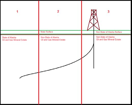
The applicant’s contact must be an individual authorized to speak on behalf of the applicant and serve as the main point of contact
     for permitting questions and other project details. Consultants and contractors should not be listed here.

SECTION II: 3RD PARTY INFORMATION                                                                                          11 AAC 83.158 (d)
     This section should be used when the applicant and the applicant’s contact are not the entity or person preparing the application.
     This commonly occurs with consultants and contractors. Provide the name, mailing address, phone number, fax, and email of the
     3rd party. Multiple phone numbers may be entered in the phone number field.
SECTION III: APPLICATION DATE AND NUMBER                                                                                   11 AAC 83.158 (d)
     Leave this section blank. This section is to be filled out by the Division’s Permitting Section.
SECTION IV: PROJECT INFORMATION                                                                                            11 AAC 83.158 (d)
1. Enter the project name (name designated by applicant for the project).
2. Enter the proposed start date for the project (this date is determined by initiation of operations for which this authorization is required.)
3. Provide a brief description of your project in paragraph form:
       a. What: what the project will entail, project components (i.e. ice/gravel pad/road, pipelines) and what the objectives are (i.e.
            exploration, delineation, production);
       b. Where: describe where the project is to occur and describe existing facilities, landmarks populated areas or nearby
            infrastructure.
SECTION V: LAND STATUS                                                                                            11 AAC 83.158 (a) and (d)
Provide land status of the project area. The Division evaluates the land status of lands affected by the project and project components.
Consequently this section uses the location of project components to determine the lands included in the application. For this
application, Land Status is divided into three mutually exclusive subsections: 1. State Mineral Estate; 2. State of Alaska Surface Lands
and; 3. Non-State Lands. The below diagrams depict each subsection and the criteria necessary for land to be included in the
appropriate subsection.

1.   State Mineral Estate:

     This section is organized by using the State of Alaska, Alaska Division of Lands (ADL) Oil and Gas lease number. This section is
     defined by the State of Alaska having rights to the Oil and Gas mineral estate, within a Unit, as depicted in the Figure 1: State
     Mineral Estate. As depicted the criterion for lands to qualify for inclusion is the presence of a State of Alaska Oil and Gas Lease.
     Surface ownership has no part in determining if lands qualify for this subsection. Note the surface land owner and the surface and
     subsurface project components must be listed in the Plan Application under Section V Subsection 1. State Mineral Estate in the
     space provided.

        Lease Plan of Operations Guidance Document V2.1                                                                 Page 2 of 11
        Revised 10/25/2018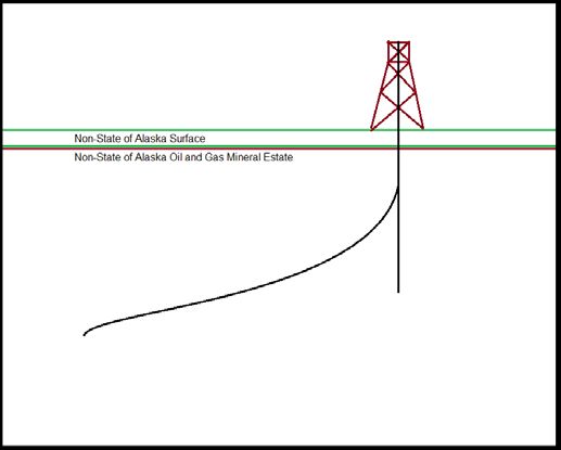
Figure 1: State Mineral Estate

2. State of Alaska Surface Lands:

   This section addresses oil and gas activities, within a Unit, located on State of Alaska Surface Lands where the oil and gas mineral
   estate below those surface lands is not owned by the State of Alaska (split estate: state surface and non-state oil and gas mineral
   estate) as depicted in the below diagram (Figure 2: State of Alaska Surface Lands). Any lands discussed in subsection “1. State
   Mineral Estate” do not qualify under this subsection.

                                                Figure 2: State of Alaska Surface Lands

3. Non-State Lands:

   This section addresses oil and gas activities, within a Unit, located on Non-State Lands; surface and oil and gas mineral estate as
   depicted in the below diagram (Figure 2: Non-State Lands). Any lands discussed in subsections “1. State Mineral Estate” and
   “2. State of Alaska Surface Lands” do not qualify under this subsection.

      Lease Plan of Operations Guidance Document V2.1                                                           Page 3 of 11
      Revised 10/25/2018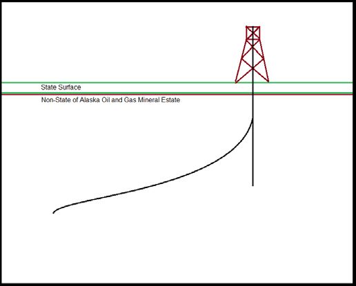
Figure 3: Non-State Lands

The below diagram (Figure 4: Sample Project Land Status by Project Component) illustrates a project which includes all Land Status
subsection: State of Alaska Mineral Estate; State of Alaska Surface Lands; and Non-State Lands. The explanation below the Figure
4 demonstrates what project components should be reported in each Land Status subsection on the Plan application.

                                    Figure 4: Sample Project Land Status by Project Component

The diagram above, Sample Project Land Status by Project Component, is designed to provide an example of how to correctly
complete Section V. Land Status on a Plan application. The diagram is separated into three numbered columns by two vertical red
lines. The number of the column corresponds to the Land Status subsection to which the project components should be reported in
the application.
Column 1 represents subsection 1. State Mineral Estate. The criterion for lands to be included in this section is that an oil and gas
ADL number exists for the mineral estate. Surface ownership has no part in determining if lands qualify for this section. Consequently
the project components listed in subsection 1. State Mineral Estate on the application will include a wellbore and a production zone.
Column 2 represents subsection 2. State of Alaska Surface Lands. The criteria for lands to be included in this section are: the State
of Alaska owns the surface land and; the oil and gas mineral estate underneath those surface lands is not owned by the State of
Alaska (no oil and gas ADL number exists). Consequently the project components listed in subsection 2. State of Alaska Surface
Lands on the application will include a wellbore.

   Lease Plan of Operations Guidance Document V2.1                                                             Page 4 of 11
   Revised 10/25/2018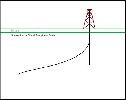
Column 3 represents subsection 3. Non-State Lands. The criteria for lands to be included in this section are: the State of Alaska
    does not own the surface land and; the oil and gas mineral estate is not owned by the State of Alaska. Consequently the project
    components listed in subsection 3. Non-State Lands on the application will include wellbores, production zone and surface facilities.
Below are instructions outlining the information needed for each Subsection.
1. State Mineral Estate:

    This section is defined by the State of Alaska having rights to the Oil and Gas mineral estate, within a Unit, as depicted in the
    below diagram.

    This section is organized by using the State of Alaska, Alaska Division of Lands (ADL) Oil and Gas lease number. If additional space
    is required for this section use “Section V: Land Status Supplement Page” from the Division’s website. At the time of submission,
    supplement pages should be included in Appendix C: Other.

    Indicate by checking ‘Yes’ or ‘No’ if this land status type applies to your project. If this land status does not apply to your project
    contact the Division Permitting Staff before continuing the application to determine applicability and jurisdiction.

    Indicate by checking ‘Yes’ or ‘No’ if supplemental pages for this section have been included in Appendix C.

                                                       Figure 5: State Mineral Estate

   For each ADL related to a project the following information must be provided:
        a. Provide either the Effective Date or Date Assigned; this is the date the Applicant first received an interest in the lease as
            reported on the Alaska Land Administration System (LAS);
        b. Oil and Gas Lessee: Lessee of record for the State Mineral Estate as reported on the LAS;
        c. Surface Ownership: Legal owner of the surface lands and related access considerations. Landowners involved in any
            access agreement(s) need to be identified here;

       Lease Plan of Operations Guidance Document V2.1                                                              Page 5 of 11
       Revised 10/25/2018
d. Indicate ‘Yes’ or ‘No’ if an access agreement is anticipated or required. Access agreement(s) should not be submitted with
this application. If surface access has not been granted by the land owner notify the Division at the time of
application submission;
e. Special Use Lands: defined by 11 AAC 96.014;
f. Jointly Managed Land(s): indicated by the LAS or other contractual agreement ;
g. Other Considerations: Any other consideration related to the surface lands or mineral estate of the ADL.
Additionally, the following must be defined for the surface and subsurface:
a. Project components proposed for the ADL and corresponding surface land i.e. pad, road, pipeline, wellbores;
b. Meridian, township, range and section(s) for each component;
c. GPS coordinate(s) of each surface component i.e. pad in NAD83. Wellbores, roads, pipelines and other linear features do
not require GPS coordinates.
2. State of Alaska Surface Lands:
This section addresses oil and gas activities, within a Unit, located on State of Alaska Surface Lands where the oil and gas mineral
estate below those surface lands is not owned by the State of Alaska (split estate: state surface and non-state oil and gas minerals
estate) as depicted in the below diagram. Any lands discussed in subsection “1. State Mineral Estate” should not be relisted
here.
This section is organized by using the oil and gas mineral estate owner. If additional space is required for this section use “Section
V: Land Status Supplement Page” from the Division’s website. At the time of submission, supplement pages should be included in
Appendix C: Other.
Indicate by checking ‘Yes’ or ‘No’ if this land status type applies to your project.
Indicate by checking ‘Yes’ or ‘No’ if supplemental pages for this section have been included in Appendix C.
Figure 6: State of Alaska Surface Lands
For each oil and gas mineral estate owner the following information must be provided:
a. Oil and Gas Mineral Estate Owner: The entity or person who has legal rights to the mineral estate (if no activities are
proposed for the mineral estate ownership is not required);
Lease Plan of Operations Guidance Document V2.1 Page 6 of 11
Revised 10/25/2018b. Access Authorization(s): Related access considerations;
c. Special Use Lands: As defined by 11 AAC 96.014;
d. Jointly Managed Land(s): As indicated by LAS or other contractual agreement;
e. Other Considerations: Any other consideration related to lands of the property.
Additionally, the following must be defined for the surface and subsurface:
a. Project components proposed for the property and corresponding surface land i.e. pad, road, pipeline, wellbores;
b. Meridian, township, range and section(s) for each component;
c. GPS coordinate(s) of each surface component i.e. pad in NAD83. Wellbores, roads, pipelines and other linear features do
not require GPS coordinates.
3. Non-State Lands:
This section addresses oil and gas activities, within a Unit, located on Non-State Lands; surface and subsurface. Any lands
discussed in subsections “1. State Mineral Estate” and “2. State of Alaska Surface Lands” should not be relisted here.
This section is organized by using the oil and gas mineral estate owner. If additional space is required for this section use “Section
V: Land Status Supplement Page” from the Division’s website. At the time of submission, supplement pages should be included in
Appendix C: Other.
Indicate by checking ‘Yes’ or ‘No’ if this land status type applies to your project.
Indicate by checking ‘Yes’ or ‘No’ if supplemental pages for this section have been included in Appendix C.
Figure 7: Non-State Lands
For each oil and gas mineral estate owner the following information must be provided:
Lease Plan of Operations Guidance Document V2.1 Page 7 of 11
Revised 10/25/2018a. Oil and Gas Mineral Estate Owner: The entity or person who has legal rights to the oil and gas mineral estate (if no activities
are proposed for the mineral estate ownership is no required);
b. Surface Ownership and Access Agreement(s): Legal owner of the surface lands and related access considerations;
c. Special Use Lands: As defined by 11 AAC 96.014;
d. Jointly Managed Land(s): As indicated by property owner or other contractual agreement;
e. Other Considerations: Any other consideration related to lands of the property.
Additionally, the following must be defined for the surface and subsurface:
a. Project components proposed for the property and corresponding surface land i.e. pad, road, pipeline, wellbores;
b. Meridian, township, range and section(s) for each component;
GPS coordinate(s) of each surface component i.e. pad in NAD83. Wellbores, roads, pipelines and other linear features do
not require GPS coordinates.
SECTION VI: BOND INFORMATION 11 AAC 83.158 (c)
Provide the Division with Bonding information related to the project.
a. Bonded Company: This should be the same as the Applicant or the lessee of record.
b. Type: The type of bond i.e. surety bond, certificate of deposit or other.
c. Number: The identifier assigned to the bond by the Bonding Company
d. Amount: The monetary value of the bond.
e. Bonding Company: Provide the name and complete mailing address for the company/financial institution holding the bond.
Include a phone and fax number and an email.
SECTION VII: SEQUENCE AND SCHEDULE OF OPERATIONS 11 AAC 83.158 (d)(1)
Provide the sequence and schedule of the project events from commencing operations through completion of construction, testing/first
production, and if known, rehabilitation and lease closure. If dates are not known and cannot be anticipated for project milestones
occurring after completion of construction and testing/first production. To Be Determined (TBD) may be an acceptable entry in the
proposed start and end date fields.
a. Project Milestones may include but are not limited to: site preparation, placing gravel, mobilizing equipment, placing
equipment, spudding a well, completing a well, well testing, completion of drilling, production, demobilization, site cleanup,
remediation, rehabilitation.
b. Proposed Start Date: The date each milestone is planned to begin (start dates should be in chronological order).
c. Proposed End Date: The date each milestone is planned to end.
The Division recognizes timelines will be general in nature and subject to change due to a variety of factors; the general progression of
activities (project milestones) and anticipated dates provide for more informed adjudication. Changes to the information provided in this
section may or may not require an amendment application.
Any schedule change that results in operations commencing earlier than the proposed start date for Project Milestone #1 will require an
amendment. All other changes in scheduling should be discussed with the Division to determine if an amendment is required.
SECTION VIII: PROJECTED USE REQUIREMENTS 11 AAC 83.158 (d)(2)
Provide in-depth discussion of the proposed operations, including the location and design of each of the projected use requirements
listed below. If one of the below projected use requirements does not apply to your project you may respond with “N/A.”
Describe the proposed operations, including the location, infrastructure, and design of:
1. Well Sites: pad, material to be used, size, location, wells, other;
2. Buildings: temporary and permanent;
3. Fuel and Hazardous Substances: sources, storage and containment, handling, disposal;
4. Solid Waste Sites: onsite storage and containment, handling, disposal. Include drilling mud and cuttings and produced liquids.
Include information about any other waste streams in this section.;
Lease Plan of Operations Guidance Document V2.1 Page 8 of 11
Revised 10/25/20185. Water Supplies: sources, uses, storage, disposal, waste water discharges;
6. Utilities: electricity, natural gas, other;
7. Material Sites: gravel, other;
8. Roads: from existing roads to your project area to include construction, improvements, or necessary maintenance;
9. Airstrips: airstrips and landing zones, either new or existing;
10. All Other Facilities and Equipment: overview of facilities and equipment not discussed in 1-9, necessary for your project;
11. If a permit or authorization from another agency is required for any projected use requirement identify the:
a. Agency: The Agency issuing the permit;
b. Permit Type: The title of the permit as designated by the issuing agency;
c. Permit number: The number assigned by the issuing agency;
d. Application Status: The status i.e. preparing, submitted, approved, etc;
e. Projected Use Requirements: the number(s) of the projected use requirement (i.e. 1-10) that the permit relates to i.e. for a
temporary water use permit enter 5 for a permit to drill enter 1.
SECTION IX: REHABILITATION PLAN 11 AAC 83.158 (d)(3)
Generally outline plans for rehabilitation of the affected lease area after completion of operations or phases of those operations.
Describe the rehabilitation plan for all proposed components and operations included in the project description (Section IV) and project
use requirements (Section VIII) to include:
1. Infrastructure, facilities and equipment removal.
2. Rehabilitation and restoration activities for vegetation, habitat, impacted wildlife, and other applicable resources.
DNR will determine the degree and scope of required rehabilitation closer to the time of lease termination or surrender.
SECTION X: OPERATING PROCEDURES DESIGNED TO MINIMIZE ADVERSE EFFECTS 11 AAC 83.158 (d)(4)
Describe operating procedures designed to prevent or minimize adverse effects on other natural resources and other uses of the lease
area and adjacent areas, including fish and wildlife habitats, historic and archeological sites, and public use areas. Any training related
to minimizing adverse effects i.e. cultural awareness, wildlife awareness etc. should be included. Describe project specific procedures.
SECTION XI: GLOSSARY OF TERMS
Provide for terms to be listed numerically and defined to facilitate public understanding of the application.
a. Term Number: Each term defined in this section should be referenced in text through numeric superscript which
corresponds to the ‘Term Number’ in this section of the application.
b. Term: The term to be defined should be listed.
c. Term Definition: The term should be defined avoiding the use of jargon, and using language as non-technical, as possible
to convey an accurate meaning to an individual unfamiliar with the oil and gas industry.
If additional space is needed use the “Supplement Page: GLOSSARY OF TERMS” located at
http://dog.dnr.alaska.gov/Services/Applications and attach to the Amendment Application and follow the directions below.
SECTION XII: CONFIDENTIALITY AS 38.05.035(a)(8)
This section should only be used to request Applicant confidentiality for proprietary information submitted to support the Division’s
review of the project.
Pages/Sections marked confidential will be omitted from agency and public reviews in accordance with AS 38.05.035(a)(8). To mark a
page/sections confidential the applicant must indicate in large red, all-capitalized letters “CONFIDENTIAL” in a conspicuous location.
Section XII: Confidentiality of the application must be completed by the applicant’s contact or a delegation of authority from the
applicant/applicant contact must be submitted to the Division for a 3rd party contact to request information be held confidential for the
applicant.
It is important to note that the Division’s Permitting Section reviews plans of operation to make land management decisions on public
State of Alaska Lands; before any confidential information is submitted to support an Application; it should be clearly discussed why
confidential information supporting a management decision of public lands is included in the application.
Lease Plan of Operations Guidance Document V2.1 Page 9 of 11
Revised 10/25/2018APPENDIX A: MAPS 11 AAC 83.158 (d)
Each project will have unique mapping and diagram considerations and may require a different number of maps and diagrams to
clearly present the information necessary for adjudication. The maps and diagrams need to accurately convey all project components
and related permitting considerations such as land status.
Below are guidelines illustrating the different types of maps or diagrams that may be submitted in support of your project. These are
guidelines and submissions will be evaluated on accurate and clear presentation of necessary information. Maps and information may
be combined (i.e. project component map with the surface ownership map) so long as the information presented is accurate and clear
for adjudication. An example of maps not appropriately being combined: the surface owner and mineral estate owner are different, the
color scheme for ownership would conflict.
Map Types:
1. Regional Location: Illustrates the location of the project area within the State. (This may be inset on a map)
2. Area: Illustrates the general vicinity and relative location of the project to regional cities and known landmarks.
3. Project Component Map(s)/diagram(s): Indicates all portions of the proposed project and associated activities at a/multiple
scale(s) where site access from existing infrastructure and other items such as property lines, ADL’s, easements and landmarks
are clearly indicated. Include proposed site/pad layout, facilities, equipment, storage areas and other relevant structures and items
necessary to conduct the proposed activities must be clear and accurate. This map/diagram should provide an increased level of
detail of the immediate project area.
4. Surface ownership with the surface project components: state land, federal land and other land boundaries should be indicated on
the map(s) and should include utility rights-of-way and existing roads.
5. Mineral estate with the subsurface project components: oil and gas ownership with lease and unit boundaries should be indicated
on the map(s).
Note: Additional maps, aerial imagery, diagrams, schematics or other images may be required.
Information requirements for all maps and diagrams:
1. Include a North arrow and scale;
2. Be printed in color;
3. Contain a legend;
Information required for at least one map or diagram and utilized when and where appropriate on all maps and diagrams; these are not
requirements of every map and diagram. For example including project components and ADL numbers on a regional location map is
not necessary however this information should be present on all ownership and project component maps and diagrams.
1. Utilize a topographic map or aerial imagery as the base map;
2. Include Meridian, Township(s), Range(s) and Section(s);
3. Include ADL number(s);
4. Include Unit name(s);
5. Include lease and unit boundaries;
6. Use standard DNR map legend colors;
7. All communities, landmarks, facilities and infrastructure included on submitted maps must be accurate and clearly labeled, and;
8. All plan components must be identifiable on the maps included with the plan.
APPENDIX B: MITIGATION MEASURE ANALYSIS LEASE TERMS
Provide the mitigation measure analysis for the respective areawide(s). Mitigation Measure Analyses are located at:
http://dog.dnr.alaska.gov/Services/Applications
APPENDIX C: OTHER 11 AAC 83.158 (d)
Lease Plan of Operations Guidance Document V2.1 Page 10 of 11
Revised 10/25/2018Appendix C contains all supplemental pages. Additionally, Appendix C contains all the information the applicant believes necessary
for consideration during the review for the proposed project which has not been discussed elsewhere in the application. The relevance
of information submitted in Appendix C to the proposed plan of operations application should be clearly defined.
Lease Plan of Operations Guidance Document V2.1 Page 11 of 11
Revised 10/25/2018You can also read