PART 3: USING GOOGLE EARTH ENGINE FOR LAND MONITORING APPLICATIONS - ZACH BENGTSSON, JUAN TORRES-PÉREZ, AND AMBER MCCULLUM JUNE 30, 2021 - NASA ...
←
→
Page content transcription
If your browser does not render page correctly, please read the page content below
National Aeronautics and Space Administration

                             Part 3: Using Google Earth Engine for Land
                             Monitoring Applications
                             Zach Bengtsson, Juan Torres-Pérez, and Amber McCullum

                             June 30, 2021
Course Structure and Materials

• Three 2-hour sessions on June 16, 23, & 30
• Sessions will be presented once in English 12:00-
    14:00 EDT
•   One Google Form homework due on July 14
•   Webinar recordings, PowerPoint presentations,
    and the homework assignment can be found
    after each session at:
    – https://appliedsciences.nasa.gov/join-
      mission/training/english/arset-using-google-
      earth-engine-land-monitoring-applications
    – Q&A following each lecture and/or by email
      at:
       • bengtsson@baeri.org
       • juan.l.torresperez@nasa.gov
       • amberjean.mccullum@nasa.gov

        NASA’s Applied Remote Sensing Training Program   2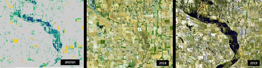
Webinar Agenda

  Part 1: Google Earth                                  Part 2: Land Cover
                                                                                 Part 3: Time Series Analysis
Engine Basics & General                              Classification & Accuracy
                                                                                    & Change Detection
      Applications                                         Assessment

    NASA’s Applied Remote Sensing Training Program                                                      3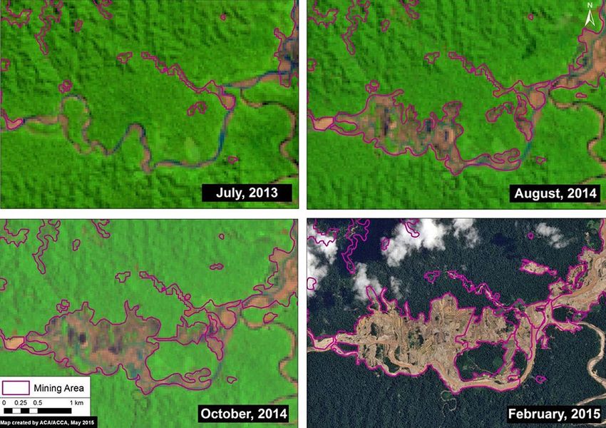
Webinar Agenda

   Part 3: Time Series Analysis
       & Change Detection
                                                    Zach Bengtsson   Juan Torres-Pérez   Amber McCullum

   NASA’s Applied Remote Sensing Training Program                                                         4
Session Outline

• Time Series Analysis and Change Detection Overview
   – Time series and change detection basics
   – Common time series and change detection methods
   – Techniques for time series analysis and change detection in GEE
• GEE Code Editor Activity
  – Landsat data retrieval and imagery preparation
  – Vegetation index time series analysis and data visualization
  – Change detection using visual inspection and image differencing
• Question & Answer Session

     NASA’s Applied Remote Sensing Training Program                    5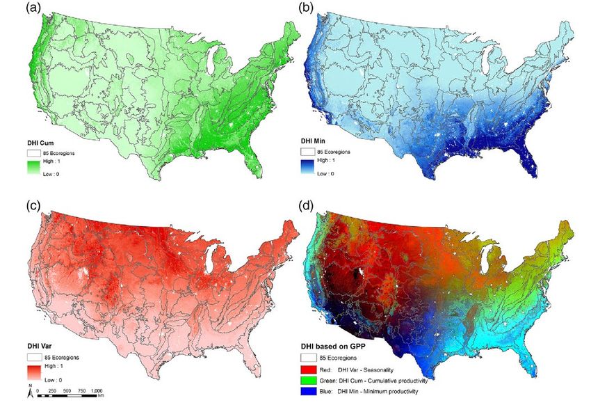
Time Series Analysis and
Change Detection Overview
Time Series Analysis with Satellite Imagery

• Using satellite imagery to monitor
  landscape change continues to improve
  with data availability and access to
  imagery processing platforms
   – Availability of long term satellite data
      sets
       • Landsat (40+ years)
       • MODIS (20+ years)
   – Increased computing power and
      cloud computing platforms (like GEE)
   – Improved processing methods

                                                       Stack of Landsat images of Australia
                                                       Image credit: Data Cube.

      NASA’s Applied Remote Sensing Training Program                                          7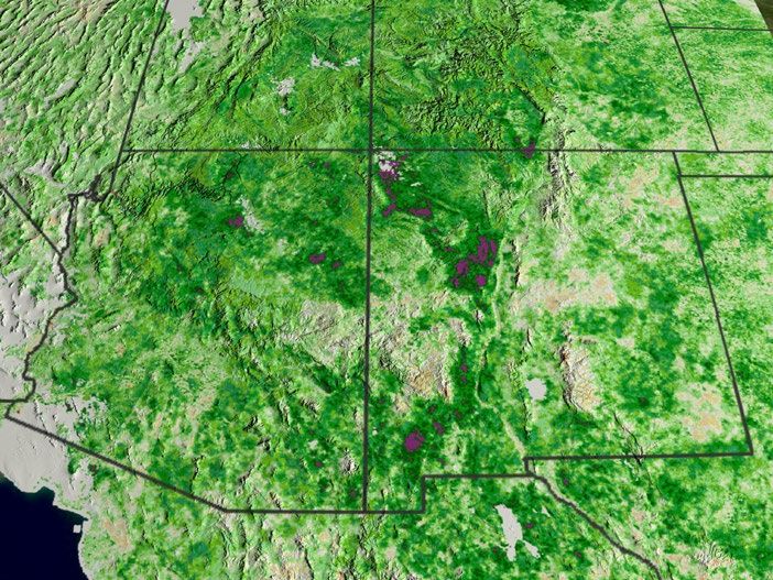
Time Series Analysis Basics
                                                         1989                                          1999
• Time series analysis looks at
   landscape change as a dynamic
   process over a number of months,
   years, and so on.
• Mapping the environment at
   various timescales can provide
   information about land
                                                         2009                                          2019
   monitoring parameters like land
   cover change trends and
   patterns in vegetation growth.
• Common uses for a time series
   approach include:
    – Identifying urban expansion
    – Mapping deforestation                             In the summer of 1988, lightning- and human-ignited fires consumed vast stretches of
    – Monitoring post-fire conditions                   Yellowstone National Park. NDVI estimates over the course of 30 years show increase in
                                                        greenness, indicating vegetation regrowth across the burn scar.
                                                        Image Credit: NASA
       NASA’s Applied Remote Sensing Training Program                                                                                      8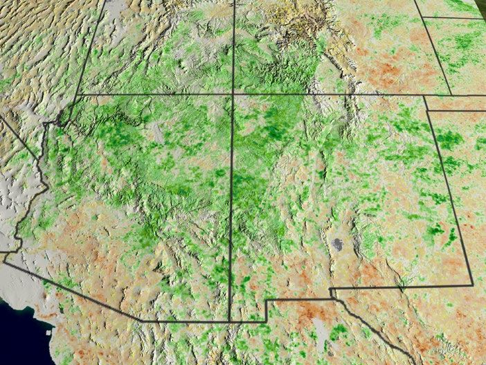
Imagery Collection Time and Dates for Time Series Analysis

• Images should be collected at about the same time of day to reduce differences
  in sun angle
• Ideally, images from different years should be within the same month or season to
  avoid seasonal and phenological differences
   – Differences in vegetation greenness
• Be aware of different annual weather conditions
   – For example, drought years vs. non-drought years

                 Aug 1999                          Aug 2000                 Aug 2001                     Aug 2002                      Aug 2003

       NDVI Anomalies in the southwestern United States. Image Credit: NASA/Goddard Space Flight Center Scientific Visualization Studio.

      NASA’s Applied Remote Sensing Training Program                                                                                        9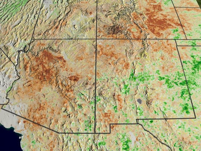
Types of Time Series Analysis
• Annual vs. seasonal trends • Anomalies
• Gradual vs. abrupt changes • Environmental Descriptors/Parameters
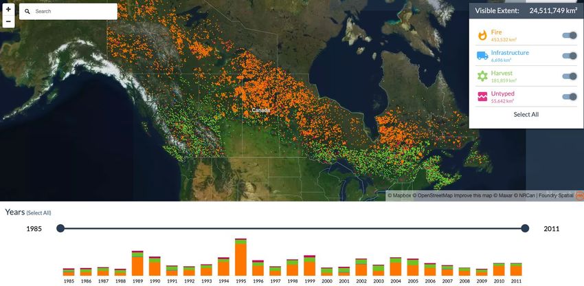
Satellite forest
monitoring in
Canada.
Image credit:
Foundry Spatial
NASA’s Applied Remote Sensing Training Program 10Annual Trends
Annual time
• Annual Trends series of LULC
maps of the
– Assessment completed Yangtze River
yearly, but for as many estuary region
from 1985 to
years as necessary 2016.
– Number of years usually Credit: Ai et al.
2020
data limited
– Useful for mapping
annual land cover/land
use changes over long
time periods
– Example: Annual time
series of land use/land
cover in the Yangtze
River estuary region
NASA’s Applied Remote Sensing Training Program 11Seasonal Trends
• Seasonal Trends
– Driven by annual Seasonal snow cover
based on MODIS
temperature and/or snow cover time series
precipitation from Mar 2000 to Feb
2008. (Winter, (top),
– Variation between Spring, Summer
seasons Autumn (bottom). The
values show the
– Can measure change percentage of time
that a pixel was snow-
within a year timeframe covered during the
– Useful in comparison of season within the time
period.
seasonal variation
between years
– Example: Snow cover
monitoring in the
Himalayas
NASA’s Applied Remote Sensing Training Program 12Gradual vs. Abrupt Changes
• Gradual changes:
– Insect infestation in forests
– Land degradation
– Forest recovery
• Abrupt changes:
– Wildfire
– Deforestation
– Urban development
• Example: Forest recovery after wildfire
in Yellowstone National Park
Changes in NDVI values between 1986 and 2006 for one site in Yellowstone
National Park
Credit: Franks, Masek, & Turner 2013
NASA’s Applied Remote Sensing Training Program 13Anomalies
• Relative difference from a long term average
• Example: FAO Global Normalized Difference Vegetation (NDVI) Anomalies
Image Credit: Food and Agriculture Organization of the United Nations
NASA’s Applied Remote Sensing Training Program 14Environmental Descriptors/Parameters
• Use time series of satellite
observations to derive
environmental descriptors/
parameters as proxies for
environmental conditions on the
ground
• Example: Dynamic Habitat
Indices (DHIs) use time series of
satellite observations of greenness
to describe vegetation dynamics
to understand bird species
richness
– Vegetation dynamics include:
productivity, minimum level of
perennial cover, degree of
vegetation seasonality
Dynamic Habitat Indices derived from MODIS GPP 2003-2014 data (a) cumulative
DHI; (b) minimum DHI; (c) variation DHI; (d) combined DHI.
Credit: Hobi, et al. 2017
NASA’s Applied Remote Sensing Training Program 15Time Series Analysis in GEE
• GEE has a variety of functions useful for time series analysis:
– Filtering and compilation of data across large datasets over time
– Analysis using map visualizations and user interface generated charts and graphs
Example chart of time series NDVI data from MODIS plotted in GEE from 2010 to 2019. Image Credit: GEE Developers
NASA’s Applied Remote Sensing Training Program 16Time Series Analysis in GEE: LandTrendr
• Landsat-based detection of
Trends in Disturbance and
Recovery
– Temporally segments a
time-series of images by
extracting the spectral
trajectories of change over
time
– Use of LandTrendr in Google
Earth Engine simplifies pre-
processing steps and can
make implementation of the
algorithm easier
– LandTrendr in GEE Guide: Comparing year of disturbance maps derived from LT-IDL and LT-GEE algorithms.
Maps show the year of detected forest disturbance, filtered to 11 pixels minimum
https://emapr.github.io/LT- mapping unit for an area of the western Cascade Mountains in Oregon.
GEE/introduction.html Image Credit: Kennedy et al. 2018
NASA’s Applied Remote Sensing Training Program 17Change Detection Basics Urban
Suburban
• The conversion of a landscape from
one dominant feature type to
another
• Examples:
– Changes in tree cover due to
wildfire or deforestation
– Urbanization
– Land degradation due to over
grazing
• Information that can be derived from
satellites:
– Where and when has change
taken place?
– How much and what kind of
change has occurred?
– What are the cycles and trends in
the change?
Mapping of urbanization in Ulaanbaatar, Mongolia from 2001 to 2014.
Image Credit: NASA EO
NASA’s Applied Remote Sensing Training Program 18Characterizing Landscape Change
• Types of Change • Broad Categories of Change
– Directional change – Change in shape or size of patches of
• Example: urban development land cover types (urbanization)
– Cyclic change – Slow changes in cover type or species
• Example: seasonal phenology composition (succession) vs. abrupt
land cover transitions (wildfire and
– Multidirectional change
deforestation)
• Example: deforestation and forest
– Slow changes in condition of a single
regeneration
cover type (forest degradation due to
insect or disease)
– Changes in timing of extent of
seasonal processes (drought
monitoring)
NASA’s Applied Remote Sensing Training Program 19Change Detection Using Remote Sensing
• Changes on the landscape can be
detected as changes in the spectral
values of pixels Exploiting Spectral Response Curves
• We can use spectral signatures to
differentiate between cover types
and calculate environmental indices
• Example pre-fire and post-fire
conditions:
– Healthy vegetation has high
reflectance in the green and
near-infrared but low in the short-
wave infrared
– Burned areas have low
reflectance in the green and
near-infrared but high in the S Healthy vegetation has a large peak in the near infrared, while soil
or burned areas are much lower. Healthy vegetation also has low
short-wave infrared reflectance in the shortwave infrared, while burned areas have high
reflectance .
NASA’s Applied Remote Sensing Training Program 20Differenced Normalized Burn Ratio
• Compare pre- and post-burn images to identify burn extent and severity
with a differenced map
dNBR = NBRprefire - NBRpostfire
(NIR – SWIR2)
NBR =
NIR + SWIR2
NASA’s Applied Remote Sensing Training Program 21Change Detection Goals
• Identification of the
geographical location and
types of changes
• Quantification of changes
• Assessment of the of the
change detection results
• Identifying the location of
and quantifying change is
easier than identifying the
cause of change.
Landsat imagery of Saudi Arabia used to map agricultural growth.
Credit: NASA
NASA’s Applied Remote Sensing Training Program 22Change Detection Considerations
• Change detection requires multi-temporal datasets
• When selecting multi-temporal remote sensing data it is important to use:
– The same sensor
– The same spatial resolution
– Data from the exact same or similar times of day, days of the year, and/or
seasons
– Data that is nearly cloud free
– Radiometrically and atmospherically corrected data
• It’s important to keep these factors in mind, because you need to minimze
changes due to data characteristics you are not interested in, so that you can
identify the changes you are interested in.
NASA’s Applied Remote Sensing Training Program 23Change Detection Considerations
• Between-class changes • Within-class changes
– Answers the question: – Based on continuous spectral or
• “Has a pixel changed and transformed spectral information
what has it changed to?” – Answers the question:
• e.g. forest to agriculture • “How much and in what
conversion direction has a pixel
changed?”
• e.g. change in vegetation
index values
NASA’s Applied Remote Sensing Training Program 24Change Detection Methods
• Visual Analysis • Image Differencing
– Simple visual analysis comparing – Use raster calculation methods to
different timesteps difference pixel values of images from
different timesteps or average
conditions
Mount Saint Helens
eruption, 1980.
Image Credit: Pantaleo,
2013,
NASA’s Applied Remote Sensing Training Program 25Change Detection: Visual Analysis
• Delineation of change through visual
comparison, digitization, and/or band
combinations
• Good for large changes like shape or
size of large patches
• Not as good for subtle changes like
land degradation
• Does not necessarily take advantage
of spectral response
Deforestation along the Upper Malinowski in Peru due to mining from Landsat
and SPOT 7.
Credit: Amazon Conservation Association
NASA’s Applied Remote Sensing Training Program 26Change Detection: Image Differencing
• Subtract image date 1 from image date 2
• 0 means no change; positive or negative
values indicate change
– OR: you can set a threshold value to
indicate change
• Image dates can be individual bands or
image transformations (NDVI, NBR, etc.)
• Advantages
– Can be used to detect subtle
changes
– Easy to compute
• Disadvantage: Can be difficult to interpret
NASA’s Applied Remote Sensing Training Program 27Image Differencing
• Image differencing takes 8 10 8 11
place across the full extent of Image Date 1
both images. 240 11 10 22
• Differences are calculated on 205 210 205 54
a pixel-by-pixel basis. 3 1 1 1
220 98 88 46
• The pixel-based nature of
143 2 2 0
image differencing allows for
more specific delineation of 107 110 0 -168
change. 5 9 7 10
• Image differencing can be 97 9 8 22
117 0 -166 -164
especially useful for examining Difference Image = Image 1
change over continuous 98 100 205 222 Image Date 2 - Image 2
indices (like those that
measure vegetation and soil). 103 98 254 210
NASA’s Applied Remote Sensing Training Program 28Image Index Calculation and Differencing
• Example Below:
– Conduct index calculation (Normalized Difference Wetness Index) on each image
– (Green-NIR)/(Green+NIR)
– Subtract one image from the other
NASA’s Applied Remote Sensing Training Program 29Previous ARSET Trainings
• Past ARSET trainings relevant to time
series and change detection:
– Investigating Time Series of
Satellite Imagery
– Change Detection for Land
Cover Mapping
– Remote Sensing for Mangroves
in Support of the UN Sustainable
Development Goals
NASA’s Applied Remote Sensing Training Program 30GEE Developer Guides
• Relevant guides to GEE features and
JavaScript Code:
– Image Collection Charts
– Time Series Animation
– LandTrendr
– Mathematical Operators
• The full list of guides and tutorials made
available by the developers:
– JavaScript and Python Guides
Image Credit: Google Earth Engine
NASA’s Applied Remote Sensing Training Program 31Time Series and Change Detection
in Google Earth Engine
https://code.earthengine.google.com/04b1c5c966b08430bbad2df4067c3175Summary
• Time series analysis relies on the compilation of satellite data over a number of
dates, weeks, months, seasons, and years to effectively monitor the progression
of landscape change.
• Change detection is only possible if time series data is available to assess either
gradual or abrupt changes to land cover types and features.
• GEE provides an “all-in-one” user experience for filtering and compiling large
datasets at various timesteps and completing necessary raster calculations
and data visualizations.
• A simple time series analysis in GEE can be completed by calculating a
vegetation index across a collection of images compiled at an annual
timestep and visualizing results in the GEE interface.
• Simple change detection in GEE can be completed through visual inspection
and image differencing techniques.
• We demonstrated these functionalities in our activity examining vegetation
change in the Amazon region from 2014-2020.
NASA’s Applied Remote Sensing Training Program 33Homework and Certificate
• One homework assignment:
– Answers must be submitted via Google Form, accessed from
the ARSET website.
– Due date for homework: July 14, 2021
• A certificate of completion will be awarded to those who:
– Attend all live webinars
– Complete the homework assignment by the deadline
– You will receive a certificate approximately two months after
the completion of the course from:
marines.martins@ssaihq.com
NASA’s Applied Remote Sensing Training Program 34Contacts
• Trainers:
– Zach Bengtsson: bengtsson@baeri.org Follow us on Twitter
– Juan Torres-Pérez: juan.l.torresperez@nasa.gov @NASAARSET
– Amber McCullum: amberjean.mccullum@nasa.gov
• Training Webpage:
– https://appliedsciences.nasa.gov/join-mission/training/english/arset-
using-google-earth-engine-land-monitoring-applications
• ARSET Website:
– https://appliedsciences.nasa.gov/what-we-do/capacity-
building/arset
NASA’s Applied Remote Sensing Training Program 35Thank You! NASA’s Applied Remote Sensing Training Program 36
You can also read