Part G Subdivision Richmond Valley Development Control Plan 2021 - Richmond Valley Council
←
→
Page content transcription
If your browser does not render page correctly, please read the page content below
Richmond Valley
Development Control Plan 2021

Part G
Subdivision

              Subdivision of land is defined within Section 4B of the EP&A
              Act.
              It generally provides that subdivision of land is the division
              of land into 2 or more parts that can be used separately or
              transferred. The term covers freehold title subdivisions as
              well as strata title and community title subdivisions.
              Exclusions from the term subdivision include opening or
              widening of public roads, consolidation of lots, etc.
              This DCP Part applies to the subdivision of land within the
              Richmond Valley Council area and offers an interpretation
              of various LEP provisions and development standards.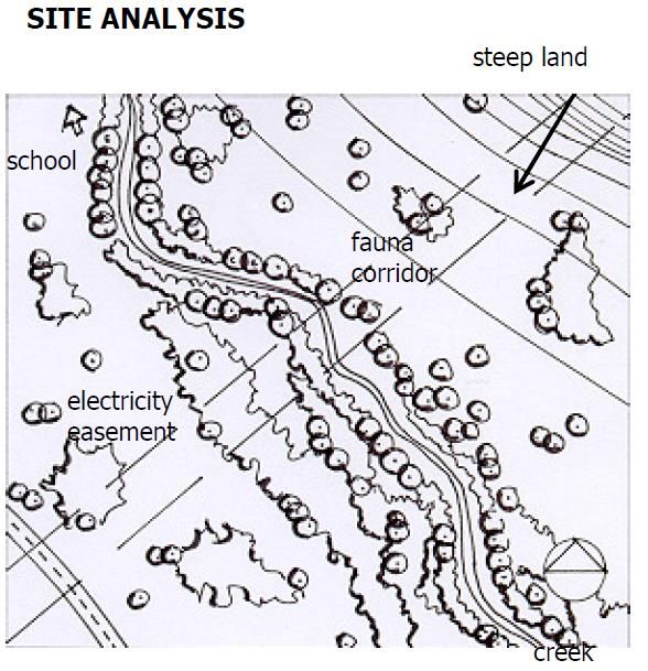
PART G - SUBDIVISION
        Part G Subdivision

G.1           General Objectives
        The general objectives of this Part are to:
        (a) provide guidelines to assist with the design and construction of subdivisions so
             that they are compatible with the natural and built environments within which
             they are sited,
        (b) provide development standards and requirements for the subdivision of land,
        (c) provide criteria for consideration during the preparation of a development
             application and its subsequent assessment, and

G.2           Subdivision Design Standards

G.2.1         Objectives
        (a) to identify design considerations for the layout of subdivisions.
        (b) to achieve the most effective and efficient use of land having regard to
            topographic, climatic, ecological, and agricultural features, along with land uses
            patterns, zoning and infrastructure/servicing.

G.2.2         Design Criteria
        (1)     Applicants are to comply with the following Design Criteria unless it can be
                demonstrated that an alternative solution to all or any of the design criteria will
                achieve an improved development outcome.
        (2)     Site Analysis
                (a) A site analysis plan is required to identify opportunities and constraints
                      relating to the subdivision pattern and potential end use of the land.
                (b) A site analysis plan should be prepared having regard to the following,
                      where relevant:
                      ▪     waterways (creeks, rivers, streams),
                      ▪     natural resources such as significant vegetation, habitat corridors,
                            key fish habitat, wetlands, and various requirements for coastal
                            protection,
                      ▪     flood prone land,
                      ▪     steep land/land slip,
                      ▪     bush fire hazard,
                      ▪     access points (vehicles, pedestrians, cyclists),
                      ▪     soil conditions (acid sulfate soils, contaminated land),
                      ▪     surrounding land uses,
                      ▪     service connections,
                      ▪     easements, zones of influence and clear zones,
                      ▪     archaeological sites,
                      ▪     topography (contours to Australian Height Datum at 1 metre
                            intervals),
                      ▪     aspect,
PART G - SUBDIVISION
Part G Subdivision
▪ drainage systems,
▪ existing buildings, driveways, septic tanks and disposal areas, and
▪ street and lot layout of locality.
(3) Subdivision and Road Design
(a) Subdivisions should be designed having regard to the environmental
constraints of the site, having regard to:
▪ Koala Habitat,
▪ Protection of native vegetation and habitats under the Biodiversity
Conservation Act,
▪ Acid Sulfate Soils,
▪ Contaminated Land,
▪ Flood Prone Land,
▪ Landform Modification,
▪ Coastal Hazards, and
▪ Bush Fire Hazard.
(b) The road hierarchy of subdivisions should also reflect road function, and
should be designed accordingly.
(c) The layout of new roads should be designed so as to:
▪ provide road links to adjoining properties,
▪ facilitate the use of public transport,
▪ achieve efficient access to all lots,
▪ encourage safe levels of vehicle speed,
▪ provide adequate sight distances (particularly at intersections),
▪ provide efficient access for service vehicles (bushfire and garbage
trucks),
▪ provide for safe and functional vehicle and pedestrian movement,
▪ adopt CPTED design principles (refer to Chapter I-10), and
▪ provide for landscaping, utility services, driveways, mailboxes, street
lighting, etc.
(d) The layout of main roads should follow a reasonably regular configuration
to make the subdivision easy to navigate, and should:
▪ provide memorable places to aid navigation,
▪ provide people with directional choice to enable traffic to run
smoothly and not confuse or overtly hinder thoroughfare,
(e) Cul-de-sacs should be avoided, but be short in length if utilised.
(f) Lots are to be designed to allow the construction of a dwelling which does
not involve more than 1 metre cut or fill, measured from natural ground
level, outside the dwellings external walls. Geotechnical reports are
required for subdividing steep land.PART G - SUBDIVISION
Part G Subdivision
(g) Subdivisions should be designed to minimise impacts on the natural
environment and retain significant landscape features.
(h) Subdivisions should incorporate regular sized lots to avoid clashes
involving housing character and amenity.
(i) It must be demonstrated that each allotment to be created, that is capable
of being used for residential or rural residential development, has at least
one suitable building site having regard to:
▪ flooding,
▪ effluent disposal,
▪ bush fire hazard,
▪ safe, practical, access between the building site and a formed public
road, and
▪ readily capable of being connected to infrastructure and services.
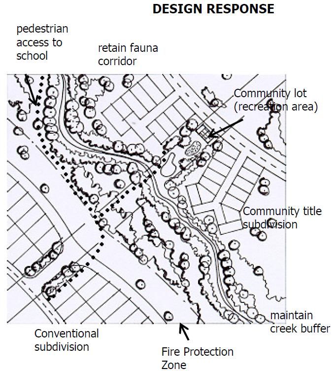
Figure G.1 Example of a subdivision design (right) having regard to the site analysis
plan (left)
(4) Energy Efficiency – Lot Orientation
(a) Subdivisions should be designed to maximise solar access.
(b) Where possible roads are to be orientated so that the majority of their
length are within the range N20oW to N30oE or E20oN to E30oS.
(c) On sloping sites, north-facing slopes improve opportunities for solar
access while south facing slopes impose a penalty on solar access.
Accordingly, smaller lots should be concentrated on northern slopes and
large lots on southern slopes.PART G - SUBDIVISION
Part G Subdivision
(5) Density (Minimum Lot Size) and dimensions
Subdivisions are not to produce lots which have areas less than that set out in
the Lot Size Map in the Richmond Valley LEP 2012.
(a) Residential Subdivisions
i. Battle Axe Lots
▪ Battle axe allotments are largely to be avoided, except in
circumstances to provide access to a small number of
allotments which would otherwise be difficult, or cost
prohibitive to access by formal road system.
▪ If a small number of battleaxe lots are utilised, they are
required to be larger in size, exclusive of the access handle (i.e.
1000 m2 where regular lots are 600-800 m2).
▪ The handle should have a minimum width of 4.5 metres in
areas requiring line-of-sight and should be constructed of
concrete at the subdivision stage.
Note. The subdivision of dual occupancies under clause 4.1C would have regard
for, but not necessarily required to adhere to the abovementioned
standards.
ii. Minimum Frontage
▪ Allotments should have a minimum frontage to a public road
of 15 metres, to be measured at the front boundary building
line.
▪ A subdivision which will involve a lot having vehicular access to
a lane will only be permitted after the lot has been
substantially developed (i.e. vacant lots off laneways are not
to be created), and the lot adjoining the lane is to have 2
metres wide frontage fenced and paved to the primary road,
to provide for pedestrian access, mailbox, services (water,
sewer, electricity, communication).
iii. Strata/Community Title
▪ Inspection of existing buildings will be required to ensure
compliance with all relevant building and fire regulations
standards.
▪ Certification of all building work, including final occupation
certificates, will be required prior to release of the
strata/subdivision certificate.
iv. Dual Occupancy
▪ Both dwellings within the development must be complete
prior to release of the subdivision certificate. As such no
vacant allotments can be created.
▪ Each allotment must comply with BCA requirements for fire
separations.
▪ See also the subdivision requirements in Part A Residential
DevelopmentPART G - SUBDIVISION
Part G Subdivision
(b) Rural Subdivisions
i. Battle Axe Lots
▪ Battle axe allotments are to be avoided.
▪ Reciprocal rights of carriageway are not supported as to avoid
conflict between neighbours over maintenance.
▪ Where justified, the access handle should be a minimum 10
metres wide, and should be no longer than 200 metres.
(c) Commercial Subdivisions
i. Battle Axe Lots
▪ Battle axe allotments are not permitted for subdivisions in
Zones B1, B2 and B3.
▪ Each allotment to be subdivided must demonstrate that the
resultant allotment is capable of being developed for
commercial development based upon its lot size, dimensions,
frontage, access and services.
(6) Services
(a) Urban Areas
i. Subdivisions in urban areas are generally required to provide
infrastructure to all lots including:
▪ road;
▪ footpath;
▪ kerb and gutter;
▪ drainage (including interallotment drainage);
▪ reticulated sewer and water;
▪ telecommunications;
▪ street lighting; and
▪ electricity.
(b) Large Lot Residential Areas
i. Subdivisions are to provide infrastructure to all lots:
a. including road and drainage, incorporating sealed driveways to
be provided to battle axe shaped lots.
ii. It must be demonstrated that each allotment can be adequately
serviced by on-site sewage effluent disposal (OSMS).
(c) Rural Areas
i. Subdivisions in rural areas may permit access by right-of-
carriageway.
ii. The right-of-carriageway is to be constructed to provide all weather
two-wheel drive vehicular access with adequate drainage provision,
however, the length of the access handle should be no longer than
200 metres, particularly when located on bush fire prone land.
iii. It must be demonstrated that each allotment can be adequately
serviced by on-site sewage effluent disposal (OSMS).PART G - SUBDIVISION
Part G Subdivision
(7) Stormwater Drainage
(a) Stormwater drainage shall be designed and provided in accordance with
Council’s specifications.
(b) The design details will need to be certified by Council before the drainage
is provided, and will need to be completed to Council’s satisfaction prior
to the issue of the Subdivision Certificate.
(c) Stormwater is to be gravity drained to Council’s drainage system. In some
circumstances inter-allotment drainage and easements over downstream
properties may be required. This will necessitate a letter of consent from
the owner(s) of the downstream properties to be submitted with the
development application.
(d) Drainage from sites should reflect the pre-existing or natural situation in
terms of location, quantity, quality and velocity.
(e) Water Sensitive Urban Design principles should be employed, particularly
with larger subdivisions.
(8) Utility Services
(a) Utility services must be extended to all lots within a subdivision in
accordance with the following table (except for common property in
community title and strata subdivisions).
Utility Service Urban Area Rural Residential Rural area
Area
Council’s water main Yes No 4 No 4
Council’s sewer main Yes No 3 No 3
Telephone Yes 1 Yes 1 No
Electricity Yes 1 Yes 1 Yes 2
1
Note. In greenfield subdivisions these services must be underground.
2
Unless the applicant can demonstrate that alternative methods of providing electricity exists or that the
provision of this service is cost prohibitive.
3
Subject to demonstrating the capability of the lots to accommodate on-site effluent disposal.
4
Each allotment would be serviced by rain water tank to be provided as part of the construction of
subsequent development.
Note. Richmond Valley LEP 2012 requires that a development application
demonstrates that the following services that are essential for the proposed
development are available or that adequate arrangements have been made to
make them available when required—
i. the supply of water,
ii. the supply of electricity,
iii. the disposal and management of sewage,
iv. stormwater drainage or on-site conservation,
v. suitable road access.PART G - SUBDIVISION
Part G Subdivision
(9) Erosion and Sediment Control
(a) Subdivisions should be designed to minimize the disturbance of lands with
topographical constraints.
(b) Conditions on the development consent will indicate whether erosion and
sediment controls will be necessary, and if so, these controls will need to
be in place before site works commence. The controls will need to be
provided in accordance with Landcom (2004) Blue Book – Managing Urban
Stormwater: Soils and Construction.
(10) Street Tree Masterplan
(a) A Street Tree Masterplan will be required for subdivisions on greenfield
sites. The Masterplan aims to guide street tree planting, providing for a
more appealing streetscape which complements its natural setting.
(b) Planting proposed by the Masterplan is to be determined having regard
to:
▪ site and dwelling boundaries,
▪ location and canopy of existing trees, noting any trees that overhang
the sit,
▪ adjacent streets and trees,
▪ any connection to open space networks or proposed public reserves,
▪ paving materials and drainage
▪ treatment,
▪ details of any existing fencing and walls, and
▪ location of underground services.
(11) Developer Contributions
(a) In many cases the payment of contributions are required to cover the cost
of services and facilities which are provided by Council. These
contributions are often levied with subdivision, prior to the issue of the
Subdivision Certificate. Contributions levied on developments may
include:
▪ section 64 contributions under the Local Government Act 1993 for
such services as water, sewer and drainage, and/or
▪ section 7.12 contributions under the Environmental Planning and
Assessment Act 1979 which consists of a levee up to 1% of the cost
of the development.
(b) Conditions on the development consent will indicate whether these
contributions are required.
(c) The value of these contributions are outlined in Council’s Revenue Policy
which is available on-line.
(12) Adoption of Northern Rivers Local Government Development Design and
Construction Manuals
(a) The Northern Rivers Local Government Development Design and
Construction Manuals are utilised for the design and construction of civilPART G - SUBDIVISION
Part G Subdivision
engineering works associated with development approvals. The Manual is
contained within 3 volumes being:
▪ Development & Design Manual,
▪ Construction Manual, and
▪ Standard Drawings.
(b) For the purposes of engineering and subdivision works reference should
be made to the standards contained within the manuals.
(c) Where doubt exists regarding standards contained within the Manuals, or
a subject has not been adequately covered, consultation should be made
with Council or any relevant Council policy for clarification or reference to
alternatively appropriate standards.You can also read