Perdaman Urea Project - Environmental Scoping Document
←
→
Page content transcription
If your browser does not render page correctly, please read the page content below

Environmental Scoping Document
                                                                Perdaman Urea Project

 Perdaman Urea Project

 Environmental Scoping Document

 Assessment No. 2184 (WA) – 2018/8383 (Commonwealth)

 Prepared for Perdaman Chemicals and
 Fertilisers Pty Ltd by Cardno
 Rev 5.0
 19 July 2019

EPA Assessment No 2184                                                              i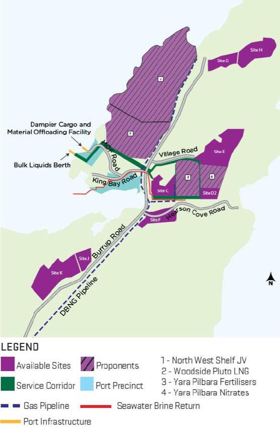
Environmental Scoping Document
                                  Perdaman Urea Project

EPA Assessment No 2184                               1
Environmental Scoping Document
                                                                                              Perdaman Urea Project

                                   Invitation to make a submission
The Environmental Protection Authority (EPA) invites people to make a submission on the draft
Environmental Scoping Document (ESD) for this proposal.
Perdaman Chemicals and Fertilisers Pty Ltd (Perdaman) (the Proponent) proposes to establish a state of the
art Urea Production Plant within the proposed Burrup Strategic Industrial Area, approximately 8 km from
Dampier and 20 km north-west of Karratha on the north-west coastline of Western Australia (WA). The draft
ESD has been prepared in accordance with the EPA’s Procedures Manual (Part IV Divisions 1 and 2). The
draft ESD outlines the work and information required as well as key areas of focus for the environmental
review. The Proponent will undertake this work and the information will be used to prepare an Environmental
Review Document (ERD).
The draft ESD is available for a public review period of 2 weeks from Wednesday 5th June 2019 closing on
Wednesday 19th June 2019.
Why write a submission?
The EPA seeks information that will inform the EPA’s consideration of the likely effect of the proposal, if
implemented, on the environment.
The EPA will use the information in the submissions to identify any additional preliminary key environmental
factors/issues and the type and extent of any additional work and information for the environmental review
that should be included in the ESD.
Submissions will be treated as public documents unless provided and received in confidence, subject to the
requirements of the Freedom of Information Act 1992.
Why not join a group?
It may be worthwhile joining a group or other groups interested in making a submission on similar issues.
Joint submissions may help to reduce the workload for an individual or group. If you form a small group (up
to 10 people) please indicate all the names of the participants. If your group is larger, please indicate how
many people your submission represents.
Developing a submission
The draft ESD specifies the form, content, timing and procedure of the environmental review and outlines the
work and/or information required to identify or predict the direct, indirect and cumulative impacts of the
proposal. The likely environmental impacts and the proposed management measures will be addressed in
the Environmental Review Document after the proponent undertakes the studies outlined in the ESD.
You may agree or disagree with, or comment on, the general issues discussed in the draft ESD or on
specific elements.
When making comments on the draft ESD:
> Suggest other preliminary key (i.e. most important) environmental factors and/or any additional work
  and/or information you consider would be appropriate.
> Clearly state your point of view and give reasons for your conclusions.
> Reference the source of your information, where applicable.
> Suggest recommendations or alternatives.
What to include in your submission
Include the following in your submission to make it easier for the EPA to consider your submission:
> Your contact details – name and address.
> Date of your submission.
> Whether you want your contact details to be confidential.
> Summary of your submission, if your submission is long.
> List points so that issues raised are clear, preferably by environmental factor.
> Refer each point to the page, section and if possible, paragraph of the draft ESD.

EPA Assessment No 2184                                                                                           2
Environmental Scoping Document
Perdaman Urea Project
> Attach any reference material, if applicable. Make sure your information is accurate and relevant.
The closing date for public submissions is 19 June 2019.
The EPA prefers submissions to be made electronically via the EPA’s Consultation Hub at
https://consultation.epa.wa.gov.au.
Alternatively submissions can be:
> posted to: Chairman, Environmental Protection Authority, Locked Bag 10, Joondalup DC, WA 6919, or
> delivered to: the Environmental Protection Authority, Prime House, 8 Davidson Terrace, Joondalup, WA
6027.
If you have any questions on how to make a submission, please contact EPA Services at the Department of
Water and Environmental Regulation on 6364 7000.
EPA Assessment No 2184 3Environmental Scoping Document
Perdaman Urea Project
Proposal Name: Perdaman Urea Project (the Project)
Proponent: Perdaman Chemicals and Fertilisers Pty Ltd
Assessment number: 2184 under Part IV EP Act
Location: Sites C & F – Burrup Strategic Industrial Area (BSIA)
Multi-user Infrastructure Corridor –BSIA
Dampier Port
Local Government Area: City of Karratha
Public review period: Environmental Scoping Document – 2 weeks
Environmental Review Document – 12 weeks
EPBC reference no: 2018/8383
1 Introduction
On 28th November 2018, the Environmental Protection Authority (EPA) determined that the above Proposal
is to be assessed under Part IV of the Environmental Protection Act 1986 (EP Act). A referral under the
Commonwealth Environment Protection and Biodiversity Conservation Act 1999 (EPBC Act) covering the
Project was submitted to the Commonwealth Department of the Environment and Energy (DoEE) online on
21st December 2018 (Referral #2018/8383).
The level of assessment under the EP Act is Public Environment Review (s. 40(2) and s. 40(4)) with
12 weeks public review.
The purpose of the Environmental Scoping Document (ESD) is to define the form, content, timing and
procedure of the environmental review, required by s. 40(3) of the EP Act. Perdaman Chemicals and
Fertilisers Pty Ltd (the Proponent) has prepared this ESD according to the procedures in the EPA’s
Procedures Manual.
Form
The EPA requires that the form of the report on the environmental review required under s. 40
(Environmental Review Document, ERD) is according to the Environmental Review Document template.
Content
The EPA requires that the Environmental Review Document (ERD) addresses matters of relevance for
environmental impact assessment pursuant to the Western Australian EP Act. Where the proposal is also a
controlled action and to be assessed under the EPBC Act through the s.87 accreditation provisions, the ERD
shall also satisfy the information requirements under both regulatory regimes, including the content outlined
in Sections 2 to 6 of this ESD.
Timing
Table 1-1 sets out the timeline for the assessment of the Proposal agreed between the EPA, the
Commonwealth DoEE and the Proponent.
EPA Assessment No 2184 4Environmental Scoping Document
Perdaman Urea Project
Assessment Timeline [Consistent with the EPA’s EIA (Part IV Division 1 and 2) Procedures Manual]
Key Assessment milestones Completion Date
EPA approves ESD 22 July 2019
EPA notifies Proponent and publishes ESD (1 week from approval) 29 July 2019
Proponent submits first draft ERD (excluding heritage survey information) 28 August 2019
EPA provides comment on first draft ERD (6 weeks from receipt of ERD) 9 October 2019
Proponent submits complete revised draft ERD with heritage survey information (end of
November 2019) 29 November 2019*
EPA authorises release of ERD for public review (2 weeks from EPA approval of ERD) 13 December 2019*
Proponent releases ERD for public review for 12 weeks 16 December 2019*
Close of public review period 9 March 2020
EPA provides Summary of Submissions (3 weeks from close of public review period) 30 March 2020*
Proponent provides Response to Submissions (1 week from receipt of submissions
summary) 6 April 2020*
EPA reviews the Response to Submissions (4 weeks from receipt of Response to
Submissions and subject to EPA meeting dates) 4 May 2020*
EPA prepares draft assessment report and completes assessment (6 weeks from EPA
accepting Response to Submissions) 15 June 2020*
EPA finalises assessment report (including two weeks consultation on draft conditions)
and gives report to Minister (6 weeks from completion of assessment) 27 July 2020*
* Note – These completion dates will need to be extended if additional revised versions of the draft ERD or Response to
Submissions document are required.
Procedure
The EPA requires the Proponent to undertake the Environmental Review according to the procedures in the
Administrative Procedures and the Procedures Manual.
Assessment under the EPBC Act, s.87 Accreditation Provisions
The Proposal has been referred to the Commonwealth DoEE (EPBC ref No 2018/8383) and determined on
28th March 2019 to be a controlled action under the EPBC Act. The Commonwealth DoEE has determined
that the Proposal can be assessed under the accredited process provisions in section 87(1)(a) of that Act.
The relevant controlling provisions for this Proposal are:
> National Heritage Places (sections 15B & 15C);
> Listed Threatened Species (sections 18 & 18A);
> Listed Migratory Species (sections 20 & 20A); and
> Commonwealth Marine Areas (sections 23 & 24A).
This ESD includes work and/or information required to be carried out and reported on in the ERD in relation
to matters of national environmental significance (MNES). The Environmental Review Document will also
address the matters in Schedule 4 of the Environmental Protection and Biodiversity Conservation
Regulations 2000.
The ERD will include a separate section relating to “Impacts on the environment of the Commonwealth
Marine Areas” for the consideration of the Commonwealth DoEE. This separate section will not form part of
EPA’s assessment of the Proposal. However, the EPA will consider potential impacts on marine turtles in
States waters under the environmental factor Marine Fauna.
EPA Assessment No 2184 5Environmental Scoping Document
Perdaman Urea Project
MNES that may be impacted by the Proposal will be identified in the ERD and the potential impacts on these
matters addressed within each relevant preliminary environmental factor identified in Table 3-11. Where risks
of relevance to MNES cannot practicably be eliminated, reduced or mitigated to avoid significant impacts,
proposed offsets to address significant residual impacts on MNES will also be discussed in the ERD.
2 The Proposal
The Proponent proposes to establish a state of the art urea production plant using natural gas as feedstock
in the Burrup Strategic Industrial Area (BSIA), approximately 8 km from Dampier and 20 km north-west of
Karratha on the north-west coastline of WA (Attachment A, Figure 1). The BSIA is a state designated area
for industrial development managed by LandCorp. The Project has been granted Project of State
Significance status under the Lead Agency Framework by the WA Government. The Project has been
granted Major Project Facilitation Status (MPFS) through the Commonwealth government’s program.
The urea plant will have a production capacity of approximately 2 million tonnes per annum (Mtpa) on Sites
C and F within the BSIA on the Burrup Peninsula (Attachment A, Figure 2 and 3). The project involves piping
natural gas from the nearby Woodside LNG plant to the project site under a long-term commercial off-take
agreement. The approvals for the connection from the Dampier to Bunbury Natural Gas pipeline (DBNGP) to
the plant’s battery limits will be the responsibility of the gas supplier (Woodside). The Project will transport
urea product along the existing East West Common User Service Corridor, via a closed conveyor, for
shipment from the nearby Dampier Port.
Native Title was determined by the Federal Court of Australia not to exist over the Burrup Peninsula (refer to
the Ngarluma-Yindjibarndi Determination - Federal Court Number WAD6017/1996). However, prior to this
determination, the State executed the Burrup Maitland Industrial Estates Agreement (BMIEA) with the
Ngarluma-Yindjibarndi, Wong-Goo-Tt-Oo, Yaburara and Mardudhunera people, which agreed the
developable industrial sites and locations that would be subject to payments by eventual proponents
developing those sites. Under the BMIEA, the Native Title parties consented to the compulsory acquisition
and extinguishment of Native Title in the BSIA in return for, among other things, the grant of freehold
interests in non-industrial land on the Burrup Peninsula to relevant approved body corporate (which in this
case is the Murujuga Aboriginal Corporation). The acquisition of Native Title over the BSIA land took place
under the future act procedure of the Native Title Act 1993 (Cth).
While the BMIEA provided for compulsory acquisition pursuant to Australian law and established an
Approved Body Corporate for the purposes of the BMIEA implementation, connection to country across the
Development Envelope for a range of Aboriginal individuals and groups pursuant to customary Aboriginal
law survives the compulsory acquisition. This continuing connection to country is relevant and must be
considered for determining relevant stakeholder interests pursuant to the EP Act and the Aboriginal Heritage
Act.
The BMIEA provided a variety of benefits to local Indigenous people through: financial compensation;
establishment of various employments; training; educational support; establishment of a Rock Art Study to
monitor the industries emissions; and the development of a Roebourne Enhancement Scheme. The
Murujuga Aboriginal Corporation 2006 (MAC) is the approved body corporate for the BMIEA. It oversees the
implementation and contractual obligations contained in the BMIEA.
The proposed location (Sites C and F) falls within the industrial areas defined by the BMIEA. Site C and the
intervening portion of land are both part of the area to which proponent payments under the BMIEA apply.
Site F is not subject to these payments as it was treated as “existing industry” under the BMIEA (having
previously been used as a laydown site).
1
In relation to controlling provision “Commonwealth Marine Areas”, on the basis of feedback from DoEE, it is noted that as Listed
Migratory Species is triggered in the controlled action decision in relation to a range of identified marine species, Commonwealth Marine
Area is also then triggered. This is because, according to the EPBC Act Policy Statement 1.1 Significant Impact Guidelines – Matters of
National Environmental Significance an action is likely to have a significant impact on the environment of the CMA if there is a real
chance or possibility that the action will have a substantial adverse effect on a population of a marine species or cetacean, including its
life cycle and distribution. A ‘population’ of a species is defined in the EPBC Act as an occurrence of a species in a particular area. In
addressing the population impacts in State waters, the Proponent will also demonstrate the level of impact applicable in Comm onwealth
marine areas as required for this trigger.
EPA Assessment No 2184 6Environmental Scoping Document
Perdaman Urea Project
The Project site is located adjacent to Murujuga National Park. Murujuga National Park is freehold land on
the Burrup Peninsula, owned by the Murujuga Aboriginal Corporation (MAC) and leased back to the State of
Western Australia. Murujuga National Park is jointly managed by representative of MAC and the Department
of Biodiversity Conservation and Attractions (DBCA).
The BSIA is the location of a number of established industrial facilities. Although not implemented,
development proposals occupying Sites C and F have also previously been subject to assessment and were
approved pursuant to Part IV of the EP Act and the EPBC Act.
The area between Sites C and F was examined by the Department of Jobs, Tourism, Science and
Innovation (JTSI) and LandCorp to establish the technical feasibility of amalgamating these two
discontiguous land parcels to a single amalgamated industrial location. Based on the Phase 1 results of this
feasibility study, the preferred site layout option is to split the urea plant footprint into two parts which are
aligned with Sites C and F. The two sites would be connected by a 30 m wide easement to accommodate an
elevated causeway for road and infrastructure requirements. The Proponent will address environmental and
heritage impacts as a result of use of Sites C and F and the connecting causeway.
The granulated urea product will be transported by closed conveyor along the existing East West Service
Corridor through to Dampier Port, where new facilities will include a stockpile and loading arm. Approvals for
the conveyor, storage and loadout facilities will be the responsibility of the Proponent. Pilbara Ports Authority
(PPA) will be responsible for the shipping berths, and any necessary associated impact assessment within
the Dampier Port.
Brine discharge will be under commercial arrangements to Water Corporation’s existing licenced facility
which has already undergone detailed environmental assessment, conditioning and ministerial approvals.
It is proposed that the existing public access road to Hearson Cove will be realigned to the existing gazetted
road reserve at the northern extent of Site F. Another realignment option to the southern extent of Site F was
also considered.
The northern realignment option would result in the public road bisecting the Project operational footprint and
necessitates substantial infilling to achieve a road surface above the 1 in 100 year flood level. It is noted that
the environmental impact of this alignment was assessed in EPA Bulletin 985 (July 2000) and approved as
part of Ministerial Statement 552 on 14 September 2000. Details of road realignment options will be
discussed further in the ERD and a preferred alignment will be described.
The regional location of the Proposal is shown in Attachment A (Figure 1 and 2), the Development Envelope
and indicative footprint of the Proposal is delineated in Attachment A (Figure 3). The Proponent will outline
alternatives considered in the ERD, including process design options, site selection and layout alternatives.
The key characteristics of the Proposal are set out in Tables 2-1 and 2-2. The key Proposal characteristics
may change due to the findings of studies and investigations conducted and the application of the risk
management hierarchy by the Proponent. The potential impacts of any such changes will be assessed in the
Environmental Risk Assessment (ERA) as outlined in Section 4.
Summary of the proposal
Item Detail
Proposal title Perdaman Urea Project
Proponent name Perdaman Chemicals and Fertilisers Pty Ltd
Short description The Proponent intends to construct and operate a urea plant with a production
capacity of approximately 2 million tonnes per annum (Mtpa) on Sites C and F
within the Burrup Strategic Industrial Area (BSIA) on the Burrup Peninsula.
Natural gas for the urea plant will be sourced from a nearby domestic gas
plant. The urea product will be transported via closed conveyor to the nearby
Dampier Port for export via Panamax vessels.
EPA Assessment No 2184 7Environmental Scoping Document
Perdaman Urea Project
Location and proposed extent of physical and operational elements
Element Location Proposed extent
Physical elements
Site C& F Figures Site C: Approximately 34 ha
2&3
Site F: Approximately 38 ha
Causeway: Approximately 1.5 ha
Gas Supply Pipeline Figure 3 Clearing of 1 ha to link to existing gas pipeline easements.
Ammonia Plant Figure 3 3,500 tpd nominal capacity - no 3rd party sales
Urea Production Plant Figure 3 Footprint approximately 73.5 ha.
6,200 tpd nominal capacity, granulated product Nominal 2.05 Mtpa
Infrastructure and Logistics Figure 3 including:
Buildings Administration buildings;
Operation control room;
Maintenance workshop;
Parts and materials warehousing; and
Plant security.
Utility Block Figure 3 Air separation (~2,200 tpd);
Power generation (~ 100 MW)
Water treatment;
Cooling water;
Flare;
Firefighting facilities; and
Other utilities.
Laydown associated with Figure 3 Clearing/fill of approximately 50 ha.
Construction
Product Conveyor to Port Figure 3 Closed conveyor along the existing East West Service Corridor
(10ha) which is already disturbed.
Clearing of 1ha to connect from site boundary to the East West
Service Corridor (3 options under consideration).
Product Storage Areas Figure 3 Ammonia: Storage of a maximum of 10,000 tonnes capacity on
plant site in refrigerated tank
Urea (plant site): minimum 75,000 tonnes capacity, fully enclosed
shed
Urea (port site): 75,000 tonnes capacity, fully enclosed shed
Operational elements
Gas Supply (Natural Gas) Figure 3 130 terajoules per day supplied via a gas pipeline
Urea Formaldehyde Input Figure 3 11 ktpa approximately
Power Supply Figure 3 Internal generation
Water Supply Figure 3 25.2 Glpa from existing sea water supply by Water Corporation.
Stormwater Figure 3 Stormwater to be treated on site prior to discharge.
Wastewater Figure 1 Input to existing licenced WaterCorp Brine discharge pipeline
Saline Water Discharge Figure 1 12-13 Glpa approximately (subject to feed water salt content) to
be disposed as input to existing licenced saline pipeline to sea,
subject to commercial agreement with Water Corporation
Solid Waste Some solid waste from site water treatment residue to appropriate
disposal site
Spent catalyst/resins to appropriate disposal sites
EPA Assessment No 2184 8Environmental Scoping Document
Perdaman Urea Project
Element Location Proposed extent
Construction waste streams to be recycled where such services
are available from waste management contractors. Residual
wastes to local landfill in accordance with landfill classification
Energy Efficiency Approximately 21 GJ/t urea (LHV)
Approximately 5.1 Gcal/t urea (LHV)
Material Transport Figure Transport of urea (granules) through conveyor to Dampier Port
1&3 along existing service corridor
Urea Shiploading System Figure 3 Travelling (closed) conveyor-fed, cantilever arm loader with direct
discharge to ship hold via chute.
Nominal loading capacity of 2,200 tonnes per hour.
Shipping Figure 3 Urea 50-100 times per year, depending on destination port limits
on vessel capacity
Noise < 35 dB(A) at nearest noise sensitive premises
< 65 dB(A) at plant boundary
Air Emissions
Oxides of Nitrogen (NOx) (as NO2) 319 tpa approximately from power generation and fired heater
Carbon Dioxide (CO2) 0.7 Mtpa approximately.
Includes 0.07 Mtpa of CO2 supplied in natural gas.
Sulphur Dioxide (SO2) 5 tpa approximately
Methane (CH4) Traces, < 1 tpa
Ammonia (NH3) 400 tpa maximum, to be minimised as practicable during detailed
engineering design
Urea Particulates 353 tpa maximum, to be minimised as practicable during detailed
engineering design.
Methanol < 1tpa
Dust Construction and fugitive operational emissions
The Project timeline is outlined in Table 2-3.
Project Timeline
Timeline Description
October 2018 – July 2020 Environmental assessment, Basic engineering, Financial Closure
July 2020 – Q4 2020 Detailed engineering, Procurement, Construction starts
Q4 2020 – Q4 2023 Construction, Mechanical completion
Q1 2024 Commissioning of the Plant, Start-up
Q2 2024 Full production
2049 (estimated) Decommissioning
EPA Assessment No 2184 9Environmental Scoping Document
Perdaman Urea Project
3 Preliminary key environmental factors and scope of work
The preliminary key environmental factors for the environmental review are:
1. Coastal Processes
2. Marine Environmental Quality
3. Marine Fauna
4. Flora and Vegetation
5. Terrestrial Fauna
6. Inland Waters
7. Air Quality
8. Social Surroundings
Table 3-1 outlines the work required for each preliminary key environmental factor and contains the following
elements for each factor:
> EPA factor and EPA objective for that factor.
> Relevant activities – the proposal activities that may have a significant impact on that factor.
> Potential impacts and risks to that factor.
> Required work for that factor.
> Relevant policy and guidance – EPA (and other) guidance and policy relevant to the assessment.
Other environmental factors or matters are addressed in Section 4.
EPA Assessment No 2184 10Environmental Scoping Document
Perdaman Urea Project
Preliminary key environmental factors and required work
1. Coastal Processes
EPA objective To maintain the geomorphic processes that shape coastal morphology so that the environmental values of the coast are protected.
Relevant activities Construction activities associated with the use of a causeway interconnecting Site C and Site F and then operation of project related
infrastructure that connects the two sites.
Potential impacts and risks The site layout and design has been revised since the Third party referral in May 2018, to optimise the location of the process plant
infrastructure within Sites C and F, and to construct a causeway between the two areas.
The proposed causeway interconnecting Sites C and F has the potential to impact on coastal processes, particularly tidal movements.
This could affect groundwater salinity and hydrodynamics which in turn could result in impacts to intertidal and supratidal vegetation.
The Project will comply with State and national guidelines as well as Pilbara Ports Authority regulations and Environmental
Management Plan.
Required work 1.1. Review the potential impacts associated with the Proposal on coastal processes.
1.2. Describe water movements and the period and frequency that the area either side of the causeway is flooded, pre- and post-
construction, including under cyclonic conditions.
1.3. Describe the potential consequences of any changes to sediment erosion and deposition and to adjacent benthic communities
and habitats.
1.4. Demonstrate how the Proposal has been located and designed to avoid, minimise and mitigate impacts to coastal processes.
1.5. Demonstrate and document how the EPA’s objective for this factor can be met.
1.6. To the extent that residual impacts cannot be avoided, reduced, mitigated or subsequently restored, describe the implementation
of appropriate offsets.
Relevant policy and guidance EPA Policy and guidance
- EPA (2018) Statement of Environmental Principles, Factors and Objectives
- EPA (2016) Environmental Factor Guideline: Coastal Processes
Other policy and guidance
- ANZEC and ARMCANZ (2000) Australian and New Zealand Guidelines for Fresh and Marine Water Quality
2. Marine Environmental Quality
EPA objective To maintain the quality of water, sediment and biota so that environmental values are protected.
Relevant activities The discharge of wastewater from the urea project into King Bay via the Water Corporation’s Multi-User Brine Return Line (MUBRL)
could change current operational parameters of that approved facility.
Potential impacts and risks Localised changes to water quality associated with the brine discharge through the Water Corp brine disposal line.
EPA assessment Reports 1014 and 1044 assessed the environmental aspects of the operation of the MUBRL.
Ministerial Statement 594 provides all necessary approvals to allow the Project to input to the MUBRL.
EPA Assessment No 2184 11Environmental Scoping Document
Perdaman Urea Project
EPA assessment Reports 1014 and 1044 and Ministerial Statement 594 both provide approval for “Potentially, other desalination
plants at other developers’ sites”. The assessment concluded that “the factor of marine flora and fauna can be managed to meet the
EPA’s objective to maintain the ecological function, abundance, species diversity and geographic distribution of marine flora
(seagrass and macro-algae) and marine fauna. Modelling indicates that the EQC guidelines will be met apart from within a 40m
mixing zone at the outfall. The predicted increase in seawater temperature near the outfall is considered to be acceptable. Impacts
will be limited to local infauna, while nearby coral reef systems are not predicted to be affected…”
The Project’s wastewater will not be discharged directly to the environment.
The Project’s wastewater will be discharged under commercial arrangement into the approved MURBL.
The Project’s wastewater discharge into the MURBL will not impact the ability of the MURBL to meet approved specification and
therefore the potential risk is unlikely to arise.
Air emissions from the Proposal have the potential to impact on marine water quality.
Required work 2.1. Confirm that the Project wastewater discharge quantity can be accommodated by the WaterCorp approved MUBRL.
2.2. Demonstrate how all reasonable and practicable steps have been taken to prevent or minimise the wastewater discharge and
associated contaminants from the Proposal.
2.3. Describe the volume, composition and frequency of waste water discharge from the urea plant to the MUBRL.
2.4. Demonstrate that the residual contaminants in the predicted wastewater discharge from the Proposal, in combination with other
future industrial discharges to the MUBRL, will not compromise the ability of the Water Corporation to meet the requirements of
Ministerial Statement 594 and the ANZECC and ARMCANZ (2000) species protection level water quality guidelines within the
0.01 km2 mixing zone as recommended in the EPA Report 1044.
2.5. Prepare a monitoring and management plan prior to construction that establishes acceptable water quality targets for the urea
plant discharge to the MUBRL and the monitoring locations, frequency, measurement protocols, assessment protocols,
management commitments and reporting arrangements for demonstrating the water quality targets are met.
2.6. Assess the potential impact on marine water quality from the Proposal’s air emissions and demonstrate the application of the
mitigation hierarchy.
Relevant policy and guidance EPA Policy and guidance
- EPA (2018) Statement of Environmental Principles, Factors and Objectives
- EPA (2016) Environmental Factor Guideline: Marine Environmental Quality
- EPA (2016) Technical Guidance: Protecting the Quality of Western Australia’s Marine Environment
Other policy and guidance
- ANZEC and ARMCANZ (2000) Australian and New Zealand Guidelines for Fresh and Marine Water Quality
- Australian New Zealand Food Standards Code
- DOE (2006) Pilbara Coastal Water Quality Consultation Outcomes – Environmental Values and Environmental Quality
Objectives, Marine Series Report No 1
- Western Australian Shellfish Quality Assurance Program
- National Water Quality Management Strategy
EPA Assessment No 2184 12Environmental Scoping Document
Perdaman Urea Project
3. Marine Fauna
EPA objective To protect marine fauna so that biological diversity and ecological integrity are maintained.
In the context of this objective: Ecological integrity is the composition, structure, function and processes of ecosystems, and the natural
range of variation of these elements.
Relevant activities Construction of the port-side infrastructure and product shipment, light spill from project facilities.
Construction activities associated with the use of a causeway interconnecting Site C and Site F and operation of the project related
infrastructure that connects the two sites.
Potential impacts and risks Accidental discharges.
Underwater noise during construction can negatively impact marine fauna.
Inappropriate lighting can alter natural turtle behavior during the nesting season.
Introduction of marine pests associated with vessel movements.
The Project will comply with State and national guidelines as well as Pilbara Ports Authority regulations and procedures with regards to
vessels movements, loading-unloading and biosecurity procedures.
The proposed urea plant processing facility is located in proximity to Burrup Road and the mangroves and supratidal to intertidal flat
area near the eastern side of King Bay.
With regard to the potential for turtle activity at the Port Facility, the site has been determined, based on a desktop assessment, to not
be suitable habitat for nesting marine turtles.
Required work 3.1. Describe the marine fauna likely to be impacted by the Proposal, including identification of critical habitat and ecological windows
for affected species (including, but not limited to, the Loggerhead Turtle – Caretta caretta, the Green Turtle - Chelonia mydas, the
Leatherback Turtle – Dermochelys coriacea, Hawksbill Turtle – Eretmochelys imbricate and the Flatback Turtle – Natator
depressus).
3.2. Assess the values and significance of marine fauna likely to be impacted by the Proposal.
3.3. Quantify the likely direct and indirect impacts to marine fauna in terms of the extent, duration and severity.
3.4. Outline the proposed mitigation measures and monitoring strategies to avoid and/or minimise impacts on marine fauna.
3.5. To the extent that residual impacts cannot be avoided, reduced, mitigated or subsequently restored, describe the implementation
of appropriate offsets.
Relevant policy and guidance EPA Policy and guidance
- EPA (2018) Statement of Environmental Principles, Factors and Objectives
- EPA (2016) Environmental Factor Guideline: Marine Fauna
- EPA (2016) Technical Guidance: Protecting the Quality of Western Australia’s Marine Environment
Other policy and guidance
- Department of the Environment and Energy (DoEE) (2018) Threat abatement plan for the impacts of marine debris on the
vertebrate wildlife of Australia’s coasts and oceans
EPA Assessment No 2184 13Environmental Scoping Document
Perdaman Urea Project
- DoEE (2017) Threat abatement plan for predation, habitat degradation, competition and disease transmission by feral pigs
(Sus scrofa)
- DoEE (2017) Habitat critical to the survival of marine turtles in Australian Waters
- DoEE (2017) Recovery plan for marine turtles in Australia 2017-2027
- Department of the Environment, Water, Heritage and the Arts (DEWHA) (2013) Significant Impact Guidelines 1.1 – Matters of
National Environmental Significance
- DEWHA (2008) Threat abatement plan for predation by the European red fox.
- DEWHA (2008) Approved Conservation Advice for Dermochelys coriacea (Leatherback Turtle)
- Department of Sustainability, Environment, Water, Population and Communities (DSEWPaC) (2012) Marine bioregional plan
for the North-west Marine Region. Prepared under the EPBC Act 1999
- DSEWPaC (2012) EPBC Act Environmental Offsets Policy
- Government of Western Australia (2014) Environmental Offsets Guidelines
- Government of Western Australia (2011) Environmental Offsets Policy
- Pilbara Ports Authority (7 March 2018) Vessel Introduced Marine Pest Risk Assessment Procedure, Port of Port Hedland
- Pilbara Ports Authority Environmental Management Plan (2018-2019)
- Threatened Species Scientific Committee (TSSC) (2009) Commonwealth Listing Advice on Dermochelys coriacea. DEWHA.
4. Flora and Vegetation
EPA objective To protect flora and vegetation so that biological diversity and ecological integrity are maintained.
Relevant activities Flora and vegetation will need to be cleared to facilitate the construction of the urea plant and associated infrastructure.
Potential impacts and risks Fragmentation of populations, isolation of populations/occurrences.
Impacts on habitat that supports the flora and vegetation.
Impacts on other species with important ecological functions, e.g. pollinators, seed dispersal vectors, essential symbiotic fungi.
Changes in air quality including dust deposition.
Introduction or promotion of weeds and/or disease, and temporary impacts such as fire.
Altered hydrology, including alteration of surface water flow.
A flora and vegetation survey has been undertaken at the site. The results of this and any future follow-up surveys, if required, will be
presented and discussed in the ERD and considered in the context of previous records and survey reports relevant to the area. Where
surveys were undertaken prior to scoping, justification will be provided to demonstrate that they are relevant and consistent with current
EPA Guidance.
Required work 4.1. Characterise the flora and vegetation within the proposed project area including its significance within a wider regional context.
4.2. Identify and characterise the flora and vegetation of areas that may directly or indirectly be impacted by the proposal in
accordance with Technical Guidance - Flora and Vegetation Surveys for Environmental Impact Assessment, December 2016.
This should include sampling more broadly to inform local and regional context.
EPA Assessment No 2184 14Environmental Scoping Document
Perdaman Urea Project
4.3. Review and revise as appropriate, matters in relation to the northern option for realignment of Hearson Cove Road to further
inform and update the previous considerations pursuant to EPA Bulletin 985 and Ministerial Statement 552 on relevant
environmental impacts.
4.4. Provide an analysis of the vegetation and significant flora species present and likely to be present within the proposed
development envelope, including any potential indirect impact areas outside of the project footprint. Include a quantitative
assessment of levels of impact on significant flora, priority ecological communities and all vegetation units. Index of Biodiversity
Surveys for Assessments (IBSA) data package will be provided with the draft ERD.
a. For significant flora, this includes:
i. Establish a regional baseline context
ii. Number of individuals and population records in the context of the Murujuga national park and other surveyed
sites
iii. Numbers and proportions of individuals and populations directly or potentially indirectly impacted, and
iv. Number / proportions / populations currently protected within the conservation estate (where known)
b. For significant ecological communities and all vegetation units this includes:
i. The area of representation in the project area (in hectares) and relative to representation in the Murujuga national
park directly or potentially indirectly impacted, and
ii. Proportion / hectares of the species, community or vegetation unit currently protected within conservation estate
4.5. Demonstrate application of the mitigation hierarchy and that all reasonable and practicable measures have been taken to reduce
the proposed project footprint based on progress in the Proposal design and understanding the environmental impacts.
4.6. Outline the proposed mitigation measures and monitoring strategies to avoid and/or minimise impacts on flora and vegetation.
4.7. To the extent that residual impacts cannot be avoided, reduced, mitigated or subsequently restored, describe the implementation
of appropriate offsets.
Relevant policy and guidance EPA Policy and guidance
- EPA (2018) Statement of Environmental Principles, Factors and Objectives
- EPA (2016) Environmental Factor Guideline: Flora and Vegetation
- EPA (2016) Technical Guidance: Flora and Vegetation Surveys for Environmental Impact Assessment
Other policy and guidance
- Department of Sustainability, Environment, Water, Population and Communities (DSEWPaC, 2012) EPBC Act Environmental
Offsets Policy
5. Terrestrial Fauna
EPA objective To protect terrestrial fauna so that biological diversity and ecological integrity are maintained.
In the context of this objective: Ecological integrity is the composition, structure, function and processes of ecosystems, and the natural
range of variation of these elements.
EPA Assessment No 2184 15Environmental Scoping Document
Perdaman Urea Project
Relevant activities Clearing of flora and vegetation, physical disturbance to facilitate the construction of the urea plant and associated infrastructure and
noise during construction.
Operation of the urea plant, vehicle movements.
Potential impacts and risks Terrestrial fauna habitat loss, degradation or fragmentation as a result of the Project.
Reduction of the diversity and abundance of species in the area.
The introduction or promotion of weeds, introduced feral fauna or pests and disease.
Reduced or prevention of access to feeding or roosting habitats.
Disruption of the dispersal of individuals required to colonise new areas inhibiting maintenance of genetic diversity between
populations.
Disruption of pollinators and seed dispersal vectors.
Noise and anthropogenic impact on threatened terrestrial fauna species including the Red Knot, the Ghost Bat, the Pilbara Olive
Python and the Northern Quoll.
A Level 1 terrestrial fauna survey has been undertaken at the site. The results of this and any further relevant surveys, if required, will
be presented and discussed in the ERD. The Burrup has been well studied and the baseline ecology is well known, therefore risks are
calculable.
Required work 5.1. Characterise the terrestrial fauna within the proposed project area including its significance within a wider regional context.
5.2. Undertake fauna surveys, as required and in accordance with the EPA Technical Guidance, in areas that are likely to be directly
or indirectly impacted as a result of the Proposal. Where surveys were undertaken prior to scoping, justification will be provided
to demonstrate that they are relevant and consistent with current EPA Guidance.
5.3. Describe the impacts and risks associated with the proposal on the identified species including, but not limited to, the Olive
Python (Pilbara subspecies) (Liasis olivaceus barroni), the Northern Quoll (Dasyurus hallucatus) and the Ghost Bat
(Macroderma gigas).
5.4. Identify the potential impacts to the Priority 1 Priority Ecological Community (PEC) – Burrup Peninsula Rock Pool Communities,
including Short-Range Endemics (SREs).
5.5. Identify likelihood of EPBC Act conservation significant species to occur within/near the proposed project area, including:
a. Information on the abundance, distribution, ecology, and habitat preference of the listed species.
b. Information on the conservation value of each habitat type from a local and regional perspective, including the
percentage representation of each habitat type on site in relation to its local and regional extent.
c. If a population of a listed species is present on the site, its size and the importance of that population from a local and
regional perspective.
d. An assessment of the risk of impact to any listed threatened species as a result of project activities.
e. IBSA data package will be provided with the draft ERD.
5.6. Analyse the extent of clearing, including the type of habitat to be cleared or impacted, and determine the significance of impact
in relation to terrestrial fauna, including the listed threatened species and listed migratory species.
EPA Assessment No 2184 16Environmental Scoping Document
Perdaman Urea Project
5.7. Review and revise as appropriate, matters in relation to the northern option for realignment of Hearson Cove Road to further
inform and update the previous considerations pursuant to EPA Bulletin 985 and Ministerial Statement 552 on relevant
environmental impacts.
5.8. Demonstrate application of the mitigation hierarchy to avoid and minimise impacts to terrestrial fauna.
5.9. Describe the proposed mitigation measures and monitoring strategies to avoid and/or minimise impacts on terrestrial fauna.
5.10. To the extent that residual impacts cannot be managed to ALARP, describe the implementation of appropriate offsets.
5.11. Demonstrate and document how the EPA’s objective for this factor can be met.
Relevant policy and guidance EPA Policy and guidance
- EPA (2018) Statement of Environmental Principles, Factors and Objectives
- EPA (2016) Environmental Factor Guideline: Terrestrial Fauna
- EPA (2016) Technical Guidance: Terrestrial Fauna Survey
- EPA (2016) Technical Guidance: Sampling Methods for Terrestrial Vertebrate Fauna
- EPA (2016) Technical guidance: Sampling of short range endemic invertebrate fauna
Other policy and guidance
- Commonwealth of Australia (1996) The National Strategy for the Conservation of Australia’s Biological Diversity
- Commonwealth of Australia (2001) National Objectives and Targets for Biodiversity Conservation 2001-2005
- Department of the Environment (DoE) (2015) Wildlife Conservation Plan for Migratory Shorebirds
- DoE (2015) Threat abatement plan for predation by feral cats
- DoEE (2017) Industry guidelines for avoiding, assessing and mitigating impacts on EPBC Act listed migratory shorebird
species
- Department of the Environment, Water, Heritage and the Arts (DEWHA) (2011) Survey Guidelines for Australia’s Threatened
Reptiles
- DEWHA (2010) Survey Guidelines for Australia’s Threatened Bats
- DEWHA (2010) Survey Guidelines for Australia’s Threatened Birds
- DEWHA (2009) Significant impact guidelines for 36 migratory shorebirds species (EPBC Act Policy Statement 3.21
- DEWHA (2008) Threat abatement plan for predation by the European red fox.
- DEWHA (2008) Approved Conservation Advice for Liasis olivaceus barroni (Olive Python – Pilbara subspecies)
- Department of Sustainability, Environment, Water, Population and Communities (2011) Threat abatement plan to reduce the
impacts on northern Australia’s biodiversity by the five listed grasses
- Government of Western Australia (2014) Environmental Offsets Guidelines
- Government of Western Australia (2011) Environmental Offsets Policy
- Hill, B.M. & S.J. Ward (2010) National Recovery Plan For the Northern Quoll Dasyurus hallucatus
- Threatened Species Scientific Committee (2016) Conservation Advice Calidris canutus Red knot.
- Threatened Species Scientific Committee (2005) Commonwealth Listing Advice on Northern Quoll (Dasyurus hallucatus)
EPA Assessment No 2184 17Environmental Scoping Document
Perdaman Urea Project
6. Inland Waters
EPA objective To maintain the hydrological regimes and quality of groundwater and surface water so that environmental values are protected.
Relevant activities The proposed plant and infrastructure layout and associate construction and operational activities have the potential to impact on the
hydrological regimes and quality of surface water and groundwater.
Potential impacts and risks Potential groundwater and surface water impacts during construction and operation of the plant
Changes of surface water flows
At this stage based on an initial risk assessment on the current design concept, the plant site layout has been optimised to mitigate the
risk of obstruction of surface water flows.
The site layout and design has been revised since the Third party referral in June 2018 to optimise the location of the process plant
infrastructure within Sites C and F, and to construct a causeway between the two areas. The footprint of this proposed layout will not
significantly impede surface water flow associated with tides and surface run off from surrounding areas.
The potential for realignment of the Hearson Cove Road into the existing gazetted road reserve at the northern edge of Site F would
require infill to ensure the road was at a level above the 1 in 100 year flood level. This could result in potential groundwater and surface
water impacts.
Required work 6.1. Identify and describe the environmental values and significance of the hydrological regime within the development envelope.
6.2. Assess the potential impacts from construction and operation of the Proposal on the dependent environmental values identified.
6.3. Review and revise as appropriate matters in relation to the northern option for realignment of Hearson Cove Road to further
inform and update the previous considerations pursuant to EPA Bulletin 985 and Ministerial Statement 552 on relevant
environmental impacts.
6.4. Demonstrate application of the mitigation hierarchy and that all reasonable and practicable measures have been taken to ensure
hydrological regime and groundwater and surface water quality are maintained.
6.5. Develop an environmental monitoring program to outline the proposed monitoring regime to ensure the objectives for surface
water and groundwater quality are being achieved and to include contingency measures in the event that they are not met.
6.6. Demonstrate and document how the EPA’s objective for this factor can be met.
Relevant policy and guidance EPA Policy and guidance
- EPA (2018) Statement of Environmental Principles, Factors and Objectives
- EPA (2016) Environmental Factor Guideline: Inland Waters
7. Air Quality
EPA objective To maintain air quality and minimise emissions so that environmental values are protected.
Relevant activities Operation of the urea plant and dust/particulate emissions from construction activities.
Potential impacts and risks Air emissions from the proposed urea plant have the potential to impact on sensitive receptors including nearby rock art and
contribute to a cumulative industrial emissions load that could increase the potential for significant impact to the values of the
National Heritage Listed (NHL) place.
EPA Assessment No 2184 18Environmental Scoping Document
Perdaman Urea Project
Air emissions from the proposed urea plant have the potential to contribute to climate change.
Air emissions from the proposed urea plant have the potential to stimulate vegetation growth, which could potentially increase the
risk of fires.
Required work 7.1. Characterise existing (baseline) air quality and local and regional meteorology within the Murujuga airshed, drawing on the
findings of relevant studies and publicly available monitoring datasets. This would be undertaken either separately by the
Proponent, or collaboratively with other industry data custodians.
7.2. Identify the key air pollutants of potential concern and characterise the emissions from the Project and other existing and
proposed future industrial emission sources and both existing and proposed future shipping activities within the Murujuga
airshed, within the context of the current air emissions inventory for the region.
7.3. Identify the key sensitive receptors in terms of potential health and amenity impacts and heritage values within the Murujuga
airshed.
7.4. Evaluate the potential incremental impact of air emissions from the Project on key receptors in the vicinity of the project area.
a. Undertake air dispersion modelling. The objective of this modelling is to predict the potential ambient air quality impacts of
the Project. This will include scenarios considering the emissions from the Project (in isolation), the increased emissions
that would be generated during start-up, upset conditions, and shutdown; and the incremental cumulative impact of the
Project considering other industry currently operating (or approved to operate but yet to be built) and proposed future
industrial facilities such as Wesfarmers Downstream Chemical Production Facility2 in the project area. Emissions from
existing and proposed future shipping activities will also be included in the cumulative air quality modelling scenarios3.
Contour plots and tables listing the modelled ambient ground level concentrations for the air pollutants of concern for the
relevant modelling scenarios will be included.
b. Evaluate the potential incremental human health and amenity impact of the Project by assessing predicted pollutant
concentrations in the ambient air at key receptors against relevant ambient air quality standards.
c. Evaluate the potential incremental risk of impact upon rock art by assessing predicted pollutant deposition rates at key
sensitive receptors. This assessment will be done within the context of the Murujuga Rock Art Strategy (released on 15
February 2019), which provides a monitoring, analysis and decision-making framework to protect Aboriginal rock art
located on the Dampier Archipelago and Burrup Peninsula listed National Heritage Place.
7.5. Identify and justify all reasonable and practicable emission reduction equipment and proposed technologies, and demonstrate
the use of industry best practice pollution control technology and plant processes including benchmarking against world’s best
practice for urea production plants.
2
In relation to proposed future industrial facilities it is noted that as these facilities are only proposals and not yet approved, relevant prim ary emissions data may not be accessible in the public domain.
While best endeavours will be used to access relevant primary data, where this cannot be sourced the modelling will include generic surrogate information for a comparable plant and sited in the
proposed development location.
3
In relation to emissions from shipping it is noted that primary data recording emissions from actual individual or aggregate shipping movements in the Port of Dampier is not available. Therefore an
appropriate surrogate dataset as agreed with the Air Quality Branch and WA EPA will be incorporated in the model to account f or this source of emissions into the Murujuga airshed.
EPA Assessment No 2184 19Environmental Scoping Document
Perdaman Urea Project
7.6. Characterise greenhouse gas emissions (type and quantities) from the Project and estimate the expected direct and indirect
greenhouse gas emissions in accordance with the National Greenhouse and Energy Reporting Act 2007 (NGER Act), and
assess the contribution to regional, state, national, and international greenhouse gas emissions.
7.7. Analyse greenhouse gas intensity (i.e. quantity of carbon dioxide equivalent - CO2-e generated per tonne of product produced)
and compare with published current benchmarked world’s best practice for urea production plants, equipment and operations.
Develop a Greenhouse Gas Management Plan and detail the management and mitigation measures that will be used to reduce
greenhouse gas emissions and improve operational efficiency using the mitigation hierarchy, including the management and
mitigation measures that can be implemented over time to achieve a long-term reduction in greenhouse gas emissions. Identify
and justify the contemporary best practice management and mitigation measures that will be implemented.
7.8. Include information on the development of an Air Quality Management Plan and the objectives, management and mitigation
measures, trigger and contingency actions, and monitoring of air emissions and ambient air quality, that will be employed to
ensure that residual impacts are not greater than predicted. Potential credible opportunities to achieve a long-term reduction in
air emissions of concern using best practice measures will be identified and evaluated in the ERD.
7.9. Demonstrate and document how the EPA’s objective for this factor can be met.
7.10. Predict the extent, severity, and duration of any residual impacts associated with the air pollutant and greenhouse gas emissions
from the Project that may be expected after implementing the proposed management and mitigation measures.
Relevant policy and guidance EPA Policy and guidance
- EPA (2018) Statement of Environmental Principles, Factors and Objectives
- EPA (2016) Environmental Factor Guideline: Air Quality
- NSW EPA (2016) Approved Methods for the Modelling and Assessment of Air Pollutants in New South Wales
Other policy and guidance
- Commonwealth of Australia (1999). Environment Protection and Biodiversity Conservation Act
- DEC (2010) A guideline for managing the impacts of dust and associated contaminants from land development sites,
contaminated site remediation and other related activities
- DEC (2006) Guidance Notes: Air Quality and Air Pollution Modelling
- DEC (2004) Western Australia State Greenhouse Strategy – Western Australia Greenhouse Task Force
- National Environmental Protection (Assessment of Site Contamination) Measure (NEPM) 2013
- National Environmental Protection Measure (NEPM) for Ambient Air Quality (NEPC, 2015)
- DWER (2019). Murujuga Rock Art Strategy.
8. Social Surroundings
EPA objective To protect social surroundings from significant harm.
The “social surroundings” of man are his aesthetic, cultural, economic and social surroundings to the extent that those surroundings
directly affect or are affected by his physical or biological surroundings.
Relevant activities Construction and operation of the urea plant and cumulative air emissions, noise emissions, traffic changes.
EPA Assessment No 2184 20Environmental Scoping Document
Perdaman Urea Project
Potential impacts and risks Impact on the amenity of the area and the values attributable to that amenity (including the Murujuga National Park cultural and
biodiversity values).
Changed arrangements for access to Hearson Cove resulting from the relocation of the access road. Hearson Cove Road provides
access to Hearson Cove which is a unique and popular recreational place for the local community and visitors, as well as access to
Deep Gorge which is a culturally significant place for local Aboriginal groups.
Potential physical disturbance of Aboriginal heritage sites and rock art sites both within and external to the NHL boundary.
Changes to cumulative noise levels due to the potential additional noise emissions from the construction and subsequent operation
of the urea plant may impact on people, including those visiting Hearson Cove and Deep Gorge.
Potential threat that the additional air emissions, and associated impacts of the proposed urea plant (e.g. local landscape
disturbance, increased transport, increased shipping, increased industrial presence) may pose in relation to the potential World
Heritage listing.
While the BMIEA provided for compulsory acquisition pursuant to Australian law and established an Approved Body Corporate for the
purposes of the BMIEA implementation, connection to country across the Development Envelope for a range of Aboriginal people to
customary Aboriginal law survives the compulsory acquisition. This continuing connection to country is relevant and must be considered
for determining relevant stakeholder interests pursuant to the EP Act and the Aboriginal Heritage Act.
A preliminary Desktop Search of the Department of Planning, Lands and Heritage (DPLH) Aboriginal Heritage Inquiry System (AHIS)
was undertaken. The results confirm that registered and unregistered sites are known to occur within the Project area. This information
will be included in the ERD.
Required work 8.1. Identify and characterise the existing amenity enjoyed in the area, including further stakeholder consultation processes.
8.2. Identify relevant locations of traditional cultural or heritage significance to Aboriginal people with a connection to country within
the Project footprint, including further consultation with the Traditional Owners.
8.3. Identify, describe, document and map the natural, historical and cultural heritage values that may be impacted, including, but not
limited to, those of the Dampier Archipelago (including Burrup Peninsula) National Heritage Listed Place, as well as proposed
culturally appropriate avoidance and mitigation measures.
8.4. Ensure all responsibilities and requirements under the Aboriginal Heritage Act 1972 are met, including any relevant and
necessary Aboriginal heritage and cultural survey requirements.
8.5. Outline in detail and review traffic impacts of construction and operational aspects of the urea Project, particularly with respect to
the relocation of the Hearson Cove access road and provide mitigation strategies to ensure impacts are avoided or minimised.
8.6. Conduct a landscape and visual impact assessment including an assessment of impacts from an aboriginal cultural context. This
will include:
a. Description of the visual components of the proposal
b. Landscape character assessment and a viewshed analysis
c. Assessment of the likely range of visual impacts from indicative viewpoints within the public domain and any residential
receptors, as well as considering cumulative impacts
d. Provide management strategies, if required, for minimising the visual impact from publicly assessable viewpoints and for
residential receptors; and
EPA Assessment No 2184 21You can also read