Ireland's National Water Framework Directive Monitoring Programme 2019 2021
←
→
Page content transcription
If your browser does not render page correctly, please read the page content below
Ireland’s National
Water Framework Directive
 Monitoring Programme
                   2019 - 2021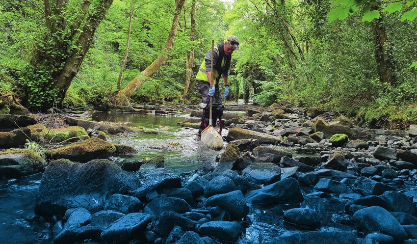
ENVIRONMENTAL PROTECTION AGENCY                                           Environmental Monitoring & Assessment
The EPA is responsible for protecting and improving the environment       • Design and implement national environmental monitoring systems:
as a valuable asset for the people of Ireland. We are committed to          technology, data management, analysis and forecasting;
protecting people and the environment from the harmful effects of         • Produce the State of Ireland’s Environment and Indicator Reports;
radiation and pollution.                                                  • Monitor air quality and implement the EU Clean Air for Europe
                                                                            Directive, the Convention on Long Range Transboundary Air
The work of the EPA can be divided into three main                          Pollution, and the National Emissions Ceiling Directive;
areas:                                                                    • Oversee the implementation of the Environmental Noise Directive;
Regulation: Implementing regulation and environmental compliance          • Assess the impact of proposed plans and programmes on the Irish
systems to deliver good environmental outcomes and target those who         environment.
don’t comply.
Knowledge: Providing high quality, targeted and timely environmental      Environmental Research and Development
data, information and assessment to inform decision making.               • Coordinate and fund national environmental research activity to
Advocacy: Working with others to advocate for a clean, productive and       identify pressures, inform policy and provide solutions;
well protected environment and for sustainable environmental practices.   • Collaborate with national and EU environmental research activity.

Our responsibilities include:                                             Radiological Protection
                                                                          • Monitoring radiation levels and assess public exposure to ionising
Licensing                                                                   radiation and electromagnetic fields;
• Large-scale industrial, waste and petrol storage activities;            • Assist in developing national plans for emergencies arising from
• Urban waste water discharges;                                             nuclear accidents;
• The contained use and controlled release of Genetically Modified        • Monitor developments abroad relating to nuclear installations and
  Organisms;                                                                radiological safety;
• Sources of ionising radiation;                                          • Provide, or oversee the provision of, specialist radiation protection
• Greenhouse gas emissions from industry and aviation through the           services.
  EU Emissions Trading Scheme.
                                                                          Guidance, Awareness Raising, and Accessible
National Environmental Enforcement                                        Information
• Audit and inspection of EPA licensed facilities;                        • Provide independent evidence-based reporting, advice and
• Drive the implementation of best practice in regulated activities         guidance to Government, industry and the public on environmental
  and facilities;                                                           and radiological protection topics;
• Oversee local authority responsibilities for environmental              • Promote the link between health and wellbeing, the economy and
  protection;                                                               a clean environment;
• Regulate the quality of public drinking water and enforce urban         • Promote environmental awareness including supporting behaviours
  waste water discharge authorisations;                                     for resource efficiency and climate transition;
• Assess and report on public and private drinking water quality;         • Promote radon testing in homes and workplaces and encourage
                                                                            remediation where necessary.
• Coordinate a network of public service organisations to support
  action against environmental crime;                                     Partnership and networking
• Prosecute those who flout environmental law and damage the              • Work with international and national agencies, regional and
  environment.                                                              local authorities, non-governmental organisations, representative
                                                                            bodies and government departments to deliver environmental and
Waste Management and Chemicals in the Environment                           radiological protection, research coordination and science-based
• Implement and enforce waste regulations including national                decision making.
  enforcement issues;
                                                                          Management and structure of the EPA
• Prepare and publish national waste statistics and the National
  Hazardous Waste Management Plan;                                        The EPA is managed by a full time Board, consisting of a Director
                                                                          General and five Directors. The work is carried out across five Offices:
• Develop and implement the National Waste Prevention Programme;
                                                                          • Office of Environmental Sustainability
• Implement and report on legislation on the control of chemicals in
  the environment.                                                        • Office of Environmental Enforcement
                                                                          • Office of Evidence and Assessment
Water Management
                                                                          • Office of Radiation Protection and Environmental Monitoring
• Engage with national and regional governance and operational
                                                                          • Office of Communications and Corporate Services
  structures to implement the Water Framework Directive;
• Monitor, assess and report on the quality of rivers, lakes,             The EPA is assisted by advisory committees who meet regularly to
  transitional and coastal waters, bathing waters and groundwaters,       discuss issues of concern and provide advice to the Board.
  and measurement of water levels and river flows.

Climate Science & Climate Change
• Publish Ireland’s greenhouse gas emission inventories and
  projections;
• Provide the Secretariat to the Climate Change Advisory Council and
  support to the National Dialogue on Climate Action;
• Support National, EU and UN Climate Science and Policy development
  activities.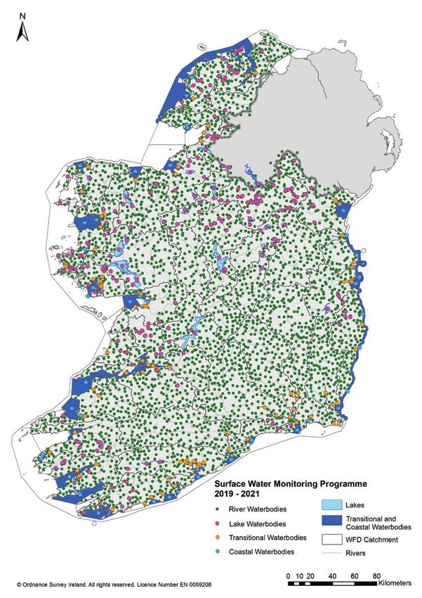
I re l a n d ’s N atio n a l Wate r Fra m ewo r k D i re c ti ve M o n ito ri n g P ro g ra m m e 2019 - 2021

                                                                                                                    Ireland ’s National
                                                                                                                Water Framework D irec tive
                                                                                                                 Monitoring Pro gramme
                                                                                                                        2019 –2021

                                                                                                                        ENVIRONMENTAL PROTECTION AGENCY
                                                                                                                      An Ghníomhaireacht um Chaomhnú Comhshaoil
                                                                                                                   PO Box 3000, Johnstown Castle, Co. Wexford, Ireland
                                                                                                                   Telephone: +353 53 916 0600 Fax: +353 53 916 0699
                                                                                                                          Email: info@epa.ie Website: www.epa.ie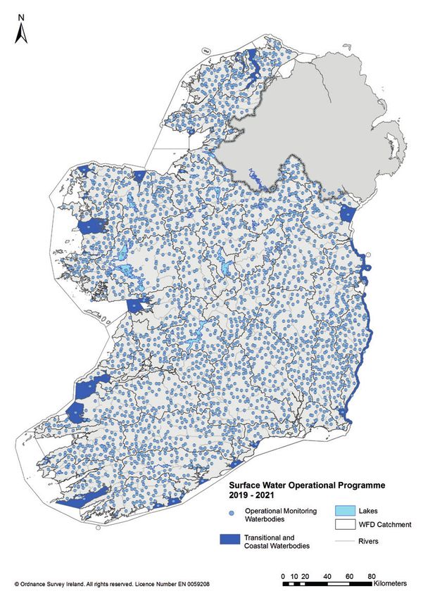
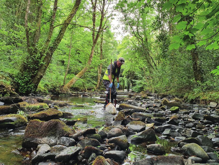
Report published by Environmental Protection Agency, Ireland

Acknowledgements
The Environmental Protection Agency wishes to express its thanks to the following
organisations who contributed material to this report: Inland Fisheries Ireland, Marine
Institute, National Parks and Wildlife Service and Waterways Ireland.

Main cover photo: The river Owenass, Co. Offaly. Photo: Hugh Feeley

© Environmental Protection Agency 2021

Although every effort has been made to ensure the accuracy of the material contained
in this publication, complete accuracy cannot be guaranteed. Neither the Environmental
Protection Agency nor the author(s) accepts any responsibility whatsoever for loss
or damage occasioned, or claimed to have been occasioned, in part or in full as a
consequence of any person acting or refraining from acting, as a result of a matter
contained in this publication. All or part of this publication may be reproduced without
further permission, provided the source is acknowledged.

ISBN 978-1-84095-974-1
Environmental Protection Agency | Ireland’s National Water Framework Directive Monitoring Programme 2019 - 2021

Table of Contents
1. 	   INTRODUCTION		                                                                                          7

2. 	   THE REVIEW PROCESS		                                                                                   10

3. 	   KEY FINDINGS 		                                                                                        16
       3.1 	 Providing a national picture of water status                                                     16

               3.1.1   Structure of the surveillance and operational networks                                 16
               3.1.2   Achieving a complete national picture of water status                                  17
       3.2 	 Links to the characterisation of risk and significant pressures                                  18

       3.3 	 Making the programme more dynamic and responsive to environmental change                         18

               3.3.1   Measuring change resulting from measures                                               18
               3.3.2 Responding to environmental change                                                       19
               3.3.3 Climate change and water status assessment                                               19
               3.3.4 Acid sensitive area monitoring of rivers                                                 20
       3.4 	 Links to Catchment Assessments and Priority Areas for Action                                     20

       3.5 	   Monitoring the right biological quality element in the right place                             21

       3.6 	 Monitoring of chemical and general physico-chemical elements                                     23

               3.6.1 Priority substances Monitoring                                                           23
               3.6.2 Physico-chemical monitoring                                                              25
       3.7 	 Hydromorphology                                                                                  29

4. 	   THE NATIONAL WFD MONITORING PROGRAMME 2019-2021                                                        30
       4.1 	 Surveillance and operational networks and subnetworks                                            34

       4.2 	 Frequency and parameters of monitoring                                                           37

               4.2.1   Surface waters                                                                         37
               4.2.2 Groundwaters                                                                             37
       4.3     Canals 		                                                                                      40

5. 	   DATA MANAGEMENT AND REPORTING		                                                                        41
       5.1  Quality control and quality assurance                                                             41

       5.2     Confidence and precision in classification                                                     42

6. 	   INCREASE USE OF TECHNOLOGY		                                                                           43

7. 	   RESPONSIBILITY OF PUBLIC AUTHORITIES		                                                                 44

8. 	   COMPARISON TO MONITORING IN OTHER EU MEMBER STATES AND UK                                              45

9. 	   UPDATING THE PROGRAMME		                                                                               46

10. 	 REFERENCES		                                                                                            47

                                                       v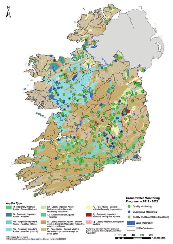
Environmental Protection Agency | Ireland’s National Water Framework Directive Monitoring Programme 2019 - 2021
List of Tables
Table 1: List of operational subnetworks in the revised programme 18
Table 2: Number of monitored water bodies in each water category in a Priority
Area for Action 21
Table 3: Biological assessment methods used to assess ecological status in each water
category in the national WFD programme 2019-2021 (Italics indicate new
method or method under development) 22
Table 4: Priority substances and priority hazardous substances (italicised) listed in the
Priority Substances Directive (2013/39/EC) together with an indication of the
substances and matrices being monitored in the national WFD monitoring
programme 24
Table 5: Number of river sites monitored for biology and physico-chemical elements
(and overlap) in the 2019-2021 programme 26
Table 6: Number of water bodies in each monitoring network by water category
in the national WFD monitoring programme 2019-2021 30
Table 7: Number of water bodies in each surveillance subnetwork common to
all surface water categories in the national WFD monitoring programme 2019-2021 34
Table 8: Number of water bodies in each operational subnetwork by surface water
category in the national WFD monitoring programme 2019-2021. 34
Table 9: Frequency of monitoring for each quality element in the national surface waters
WFD monitoring programme 2019-2021 38
Table 10: Nominated authorities for elements of the surveillance and operational
monitoring programmes 44
List of Maps
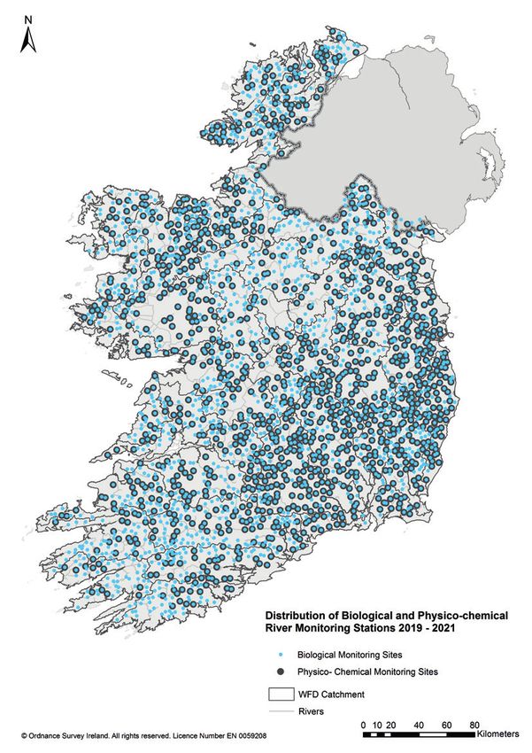
Map 1: Distribution of biological and physico-chemical river monitoring stations 2019-2021 27
Map 2: Distribution of the surface water monitoring programme 2019-2021 32
Map 3: Distribution of the groundwater monitoring programme 2019-2021 33
Map 4: Distribution of the surface water surveillance monitoring network 2019-2021 35
Map 5: Distribution of the surface water operational monitoring network 2019-2021 36
Map 6: Distribution of the canals monitoring network on the Royal and Grand Canals 40
List of Figures
Figure 1: Distribution of risk across each of the five individual water categories 10
Figure 2: Change in ecological status since the first river basin management cycle
2007-2009. Number of water bodies in parentheses 12
Figure 3: Representation of national river typologies defined in the rivers
monitoring programme 13
Figure 4: Representation of risk in the rivers monitoring programme by river catchment. 14
Figure 5: Representation of significant pressures in the rivers monitoring programme 15
Figure 6: Comparison of Ireland’s national monitoring programme for surface waters against
the UK and 23 European member states. Data obtained from the EU Commissions
first assessment of member states’ programmes for monitoring of water status
(COM (2009) 156) 45
vi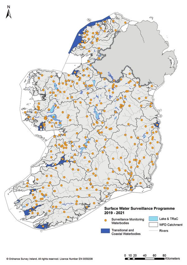
Environmental Protection Agency | Ireland’s National Water Framework Directive Monitoring Programme 2019 - 2021

Executive Summar y
      This document presents Ireland’s national Water Framework Directive (WFD) monitoring
      programme for the period 2019-2021. The main purpose of the programme is to provide
      a coherent and comprehensive national overview of the ecological and chemical status of
      surface waters (rivers, lakes, transitional and coastal waters) and the quantitative and chemical
      status of groundwaters. This information is used, amongst other things, to track progress
      towards the achievement of the environmental objectives established in Ireland’s national
      River Basin Management Plan (RBMP) and to assess change in the quality of Ireland’s aquatic
      environment over time.
      The structure and content of the 2019-2021 monitoring programme is based on a review of
      the existing monitoring programme which has been in place since 2006. The main changes to
      the programme arising from the review are set out in this document. This document provides
      a general description of the type of monitoring to be undertaken, the number of water
      bodies in each water category to be monitored and the frequency of that monitoring. Specific
      information on individual water bodies in terms of the environmental quality elements to be
      monitored and the frequency of this monitoring is provided to public authorities electronically
      via the Water Framework Directive Application (WFDApp).

The National Monitoring Programme 2019-2021
      The national WFD monitoring programme for Ireland for the period 2019-2021 is comprised
      of 3,169 surface and groundwater bodies. This represents 66% of the total number of water
      bodies nationally (4,829). This includes 2,422 river water bodies, 224 lakes, 84 transitional
      water bodies, 47 coastal waters and 392 groundwater bodies. In addition, there are 159 sites
      used to assess groundwater quantitative status. The location nationally of monitored surface
      water and groundwater bodies is shown below.
      The programme includes two main types of monitoring networks. A surveillance monitoring
      network to provide a comprehensive and long-term picture of water body status across the
      State and an operational network to assess the status of water bodies at risk of failing to
      meet their environmental objectives and to assess if a change in the status of a water body
      is the result of a programme of measures. There are 287 surface water bodies and 259
      groundwater bodies in the surveillance monitoring network and 2418 surface water bodies
      and 133 groundwater bodies in the operational monitoring network. The location of surface
      and groundwater bodies in the national programme is shown below while the location of
      individual monitoring stations can be viewed on EPA Maps (https://gis.epa.ie/EPAMaps/).

        Type of                 Rivers        Lakes         Transitional         Coastal     Groundwater
        Monitoring                                              Waters           Waters
        Surveillance               179             75                23                 9                 259
        Operational              2243            149                 61                38                 133
        Quantity                                                                                        (159)
        Total                    2422            224                 84                47                392

                                                        1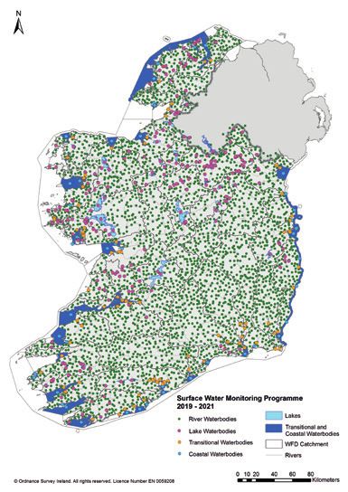
Environmental Protection Agency | Ireland’s National Water Framework Directive Monitoring Programme 2019 - 2021

       The surveillance and operational networks are further divided into subnetworks designed to
       meet specific monitoring objectives. For example, in the surveillance network, the long-term
       trend subnetwork is designed to detect trends in water status, whereas in the operational
       networks, a number of subnets have been specifically designed to assess if changes in water
       body status are a result of measures to address different significant pressures.
       The surveillance network is assigned into four subnetworks common to all surface water
       categories as was the case in the previous programme. The operational network is assigned
       into 14 subnetworks: 12 of these are related to significant pressures identified in the RBMP
       characterisation process, one is designed to assess the effectiveness of measures to protect
       and restore high and good status water bodies, and one is for protected areas at risk.
       The number of water bodies in each of the operational subnetworks reflects the importance of
       that pressure with the highest number of water bodies are in the agriculture, hydromorphology
       and urban waste water subnetworks. An individual water body can be represented in more
       than one subnet if that water body is being impacted by more than one pressure.
       The number of water bodies in each of the surveillance and operational sub-networks in the
       national monitoring programme 2019-2021 is shown below.

         Surveillance Subnet                        Rivers            Lakes       Transitional       Coastal
                                                                                      Waters         Waters
         1. Representative of overall                   179               75                 23             9
            status
         2. Long-term trends                            179               75                   9            4
         3. Validating the risk                             23            75                   3            0
            assessment
         4. Stipulated sites in the WFD                     25            56                   7            0

                                                        2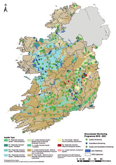
Environmental Protection Agency | Ireland’s National Water Framework Directive Monitoring Programme 2019 - 2021

       Operational Sub network                      Rivers        Lakes        Transitional        Coastal
       1. Agriculture                                  603            75                  39               8
       2. Aquaculture                                      5           0                    3              3
       3. Domestic Waste Water                         131            14                    6              0
       4. Extractive Industry                          153             5                    0              0
       5. Forestry                                     215            17                    0              0
       6. Historically Polluted Sites                      5           0                    0              0
       7. Hydromorphology                              329            16                    0              3
       8. Discharges                                      86           3                    0              1
       9. Invasive Species                                 7          34                    0              0
       10. Anthropogenic Pressures                        68           6                    2              2
           Other
       11. Urban Run-off                               116             2                    2              0
       12. Urban Waste Water                           244            14                   24             12
       13. Protected Areas At Risk                     445            44                   12              2
       14. Protect high and good                       842            80                   10             21
           status water bodies

Qualit y Elements to be Monitored and Frequency
      This document sets out the quality elements (biological, physico-chemical and
      hydromorphological) to be monitored and the frequency of this monitoring. All biological
      elements, with the exception of phytoplankton in rivers (not sufficiently sensitive) are being
      monitored, together with the majority of general physico-chemical elements and specific
      pollutants. Twenty-three and 36 priority substances listed in the 2013 Priority Substances
      Directive are being monitored in inland surface waters and marine waters, respectively. All
      groundwater quantitative and chemical quality elements are being monitored in the national
      groundwater programme. All quality elements are monitored at least at the minimum
      frequency recommended in the Directive.

The Review Findings
      The main findings of the review have been incorporated into the national WFD monitoring
      programme for the period 2019-2021. The changes include structural changes to the
      operational network, increased monitoring frequencies at specified sites (high status sites at
      risk, Priority Areas for Action, sites damaged by pollution, etc), increased overlap between
      the river physico-chemical and biological monitoring networks and the addition of new water
      bodies and monitoring sites in Priority Areas for Action.
      The main structural change to the programme is the increase in the number of operational
      subnets which have increased from five to 14. This change has been made to better align
      the operational network with the outcome of the RBMP characterisation process. Improved
      representation and closer alignment of the operational subnets with the significant pressures
      identified during characterisation will ensure that the impacts arising from these pressures are
      being monitored and addressed in the programme of measures.

                                                      3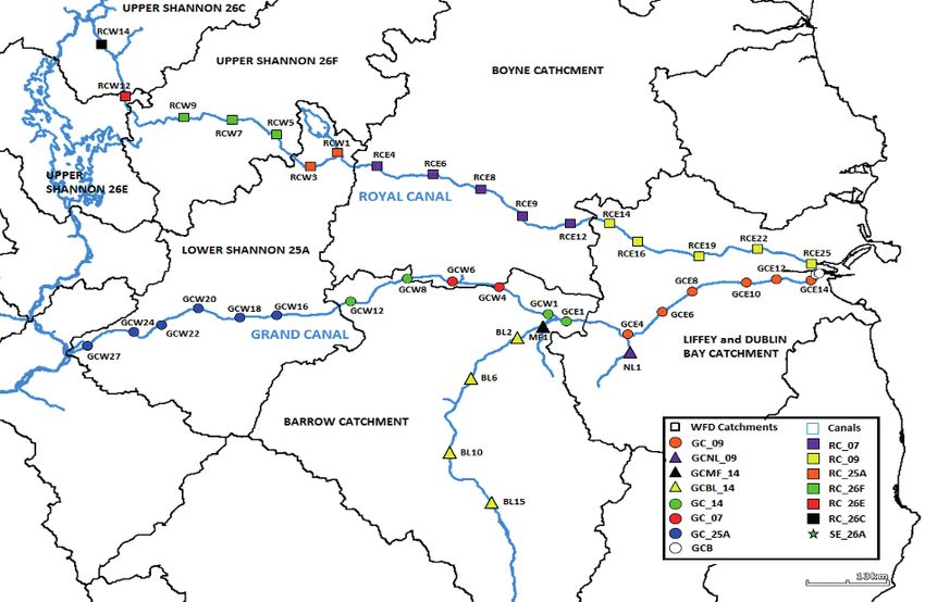
Environmental Protection Agency | Ireland’s National Water Framework Directive Monitoring Programme 2019 - 2021

       The review has highlighted the need to make the programme more dynamic and responsive
       to environmental change. This has been achieved by increasing the frequency of monitoring at
       sites which have been damaged by pollution or are at risk of not meeting their environmental
       objectives. These sites include high status water bodies that are at risk of deterioration, or
       that have already deteriorated and water bodies that have been impacted by suspected toxic
       (chemical pollution) events. To make the programme more dynamic, consideration will be
       given to the removal of water bodies from the operational network once their objectives have
       been met and can be maintained and to redeploy this monitoring resource elsewhere.
       The overlap between the national programme and the 190 Priority Areas for Action identified
       in the national RBMP has been improved by adding new water bodies and monitoring
       sites. The frequency and timing of monitoring has also been adapted to help assess the
       effectiveness of measures and to confirm if a water body has met its environmental objective
       by the prescribed date.
       The general changes to the programme together with the specific changes for individual
       water categories following the outcome of the review are:

General changes
           \ Increase in the number of operational subnetworks from five to 14 for surface waters
             to better align with the significant pressures identified in the RBMP characterisation
             process.
           \ Increase in the frequency of monitoring at priority sites (i.e. high status water bodies,
             polluted sites, sites in Areas for Action) to detect change that may result from
             pressures or the implementation of measures.
           \ Stronger links between the monitoring programme and Priority Areas for Action
             through the addition of new water bodies and increase in monitoring frequency.

Specific changes
       Rivers
           \ Increased alignment between the rivers physico-chemical and biological monitoring
             networks to achieve a more spatially integrated assessment of ecological status.
           \ Increased frequency of monitoring of high status sites at risk of not meeting their
             environmental objectives and those which have already deteriorated including annual
             monitoring at the remaining highest quality sites (Q5).
           \ Increased frequency of monitoring at sites suspected of being impacted by toxic
             events including annual monitoring until improvement in status is detected.
           \ Establishment of an acid sensitive area network to assess the impact of acidification.
           \ Establishment of a WFD specific climate change network to understand the effects
             of climate change on macroinvertebrate communities, reference condition and
             assessment.
       L akes
           \ The review found that the lakes monitoring programme was sufficiently robust to
             provide an overall national picture of lake water status.
           \ At the catchment-scale the review indicated the lakes programme could be more
             representative of certain typologies and pressures. A series of projects will be
             undertaken to inform a full review of the programme in time for the next river basin
             cycle.
           \ Reduced monitoring frequency of fish in lakes with slow response times.

                                                        4
Environmental Protection Agency | Ireland’s National Water Framework Directive Monitoring Programme 2019 - 2021
Transitional and coastal
\ The transitional and coastal waters monitoring programme was found to be generally
fit for purpose.
\ A number of water bodies now identified as Priority Areas for Action, but previously
unmonitored, have been added to the programme (e.g. Bannow Bay).
\ The boundaries of six water bodies have been adjusted to better reflect their status
and the environmental drivers of status.
Groundwater
\ The groundwater monitoring programme was found to be generally fit for purpose.
\ Increase in the number of water bodies being monitored in the operational network.
A slight decrease in the surveillance network.
Assignment of Responsibilit y for WFD monitoring
The monitoring programme lists the elements that each Public Authority has responsibility
for and there is a statutory obligation on the nominated authority to execute the monitoring
assigned to them. The assignment of a monitoring responsibility to a public authority (like in
the previous programme) is based on the established responsibilities and competency of the
public authority. For the biological, hydromorphological and physicochemical parameters, the
assigned Public Authorities have been involved in the assessment of these parameters for
several decades.
The EPA is now undertaking all the surveillance and operational freshwater chemical
monitoring with local authorities undertaking the sampling for these networks. The table
below sets out the nominated authorities for each element of the monitoring programme.
Nominated authorities for elements of the surveillance and operational monitoring programmes
Element Rivers Lakes Transitional Ground Canals Data Reporting
and Coastal Water Processing
Phytoplankton - LA, EPA, MI - - EPA EPA
EPA
Macrophytes EPA EPA EPA - WI EPA EPA
Benthic Algae EPA EPA - - - EPA EPA
Macroinvertebrates EPA EPA MI - WI EPA EPA
Fish IFI IFI IFI - IFI IFI EPA
Hydromorphology EPA, EPA EPA, MI - EPA, EPA EPA
OPW WI
Physico-Chemical LA, EPA LA, EPA, MI EPA WI EPA EPA
EPA
Relevant Pollutants LA, EPA LA, MI EPA - EPA EPA
EPA
Priority Substances LA, EPA LA, MI EPA - EPA EPA
EPA
(EPA: Environmental Protection Agency; LA: Local Authority; IFI: Inland Fisheries Ireland;
MI: Marine Institute; OPW: Office of Public Works; WI: Waterways Ireland)
5Environmental Protection Agency | Ireland’s National Water Framework Directive Monitoring Programme 2019 - 2021
Updating the programme
The structure and content of the programme in place for the period 2019-2021 is available
to view electronically via the Water Framework Directive Application (WFDApp). Any changes
to the content of the programme for either operational or logistical reasons will be updated
on an annual basis as necessary. Changes to the programme will be made with the full
knowledge of the relevant public bodies.
The national WFD monitoring programme will be reviewed prior to the commencement of the
third-cycle river basin management plan 2022-2027.
6Environmental Protection Agency | Ireland’s National Water Framework Directive Monitoring Programme 2019 - 2021
1. Introduction
The main aim of the EU Water Framework Directive is to achieve good status in both surface
and groundwater bodies and the prevention of deterioration in water bodies that are already
in good or better status. Surface waters include rivers, lakes, transitional waters and coastal
waters. For natural waters these environmental objectives relate to achieving or maintaining
good or high ecological status and good chemical status for surface waters and good
chemical and quantitative status for groundwaters. For heavily modified or artificial water
bodies which are incapable of achieving good ecological status without impairing an existing
specified water use the environmental objective is to achieve good ecological potential.
A central component of the framework is the establishment in each member state of a
national monitoring programme to provide a coherent and comprehensive assessment
of water status in a river basin district. The programme is required to identify the type of
monitoring (e.g. surveillance, operational or investigative) to be undertaken and the objectives
under each type, the water bodies and quality elements to be monitored and the frequency
of this monitoring. The specific requirements to be met are explicitly given in Annex V of the
Directive.
The assessment of ecological status is based on biological quality elements as well as
supporting hydromorphological, chemical and physico-chemical quality elements while
chemical status is assessed against a range of environmental quality standards (EQSs) listed
in the WFD and subsequent Environmental Quality Standard Directives. For groundwaters,
both quantitative and chemical status is assessed. The assessment of quantitative status is
based on groundwater level measurements and the assessment of chemical status is based
on measurements of conductivity and concentrations of pollutants.
Ireland’s national WFD monitoring programme was established in 2006 (EPA, 2006) in
accordance with the requirements of the European Communities (Water Policy) Regulations,
2003. The original programme was designed to meet the specific monitoring requirements
of the WFD and to support the implementation of the first river basin management cycle in
Ireland. The programme was designed to provide a representative picture of water quality
status in each river basin district and to assess the effectiveness of measures put in place to
achieve the environmental objectives set out in each of the river basin management plans. The
programme also took into consideration the monitoring requirements of other water related
environmental legislation such as the Nitrates Directive.
The programme consists of two main monitoring networks: a surveillance network to provide
a comprehensive and long-term picture of water status across the State and an operational
network to assess the status of those waters at risk of not meeting their environmental
objectives and to assess if the status of a water body changes as a result of a programme
of measures. These networks are further divided into subnetworks which are designed
to meet the specific requirements of the Directive. A third type of monitoring, known as
investigative, is undertaken on an ad-hoc basis. The purpose of each of these networks and
the subnetworks associated with them is explained in Topic Box 1.
7Environmental Protection Agency | Ireland’s National Water Framework Directive Monitoring Programme 2019 - 2021
Box 1. Structure of the national WFD monitoring programme 20 06 -2018
The national WFD monitoring programme for surface water was divided into three main
monitoring networks, surveillance, operational and investigative, each of which were designed
to meet one or more objectives of the WFD.
The surveillance monitoring network was established to provide information for:
\ supplementing and validating the impact assessment procedure,
\ the efficient and effective design of future monitoring programmes,
\ the assessment of long-term changes in natural conditions, and
\ the assessment of long-term changes resulting from widespread anthropogenic
activity.
The purpose of operational monitoring network was to:
\ establish the status of those bodies identified as being at risk of failing to meet their
environmental objectives, and
\ assess any change in the status of such bodies resulting from the programmes of
measures.
Investigative monitoring is required where the reason for any exceedance is unknown or
to ascertain the extent and impact of accidental pollution. IM can also be used to help select
measures needed to achieve environmental objectives or to remedy the effects of accidental
pollution.
For the surveillance network four subnetworks were established: 1. to be representative
of overall status within a catchment or sub-catchment; 2. to detect long-term trends; 3. to
supplement and validate the risk assessment and 4. for specific sites or water bodies stipulated
in the Directive: e.g. points on large rivers where the catchment area upstream is greater than
2,500 km2).
For the operational network five subnetworks were established to assess the effectiveness
of measures to: 1. reduce impact on status from point sources; 2. reduce impact on status
from diffuse sources; 3. reduce impact on status from hydromorphological pressures; 4. to
maintain good and high status water bodies; and 5. monitor protected areas at risk.
The groundwater quality monitoring programme includes:
\ a surveillance monitoring network to supplement and validate the risk assessment
with respect to the risks of failing to achieve good chemical status and natural and
anthropogenic trend assessments;
\ an operational monitoring network to establish the status of at risk groundwater
bodies and establish the presence of significant upward trends in the concentration
of pollutants;
\ appropriate monitoring to support the objectives of the Drinking Water Protected
Areas and Protected Areas for species and habitats.
The quantitative groundwater monitoring programme is required to:
\ supplement and validate the Annex II risk assessment procedure;
\ determine the quantitative status of groundwater bodies;
\ support the chemical status assessment and trend analysis;
\ support the design and evaluation of programmes of measures.
8Environmental Protection Agency | Ireland’s National Water Framework Directive Monitoring Programme 2019 - 2021
The publication of Ireland’s second-cycle River Basin Management Plan (2018-2021) provided
an opportunity to review the national WFD monitoring programme. The review considered
the changes required to the programme to ensure it continues to meet the requirements of
the Directive and related legislation and to support the implementation of the second-cycle
RBMP across Ireland’s single national River Basin District.
The review was informed by the outputs of the characterisation exercise undertaken in
preparation for the second-cycle RBMP and by improved knowledge of the state of Ireland’s
aquatic environment that has resulted from on-going monitoring, outputs from research
projects and the development and use of new biological and chemical assessment methods.
The review has also taken into account the 190 Priority Areas for Action identified for special
attention in the RBMP.
The purpose of this document therefore is to summarise the main findings of the review and
to present the structure and content of the revised national WFD monitoring programme for
Ireland for the period 2019-2021. The document also specifies and reiterates the nature and
extent of monitoring to be undertaken by the relevant public authorities. The programme
described in this document updates and replaces the programme established by the EPA in
2006.
The specific details of the programme in terms of lists of water bodies to be monitored in
each water category, the quality elements to be monitored and their frequency is provided on
the WFD Application which is accessible through the Environmental Data Exchange Network
(www.edenireland.ie). The location of national monitoring stations can be viewed on EPA
Maps (https://gis.epa.ie/EPAMaps/).
9Environmental Protection Agency | Ireland’s National Water Framework Directive Monitoring Programme 2019 - 2021
2. THE REVIEW PROCESS
This section provides a description of the review process and a summary of the different types
of information used. The main purpose of the review was to assess if the programme was still
fit for purpose and capable of delivering the required outputs for the implementation of the
second-cycle river basin management plan.
The key findings of the review (see sections 3 and 4) have been incorporated into the national
WFD monitoring programme for the period 2019-2021.
The review examined the existing surveillance and operational networks and associated
subnetworks to assess if they had been effective in assessing the overall national status of
surface waters and groundwaters and in assessing change in water status resulting from the
programmes of measures. The review also examined the extent to which the programme is
aligned to the risk characterisation process completed in 2017 in preparation for the second-
cycle RBMP. The extent to which the programme is aligned to the characterisation process and
each of the three risk characterisation categories (at risk, not at risk, review) gives an indication
of how effective the programme will be in continuing to address the significant pressures
impacting on water status in Ireland. Finally, the review examined how closely the monitoring
programme overlapped with the Priority Areas for Action that have been selected for special
attention in the second-cycle river basin management plan.
1183 1321 688
River
132
132 422 264
Lake
56 59 80
Transitional
13
Coastal 13 64 34
75
75 247 191
Groundwater
0 20 40 60 80 100
Percentage (%) of water bodies
At Risk Not at Risk Review
Figure 1: Distribution of risk across each of the five individual water categories
In summary, the review considered if the national programme was:
1. Effective in assessing water status (i.e. representative of water body typology, risk,
significant pressures and status);
2. Responsive to environmental change (as a result of measures but also due to
environmental pressures);
3. Aligned with the outcome of the characterisation process;
4. Linked to Priority Areas for Action.
10Environmental Protection Agency | Ireland’s National Water Framework Directive Monitoring Programme 2019 - 2021
In undertaking the review the following information was taken into account:
\ Any change or updates to the national typology of surface water and groundwaters.
The typology used to group individual water bodies into types that reflect their
physical character has remained mostly unchanged. A new type was added for
lakes bringing the total number of types to 13. A much larger proportion of lakes
have now been categorised into their national physical type. The review process has
examined if all physical types are adequately represented in the programme.
\ Any change to the delineation of water body boundaries. This was particularly
relevant for rivers as all original river body boundaries were re-delineated to better
align with the river monitoring network. This also required that these newly
delineated river water bodies were re-typed and this has been undertaken in the
review of the rivers monitoring network.
\ The outcome of the risk characterisation process for surface water and
groundwater which categorised water bodies into three categories: not at risk; at
risk and review. Each of these risk categories have implications for the design of
the monitoring programme in terms of the need for additional measures for “at risk”
water bodies or the maintenance of basic measures for water bodies “not at risk”
or the need for further monitoring or investigative assessments of “review” water
bodies. The existing programme was reviewed against each of these categories to
assess how representative the programme was of each risk category (Figure 1).
\ The identification of significant pressures as part of the risk characterisation
process which provides the means to target local measures. The review examined the
effectiveness of the existing programme and the effectiveness of the operational sub-
networks in assessing the impact of these pressures.
\ For groundwater, updated information on hydrogeology and pollution impact
potential maps for phosphorus and nitrogen.
\ For groundwater, updated delineation of the area of a catchment contributing water
to a groundwater monitoring point (i.e. zone of contribution).
\ Development of the catchment assessments approach and identification of
Priority Areas for Action.
\ The setting of dates for the achievement of environmental objectives. The review
took into consideration if monitoring would be undertaken in time to confirm
if planned improvements had been achieved especially where there is a 2021
environmental objective deadline.
\ The ecological status and chemical status of surface waters and groundwaters.
Information on water status was used to examine the overall representativeness of
the programme with change in water status used to assess the ability of the existing
programme to assess long-term change as well as sudden change in ecological status
(Figure 2). The review examined if the existing programme was suitable for assessing
the nature and cause of these changes both in space and time. (i.e. is the frequency
and spatial distribution at which some elements monitored sufficient to detect
change and response to measures).
11Environmental Protection Agency | Ireland’s National Water Framework Directive Monitoring Programme 2019 - 2021
%
50
43.8 44.6 44.2
Percentage of Water Bodies
40
28.3
30 27.1 26.7
20 17.9
16.9
14.8
12.9
10.8
8.5
10
1.4 1.1 1.0
0
High Good Moderate Poor Bad
2007-2009 (2503) 2010-2015 (2693) 2013-2018 (2703)
Figure 2: Change in ecological status since the first river basin management cycle 2007-2009.
Number of water bodies in parentheses.
\ The inclusion of new biological assessment methods and the requirement to monitor
new physico-chemical parameters including newly identified priority substances and
priority hazardous substances.
\ The inclusion of water bodies stipulated in the text of the WFD (e.g. sites used to
estimate the pollutant load to the marine environment; sites identified under the
Information Exchange Network (EIONET), significant cross border water bodies).
\ Integration across each of the water categories. For example, monitoring linkages
between different water categories (e.g. rivers and lakes) to assess the broadscale
effect of measures or indeed anthropogenic pressures.
\ Integration and synergies with other national monitoring programmes (e.g.
combining monitoring of WFD coastal water bodies with monitoring of shellfish
waters, links to monitoring for Marine Strategy Framework Directive, OSPAR).
\ Practical considerations such as site access, health and safety considerations,
presence or absence of particular biological elements or habitats, etc.
This information was evaluated to answer each of the four questions outlined above. As an
example of the type of analysis undertaken, Figures 3, 4 and 5 show the extent to which the
national rivers monitoring network represents the range of typologies, risk and significant
pressures respectively that occur across Ireland’s entire rivers network. The extent to which
the rivers programme represents each of these features provides an indication of how well the
programme represents overall water status across this category. Other analyses were carried
out to examine how responsive the programme is to environmental change, how well the
programme aligns with the outcome of the risk characterisation exercise and lastly the extent
of the overlap between the programme and the Priority Areas for Action. A similar exercise
was carried out for each of the water categories.
1243
11
312
12
266
13
357
River Typology 14
6
21
99
22
56
102
23
124
24
628
31
744
32
328
33
157
34
0 100 200 300 400 500 600 700 800
No. of water bodies
All river water bodies (n = 3,166) Monitored river water bodies (n = 2,331)
Figure 3: Representation of national river typologies defined in the rivers monitoring programme.
13Environmental Protection Agency | Ireland’s National Water Framework Directive Monitoring Programme 2019 - 2021
All Water Bodies Monitored Water Bodies
137
Total 1184 1321 687 Total 1138 1171
40 40
39 39
38 38
37 37
36 36
35 35
34 34
33 33
32 32
31 31
30 30
29 29
28 28
27 27
26 26
25 25
24 24
23 23
22 22
21 21
20 20
19 19
18 18
17 17
16 16
15 15
14 14
13 13
12 12
11 11
10 10
9 9
8 8
7 7
6 6
3 3
1 1
0 20 40 60 80 100 0 20 40 60 80 100
Percentage (%) of water bodies
At Risk Not at Risk Review
Figure 4: Representation of risk in the rivers monitoring programme by river catchment.
14Environmental Protection Agency | Ireland’s National Water Framework Directive Monitoring Programme 2019 - 2021
All river water
bodies At Risk
Monitored river
water bodies At Risk
Surveillance river
water bodies At Risk
0 10 20 30 40 50 60 70 80 90 100
Proportion (%) of each significant pressure in each river network
Agriculture Hydromorphology Urban Waste Water
Forestry Extractive Industry Domestic Waste Water
Urban Run-off Discharges Anthropogenic Pressures
Invasive Species Historically Polluted Sites Aquaculture
Figure 5: Representation of significant pressures in the rivers monitoring programme.
15Environmental Protection Agency | Ireland’s National Water Framework Directive Monitoring Programme 2019 - 2021
3. KEY FINDINGS
The key findings of the technical review will be summarised in the following sections. These
sections will clearly indicate the changes that have been incorporated into the 2019-2021
monitoring programme. The text will also indicate further work and other changes that are
likely to be made for future monitoring cycles.
3.1 Providing a national picture of water status
The main objective of the WFD national monitoring programme is to provide a national
picture of water status. This is achieved by collecting information on the status of a range
of biological, physico-chemical, hydromorphological and groundwater quality elements
from water bodies in the surveillance and operational networks. In addition to using this
information to assess water status it can also be used to provide extrapolated status to groups
of unmonitored water bodies which share similar characteristics to those which are monitored.
Combining status information from monitored and extrapolated water bodies provides an
overall national picture of water body status.
3.1.1 Structure of the sur veillance and operational net works
The review has examined the structure and content of the existing surveillance and
operational networks and has concluded that these networks are generally, with some minor
adjustments, fit for purpose in providing a representative picture of water status across the
State. That is to say, the existing surveillance and operational networks are representative of
the main typologies, pressures and risk within each water category. While the programme
was found to be generally fit for purpose, the review did identify the need to re-structure
the operational network, specifically the operational subnetworks, and align them to the
significant pressures identified in the characterisation process. Furthermore, in the individual
water categories, the review identified the need to make some adjustments by adding water
bodies to address identified gaps or to adjust water body boundaries to ensure that their water
status represents their true condition. It also became clear for some water categories, that
further characterisation is required to inform further review of the monitoring programme.
In the rivers water category, the review has indicated that the number of surveillance water
bodies should be increased to better reflect the overall national picture. The review found
that the surveillance network was skewed towards water bodies at risk and at less than
good status. To address this, additional sites at high and good status, will be added to the
rivers surveillance network following consultation between the EPA and relevant authorities.
Furthermore, additional sites will be added to represent high altitude locations (i.e. > 200
meters above sea level) and 1st order streams. In total approximately 20 additional sites will
be considered by the EPA for inclusion in the river surveillance network over the period of the
2019-2021 programme.
In lakes, the review has indicated that further characterisation is required to inform the review
of the surveillance and operational networks for future cycles. The technical review found
that while the lake programme is representative of different types and pressures, nationally,
the combination of different lake types and pressures is not sufficiently represented at smaller
scales. The technical review concluded that further information is required to undertake a
comprehensive review of the national lake monitoring programme. To facilitate this, projects
will be undertaken between 2019 and 2021 in time for the third river basin management
plan which will take effect in 2022. These projects will collect information to confirm the risk
categorisation of “review” lakes to complete lake typology and to better align pressure sources
16Environmental Protection Agency | Ireland’s National Water Framework Directive Monitoring Programme 2019 - 2021
with hydrogeological pathways. This information will be analysed and used to improve both
the risk characterisation process and the extrapolation methodology for lakes. In addition,
a collaborative project, with the National Parks and Wildlife Service, will be undertaken to
further clarify the water related qualifying interests for protected habitats and species that
occur in marl and oligotrophic lakes.
In transitional and coastal waters, the review has indicated that the existing number of
individual water bodies in the surveillance and operational networks are sufficient to meet the
objective of those respective networks. Nevertheless, in a small number of water bodies, it
became evident that changes needed to be made to some water body boundaries to ensure
that their status accurately reflects their condition and not the influence and condition of an
adjacent water body. This is particularly relevant in transitional waters, where impacted water
bodies can influence the assessment of status in an adjacent water body if the boundaries are
not positioned correctly. The boundaries of six transitional water bodies in the Suir, Munster
Blackwater and Swilly estuaries have been adjusted to better reflect their ecological status
and these adjusted water body boundaries are being used in the 2019-2021 monitoring
programme.
For groundwaters, the review found that the existing network was still valid and only minor
adjustments were required in response to updated information. The review is recommending
further characterisation in a small number of areas where the conceptual understanding
used in the design of the network requires development or validation. The review identified
the need for a small number of new sites to replace those lost through cessation of
abstractions. There will be additional consideration of the adequacy of the network as further
characterisation of the groundwater bodies is carried out during the next river basin cycle, for
example as additional information is gathered through the catchment assessment process.
3.1. 2 Achieving a complete national picture of water status
The review has also identified the importance of grouping of water bodies, also referred to
as extrapolation, in providing an accurate picture of water status across Ireland’s national
river basin district. Extrapolation is particularly useful for the lake and coastal water
categories, where you have a large number of unmonitored water bodies that are similar
in physical character and experiencing similar anthropogenic pressures to water bodies that
are monitored. Status information from monitored water bodies can therefore be used to
extrapolate status to unmonitored water bodies. The review has shown that the most accurate
and complete picture of national water status can only be obtained by combining the results
from extrapolation with those from the operational and surveillance monitoring networks.
The outcome of the extrapolation exercise is validated with supplementary data where this
exists. For example, the winter nutrient data collected by the Marine Institute is used to
validate the extrapolation of coastal water bodies. The EPA also anticipates that information
obtained from remote sensing (e.g. from the Copernicus network of satellites) of important
environmental parameters will be used in the future to validate the results of extrapolation.
In addition, over the period of the 2019-2021 monitoring programme, the level of confidence
in the outcome of the extrapolation exercise will be improved by basing the extrapolation
exercise on the same information that is used in the risk characterisation process.
17Environmental Protection Agency | Ireland’s National Water Framework Directive Monitoring Programme 2019 - 2021
3.2 Links to the characterisation of risk and significant pressures
The characterisation exercise undertaken in preparation for the second-cycle RBMP was far
more detailed than previous characterisation exercises. Due to the availability of a far more
extensive dataset the characterisation exercise was able to identify the specific pressures
impacting on individual water bodies at risk of failing to meet their environmental objectives.
In total, 12 individual significant pressures were identified.
Each of these significant pressures has been allocated a separate operational subnetwork. This
will facilitate the tracking of improvements in status as a result of measures being taken. This
adjustment means that these subnetworks are aligned with the individual significant pressures
identified during the characterisation exercise.
This has resulted in the original number of operational subnetworks increasing from 5 to 12.
In addition, two further subnetworks have been added: one to assess the effectiveness of
measures to protect and restore high and good status water bodies; and one for protected
areas at risk. This brings the number of operational subnetworks to 14 (Table 1).
The operational subnetwork to protect and restore high and good status water bodies speaks
to one of the main aims of the WFD which is to prevent further deterioration in water quality
and the need to apply measures to prevent deterioration in this important group of water
bodies.
Table 1: List of operational subnetworks in the revised programme.
Operational subnetwork
1: Agriculture At risk 8: Discharges At risk
2: Aquaculture At risk 9: Invasive Species At risk
3: Domestic waste water at risk 10: Anthropogenic Pressures At risk
4: Extractive Industry At risk 11: Urban Run-off At risk
5: Forestry At risk 12: Urban Waste Water At risk
6: Historically Polluted Sites At risk 13: Protected Areas At risk
7: Hydromorphology At risk 14: Protect High and Good Status
3.3 Making the programme more dynamic and responsive to
environmental change
3. 3.1 Measuring change resulting from measures
The review has indicated that the operational network needs to be more dynamic in
measuring change that may result from measures. This has been achieved by increasing the
frequency of monitoring to allow for more timely assessment of improvements as they occur.
For example, in the 2019-2021 monitoring programme the frequency of river monitoring has
been increased in a number of Priority Areas for Action (see below). Similarly, monitoring has
been increased at sites which are recovering from pollution events, which is currently the case
for seriously polluted river sites (i.e. Red Dots) which are monitored on an annual basis until
quality improves.
Indeed, if measures have resulted in the environmental objectives of a water body being
met then consideration will be given in future iterations of the programme to remove that
water body from the operational network or extending the frequency of monitoring from
18Environmental Protection Agency | Ireland’s National Water Framework Directive Monitoring Programme 2019 - 2021
three to six years. If an operational site is to be dropped, then evidence is needed that the
improvements observed have become well established and are not temporary. This could be
verified by re-sampling the site the following year or in the following three-year cycle. If the
improvements are confirmed and the water body is not at risk, then the water body could
be removed from the operational network or the frequency of monitoring could be reduced.
3. 3. 2 Responding to environmental change
The results of the monitoring programme have indicated that significant changes in the quality
of Ireland’s environment have occurred in recent years. Some of these changes have been
positive, for example in rivers, there has been a substantial reduction in the number of bad
ecological status water bodies. Unfortunately, some of these changes have been negative,
such as the very worrying ten-fold decline in the number of highest quality river sites (a
subset of high status sites), down from over 500 sites in the late 1980s to only 20 presently
(EPA, 2019). In response, a national Blue Dot Catchments programme has been established to
support the protection and restoration of high status sites across all surface water categories.
In total, 319 high status objective river water bodies, 37 lakes, 12 transitional waters and 16
coastal waters have been identified.
To support the protection and restoration of high status objective river water bodies the
frequency of monitoring for macroinvertebrates has been increased in the 2019-2021
monitoring programme to every year or every other year for those high status objective sites
that are at risk of deterioration or for previous high status sites that have already deteriorated.
In addition, the remaining highest quality river sites (Q5 sites) are now being monitored on an
annual basis. Once high status sites are considered no longer at risk or for those sites that have
improved in status, and are no longer at risk, the frequency of monitoring can be returned to
normal levels following review. This additional monitoring effort will support the national Blue
Dot Catchment programme and the Priority Areas for Action.
Significant acute ecological impacts on river biology have also been detected by the
programme. In recent years, the occurrence of suspected toxic events has been steadily
increasing most notably in the north-west region of the country. This has been noted mainly
in the significant decline in macroinvertebrate species diversity and abundances at these sites.
It is suspected that the impacts observed are due to chemical pollution. Nationally, 63 sites
have suspected toxic-like impacts between the period 2013-2016 and most of these (51) are
in the north-west of the country. In the 2019-2021 monitoring programme the frequency
of monitoring at a subset of these locations has been increased from the current once every
three years to twice every year. Sampling will be undertaken in spring and summer to assess
if the toxic impacts are displaying any seasonal pattern. Additional monitoring of priority
substances has also been put in place at a number of these sites with the aim of better
characterising the nature of the chemical impact.
This increased level of monitoring will help characterise the nature of the biological impacts
and their recovery. This work will also closely align with the Catchment Assessment work as
several Priority Areas for Action are in this region.
3. 3. 3 Climate change and water status assessment
The need to understand the impact of climate change on the functioning of aquatic systems
and on the interpretation of water status has increased since the monitoring programme was
first put in place in 2006. Predictions of more extreme weather events, increasing water flows
and temperature fluctuations have the potential to impact on aquatic ecosystems through
19You can also read