PROF. T. G. SITHARAM CHAIRMAN, CENTRE FOR INFRASTRUCTURE, SUSTAINABLE TRANSPORT AND URBAN PLANNING (CISTUP), INDIAN INSTITUTE OF SCIENCE ...
←
→
Page content transcription
If your browser does not render page correctly, please read the page content below

Prof. T. G. SITHARAM
Chairman, Centre for infrastructure, Sustainable Transport and Urban Planning (CiSTUP),
                    Indian Institute of Science, Bangalore – 560012
                            Email: sitharam@civil.iisc.ernet.in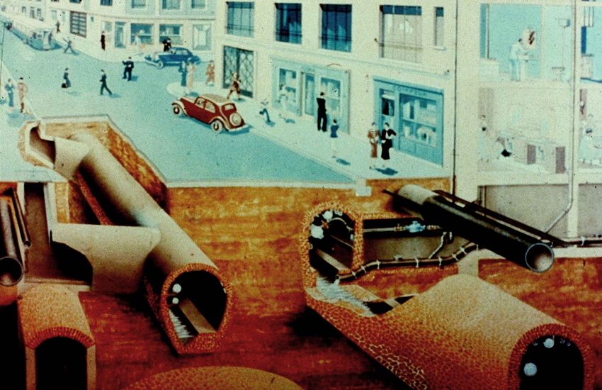
URBAN MOBILITY
l Traditional transport planning aims to improve mobility,
especially for vehicles, and may fail to adequately
consider wider impacts.
l The real purpose of transport is to provide access for the
citizens to work, education, friends and family, and
goods and services.
l A sustainable transport system is one that is accessible,
safe, environmentally-friendly, and affordable.
l Cities should improve the sustainability of their transport
networks to create more vibrant, livable,
sustainable cities.
Why Urban Mobility Matters ?
l Citizens expect high levels of mobility.
l Sustainable urban mobility is essential for:
– Guaranteeing citizens a high quality of
accessibility and life
– Facilitating economic development of cities,
thus helping growth and employment
– Respecting the environment and ensuring
sustainable development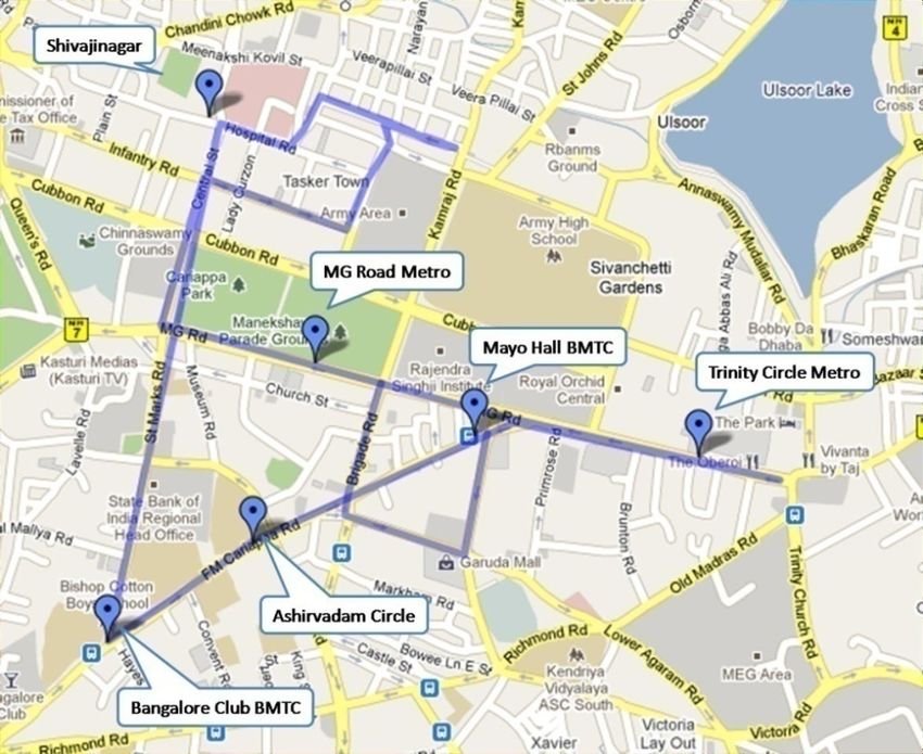
Congestion and Motorization – Sao Paulo, Brazil
Bangalore, India
Seoul city invested in public transportation,
                                including creating bus-only lanes and
                                pedestrian bridges, reforming parking
                                policies, etc. Dr. Lee, Seoul embraced a
 Where’s this?                  “paradigm shift… from car to human-
                                oriented street.”

                                                      NOW
       EARLIER

Seoul, South Korea the Cheonggye Cheong Expressway
- Centre of the CBD carrying 168,000 cars a day
-Replaced by public park and one way streets on either side and a BRT
(Improved bus service)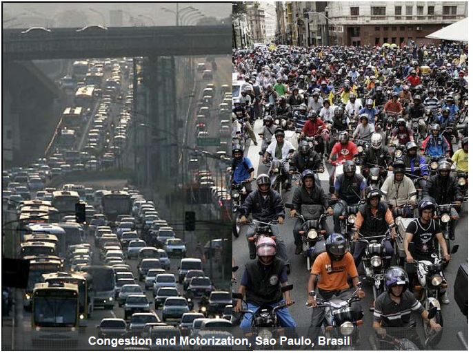
Sao paulo
Growth of the Urban Population
l The United Nations projected that more than half of
the world's population would live in urban areas at
the end of 2015
l Urbanization will be mainly in less developed regions of
the world; Very slow in the more developed regions
l With an estimated population of 1.2 billion, India’s urban
population is growing at >30%
More Mega Cities
MegaCities Mean Huge Infrastructure and transport problems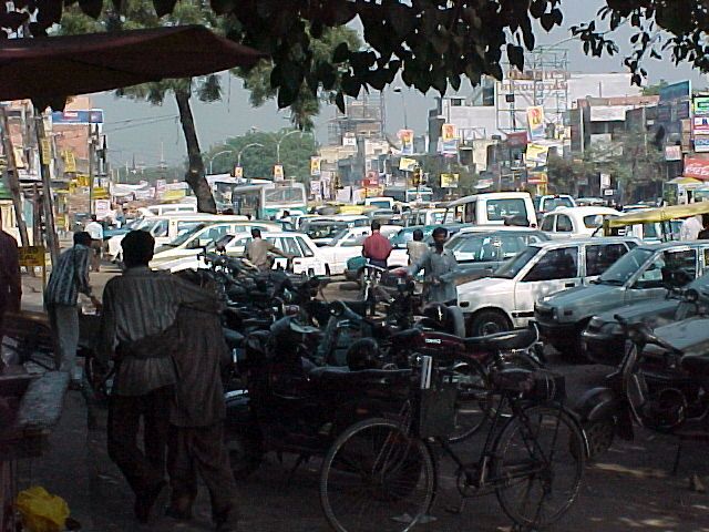
1955

                           1995

2005                       2015

GROWTH OF URBAN REGIONS IN THE LAST HALF CENTURY
This map shows the geographic distribution of cities. It clearly shows that cities are
concentrated in Europe, the eastern United States,Japan, China and India. It is a
better map for showing the geography of night time electricity consumption for
outdoor lighting than it is for showing the geography of population. For example:
the eastern United States is very bright but the more densely populated areas of
China and India are not nearly as bright in this image. NASA Image.
How many cities in India? The big picture
ü About a quarter of India's population is urban
ü Atleast 53 Indian cities have over million residents.
ü 3 cities have > 10 million residents
ü 5 more cities are becoming Mega cities
ü 497 cities with > 100000 population
2011 Census data
Mega Cities Mean Huge Infrastructure and
transport problems
Density of population – Mumbai, Kolkata, Chennai, Delhi, Bangalore ,
Hyderabad – higher density - 10000 people per sq km
Mass rapid transit system is very essential 10INDIA – AUTOMOTIVE INDUSTRY
l Motor vehicles: 12 motor vehicles per 100 persons.
l In Automotive industry, India is one of the largest in the
world and one of the fastest growing globally– Sale of cars
25 to 30% increasing every year
l India manufactures over 11 million 2 and 4-wheeled
vehicles and exports about 1.5 million every year.
l Tata Motors began selling its cheapest car "one-lakh car" in
March, 2009– will increase the car ownership- thought the
Nano would expand the nation's car market by 65%
l In 2009, more than 2.6 million cars were sold in India (an
increase of 26%),
Number of cars sold : 2300s t (1975) Price of Petrol: Rs 3.39 per liter (1975)
26,00,000 (2010) Rs 65 per liter (2011)
Number of car models: 3 (1975) 50+ (in 2011)
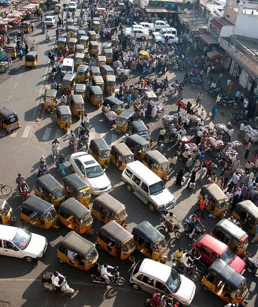
11CHALLENGES FACED BY CITIES
l Congestion
– Increase of traffic in urban areas is causing congestion - this costs
to citizens and businesses
– Parking – Major problem – Portion of road is occupied by Parking
l Energy consumption
– Urban mobility - faced by the domination of oil as a transport fuel.
l Climate change
– Urban mobility accounts for 40% of all CO2 emissions of road
transport.
l Health issues
– towns and cities face increasing air pollution and noise problems,
which impact on citizens health.
l Safety and security
– road fatalities take place in urban areas - pedestrians and cyclists
are the most vulnerable victims.Impact of Global Economic Change
Urbanization, More cars & other vehicles, pollution, congestion, infrastructure development
13Problems of Transport Road Congestion parking Accidents Increasing Traffic intensity
Other Urban Issues
                                       Water

                  Urban Sprawl

Urban Flooding

 Air Pollution

                          Garbage Disposal
Total Emission Load Tonnes Per Day
(source apportionment study for Bangalore, 2007)
PM10 NOx SO2
Transport 22.4 146.36 2.31
Road
Dust 10.9 0 0
Domestic 1.8 2.73 0.68
DG
Set 3.6 50.96 3.35
Industry 7.8 17.19 8.21
Hotel 0.1 0.2 0.02
Construction 7.7 0 0
Total 54.4 217.4 14.6MEGACITIES
1. POPULATION INCREASE
2. GROWTH
3. TRAFFIC DEMAND
4. POLLUTION
RISING COMFORT
Cities are locations having a high level Urban Mobility and its Evolution
of accumulation and concentration of • Collective Transportation (public transit)
economic activities and are complex • Individual Transportation
• Freight Transportation.
spatial structures that are supported by
transport systems.
Urban mobility accounts for 40% of all CO2
emissions of road transport and up to 70% of
other pollutants from transport.Framework for Achieving
Sustainable Urban Transport
l Planning l Analyses
– Vision for a livable city and city – Political
master plan
– Economic
l Land use planning
– Social
l Transport master plan
– Technical
l Design Integrated – Environmental
Transport Systems l Implementation and
– Public transport – commuter rail,
metro rail, mono rail, commuter Monitoring
rail, city buses, taxis, autos – Technical support
– Intermodal Transportation Hubs to – Stakeholder involvement
connect different modes – Institutional setup
– Promotion of Walking and cycling – Capacity
– Private vehicles – Policies
– Trucks and freight movement – FinancingUrban Mobility in India - Needs
l Increase average speed of public transport buses – Bus priority
Lanes, Direction oriented services and BRT systems
l Transit planning / transportation hubs
l NMT policy and cycling routes (intermodal connectivity)
l Additional parking and development of parking policy
l Use of railways to move large section of urban population – Metro
rail, mono rail and commuter rail services to suburban areas
l Use of ITS to optimize the services and occupancy of vehicles
l Strategies to handle Traffic chaos of heterogeneous mix of bullock
carts to Volvo buses
l Need for integrated study for cityʼs traffic and transportation
needs - Creation of Traffic Engineering Cell to collect necessary
data
l Increase awareness about Safety on roads to common public
l Improvement of side walks - Integrating Hawkers and Vendors
who have occupied the side walks
l Trees on Roads / pavements –for better visibility and mobility ??
l Driver education, safety and awareness programmes
19Build
Ensure
capacity to
coordinated
plan for
planning for
sustainable
Projects to urban
urban Ensure
demonstrate transport
transport integrated
best
practices in land use &
sustainable transport
transport planning
Promote ITS,
cleaner fuel &
National Urban People
Transport
focused &
vehicle
equitable
technologies
allocation of
for cities
Policy - 2006 road space
Innovative Investments
financing in public
methods to Establish transport &
Strategies for Non
raise Regulatory parking Motorized
resources mechanisms space and modes
for a level freight traffic
playing field movements
Ref: MOUD, Govt of India presentationNEW CULTURE FOR URBAN MOBILITY
l SMARTER URBAN TRANSPORT l SAFETY AND SECURITY IN URBAN
– Cyber communication, computation and sensing
TRANSPORT
– Use of Cyber physical Systems in urban
– Safer behaviour, infrastructures and
transportation system vehicles
l Vehicles embeds electronic components and control systems – Cross-border enforcement of traffic
to improve performance and safety - vehicle centric sanctions
– High quality information with space and time
– Facing security as a growing threat
along with scenario simulations for better mobility
– Intelligent transport systems and traffic
management l GREENER TOWNS AND CITIES
– Smart charging/ fare collection – New technologies to increase energy
efficiency - increased use of
l ACCESSIBLE URBAN TRANSPORT alternative fuels
– Collective transport accessible and affordable for – Green procurement
all citizens – Traffic restrictions and green zones
– Interconnection of urban and sub-urban networks – Eco-driving
– Co-modality: optimization and integration of
transport modes
l A NEW CULTURE FOR URBAN
l Better organized freight transport MOBILITY
– ITS Supported by larger sensor
l SHARED CARS / NMT POLICIES networks for sensing, cyber
– Shared taxis/autos communication data, and information,
– Optimization of the use of private cars – car computation and simulation models
sharing/car pools for achieving better urban mobility
– Promotion of walking and cycling – Change of behaviour by Education,
training and awareness raisingThe Relationship between the Urbanization
and its Underground Space
Immediate underground level or sub-surface
EVERYTHING IS JUST BELOW THE ROAD !!
REF: International Tunnelling Association - Association Internationale des Travaux en SouterrainThe Relationship between the Urbanisation
(city) and its Underground Space
Deep level or undergroundBenefits of Underground
Ø Land use and location problems
Ø Isolation
Ø Safety – Earthquakes
Ø Environmental preservation
The Underground is Ideal for:
Ø Improving the environment
Ø Supporting Sustainable development
Develop Underground Space in Urban
areas
TO PROTECT THE ENVIRONMENT
We need move from Urban Underground Space Use towards
Urban Underground Space DevelopmentThe elevated highway structure will soon be replaced by approximately 30 acres of
open space along the Artery corridor. Three quarters of the new corridor space will
be designated as open space, with the rest planned for modest buildings. 250
acres in all will be reserved for parks and open space throughout the project area.
Move your mouse over the above image to see the before and after effect. Click
also to see the corridor master plan page.The « Central Artery » - Boston - USA
Underground Construction
            in Urban Areas - Bangalore

Every ring drilled in the Metro tunnel 60 feet below KG -
                      TOI –Jan 22, 12
Rapid urbanisation – Bangalore Case Study
9 million already
live in the city.
An additional
200,000 people
move into the
metropolitan
area each year.Population will grow rapidly
• Within city population will remain stable.
• Growth mainly in the outskirts.
Source: Wilbur SmithBangalore: Development of Vehicular Population
• Rapid growth of motorized vehicles.
• Increasing share of mot. vehicles
• Drastic extension of jams will be the
result.
Source: Wilbur SmithTRAVEL CHARACTERISTICS OF COMMUTERS USING
2-WHEELERS
l NEED FOR STUDY ¨ OBJECTIVE
One of the main observations from ¤ To understand the travel patterns of 2-
vehicular growth trends in Bangalore is wheeler users, their reasons for not
the tremendous use of 2-wheelers. using public transport and evaluate their
Between 2005-2008 nearly 7.5 lakh new willingness to shift towards public
2-wheelers were added. As per vehicle transport under pre-conditions
registration figures (2008), 2-wheelers Study Area
account for 71% of the share. Source: Bangalore Master Plan
¨ METHODOLOGY
Disadvantages of 2- User Advantages
wheeler Growth ¤ Over 1000 surveys
completed in
Prone To More Personal Freedom &
Accidents Flexibility different study
Higher GHG Door-to-Door
zones
Emissions & Pollution Connectivity
Traffic Congestion Lesser Travel Time Study area is divided into 23 zones
Random sampling method adopted
Irregular Traffic & Economical for Short - from each zone the minimum samples about 50
Parking Problems Distances
Data collection - COMPLETED
Comfort Analysis - UNDER PROGRESS
CiSTUP team: MANJULA ; assisted by Ashrita, Shruti ; Guided By: Prof. RamanayyaActual Average Fuel Consumption (TW, Cars)
Mode Total km/Liter Fuel
consumption
l/100km
Scooters 35% 35 2,9
Motor Cycles 40% 50 2,0
Mopeds 35% 60 1,7
Cars Total km/ Petrol Diesel Fuel
Liter consumptio
n l/100km
Small 55% 16 35% 20% 6.3
Cars
Big Cars 30% 10 20% 10% 10.0
Others 15% 8 5% 10% 12.5
• Fuel consumption of TW is low: If change to car will happen, fuel consumption
will increase.
• Fuel consumption for cars and trucks is higher as in Europe due to less Source: CiSTUP
restrictive regulations. This will lead to problems in the future, for the car owner
as well as for the environment and public budget.Transportation Systems in Bangalore
• Vehicle Population: One of the few public sector undertakings
• 3.89 million as on March 2010 l BMTC : (public transport) which is making profits
. – Buses : 7000 Routes operated : 6000
Total Trip Lengths : 13 Lakh km
– Total Trips : 80,000
– Passengers carried : 4.2 million passengers/day.
– 583 city and 1785 sub urban routes, running 13 lakhs
kilometers and making 76266 trips
l Metro Rail: about 8 km is in operation
– 42 Kms under construction at the cost of Rs 11000
Crores.
– Estimated passengers per day: 16.1 lakh (2021)
l Mono Rail: Feasibility study - 54.2 Kms
l Commuter rail: Under discussion with Indian railways
• Number of Auto rickshawʼs - about 100,000
• Radio taxis / cabs
• Car Pool / Car Sharing http://www.carpooling.in/city/Bangalore
•(http://www.commuteeasy.com)
•Shared Taxis/ AutosFacilities at BMTCʼs T T M Cs
l Bus terminal
– Bus bays
– Platforms
– Seating & lighting
– Public conveniences
– Information systems
– Safety and security
l Bus maintenance depot
– Maintenance bays,
– washing platform
– Bus parking
– Services and Utilities
– Fuel filling station
– Amenities for crew
l Passenger amenities
– Bangalore One centers
– Other citizen amenity centers
– ATMs
– Daily needs shopping
l Park and Ride facilitiesDirec&on-‐based bus services along with significant fleet expansion
STUDY OF BUS STOPS AND BUS BAYS IN
BANGALORE CITY
l OBJECTIVES
– Where are the bus stops? Routes
1 2 Considered
– What is the present status?
– Integration with para-transit modes
– Appropriateness of location relative to surrounding
uses/activity centers/ junctions
3
– Scientific design
¨ Works & Findings
– 6108 buses, traveling 13,04,000 km
– 5886 schedules, 78616 trips
– 4.2M commuters, 3.5 crore daily revenue 4
– 35 depot, 47 stations
– 583 city routes, 1785 sub-urban routes, over
– > 2300 bus stops, status not known
– Survey of 165 stops carried out, spatially marked,
photographs taken
– Not for physically disabled and for 60+
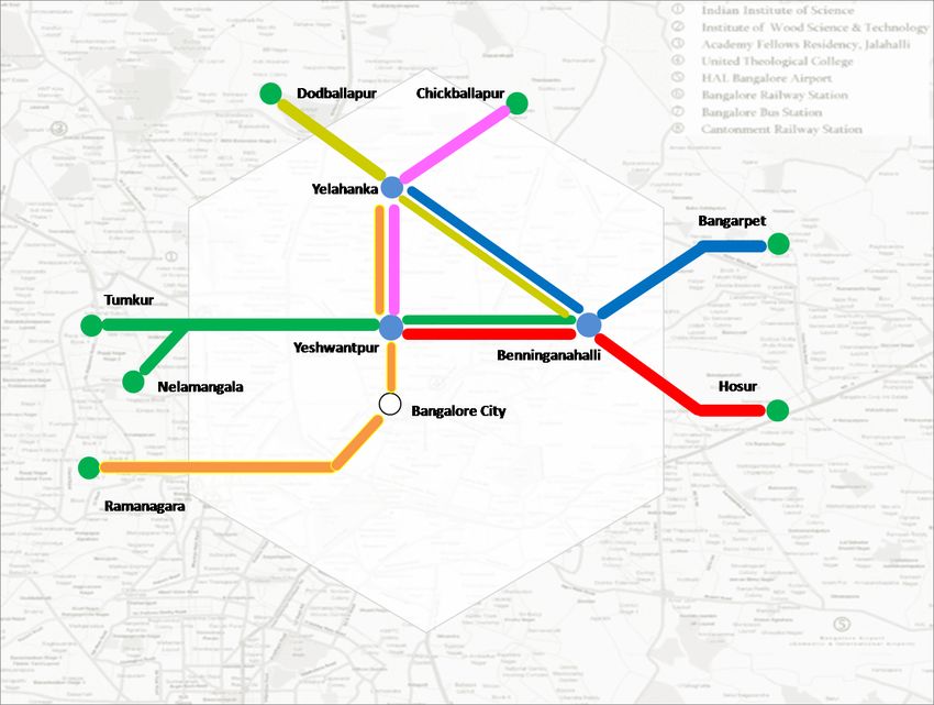
CiSTUP study By: GURURAJA, DEEPAK ; assisted by Dilip, JayAIM TO REPLICATE DELHI METRO
EXPERIENCE ON THE URBAN BUSES
BRT - URBAN BUS TRANSPORT IS IMPORTANT AND HAS
TO BE TRANSFORMED TO A LEVEL THAT IT CAN BE
SOLD TO PUBLIC AS A “BRANDED PRODUCT”
•Hebbal to Bannerghatta Road along eastern crescent of outer ring road (33.0 km)
•Benniganahalli (ORR) to PRR along old Madras Road (7.0 km)
•From ORR to Hosur Rd along Hi-tech Corridor (8.0 km)
•Hosur Road to Tumkur Road along PRR (western part) (41.0 km)
BRTS - With dedicated infrastructure along the route,
specialized vehicles, dedicated road width for Buses – Real
time traffic information to public can be delivered
38 DELHI METRO 38STUDY OF AUTORICKSHAW SERVICE SYSTEM IN
BANGALORE
MULTIPLE STAKEHOLDERS – MULTIPLE
PERSPECTIVES !
l NEED FOR STUDY
PARA-TRANSIT SYSTEMS STATE
GOVT.
Autos and Taxis; Informal Public RTA & RTO
Transport – Matadors, Tempos, etc DIAL TRAFFIC
AUTO POLICE
SERVICES
PRIVATE TRANSPORT
2-wheelers, Cars
PUBLICITY CORPOR
SERVICES -ATION
Growing public frustration regarding the service! PRIVATE AUTO
Integral part of a cityʼs transport system - needs AGENTS & DRIVERS
FINANCIER / UNIONS
to be streamlined and incorporated! S
BANKS & AUTO
FINANCIAL MANUFACTU
SERVICES RERS
¨ OBJECTIVE
To assess the system of autorickshaw services in Bangalore, identify key
areas/ issues for improvement and put forward some suggestions/
recommendations based on it.
CiSTUP study By: FAGUN, RADHA ; assisted by Shreyas, Arjun, Arshita & ShrutiSTUDY OF AUTORICKSHAW SERVICE SYSTEM IN
BANGALORE
¨ Works & Findings ¤ AUTO NUMBERS
Primary Surveys, Interviews and n Registered and Actual Numbers – number of new
consolidation of information autos sold per month in city
from the Literature Review/ n Nature of illegal auto operations
Secondary Data, is in
n Regulations regarding green tax and scrapping old
progress…
vehicles over 15 years old
Presented here is not the final
analysis or conclusions, but ¤ VEHICLE DESIGN & TECHNOLOGY
the consolidated findings of n Regulations regarding vehicle design and
information being collected/ technology, environmental and noise pollution,
collected so far. safety norms, etc.
AUTO NUMBERS (perceptual figures)
Groups Responses Summary/Comments
Auto Drivers n Number varies from 0.8 to 2 lakhs n Responses differ considerably from
nIn their perception about 30-50% autos person to person
are illegal n Many auto drivers think there are
enough or more than required autos in
the city
Manufacturers nAbout 1 lakh autos, of which 20-25,000 nFigures from Transport Dept. GoK Jan
are illegal (25%) 2007 : close to 92,000 autos registered
and kept for use
Easy Auto n About 3 lakh on Bangaloreʼs roads
(!!!)
CiSTUP study by: FAGUN, RADHA ; assisted by Shreyas, Arjun, Arshita & ShrutiIndiaʼs
first
Traffic
Management
Centre
Bangalore Traffic Improvement Project-B-TRAC 2010
B-TRAC 2010: This 5-year programme will cost about Rs. 350 crores. For the financial year 2007-08,
2008-09 and 2009-10, the Government has released Rs. 44 crores, 35 crores and 40 crores respectively. In
the year 2010-11, Rs. 5 crores is planned to be released. The implementation will be done by the Govt.
owned Karnataka Road Development Corporation (KRDCL).Traffic Management
Centre in Bangalore
l Traffic management centre
– 330 signals operational in the city of Bangalore – vehicle actuated signals,
direction boards, pedestrian components, disable friendly auditory signals.
– All of the signals are centrally controlled from traffic management centre (TMC)
with IP based network
– Optimization of timing of signals and pattern
– Surveillance cameras and enforcement cameras
– Real time traffic information to public
– Parking information system
l Traffic helpline
l A High end software application ʻTraffic Silverlightʼ provides
sophisticated GUI for monitoring and managing signals .
l Signal timings can be changed from the Traffic Management Centre
as and when desired.
l Virtual loops with the help of CCTV cameras are
also used for traffic control and monitoring.
l Moving enforcement /SurveillanceEmergency service
• GVK EMRI handles medical, police and
fire emergencies through the " 1-0-8
Emergency service".
• This is a free service delivered through
state- of -art emergency call response
centres and has over 2858 ambulances
• across Andhra Pradesh, Gujarat,
Uttarakhand, Goa, Tamil Nadu, Karnataka,
Assam, Meghalaya, Madhya Pradesh,
Himachal Pradesh and Chhattisgarh.
A system that can allow the clearing of an intersection for
Emergency Vehicles (EVs) to pass and to give right of way
to an EV through an automated system integrating the
Intelligent Transportation System (ITS) with the EV
operations.Bangalore
Transport
Informa&on
System
http:// www.btis.info
TRAFFIC · DIRECTIONS · BUSES · FINES
· RTO · AIRPORT · PUBLIC OFFICES ·
SAFETY · PARKING · TOURISM · METRO
CARPOOL · INDIBUS TRACK YOUR FLEET
Dr. Ashwin Mahesh –
CiSTUP fellowBangalore Metro
l I Phase (2 corridors double lines)
covers ~42.30 km
l N-S corridor will be 24.2 km
l The E-W corridor will be 18.10 km.
l Of the 42.3 km, 8.82 km will be
Underground near City Centre &
Railway Station and the rest will be
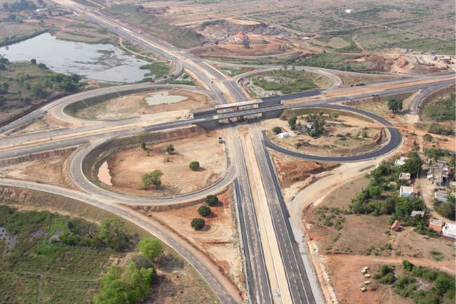
elevatedRoads / Flyovers in Bangalore
The Bangalore Elevated Tollway is a 9.985
Bangalore – Mysore Infrastructure
kilometers (6.204 mi) long elevated, tolled,
Corridor (BMIC) also called NICE road is a 4
access-controlled expressway outside Central
to 6 lane private tolled expressway
Silk Board at the Junction of Hosur Road
with Outer Ring Road
Elevated road to BIA in the making
The Bangalore-Nelamangala expressway
19.5 km stretch, 4.3 km is fourlane elevated highwayMajor road widening project around
Bangalore - executed by the state PWD
with a cost of about Rs 684 crores.
- a total of 39 key roads (884 kms)
were widened.
ROAD NETWORK IN AND AROUND BANGALOREBUS PRIORITY SYSTEM – Pilot Project
Many cities have developed variations
around the general approach of Bus Rapid
Transport (BRT).
The concept of a Bus Priority System
(BPS) is a collection of some (not all) of
the practices from BRT to result in
improved bus services and better
performance.
¨ Objective
¤ A pilot study for BPS on Old Madras Road
CiSTUP study jointly with PRAJANMT PLAN - CBD BICYCLE SHARING SCHEME,
BANGALORE
¨ Project Features:
¤ Creation of the brand for the system
which will lead to uniform expansion
¤ Working out details of cycle and
station design to balance cost,
durability and user friendliness
¤ Determining the operational details,
maintenance and redistribution
processes
¤ Designing, deploying and field-testing
the technology required for system
¤ Rental process - mobile technology
can aid these efforts
CiSTUP study jointly with PRAJANamma Railu – Bangalore Commuter rail system •Branded uniquely identifiable trains & service •Connects major towns approximately an Hours commute away to the nearest hub in the city •Lower frequency than a metro, following a schedule rather then fixed interval and fewer stations spaced further apart •Running speed of Train about 50 Km/h with extra services in the peak hours of morning, evening. •Dedicated EMU Coaches with non-motorized transport friendly features like cycle carriages and low floor for disabled and safety features like closable doors CiSTUP Jointly Praja
An
effort
towards
improved
mobility
in
Bangalore
• Road Design Ducting utilities on 14 arterial roads
• Footpath Budget in BBMP A
dedicated
budget
for
footpaths
• Metro Zone Metro-‐Zone
footpaths
–
30km
this
year
• Commuter Rail - CiSTUP and Praja
• Transport Policy - CiSTUP
• Junction improvements – BBMP and PPP projects
• Non-motorised transport – DULT
• Electric car
18th October 2011 at three locations in the
CBD (Central Business District)
Junc&on
redesign
SOLUTION TO TRAFFIC PROBLEM
l Improved Mobility of 'People' rather than
'Automobiles' should be the principle to
reduce the traffic problem in the city
l “Excellent Public transport is the only the
solution for decongesting the traffic in
cities. Thus the goal shall be to increase
the modal share of public transport
system to 70% or double it by 2020”SUSTAINABLE Urban
Transport
• Walking and biking
• Public transport –
• rail and road based
•Transit oriented development
•Demand management
•Safety
•Environmental friendly –
•alternative fuels,
•hybrid vehicles, etcThank You for your attention !!!
Visit us at: http:/cistup.iisc.ernet.in/You can also read