Reducing Caribbean
 Risk: Opportunities for
Cost-Effective Mangrove
Restoration and Insurance
←
→
Page content transcription
If your browser does not render page correctly, please read the page content below
Reducing Caribbean Risk: Opportunities for Cost-Effective Mangrove Restoration and Insurance
Reducing Caribbean Risk: Opportunities for Cost-Effective
Mangrove Restoration and Insurance
Michael W. Beck1
Nadine Heck1,2
Siddharth Narayan1,2
Pelayo Menéndez1,3
Saul Torres-Ortega3
Iñigo J. Losada3
Mark Way4
Martha Rogers5
Lianna McFarlane-Connelly4
1
Institute of Marine Sciences, University of California, 115 McAllister Way,
Santa Cruz, CA 95060, USA
2
Department of Coastal Studies, East Carolina University, Wanchese, NC 27891
3
Instituto de Hidráulica Ambiental-IH Cantabria, Universidad de Cantabria,
Santander, Cantabria 39011, Spain
4
The Nature Conservancy, 4245 Fairfax Dr #100, Arlington VA 22203
5
The Nature Conservancy, 1101 W River Pkwy #200, Minneapolis, MN 55415
We gratefully acknowledge the funding of AXA Group and the technical
expertise provided by AXA XL for the development and writing of this report.
Photograph on the cover: Tim Calver @ The Nature Conservancy.
Red Mangrove (Rhizophora mangle) grows along the edge of Baie Liberté, Haiti.
Suggested Citation:
Editorial director Beck, M. W., N. Heck, S.
Andrés Barragán Narayan, P. Menéndez, S.
Art director Torres-Ortega, I. J. Losada, M.
Andrés Álvarez Way, M. Rogers, L. McFarla-
Page layout ne-Connelly. 2020. “Reducing
Adriana Villegas Caribbean Risk: Opportunities
Copy editing for Cost-Effective Mangrove
Tiziana Laudato Restoration and Insurance.”
Editorial production The Nature Conservancy,
.Puntoaparte Editores Arlington, VA.
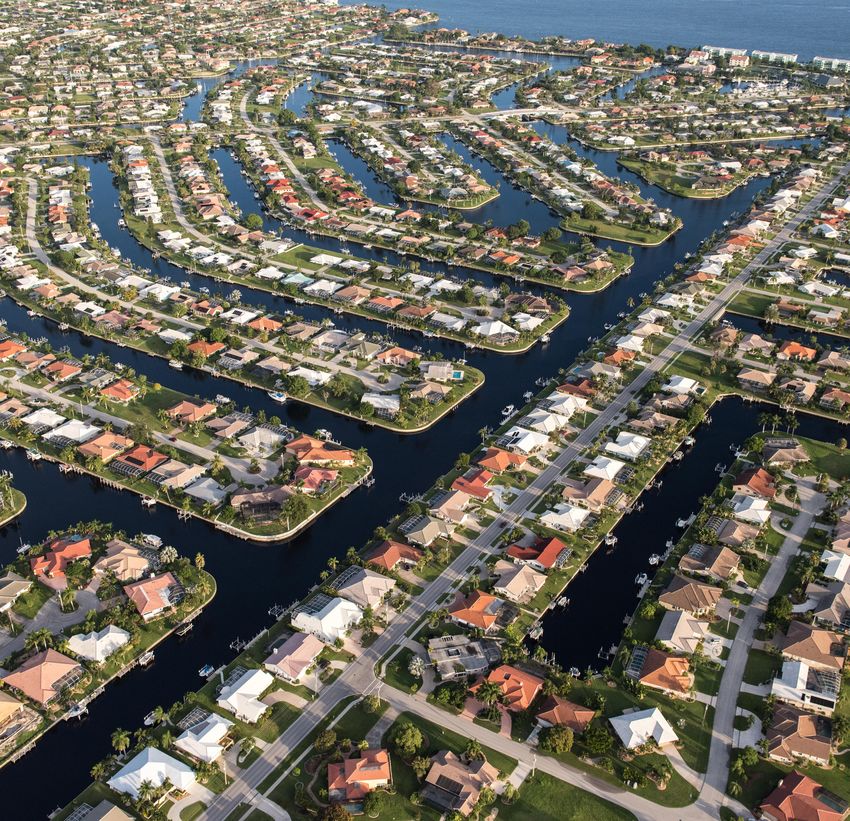
www.puntoaparte.com.co Carlton Ward Jr. @ The Nature Conservancy. Aerial photography of Punta Gorda, on Florida’s
Gulf of Mexico coast at the north end of Charlotte Harbor near the mouth of the Peace River.
ii
Executive Summary
                                                                                                        Mangrove forests play a critically important role in coastal protection. They can dissipate wave
                                                                                                        energy, which can lower flood risk and minimize erosion. Mangrove forests, however, are threa-
                                                                                                        tened by a number of natural and man-made factors, including storm events. Often times,
                                                                                                        mangroves are able to recover post-storm with limited intervention, but active post-storm res-
                                                                                                        toration efforts are required to re-establish mangroves and hasten recovery, particularly when
                                                                                                        hydrological damage has occurred.

                                                                                                        Insurance is a unique market-based mechanism that can cost-effectively protect and restore
                                                                                                        coastal habitat. In Quintana Roo, Mexico, The Nature Conservancy helped launch the first-ever
                                                                                                        insurance product to protect coral reefs from storm damage. We consider whether a simi-
                                                                                                        lar mechanism could be developed for the protection and restoration of mangroves following
                                                                                                        storm events. For example, under a parametric insurance policy, payment would be triggered
                                                                                                        by a natural event and mangroves could be rapidly restored post-storm. Unlike coral reefs,
                                                                                                        however, mangroves do not usually require rapid post-storm interventions in order to survive.
                                                                                                        In this case, an indemnity insurance policy may be created that delivers payments based on
                                                                                                        ex-post assessments of mangrove damage. There are a variety of insurance products available
                                                                                                        that can be tailored to meet the specific needs of mangroves with initial pa-
                                                                                                        youts made quickly through parametric covers and assessed payouts made
                                                                                                        through indemnity cover at a later stage.                                         To measure mangrove
                                                                                                                                                                                          benefits, we estimate
                                                                                                        The market for mangrove insurance products will likely vary based on the
                                                                                                        category of assets most protected by mangroves. In locations where pri-           the economic value of
                                                                                                        vate assets are protected, mangrove insurance could target residential or          mangrove forests for
                                                                                                        commercial customers. In other regions, mangrove forests may protect cri-
                                                                                                        tical public infrastructure, making a mangrove insurance policy targeting
                                                                                                                                                                                           flood risk reduction.
                                                                                                        public entities a feasible alternative.

                                                                                                        Across the Caribbean, we have quantified the cost effectiveness of mangroves for flood risk re-
                                                                                                        duction. To measure mangrove benefits, we estimate the economic value of mangrove forests
                                                                                                        for flood risk reduction in 20 km study units. These results are based on industry-standard
                                                                                                        approaches using probabilistic and process-based valuations of flood risk and the damages
                                                                                                        averted by mangroves. We estimate damages averted by mangroves for four storm frequen-
                                                                                                        cy events - 1 in 10, 25, 50, and 100-year storm events. We combine these modeled mangro-
                                                                                                        ve forest benefits for coastal protection with mangrove restoration costs—estimated to be
                                                                                                        $45,000/hectare in Florida and $23,000/hectare in the rest of the Caribbean—to develop
                                                                                                        spatially explicit benefit-cost ratios.

     Tim Calver @ The Nature Conservancy. A Black Mangrove seedling pushes up through the mud, Haiti.
iv                                                                                                                                                                                             Reducing Caribbean Risk with Mangroves   v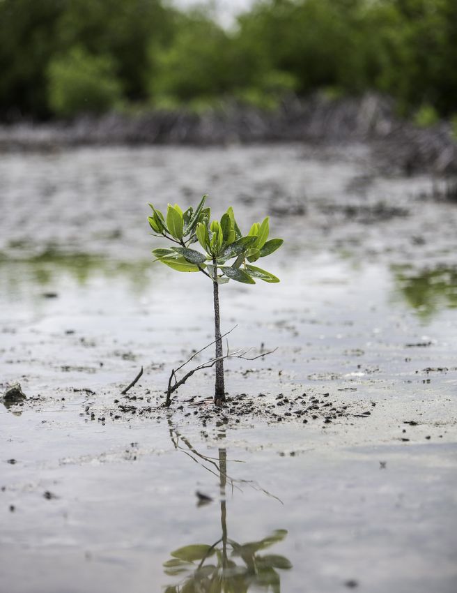
We find that there are 20 states, territories and countries in the Caribbean that have sections
                 of coastline (i.e., ~20 km coastal study units) with cost effective opportunities for mangrove
                 restoration. In total, we identified more than 3,000 km of coastline that have cost effective
                 opportunities for mangrove restoration, with Cuba, the Bahamas, and Florida having the most
                 study units with cost effective opportunities for mangrove restoration. In this study, restoration
                 includes the management, recovery or replanting of damaged or degraded mangroves in exis-
                 ting stands (i.e., where mangroves have or do occur naturally).

                 For seven of the countries that had the largest amount of mangrove coastline which would
                 be cost-effective to restore, we then looked in greater detail at the governance and market
                 characteristics that would most enable the development of a mangrove insurance product.
                 These countries were: the Bahamas, Belize, Cuba, the Dominican Republic, Jamaica, Mexico,
                                     and the United States (e.g., Florida). We show that while the Bahamas
                                     and the United States have the most robust insurance markets, mangrove
             There are               forests in the Dominican Republic and Jamaica potentially protect the
     20 states, territories          largest number of people due to their high population densities.

      and countries in the           The findings here provide a positive perspective as to the feasibility of de-
       Caribbean that have           veloping and deploying a mangrove insurance product in the Caribbean

       sections of coastline         region. These results, however, are only preliminary. Prior to the develo-
                                     pment and deployment of a mangrove insurance policy, a full feasibility
        with cost effective          study would need to be conducted. This full feasibility study should include
         opportunities for           higher-resolution flood-risk models, estimation of the wind reduction be-
                                     nefits of mangroves, and the construction of fragility curves to show the
      mangrove restoration.          relationship between damage to a mangrove forest and some component
                                     of a storm event, such as storm surge or wind speed.

                                                                                                                      Tim Calver @ The Nature Conservancy. Red Mangrove (Rhizophora mangle) grows along the edge of Baie Liberte, Haiti.
vi                                                                                                                                                                                            Reducing Caribbean Risk with Mangroves       vii
Table
       of Contents

        01.                 02.                      03.                     04.                   05.                      06.
       Introduction       Mangrove Risk,        Benefit-Cost Analysis     Insurance Product     Implications and           References
                          Restoration and        of Mangroves in the           Analysis        Recommendations
                      Insurance Opportunities        Caribbean

        Pg. 1-4       Pg. 5-15                  Pg. 16-40               Pg. 41-48             Pg. 49-52                Pg. 53-55
viii                                                                                                               Reducing Caribbean Risk with Mangroves   ix
Introduction

                             Mangrove forests currently cover approximately 14 million hectares across 118 countries (Giri,
                             2010). This expanse of mangrove forests, however, is drastically smaller than what it once was;
                             between 1980 and 2005 about 20% of mangrove forests were lost globally (Spalding et al., 2010,
                             Giri, 2010) and the overall historical loss is probably 50% or more. Fortunately, the rate of man-
                             grove loss has slowed substantially in the last two decades, but mangrove forests continue to
                             be lost each year (Sanderman, 2018). Finding ways to slow or reverse this loss is critical becau-
                             se mangrove forests provide a suite of important ecosystem services (Barbier, 2011). Mangrove
                             forests enhance fish abundance in nearby coral reefs (Mumby, 2004; Serafy, 2015), and they
                             sequester and store a disproportionate amount of carbon relative to their landcover (Hutchi-
                             son, 2014). They play a particularly important role in flood risk and erosion reduction by slowing
                             storm surge and dissipating wave energy (World Bank, 2016; Menéndez et al. 2020), which is
                             especially important in terms of risk reduction and insurance considerations.

                             There are critical opportunities to harness the power of wetlands and reefs to reduce the im-
                             pacts of storms and other natural hazards (Narayan et al., 2016; Narayan et al., 2017; Beck et al.,
                             2017; Beck et al., 2018a,b; Beck et al., 2019a,b, Reguero et al., 2018; Menéndez et al., 2020). The
                                                  good news is that we can restore mangroves, if we identify the resources
                                                  with which to do so.
         The good news is
       that we can restore                      This report assesses the potential of mangroves as cost-effective risk re-
                                                duction mechanisms and identifies where insurance could be used to help
         mangroves, if we                       guarantee the continuation of this benefit for communities and countries ali-
       identify the resources                   ke. First, we provide an overview of habitat insurance and the risk reduction
                                                benefits of mangroves. Then, we make a spatially explicit benefit-cost analy-
        with which to do so.                    sis for mangrove restoration across the entire Caribbean to identify where
                                                there may be cost effective opportunities for insurance and investment in
                             mangroves. Lastly, we provide a high-level market analysis of opportunities in the Caribbean
                             for mangrove insurance based on these benefit-cost analyses and our experience with the reef
                             insurance model.

                             Insuring natural assets is a novel and innovative concept. The Nature Conservancy and the
                             Government of Quintana Roo, Mexico launched an insurance product for coral reefs and bea-
                             ches in 2019. Using the context of coral reefs, we can illustrate how such an insurance product
                             could be used to protect and restore mangrove forests and other natural storm defenses such
                             as coastal marshes.                                                                                   Tim Calver @ The Nature Conservancy. A Conservation Planner from the Nature Conservancy
                                                                                                                                         Grenada office stands with young red mangrove seedlings which are part of the At the
                                                                                                                                       Water’s Edge Mangrove restoration project on Telescope Beach near Grenville, Grenada.
1   Reducing Caribbean Risk with Mangroves                                                                                                                                                                                      2
Hotels pay to municialities
The concept of the coral reef insurance product is relatively straight forward. Coral reefs redu-
ce 97% of wave energy (Ferrario et al., 2014) and significantly reduce property damage during
storms (Beck et al., 2018a). Protecting coral reefs is an effective means of reducing the risks
people and properties are subject to because of storms, and we have found that coral reef insu- 1. Municipalities etc.
rance can be an effective protection mechanism to preserve risk reduction and other benefits pay into trust fund.
provided by the reefs. Insurance can be used to guarantee funding to repair coral reefs after a
major storm, much like other artificial infrastructure, to restore and preserve these protection
benefits for future events.
Catastrophe
The insurance product set up by TNC and partners in Quintana Roo, Mexico, was designed insurance
around this logic. The team established a parametric insurance product to help maintain coral
reefs and beaches along over 160 km of the coast. The insurance is triggered if wind speeds in
Trust Fund
a designated area are recorded in excess of 100 knots. The maximum payout over the 12-mon-
th period, or the Annual Aggregate Limit, was $3.8 million (USD).1 The ultimate payout of the 3. Trust fund
insurance product is based on the maximum recorded wind speed during a storm event: (i)
purchases parametric
a payout equal to 40% of the maximum payout (~$1.5 million) if wind speeds are between
catastrophe insurance.
100 and 130 knots; (ii) a payout equal to 80% of the maximum payout (~$3.0 million) if wind
speeds are between 130 and 160 knots; and (iii) a payout equal to 100% of the maximum pa-
yout (~$3.8 million) if wind speeds are in excess of 160 knots. 2. Trust fund contracts services
for reef restoration, maintenance 4. Event triggers parametric
The implementation of the coral reef insurance product in Quintana Roo, and resilience needs. insurance payout which is
Coral reefs reduce Mexico follows a trust fund mechanism (see Figure 1) which is designed paid into the trust fund for
97% of wave energy to collect and disburse funds for coastal management. In this case, the
trust fund purchases the insurance product. The trust fund then acts as the
immediate reef repair work.
and significantly reduce single purchaser of the insurance product. The trust is designed to be able
property damage to accept funds from public, private and philanthropic sources as well as a
federal fee collected from beachfront property owners who wish to use the
during storms. beach for commercial purposes. Property owners and coastal communities
benefit from the coastal protection provided by the coral reefs and from
the fact that having coral reefs situated right off their shorelines attracts many tourists. The
municipalities collect the federal fee from property owners that benefit from the coral reef’s
protective capacity and transfer it to the trust fund.2 This also helps to ensure that there are no 5. Hotels and communities
free riders. 6. Livelihoods and benefit from the payout as
tourism assets are resilience value of reef is
To expand the reef insurance example and assess opportunities for a mangrove insurance pro-
protected. restored and from beach
duct, we address two key components in this pre-feasibility assessment. We consider where
mangroves and mangrove restoration can offer cost-effective benefits for risk reduction and
cleanup/restoration.
where there are likely to be suitable insurance market conditions.
Figure 1
1.
The description of the Quintana Roo coral reef insurance policy relates to the inaugural policy which began on June 1, 2019. Trust Fund and Insurance Mechanism.
2.
At the time of writing, funding is provided by the State Government of Quintana Roo. Adapted from T. Zoltani, 2017
3 Reducing Caribbean Risk with Mangroves 4Mangrove Risk,
Tim Calver @ The Nature Conservancy. A dead mangrove forest resulting from
being cut off from water circulation by a road and railroad, Salt River, Jamaica.
Restoration
and Insurance
Opportunities
Risks to Mangroves
Mangrove degradation can result from several naturally occurring events. Changes in precipitation patterns will impact the extent and health of mangroves, which, in ge-
Mangroves are Strong storms, such as hurricanes, can impact mangrove forests by da- neral, tend to migrate inland during periods of high rainfall and to contract seaward during pe-
maging, or killing, mangrove trees. Mangrove damage from hurricanes in riods of low rainfall (Lovelock et al., 2017; Ward, 2016). A decline in precipitation, for example,
threatened by a number the Caribbean has been shown to be primarily a function of wind speed; could limit a mangrove forest’s ability to naturally migrate and respond to sea level rise (Ward,
of different factors, both the relationship is sigmoidal with some evidence of damages around 100 2016). One of the worst mangrove die offs recorded was in Australia’s Gulf of Carpentaria in
km/hour and much higher rates of loss at wind speeds of 130 km per hour the summer of 2015-2016. During the event, below-average rainfalls, high temperatures and
natural and man-made. (approximately 70 knots) and above (Imbert, 2018). Besides wind speed, low sea levels combined to result in the dieback of mangroves along 1,000 kilometers of coast-
several other aspects affect damage rates including distance of the man- line (Duke et al., 2017). Mangrove diebacks have also been shown to follow El Niño events in
grove forest from the center of the storm, orientation of the mangrove forest with respect to Australia when sea levels can be 20-30 centimeters lower (Lovelock et al., 2017).
the storm, and mangrove species with red mangroves being more susceptible to storm da-
mage than black mangroves (Imbert, 2018). In addition, strong wave surges associated with Finally, mangroves are also predicted to expand their ranges as average temperatures rise.
storms can have devastating impacts for mangrove forests particularly to forests on exposed Mangrove extent is generally limited by, among other things, the frequency of extreme cold
windward coasts (Cahoon and Hensel, 2002). events, defined as days cooler than -4°C (25°F). On the east coast of Florida, the area of
mangrove forests has doubled at the northern end of their range over the last 28 years as the
There are many additional factors—outside of just storm events—that affect mangrove growth frequency of extreme cold events has decreased (Cavanaugh et al., 2014).
and recovery trajectories. Sea level change will have a varying, but often negative, effect on
mangroves. Mangroves have the potential to accumulate sediments and grow land vertically Mangrove forests are threatened by various man-made impacts. For example, the growth of
and thus keep up with moderate sea level rise. In this regard, mangroves are likely more resi- shrimp aquaculture, coastal development, timber harvesting, and pollution runoff have all been
lient to sea level rise than marshes (which can also raise sediments and create land, but not linked to mangrove forest degradation or destruction. (World Bank, 2019). Altered landscapes
as quickly). However, sea level rise will also ‘push’ mangroves landward and losses will occur can also affect ecosystem characteristics, such as tidal flows, in a way that is detrimental to
more often due to coastal squeeze, where mangroves may have the necessary conditions to mangrove health (Lewis, 2016).
move inward to avoid sea level rise but there is no suitable space for them to go (due to either
man-made or natural barriers) (Alongi, 2015).
5 Reducing Caribbean Risk with Mangroves 6Mangrove Restoration Mangrove restoration for risk reduction is likely to include innovative approaches to ensure
and speed up the delivery of flood and erosion risk reduction benefits. These approaches could
include planting more mature trees in the front line to break waves and slow erosion, thus offe-
ring immediate protective benefits to people and enhancing successful seedling growth behind
the front line. A number of mangrove restoration projects combine grey or hybrid infrastruc-
Mangroves are able to recover post-storm with minimal or no intervention as long as the ture, such as reed fences or cement planters, to promote mangrove growth; reed fences can
elevation and hydrology have not been deeply affected (for example by sediment loss). In slow initial erosion which would impede mangrove growth and cement planters can improve
many respects, mangroves act like weed species and can grow quickly in an intertidal en- the establishment of mangrove trees on the front-line.
vironment with few competitors. Overall, their natural recovery is often faster than for any
other marine ecosystem. Initial recovery can be seen in 3-5 years when new generations of Restoration efforts should incorporate support for the ongoing management of mangrove fo-
mangroves are able to take hold, but full recovery of an ecologically functioning forest can rests. For example, regular maintenance of roads, such as clearing broken branches, can help
take time (Imbert, 2018). However, mangrove recovery could face several different hurdles. maintain hydrological flows that are important for mangrove health. Ultimately, the ongoing
Strong winds and waves can combine for significant erosion that reduces elevation below management of a mangrove forest will decrease its likelihood of sustaining extensive damage
the tidal threshold for propagule (seed) establishment (Asbridge, 2018). Mangrove forests in the event of a storm.
can be suffocated by excessive sediment deposits if the storm brings the sediment too far
landward (Cahoon, 2002). Finally, any mangrove management project should place some emphasis on greater ecosystem
management and reporting. A joint report published by the International Union for Conserva-
In many circumstances, particularly those where mangroves are situated around human tion of Nature and TNC (McLeod, 2006) listed seven factors for ongoing mangrove manage-
developments, more active restoration efforts are required to re-establish mangroves and ment success, which are shown in Figure 2.
to hasten recovery. An assessment of post-storm status can provide valuable information
on whether or not the impacted area would be suitable for planting or
whether it requires interventions such as hydrological modifications. A
A review of 160 review of 160 documented mangrove restoration efforts across 24 coun-
Access to a healthy supply of
propagules, either internally or Limited anthropogenic stress.
documented tries illustrated a largely positive picture of mangrove restoration success from adjacent mangrove areas.
mangrove restoration (Worthington and Spalding, 2018). For projects that are well-documen-
ted, survival rates range from 60-90% after 10 years (Worthington and Strong mangrove recruitment
efforts across 24 Spalding, 2018). indicated by the presence, variety, Unimpeded or restored
countries illustrated a and abundance of established
mangrove propagules.
hydrological regime.
Some restoration efforts have been less successful. A review of large-sca-
largely positive picture le mangrove restoration efforts in Sri Lanka following the 2004 tsunami Control of common threats such as
of mangrove restoration showed 54% of plantings, and roughly one-third of sites, had no surviving Close proximity and
connectivity to neighboring
dredging and filling, conversion to
aquaculture ponds, construction of
plants after 5 years, one-third of the sites had survival rates under 10%,
success. and the remaining one-third of sites had survival rates of between 10%
stands of healthy mangroves. dams, roads, and dikes that disrupt
the hydrological regime.
and 78% (Kodikara et al., 2017). Common factors that have been identi-
fied in limiting the success of mangrove restoration efforts include placing plants in locations Access to sediment and
not suitable for mangroves due to topography and flooding (Kodikara et al., 2017), planting freshwater.
in areas where mangroves did not previously exist (Lewis, 2005), and a mismatch of species
selection that does not consider the biodiversity needs of the site (Lewis, 2005). While the-
se examples highlight the need to consider ecological factors in mangrove restoration, such
Figure 2
restoration can be successful in cases that incorporate proper planning. For example, of the Identified Factors for Ongoing Mangrove Management Success.
160-plus mangrove restoration projects reviewed by Worthington and Spalding (2018) over Source: McLeod, Elizabeth and Rodney V. Salm. (2006). “Managing Mangroves for Resilience to Climate Change,” IUCN,
80 of them were deemed successful. Gland, Switzerland: pp. 64.
7 Reducing Caribbean Risk with Mangroves 8Opportunities for a
Mangrove Insurance Product In the case of parametric insurance, an important decision-point is the triggering event. In the
case of the coral reef insurance product in Mexico, the trigger point was recorded wind speed
in a given area; payouts started when wind speeds of 100 knots or more were recorded and
Given that mangrove forests create significant protective value for coastal communities, there maxed out when wind speeds of 160 knots—equal to a category five hurricane—or more were
is likely an opportunity to insure these natural assets, as in the case of coral reefs. Initially, we recorded. When insuring mangrove forests using a parametric insurance product, it would be
focus on opportunities to insure mangrove forests from damage incurred during storm events. important to decide what the appropriate trigger point for payouts would be, with wind speed
Assessing the potential for a mangrove insurance product covering storm events is logical gi- being the most likely trigger point.
ven that it is more straightforward to assess the fragility of mangroves to wind speed or storm
surge—common characteristics of a storm event—than other more nuanced ecological stres- In deciding on the triggering event and trigger point for a mangrove insurance project, careful
sors, such as precipitation and sea level rise. At the end of this section, we highlight potential thought will also need to be given to the associated basis risk (defined as the imperfect co-
opportunities for a mangrove insurance product outside of storm events. rrelation between index and individual loss). In designing a parametric insurance product, the
triggering event, index, and trigger point must reflect the insured risk as accurately as possible.
Identifying the Appropriate Insurance Product Basis risk refers to the degree to which the insurance index under or overestimates the damage
following a triggering event. In the case of a mangrove insurance product,
A key decision when setting up a mangrove insurance product is what type of insurance pro- basis risk would occur, for example, if a triggering event that was linked
duct to use. For the coral reef insurance product discussed above, a parametric insurance pro- to wind speed did not match up closely with the expected damage sus-
Ideally, historical storm
duct was implemented where insurance payouts were made based on the recorded wind in- tained to a mangrove forest during a storm event. For one, a mangrove events serve as the
tensity of a storm. In the case of mangroves, as with coral reefs, there are key characteristics forest may be in the lee of a storm and even though the wind speeds
ground for assessing the
of parametric insurance that make it likely to be the best candidate for an insurance product. exceed the trigger point the mangroves sustain limited to no damage.
Conversely, a mangrove forest could sustain damage even if a storm’s historical damages and
Parametric insurance payouts can be made in as little as 10 working days of the damage oc- wind speeds do not exceed the trigger point. Thus, when deciding on the losses which allows for
curring. This fast payout schedule is because parametric insurance, unlike traditional property appropriate triggering event and trigger point for a mangrove insurance
indemnity insurance, is not tied to a specific asset but rather to a specific triggering event. As product, careful thought needs to be given to factors that affect mangro- an accurate structuring
soon as the triggering event occurs, the pre-defined payout can be made to the insured party. ve forests, how their impacts on mangrove forests can be measured, and of the trigger point and
With parametric insurance, there is no need to wait for an insurance assessor to come to the the vulnerability of mangrove forests to those factors. Ideally, historical
property and assess the amount of damages incurred and what will and will not be covered by storm events serve as the ground for assessing the historical damages
mitigates the challenge
insurance. This quick payout could be beneficial where a rapid post-disaster response to man- and losses which allows for an accurate structuring of the trigger point with basis risk.
grove restoration may be necessary to ensure the long-term viability of the mangrove forest. In and mitigates the challenge with basis risk.
many cases, rapid restoration action may be less critical for mangroves per se than it is for co-
ral reefs. However, rapid payouts that help provide restoration jobs in local communities could Mangrove forests could also potentially be insured following a more traditional property in-
be socially beneficial, which could have indirect and long-term benefits for ecological recovery. demnity insurance model. In contrast to parametric insurance, with property-indemnity insu-
rance, the size of the payout would be based on ex-post assessments of mangrove damage. In
A parametric insurance policy would cover a defined geographical area, which identifies the man- this example, mangroves could be rolled into corporate insurance where, for example, a com-
groves included in the insurance policy. Estimated restoration costs would form the basis to cal- pany that restores and/or maintains a mangrove forest of a specified size and location could
culate the required amount of insurance coverage. Several recent studies address the relationship then qualify for a reduction in insurance premiums. It is open to question whether it may be
between wind speed and mangrove destruction (Imbert, 2018; Tallie et al., 2020; Tomiczek et al., feasible to develop a similar model with private home insurance, with verification as one of the
2020). Another issue is the likely cost of restoration if there is both mangrove loss and extensive practicalities that would have to be addressed.
hydrological alteration (e.g., extensive erosion or sedimentation). It is likely that restoration costs
may increase non-linearly with wind speed because of these hydrological/topographical impacts.3 Alternatively, a combined parametric-indemnity insurance product could be created. In this case,
a percentage of the payout could be paid out immediately post-storm through the parametric
3.
Non-linearity in restoration costs/efforts was also assumed with coral reef insurance. portion and a remaining portion could be paid out at a later date based on assessed damage.
9 Reducing Caribbean Risk with Mangroves 10Mark Godfrey/TNC @ The Nature Conservancy. Boats used by the local shrimp cooperative of Salto de Agua lay
at rest in the coastal wetlands and mangrove forest of the La Encrucijada Biosphere Reserve of Chiapas, Mexico.
multiple property owners. On the flip side, if all benefiting property owners took out their own
mangrove insurance policies the logistics of aggregating and disbursing payouts for mangrove
restoration could quickly become cumbersome and a hindrance to the post-storm restoration
of the mangrove forest.
Multiple schemes may be used to get around this collective action problem. As in the case of
the coral reef insurance in Mexico, a trust fund could be created. In the Mexico example, all be-
nefiting property owners agreed to pay into the trust fund. Alternatively, a composite insuran-
ce policy could be used (Sanderman, 2018). With composite insurance,
individual property owners are insured under a single insurance policy
where their payments into the policy are a function of the relative pro-
A national or local
tective benefits received from the mangrove forests. Finally, the man- government could opt
grove insurance product could be purchased directly by an insurance to purchase a single
company to cover regions where a portfolio of insured properties has
extensive coastal exposure. mangrove insurance
plan to reduce storm
A mangrove insurance product could also be purchased by the public
sector, such as a national government, which would avoid this collecti-
damage in specified
ve action problem. Mangroves often provide critical coastal defenses to regions with the intent
important public infrastructure. Ports, airports, wastewater treatment
and energy transfer facilities were built in the lowest lying open areas
of protecting many of its
near urban centers, which often meant over mangroves. A national or different stakeholders,
Identifying the Appropriate Insurance Customer local government could opt to purchase a single mangrove insurance
including private citizens
plan to reduce storm damage in specified regions with the intent of
The second decision when setting up mangrove insurance focuses on identifying the primary protecting many of its different stakeholders, including private citizens and companies.
customer. Ultimately, the identified customer will be location-specific and depend on the as- and companies. Due to the protection gap, the costs of storm relief and
sets that are being protected by a specific mangrove forest. In areas where mangrove forests recovery efforts are typically covered by governments. In many cases, maintaining mangrove
protect residential houses, individual private citizens may wish to purchase a mangrove in- forests is a cost-effective means of mitigating storm damage affecting sea walls and other grey
surance product. Similarly, in areas where mangrove forests protect commercial properties infrastructure (Bell and Lovelock, 2013). Consequently, a government could find that purcha-
– such as hotels – private businesses may wish to purchase a mangrove insurance product. sing mangrove insurance is a cost-effective means of ensuring that mangrove forests within a
given area are maintained sufficiently to maximize protection to inland communities from stor-
For both residential and commercial insurance, there are complications that could arise in de- ms. Additionally, mangroves are often on public land and governments may already be commi-
veloping an individual insurance product. In any mangrove insurance product, one needs to un- tting millions of dollars to restoring mangroves. There is the possibility that a publicly-oriented
derstand what area of land is protected for a given parcel of mangrove forests. If a given parcel mangrove insurance product could also be of interest to local or global humanitarian and/or
of mangrove forest protects multiple properties, whether they are residential or commercial, disaster risk-reduction organizations as either a stand-alone product or integrated into other
then any one property holder taking out mangrove insurance will end up inherently benefiting product offerings.
11 Reducing Caribbean Risk with Mangroves 12Opportunities for Mangrove Insurance Beyond Storm Events
Up until now, we have focused on the benefits of insuring mangrove forests in order to pre-
vent or reduce damage to physical assets from a storm event. As discussed above, however,
mangroves are subject to additional ecological stressors outside of storm events. Mangrove
forests also provide many other benefits to neighboring communities beyond property protec-
tion (Barbier, 2011). When considering mangrove insurance, it may be feasible to develop an
insurance product that focuses on one of these other benefits or stressors. One possible alter-
native mangrove forest benefit to consider for an insurance product relates to carbon storage.
Mangrove forests are considered one of the most carbon-dense ecosystems in the world – the
carbon storage benefits of marine habitats, including mangroves, is commonly referred to as blue
carbon. Mangrove forests are able to store carbon not only in their biomass but also in the soil,
acting as long-term carbon sinks, and making them incredibly effective environments for carbon
storage (Sanderman, 2018). The Caribbean is home to mangrove forests that store a significant
amount of carbon and many of these countries have lost soil carbon at notably high rates since
2000 (Sanderman, 2018). Although insurance for carbon credits is fundamentally different from
the mangrove insurance discussed above, it is still possible to develop a mangrove insurance pro-
duct related to carbon storage (Bell and Lovelock, 2013). Insurance Facilitators in Australia, for
example, launched one of the first insurance products to cover sequestered carbon from forests,
which works in collaboration with major accredited carbon offset projects (Insurance Facilita-
tors). A similar product could be developed for mangrove forests. Alternatively, the development
of a mangrove insurance product could potentially be expedited if insurance companies were
able to count the carbon sequestration benefits of insured mangrove forests as carbon offsets.
A mangrove insurance product could also theoretically be linked to non-storm related ecological
stressors, such as precipitation or temperature changes. Assessing the fragility of mangroves
with respect to these stressors, however, is likely to be much more difficult than assessing the
fragility of mangroves with respect to different intensities of storm events. For one, the impact
of precipitation and temperature changes on mangrove forests is much more location-specific
than the impact of storm events on mangroves, with some regions experiencing expansion of
mangrove forests as rain events increase and/or temperatures increase, while other regions ex-
perience the opposite effect. Thus, any insurance product focusing on these ecological stressors
would potentially need to construct dozens of different fragility curves specific to the region and
stressor – an enormously time-intensive pursuit. While feasible, it’s much more likely that any
cost-effective mangrove insurance product would focus on the impact to mangroves from storm
events. Funding from any storm-related insurance product would then have to be utilized effi-
ciently to resolve any other compounding factors that threaten mangroves.
Tim Calver @ The Nature Conservancy. Community planted mangroves grow along the shore in Caracol, Haiti.
13 Reducing Caribbean Risk with Mangroves 14From an economic
Benefit-Cost Analysis
perspective, mangrove
insurance will be feasible of Mangroves in the
Caribbean
in areas where mangrove In order to identify which locations to focus on for mangrove insurance in
forests exist, where the Caribbean, we begin with a high-level country analysis. For any local
mangrove forests provide analysis, we’ll need to consider both supply-side factors and demand-side
factors. Supply-side factors refer to whether insurance providers show inte-
protective, and other rest in developing a product and have the ability to do so. The demand-side Government agencies and the world’s biggest (re-)insurers are considering how their funds could
benefits, and where it factors refer to the process of identifying the recipients of mangrove pro- be invested in habitat restoration to reduce future risk and build resilience. For example, the US
tection, and other services (e.g., residential, commercial, or government), Federal Emergency Management Agency (FEMA) has indicated that they can fund restoration
is cost-effective for the and how much they would be willing to pay to insure the mangrove forest, with storm recovery funding if it can be shown in their benefit-cost analysis that such projects
beneficiaries to restore or which in turn, is a function of the amount of benefits received. From an achieve benefit-cost ratios (B:C) greater than 1. Likewise, the insurance industry and ecologists
economic perspective, mangrove insurance will be feasible in areas where are developing tools to estimate where resilience insurance could be used to pay for restoration
protect the mangrove forests exist, where mangrove forests provide protective, and up front based on reduced risk and premiums later (Reguero et al., 2020). To realize these oppor-
mangrove forest. other benefits, and where it is cost-effective for the beneficiaries to restore tunities, we must provide critical information on mangrove benefits and restoration costs to build
or protect the mangrove forest. the B:C maps that can guide cost effective mangrove conservation and restoration.
Erik Kruthoff @ The Nature Conservancy. Sunset over a saltwater tidal creek and mangrove forest on the island of Eleuthera, the Bahamas.
15 16Methods
We have developed benefit-cost maps based on (i) recently published work that measures the be- flood maps on economic asset information downscaled to 30 x 30 meters and assessed by
nefits of mangroves for flood risk reduction globally (Menéndez et al., 2020), (ii) new data on the flood depth to identify flood damages (risk) and avoided damages (mangrove benefits).
costs of mangrove restoration, and (iii) the assessment of mangroves as a 30-year coastal asset.
The core assessment considers coastal flood risk and the value of mangroves for reducing this risk. The values that we have provided for both mangroves and coral reefs (Beck et al., 2018a; Me-
néndez et al., 2020) are the first global estimates of flood risk reduction benefits provided from
To measure and value the coastal protection benefits provided by mangro- process-based models for any coastal or marine ecosystem. This work represents a state of
The flood protection ves, we follow the Expected Damage Function approach (Figure 3) com- the art in global flood risk and benefits assessment and has been shown to provide better es-
monly used in engineering and insurance sectors and recommended for timates than replacement cost approaches (Barbier et al., 2015; World Bank, 2016). We have
benefits provided by the assessment of coastal protection services from habitats (World Bank, chosen this approach over others because it is (i) quantitative in contrast to other approaches,
mangroves are assessed 2016). The flood protection benefits provided by mangroves are assessed which use indicator (expert) scores to assess shoreline vulnerability (e.g., Silver et al., 2019),
as the flood damages avoided to people and property by keeping mangro- (ii) it uses the methods and tools of risk agencies, insurers, and engineers (Narayan et al.,
as the flood damages ves in place. We couple offshore storm models with coastal process and 2016; Narayan et al., 2017; Reguero et al., 2018), (iii) it is consistent with approaches for natio-
avoided to people and flood models to measure the flooding that occurs with and without man- nal accounting (World Bank, 2016), and (iv) it accurately captures impacts of extreme cyclone
groves under different storm conditions. These flood extents are used to events that are typically underestimated in global studies.
property by keeping estimate the averted flood damages to people and property and hence the
mangroves in place. expected benefits of mangroves in social (people protected) and economic We measure the flood protection benefits of mangroves all over the world for coastal flooding
terms (value of property protected). These methods have been applied in a from extreme water levels at the shoreline. Following this approach, the role of mangroves in
number of prior projects to assess the value of coral reefs for coastal protection globally (Beck coastal protection is examined by measuring the economic impacts of coastal flooding on people
et al., 2018a), and to assess the value of mangroves for coastal protection in the Philippines, and property under two scenarios: with and without mangroves. The “without mangroves” sce-
Jamaica, and globally (Losada et al., 2017; Menéndez et al., 2018; Menéndez et al., 2020; Beck nario assumes complete loss of the habitat and the consequent erosion of
et al., 2019a). the intertidal area into a smooth sandy surface.
Our global study covers
Our estimates are based on a set of global process-based models, applied to the Caribbean Our global study covers 700,000 km of mangrove-inhabited coastli- 700,000 km of
region, that identify the annual expected benefits of mangroves for flood risk reduction (Me- ne that includes more than 141,000 square km of mangroves. The mo-
néndez et al., 2020). We use a set of hydrodynamic and economic models to identify the area dels require a huge amount of data and high computational effort, so mangrove-inhabited
and depth of flooding (i) for mangrove coastlines, (ii) in model runs with and without mangro- a four-level subdivision of the world is made to organize data and mo- coastline that includes
ve, and (iii) for four storm return periods, 1 in 10, 25, 50, 100-year driven by local storm data. deling efforts (see Figure 4). The first level is the division into five ma-
We first develop and validate these models in the Philippines, a country with over 36,000 km cro-regions, corresponding to the five ocean basins of tropical cyclone
more than 141,000
of heavily populated coastlines, at high risk from cyclones, and more than 200,000 hectares generation (Knapp et al., 2010). The second level divides the 700,000 square km of
of coastal mangroves (Menéndez et al., 2018). We use these models to develop a dataset of
several thousand simulations to statistically describe the physical relationships between (i)
km of coastline into 68 sub-regions considering coastline transects of
similar coastal typology (e.g., islands and continental coasts) and similar
mangroves.
tropical cyclones and offshore wave climate; and (ii) offshore wave climate, mangrove para- ecosystem characteristics. The third level of disaggregation involves lo-
meters, and extreme sea level in coast. This dataset is then used to build regression models cal scaling, taking units with 20 km of coastline and extending up to 30 km inland and 10 km
and interpolation tables to estimate how mangroves modify extreme water levels at the shore- seaward, with the aim of providing local results. The fourth, and final, subdivision is the coast-
line. Finally, for every kilometer of mangrove shoreline globally, we overlay the resulting coastal line profiling of every kilometer.
17 Reducing Caribbean Risk with Mangroves 18Offshore Nearshore
Dynamics Dynamics Habitat Impact Consequences
Figure 3
Key Steps and Data for Estimating the Flood
Protection Benefits Provided by Mangroves.
Step 1. Offshore dynamics: Ocea-
nographic data are combined to
assess offshore sea states.
Step 2. Nearshore dynamics:
Waves are modified by nearshore
hydrodynamics. Step 3. Habitat:
Effects of mangroves on wave run-
up are estimated. Step 4. Impacts:
Flood heights are extended inland
along profiles (every 1 km) for 1 in
10, 25, 50, 100-yr events with and
without mangroves to estimate
impacts. Step 5. Consequences:
The consequences to land, people
and built capital damaged under
the flooded areas are estimated
(adapted from Beck et al., 2019a).
Offshore Nearshore Onshore
©PuntoAparte
19 Reducing Caribbean Risk with Mangroves 20a
First, we define cross-shore (i.e., seaward to landward) coastal profiles every 1 km for all man-
grove coastlines globally and group them into 20 km study units. The 700,000 global coastal
profiles are grouped and classified using a library of 750 pre-existing cross-shore, 1-D profiles
that were developed based on data from the Philippines. Each profile contains the following
information: (i) profile slope (i.e., from mean water depth along the profile at multiple distance
intervals from offshore to shoreline), and (ii) total height and width of mangroves.
Then, we follow a multi-step framework:
b Estimate offshore dynamics. Produced from tropical cyclones and regular climate
1
conditions. This measures the flood protection service of mangroves all over the world
for two climatic conditions: (i) Cyclonic, i.e., the conditions of high-intensity extreme
waves and storm surge induced by tropical cyclones; and (ii) Non-cyclonic, i.e., the “re-
gular” waves generated by low-intensity local storms. The data sets on tropical cyclones
and waves are global and provide locally specific information from more than 7,000
historical cyclones (Knapp et al., 2010) and 32 years of data on waves and sea level.
2 Estimate nearshore dynamics produced by non-cyclonic and cyclonic conditions.
c Once we resolve offshore dynamics, we obtain waves and storm surge on the seaward
side of each cross-shore profile. Waves interact with the sea floor and other obsta-
cles (e.g., islands) as they approach the coast and modify height and direction through
shoaling, refraction, diffraction, and breaking processes. Regular climate is propagated
following a hybrid downscaling. The 32-year long series, from 1979 to 2010, includes
280,000 sea states (one sea state is a 1-hour record of wave height, peak period, and
total water level). Considering the 700,000 coastal profiles and the 280,000 sea states
d results together is an unmanageable number of cases. Therefore, we reduce the number
Figure 4 of sea-state propagations by considering only the 3,787 non-repeated combinations of
The Geographic Subdivisions for wave height, peak period and total water level (SS+AT+MSL) and, then, applying the
Hydrodynamic Models.
Maximum Dissimilarity Algorithm (MDA) to obtain 120 sea states to be propagated to
(a) Macro-regions with the global mangrove cover
shore following with Snell’s law and the shoaling equation. Tropical cyclone nearshore
in red, (b) Sub-regions in the Atlantic Ocean basin,
(c) Local study units every 20 km of coastline in the hydrodynamics are estimated using a previously derived regression model (see Menén-
Northern Caribbean Sub-region, (d) Profiles every dez et al., 2020). We apply regression models in each profile, and we obtain the same
1 km of coastline in the North of Cuba. parameters as for regular climate.
21 Reducing Caribbean Risk with Mangroves 223 Estimate the effects of mangroves on flood reduction. This consists of pro-
pagating ocean hydrodynamics over mangrove forests which dissipate wave and surge
energy, and, consequently, reduce flood height. Flood height is a function of mean sea
level, astronomical tide and wave runup. Mangrove dissipation takes place by means of
breaking and friction processes. Given the large scale of this analysis, we follow a simpli-
fied approach for vegetation modeling. We use the model developed in the Philippines
to infer the flood height (output) given mangrove forest width, significant wave height,
peak period, and total water level (inputs). Then, we apply the statistical reconstruction
technique RBF (Radial Basis Functions) to calculate the complete historical flood height
time series at each profile. Next, we carry out an extreme value analysis. First, we se-
lect maximum values on a variable threshold (minimum, 1-in-5-year event). We adjust
these selected values to a Generalized Pareto-Poisson distribution, and we obtain the
flood height vs return period curves for both scenarios: with and without mangroves.
We determine flood
damage using depth-
damage curves, which 4 Estimate the land flooded (impact) due to extreme water levels
identify the flood damage along the shoreline by intersecting the flood height with topography.
We use a global GIS model to calculate the extent and height of inland
that would occur at flooding due to the flood height at the shoreline with and without man-
specific water depths. groves, from tropical cyclones and regular climate.
5 Calculate the (averted) flood damages to people and property. We use global
datasets and GIS models to estimate the damages to property (economic) and people (so-
cial) from flooding due to tropical cyclones and regular climate, with and without mangroves.
We determine flood damage using depth-damage curves, which identify the flood damage
that would occur at specific water depths. Two sources of information have been used to
obtain these damage curves: the EU Joint Research Centre (JRC) (Huizinga et al., 2017) and
US Hazus (Scawthorn et al., 2006). Hazus is based only on US collected data but frequently
extrapolated for use in other geographies. Whenever possible, we used the new curves from
JRC, which used an extensive literature survey to develop damage curves for each continent
Tim Calver @ The Nature Conservancy. Red Mangrove (Rhizophora mangle) grows along the edge of Baie Liberte, Haiti.
with some additional differentiation between countries to establish maximum damage values.
23 Reducing Caribbean Risk with Mangroves 24Data and Model Assumptions
Population Data Damage Functions
Global exposure data for people was obtained from the Socioeconomic Data and Applica- Global flood depth-damage functions are needed to evaluate damages for different flood le-
tions Center (SEDAC) fourth version of Gridded Population of the World at a 1 km spatial vels. A new report from the EU Joint Research Centre (JRC) collected data from Africa, Asia,
resolution (http://sedac.ciesin.columbia.edu/data/collection/gpw-v4). SEDAC is freely Oceania, North America, South America and Central America and proposed damage func-
available, and includes a map viewer to see the global distribution of different socio-econo- tions for residential and industrial stock, commerce, transport, infrastructure and agriculture
mic assets (http://sedac.ciesin.columbia.edu/mapping/viewer/). (henceforth, JRC damage) at each location (Huizinga et al., 2017). These damage functions
are a new alternative to damage curves from Hazus databases (Scawthorn et al., 2006). JRC
damage functions are intended to address flooding effects on property globally, developing a
consistent database of depth-damage curves.
Residential and Industrial Property Data
This study uses data from GAR15 (Desai et al., 2015) on the economic value of the residential
and industrial building stock, which is based on 2010 economic data from the World Bank
(World Bank, 2011; De Bono and Chatenoux, 2015). Throughout this report, we use stock and
Limitations
property interchangeably to mean the physical buildings. The GAR15 provides a global expo-
sure database with a standard 5 km spatial resolution and a 1 km detailed spatial resolution on and Adjustments
coastal areas, estimating the economic value of the exposed assets, as well as their physical
characteristics in urban and rural agglomerations. The variables included in the database are
number of residents, and economic value of residential, commercial and industrial buildings Our efforts represent state of the art process-based assessments of flood risk and mangrove
(De Bono and Chatenoux, 2015). The GAR15 database follows a top-down approach using the benefits globally. For most countries with mangroves, these represent the best data and models
geographic distribution of population and gross domestic product (GDP) as proxies to distri- for mangrove benefits, and for many countries the best national level estimate of flood risk. For
bute the rest of the socio-economic variables (population, income, education, health, and buil- this study, we have developed a dataset of several thousand simulations
ding types) where statistical information including socio-economic, building type, and capital to describe how mangroves modify extreme water levels at the shoreli- This approach is
stock at a national level are transposed onto the grids of 5x5 km or 1x1 km using geographic ne, for every kilometer of mangrove coastline in the world. This approach
distribution of population data and GDP as proxies (UNISDR, 2015). We downscaled residen- is computationally highly efficient and allows us to estimate coastal flood computationally highly
tial and industrial stock data from the GAR15 using the population raster (from WorldPop, risk for new scenarios of mangrove presence and extent. However, for local efficient and allows us
100m resolution). scale analyses, it is sometimes possible to obtain higher resolution data for
example for bathymetry, topography, and assets.
to estimate coastal flood
risk for new scenarios of
Gross Domestic Product Based on prior work and our own sensitivity analyses, the greatest sour-
mangrove presence and
ces of uncertainty in coastal flood risk assessments are estimates of to-
World Development Indicators from the World Bank (https://datacatalog.worldbank.org/ pography (Menéndez et al., 2019). Given that flooding and damage from extent.
dataset/world-development-indicators) were used to obtain GDP data for each country tropical storms are among the greatest risks to people and property, better
involved in this study (World Bank, 2017). GDP information is available from 1960 to 2016. elevation and depth data is urgently needed. Fortunately, in the past decade, there has been
Additionally, World Bank databases were used to validate other data-sources: population a substantial increase in the availability of high-resolution coastal elevation data through the
from SEDAC and residential and industrial stock from GAR15. widespread use of LIDAR. Nearshore bathymetry, however, remains a major gap, though there
are advances in remote sensing that could help.
25 Reducing Caribbean Risk with Mangroves 26Tim Calver @ The Nature Conservancy. A Conservation Planner from The Nature Conservancy
in Levera National Park, a protected wetland in Grenada, holding a young red mangrove shoot.
Our coastal flooding analyses have several significant, combined improvements over other
recent global flooding analyses including downscaling to 30 m resolution; consideration of
hydraulic connectivity in the flooding of land; the use of 30 years of wave, surge, tide, and
sea level data; reconstruction of the flooding height time series and associated flood return
periods. Our flood risk models also include ecosystems for the first time, which represent cri-
tical advances in the assessment of flood risk. Major remaining constraints for global coastal
flooding models include the consideration of flooding as a one-dimensional process and the
difficulty in adequately representing flooding on smaller islands.
Our preliminary review of the results from the global analysis identified that a handful of coun-
tries had very high values of benefits per hectare (up to millions per hectare). To be conserva-
tive, we assumed that these values were too high and represented outliers. Two measures were
taken to address these outliers. First, countries with less than 100 hectares
of mangroves were excluded from the analyses as there were too few man-
groves in these countries to reliably estimate benefits from a global model.
We found the benefits
This excluded a total of 15 countries including Bahrain, Singapore, and Be- of Florida mangroves
nin as well as eight Caribbean Small Island Developing States.
during Hurricane Irma to
Once we excluded the countries above, there were 7 more countries inclu- be as high as $47,000
ding the US, China, and Vietnam with benefits per hectare that were con-
per hectare at the
sidered exceptionally high. For these countries, we capped the estimated
benefits per country from our global model at $50,000 per hectare. This county level.
value was based on the maximum benefits per hectare from high resolu-
tion flood risk and mangrove benefits that we calculated using the best insurance industry risk
models and capital exposure datasets (see for example Narayan et al., 2017). Specifically, in
work done with Risk Management Solutions (RMS), a leading insurance risk modeling firm, we
found the benefits of Florida mangroves during Hurricane Irma to be as high as $47,000 per
hectare at the county level (Narayan et al., 2019).
It is certainly possible to design specific mangrove restoration projects to deliver very high
flood protection benefits (i.e., much greater than $50,000 per hectare). Examples of high
value restorations could be a few hectares of mangroves placed in front of airports, port faci-
lities, bridges or high value homes and condos. However, for the purposes of these analyses
across 20 km stretches of coastline, a cap of $50,000 per hectare represents a conservative
estimate of benefits. The purpose of this study was to identify areas with benefit to cost
ratios greater than one (B:C>1); all coastal study units with benefits at $50,000 per hectare
had very high B:C ratios.
27 Reducing Caribbean Risk with Mangroves 28You can also read