Docket Number USCG 2011 0351 - ACPARS Workgroup 13 July 2012
←
→
Page content transcription
If your browser does not render page correctly, please read the page content below
UNITED STATES COAST GUARD

Atlantic Coast Port Access
   Route Study Interim
          Report

   Docket Number USCG‐2011‐0351
             ACPARS Workgroup
                 13 July 2012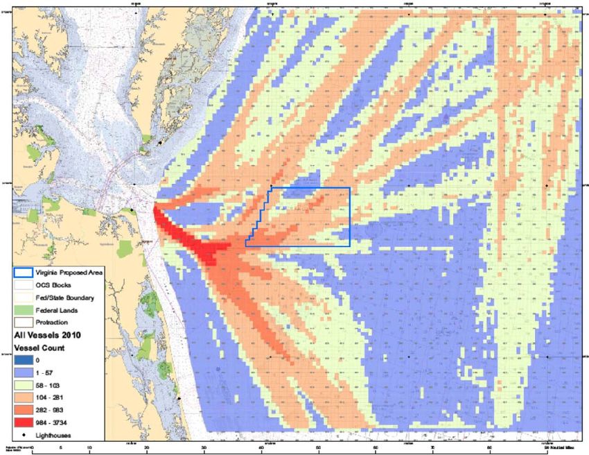
Executive Summary

        The Atlantic Coast Port Access Route Study Workgroup
(WG) was chartered on 11 May 2011, and was given three
objectives to complete within the limits of available resources: 1)
Determine whether the Coast Guard should initiate actions to
modify or create safety fairways, Traffic Separation Schemes
(TSSs) or other routing measures; 2) Provide data, tools and/or
methodology to assist in future determinations of waterways
suitability for proposed projects; and 3) Develop, in the near term,
AIS products and provide other support as necessary to assist
Districts with all emerging coastal and offshore energy projects.
The WG has conducted public and stakeholder outreach including
two public comments periods advertised in the Federal Register.
The WG has faced challenges in the lack of Coast Guard (CG)
capability to fully analyze AIS data and in identifying funding to
perform modeling and analysis. This resulted in an inability to
predict changes in traffic patterns or determine the resultant change
in navigational safety risk given different siting scenarios of
offshore renewable energy installations. However, the WG has
developed a methodology for initially classifying lease blocks as:
not suitable (Red), may be suitable with more study (Yellow) or
suitable (Green), based on proximity to shipping routes. This
methodology has been used by the CG to provide input to the
Bureau of Ocean Energy Management (BOEM) regarding the
potential impact to navigation of areas being proposed for wind
energy development. The WG has determined, given the lack of
complete AIS data and rudimentary analysis to date, that
recommending even preliminary routing measures is not
appropriate at this time. The WG has concluded that modeling and
analysis, as described in the Phase 3 of the following report, is
critical to determine if routing measures are appropriate and to
evaluate the change in navigational safety risk resulting from
different siting and routing scenarios. The CG is working with
BOEM to develop a project to perform the Phase 3 modeling and
analysis. This project is scheduled to begin in late summer, 2012.
The Coast Guard is also contracting the services of a GIS analyst
to support efforts to better characterize vessel traffic and further
explore creating initial proposals for routing measures independent
of the Phase 3 modeling and analysis.

                                  i
Table of Contents
A. Purpose                                                       1

B. Background                                                    2

C. Statutory Authority and International Guidelines              3

D. Study Approach                                                5

E. Status Summary                                                8

   1.   Phase 1- Status of Data Gathering                        8
   2.   Phase 2- Status of Applying Suitability Criteria         12
   3.   Phase 3- Status of Modeling and Analysis                 14
   4.   Phase 4- Implementation of Study Results                 15

F. Summary and Conclusions                                       16

   1.   Impact to Shipping                                       16
   2.   Establishment of Wind Energy Areas                       16
   3.   Risks of Postponing Assessment of Navigational Impacts   17
   4.   Other Offshore Energy Installations                      17
   5.   Tug and Barge Routes                                     18
   6.   Deep Draft Routes                                        18
   7.   Cumulative Impacts of Wind Farms                         18
   8.   Establishment of Routing Measures                        19

G. Recommendations                                               20

                                     ii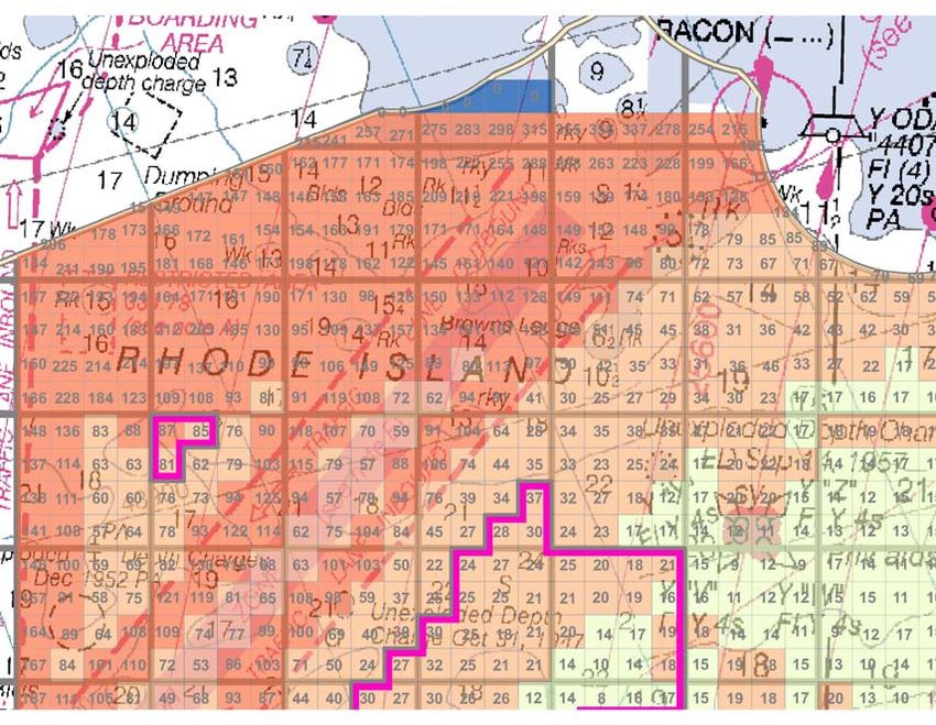
Appendices
Appendix I – Definition of Terms

Appendix II – Acronyms

Appendix III – Coast Guard Efforts to Determine Traditional Shipping Routes using AIS Data

Appendix IV – Summary of Public Comments

Appendix V – Stakeholder and Public Outreach

Appendix VI – The Marine Transportation System

Appendix VII – Applications of the Red–Yellow–Green Methodology

Appendix VIII – Preliminary Routing Measures

Appendix IX – Triton Knoll Wind Farm Predictive Analysis

                                   List of Enclosures

Enclosure 1 - Atlantic Coast Port Access Route Team Charter

Enclosure 2 – Red-Yellow-Green Methodology

Enclosure 3 – Red-Yellow-Green Determination for Maryland

Enclosure 4 – Red-Yellow-Green Determination for Massachusetts – Rhode Island
              Area of Mutual Interest

Enclosure 5 – Red-Yellow-Green Determination for Virginia

Enclosure 6 – Red-Yellow-Green Determination for North Carolina

                                             iii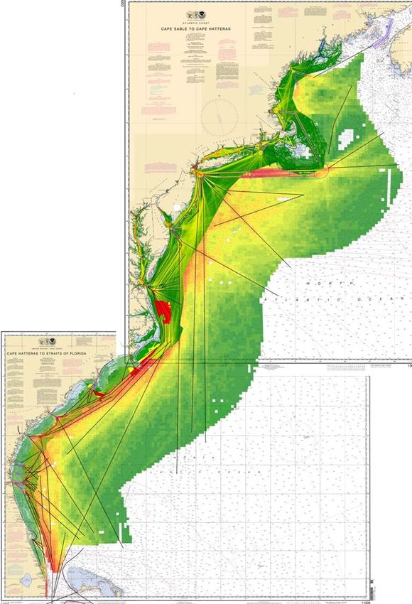
A.     Purpose

        The United States Coast Guard Deputy Commandant for Operations and the Commander,
Atlantic Area jointly chartered the Atlantic Coast Port Access Route Study (ACPARS) team on
11 May 2011 (Enclosure 1). The team was chartered to address the potential navigational safety
risks associated with the development of offshore renewable energy installations (primarily wind
farms) and to support future marine spatial planning efforts. The team, referred to as the
ACPARS workgroup (WG), was given three objectives to complete within the limits of available
resources: 1) Determine whether the Coast Guard should initiate actions to modify or create
safety fairways, Traffic Separation Schemes (TSSs) or other routing measures; 2) Provide data,
tools and/or methodology to assist in future determinations of waterways suitability for proposed
projects; and 3) Develop, in the near term, AIS products and provide other support as necessary
to assist Districts with all emerging coastal and offshore energy projects.

        The WG consisted of waterways management professionals from existing staffs at the
Headquarters, Area and District levels. The WG was given one year to complete the study. This
timeline was not met due primarily to shortfalls in resources to conduct the required modeling
and analysis. The need for modeling and analysis was identified at the beginning of the study,
and further reinforced as the study progressed, as being critical to evaluating changes in
navigational risk. The purpose of this interim report is to provide a status of the project over the
first year and discuss what remains to be accomplished.

                                                 1
B.         Background

        The ACPARS was initiated to study the navigational uses off the Atlantic Coast in
support of the Department of Interior’s (DOI) “Smart from the Start” initiative and provide data
to support future Coastal and Marine Spatial Planning (CMSP) efforts. The ACPARS study area
includes the entire Atlantic Coast (Maine to Florida) and is not focused on the port areas from
the sea buoy into the port like a typical port access route study. It is focused on those waters
located seaward of the existing port approach systems within the Exclusive Economic Zone
(EEZ). The intent of the Atlantic Coast PARS is to identify all current and anticipated new users
of the Western Atlantic near coastal zone, and determine what impact the siting, construction and
operation of proposed alternative energy facilities may have on existing near coastal users and
whether routing measures should be modified or created to ensure the safety of navigation.

        DOI’s “Smart from the Start” wind energy initiative for the Atlantic Outer Continental
Shelf was launched in November 2010 “to accelerate siting, leasing and construction of new
projects.”1 This initiative includes three key elements: (1) Eliminating a redundant step from the
REAU rule; (2) identifying Wind Energy Areas (WEA) to be analyzed in an environmental
assessment (EA) (prepared pursuant to the National Environmental Policy Act (NEPA)
(42U.S.C. 4321 et seq.)) for the purpose of supporting lease issuance and site assessment
activities; and (3) proceeding on a parallel track to process offshore transmission proposals.
BOEM describes a WEA as an OCS area that appears to be suitable for commercial wind energy
leasing. WEAs are delineated following deliberation and consultation with intergovernmental
renewable energy state task forces.2

         As of the date of this interim report, WEAs have been identified or areas of interest have
been considered off the coasts of Massachusetts, Rhode Island, New Jersey, Delaware,
Maryland, Virginia and North Carolina. The identified WEAs were located at or near the
entrances to major ports because the wind energy potential in these areas is suitable for possible
commercial exploitation. In these areas the depth of water is adequate for wind farm
construction and there is landside electrical energy infrastructure within acceptable distances to
connect to the wind farms. The initial locations of some of the identified WEAs were at or near
the seaward terminus of existing TSSs. Other WEAs were located in or very near the traditional
routes used by vessels in foreign trade and on Atlantic coastwise transits. The impact to safe and
efficient navigation appeared to be significant, although it had not been fully characterized. To
ensure safety of navigation, the Coast Guard needs to fully characterize the impacts of rerouting
traffic, funneling traffic, and placement of structures that may obstruct navigation. Some of the
impacts may include increased vessel traffic density, more restricted offshore vessel routing
(seaward of pilotage areas), fixed navigation obstructions, underwater cable hazards, and other
economic impacts. Analyzing the various impacts requires a thorough understanding of the
interrelationships of shipping and other commercial uses, recreational uses, and port operations.

1
  DOI Press Release dated 23NOV2010, “Salazar Launches ‘Smart from the Start’ Initiative to Speed Offshore
Wind Energy Development off the Atlantic Coast” http://www.doi.gov/news/pressreleases/Salazar-Launches-Smart-
from-the-Start-Initiative-to-Speed-Offshore-Wind-Energy-Development-off-the-Atlantic-Coast.cfm
2
    Federal Register, Volume 77, No.23, February 3, 2012.

                                                            2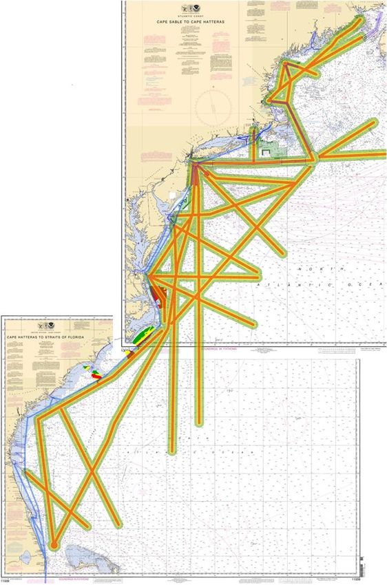
C.         Statutory Authority and International Guidelines

      1. Routing Measures

    The Ports and Waterways Safety Act (PWSA) (33 U.S.C. 1223(c)) authorizes the Secretary
of the Department in which the Coast Guard resides, to designate necessary fairways and traffic
separation schemes (TSSs) to provide safe access routes for vessels proceeding to and from
United States ports. The designation of fairways and TSSs recognizes the paramount right of
navigation over all other uses in the designated areas.

    The PWSA requires the Coast Guard to conduct a study of potential traffic density and assess
the need for safe access routes for vessels, before establishing or adjusting fairways or TSSs.
These studies are referred to as Port Access Route Studies (PARS). Through the study process
the Coast Guard must coordinate with Federal, State, and foreign state agencies (as appropriate)
and consider the views of maritime community representatives, environmental groups, and other
interested stakeholders. A primary purpose of this coordination is, to the extent practicable, to
reconcile the need for safe access routes with other reasonable waterway uses such as
construction and operation of renewable energy facilities and other uses of the Atlantic Ocean in
the study area.

    The International Maritime Organization (IMO) is the only recognized international body for
developing guidelines, criteria and regulations on an international level concerning routing and
areas to be avoided by ships. IMO states the purpose of ships’ routing is “to improve the safety
of navigation in converging areas and in areas where the density of traffic is great or where the
freedom of movement of shipping is inhibited by restricted sea room, the existence of
obstructions to navigation, limited depths or unfavorable meteorological conditions.”3
Guidelines for establishing routing measures and areas to be avoided are contained in the IMO
“Ships’ Routeing” publication.

      2. Leasing of the Outer Continental Shelf

    The Energy Policy Act of 2005 amended the Outer Continental Shelf Lands Act to authorize
DOI to, in consultation with the Secretary of the Department in which the Coast Guard is
operating and other relevant departments and agencies of the Federal Government, grant a lease,
easement, or right of way on the Outer Continental Shelf (OCS) for alternate energy related uses
of the OCS that produce or support production, transportation, or transmission of energy sources
other than oil and gas (43 U.S.C. § 1337(p)(1)(C)).

3
    International Maritime Organization (IMO) Publication, “Ships’ Routeing,” 2010 Edition.

                                                          3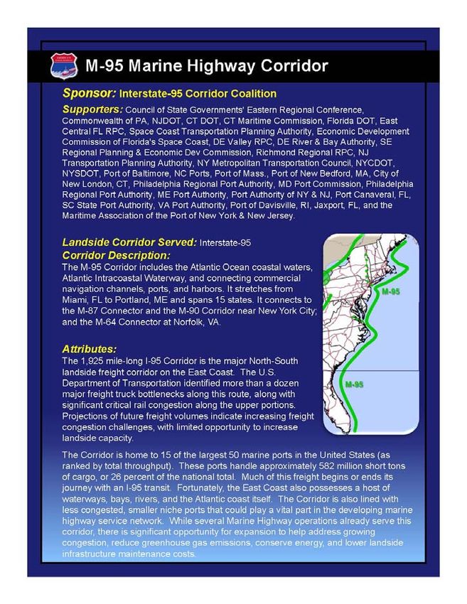
As the lead permitting agency, pursuant to the National Environmental Policy Act
(NEPA), 42 U.S.C. §§ 4321 et seq., BOEM is responsible for the development and preparation
of documentation for such activities on the OCS. BOEM and the USCG have entered into a
Memorandum of Agreement (MOA) to identify and clarify the roles and responsibilities of the
agencies for the issuance of leases and approval of Site Assessment Plans (SAPs), General
Activity Plans (GAPs) and Construction and Operations Plans (COPs) for offshore renewable
energy installations (OREIs). Under the MOA, BOEM will utilize the USCG’s expertise during
the NEPA process and invite the USCG to be a Cooperating Agency during the preparation of
NEPA documentation. The USCG will participate in the NEPA process as a subject matter
expert for maritime safety, maritime security, maritime mobility (management of maritime
traffic, commerce, and navigation), national defense, and protection of the marine environment.
During BOEM’s preparation of NEPA documentation, the USCG should participate at the
earliest possible time.4
       In addition to BOEM’s authorities, both the Federal Energy Regulatory Commission and
the U.S. Army Corps of Engineers (USACE) play roles in the permitting and licensing on the
OCS. FERC issues licenses under Part I of the Federal Power Act (FPA), 16 U.S.C. §§ 792-823a
(2006), and exemptions from licensing under Sections 405 and 408 of the Public Utility
Regulatory Policies Act of 1978, 16 U.S.C. §§ 2705 and 2708 (2006), for the construction and
operation of hydrokinetic projects on the OCS, and will conduct any necessary analyses,
including those under NEPA, related to those actions.

         The USACE will be the lead permitting agency for projects located within state waters.5
Section 10 (33 USC 403) of the Rivers and Harbors Act covers construction, excavation, or
deposition of materials in, over, or under such waters, or any work which would affect the
course, location, condition, or capacity of those waters. Activities requiring Section 10 permits
include structures (e.g., piers, wharfs, breakwaters, bulkheads, jetties, weirs, transmission lines)
and work such as dredging or disposal of dredged material, or excavation, filling, or other
modifications to the navigable waters of the United States. The geographic jurisdiction of the
Rivers and Harbors Act includes all navigable waters of the United States which are defined (33
CFR Part 329) as, "those waters that are subject to the ebb and flow of the tide and/or are
presently used, or have been used in the past, or may be susceptible to use to transport interstate
or foreign commerce." This jurisdiction extends seaward to include all ocean waters within a
zone three nautical miles from the coastline. However, the USACE authority extends beyond
three nautical miles to prevent obstructions to navigation in navigable waters of the United States
for artificial islands and fixed structures located on the outer continental shelf (43 U.S.C.
1333(e)).

4
  Memorandum of Agreement between the Bureau of Ocean Energy Management, Regulation and Enforcement –
U.S. Department of Interior and the U.S. Coast Guard – U.S. Department of Homeland Security, “Offshore
Renewable Energy Installations on the Outer Continental Shelf,” 27 July 2011.
5
  Along the Atlantic Coast state waters extend to 3 NM.

                                                   4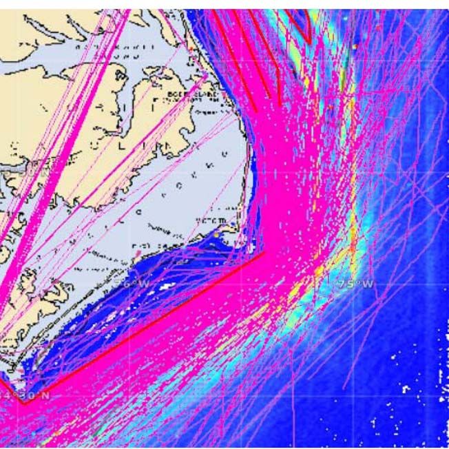
D.        Study Approach

        A Coast Guard workgroup was chartered to conduct the Atlantic Coast Port Access Route
Study (ACPARS). The ACPARS Workgroup (WG) is co-chaired by Deputy Commander,
Atlantic Area (LANT-09) and the Director, Marine Transportation Systems (CG-5PW)6. The
core group consists primarily of waterways management specialists from Coast Guard
Headquarters, Coast Guard Atlantic Area and Coast Guard Districts One, Five and Seven, but at
times also includes other personnel from supporting offices throughout the Coast Guard, the
National Oceanic and Atmospheric Administration (NOAA) and the Maritime Administration
(MARAD) as needed. The WG created a Project Management Plan consisting of Four Phases
that include:

   1. Phase 1- Data Gathering. In Phase 1, the WG will gather data on existing and future
waterway usage. This will be accomplished by:

             a. Determining traditional shipping routes using available Automatic Identification
         System (AIS) data and any other available data on maritime traffic patterns.;

              b. Combining AIS and other available data, analyzing to determine existing shipping
         routes and displaying routes in a geospatial format;

             c. Gathering additional data and information to identify existing and future
         waterways usage through public comments;

            d. Conducting stakeholder outreach through industry organizations and port level
         committees; and,

             e. Gathering maritime transportation system information from other federal
         agencies.

    2. Phase 2- Apply Suitability Criteria. In Phase 2, the WG would use the shipping routes
identified in Phase 1 and apply best available guidance (such as United Kingdom (UK) Maritime
Guidance Note MGN-371) to identify areas within the study area that are:

             a. Unsuitable for Offshore Renewable Energy Installations (OREIs) because of
         proximity to or location within existing routes;

              b. Potentially suitable for OREIs but require further study and analysis to
         determine if mitigation measures can reduce the navigational safety risk to tolerable
         levels; or,

             c. Potentially suitable for OREIs based on available data that suggest the
         navigational safety risk is acceptable without additional mitigation measures.

6
    CG-5PW was formerly CG-55

                                                   5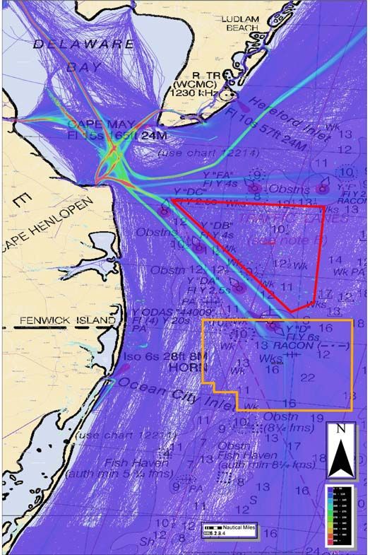
3. Phase 3- Modeling and Analysis. The WG recognized the need to conduct modeling and
analysis to predict changes in traffic patterns and determine the change in navigational risk due
to the complex interactions of the various factors that would impact navigational safety. The
tasks to be accomplished in Phase 3 were beyond the technical capabilities and capacity of the
WG and Coast Guard resources. Phase 3 would include:

            a. Developing a Geospatial Information System (GIS) based model to predict traffic
       density and traffic patterns that, incorporates the UK methodology7 or equivalent, to
       determine the resultant navigational safety risk given alternative siting scenarios and
       mitigating measures. The model should be able to identify the individual and cumulative
       effects on the Maritime Transportation System (MTS) along the Atlantic Coast;

            b. Assessing the resultant navigational safety risk associated with potential wind
       development areas with and without changes to routing measures or other navigational
       safety measures (pilotage, separation distances, regulated navigation areas, etc.);

            c. Conducting analyses of potential mitigating measures to determine if modifying
       existing or creating new routing measures, or implementing other navigational safety
       measures (pilotage, separation distances, regulated navigation areas, etc.) are necessary to
       reduce risk to within acceptable levels and to minimize overall impacts to the MTS;

            d. Evaluating options for the creation of coastwise routing measures and make
       recommendations for the creation of a system of routing measures that ensure navigational
       safety remains within acceptable limits while having the ability to accommodate multiple
       uses today and in the future; and,

            e. Publishing findings and recommendations in a final ACPARS Report.

7
 United Kingdom Department of Trade and Industry (DTI) “Guidance on the Assessment of the Impact of Offshore
Winds Farms: Methodology for Assessing the Impact of Wind Farms.”

                                                     6
4. Phase 4- Implementation of Study Recommendations.
a. Review the ACPARS report from Phase 3 to determine:
(1) If additional information is needed;
(2) If changes to routing measures or creation of new routing measures are
recommended; or,
(3) Whether other actions are necessary such as documentation of traditional
routes, changes in Coast Guard processes to determine suitability of proposed siting
or updates to the Coast Guard Navigational Vessel Inspection Circular for OREIs.
b. If no additional information is needed, issue a Notice of Study Results.
c. If additional information is needed, reopen the docket through a Federal Register
notice and conduct outreach and public meetings as necessary.
d. Initiate the regulatory process to create or modify any routing measures.
e. Initiate IMO processes as applicable to establish routing measures.
7E. Status Summary
1. Phase 1 – Status of Data Gathering
a. Determine Traditional Shipping Routes Based on AIS-
Automatic Identification System (AIS) data is the primary source of vessel transit data
available to the Coast Guard and the WG. The WG found that the Coast Guard AIS database
was designed to store large amounts of historical AIS data, but was not designed to extract and
analyze data. The ACPARS was the first effort by the Coast Guard to analyze AIS data on such
a large scale. As a result, the Coast Guard did not have the capability to process the AIS as
desired and the WG was not able to characterize vessel traffic to the extent that was needed. The
Coast Guard was able to produce some AIS products that enabled the WG to compare vessel
traffic to proposed wind energy areas.
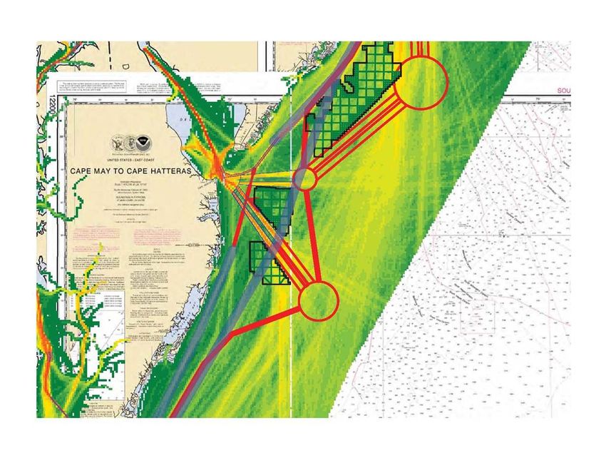
Figure 1- Heat Map of the Delaware
Bay Entrance with the Initial WEAs
proposed for Delaware and Maryland
“Heat map” is a term used for a
depiction of line density or point
density where the “hotter” color reflects
a higher density.
Source: NAVCEN
8Source: OSC
Figure 2 – Density Plot of the Entrance to Buzzard’s Bay
“Density Plots,” for the purposes of this report, refer to the number of vessels that
transited through a defined area (such as an aliquot8 or lease block) over a defined
period of time.
Available in the AIS data is several information fields including , but not limited to, the
vessel type, speed, direction, length, draft, and a time/date stamp. The heat maps and density
plots produced by the Coast Guard were primarily limited to only depicting all vessels for a one
year period. What the WG needed, but was unattainable to this point, is the ability to process the
AIS data by each of the individual information fields. See Appendix III for a detailed summary
of the efforts to acquire AIS products and the products that were produced.
8
An aliquot is 1/16 of a lease block.
9Figure 3 – Heat map of the East Coast
The Coast Guard Intelligence Coordination
Center estimates that there are about 156,000
movements of major vessels along the Atlantic
Coast each year, at any given time there are
4,500 vessels off the east coast.
Source: NOAA
b. Gather Information Through Public Comments
The Coast Guard published two formal requests for comments through the Federal
Register (see 76 FR 27288; May 11, 2011; Docket Number USCG-2011-0351). Twenty six (26)
submissions were received to the ACPARS docket during the first comment period and 103
submissions were received in the second comment period for a total of 129 submissions. Of the
129 submissions, 57 (45%) were determined to be outside the scope of the ACPARS and 3
others were duplicate submissions. A large majority of the submissions determined to be outside
the scope were specific to the Cape Wind project in Nantucket Sound which has already been
approved by BOEM.
The remaining submissions were reviewed and specific comments and/or
recommendations were identified, resulting in a total of almost 300 individual comments. These
comments were grouped into categories for organizational purposes. The categories included:
Anchorage, Assistance, Buffer/Buffer Zone/Separation Distance, Cost Benefit Analysis,
Environmental Impacts, Hazards, Navigational Aids, Precautionary Areas, Routes, Routing
Measures, Risk Assessment, Siting, and Watchstanding (shipboard). A summary of each
category of comments is included as Appendix IV. Please see the Federal Register Docket
Number USCG-2011-0351 for the actual submissions.
10c. Stakeholder and Public Outreach
In addition to the two formal requests for public comments, the WG has engaged and
continues to engage in an extensive outreach campaign seeking participation from local,
regional, national and international port and industry stakeholders. To achieve this, the WG has
taken several approaches to ensure the widest audience is reached.
1) LANTAREA, Districts and Sectors leveraged existing regional partnerships and
relationships between local Coast Guard units and local port partners to encourage
input to the study;
2) The WG conducted targeted outreach to the towing vessel community;
3) The WG sent letters to industry organizations to ensure awareness of the ACPARS
study;
4) The WG developed a website 9 to better communicate to all potential stakeholders
to bolster their outreach efforts; and,
5) National level outreach was conducted by the Coast Guard Marine Transportation
Systems Directorate (CG-5PW) to ensure partner agencies and national level
organizations were engaged.
A more detailed description of each of these efforts is included as Appendix V.
d. Gather Marine Transportation System Data
As part of the data gathering phase the WG explored the social and economic benefits of
the many uses of the waters off the Atlantic Coast including maritime trade, commercial fishing,
recreational fishing, tourism and recreation. A description of the MTS and its uses is included as
Appendix V.
In understanding the many varied uses of the MTS, it is important to consider future
trends, particularly as they pertain to balancing multiple uses. The WG identified three major
areas that may impact future uses of the Atlantic Coast waters including the expansion of the
Panama Canal, the Maritime Administration’s (MARAD) America’s Marine Highway Program,
and future exploitation of energy resources on the outer continental shelf. A description of each
of these and the potential effects on the MTS are also included in Appendix V.
9
http://www.uscg.mil/lantarea/acpars/
112. Phase 2- Status of Applying Suitability Criteria
The original intent in Phase 2 was to make an analytical determination of existing
shipping routes by analyzing the AIS data to determine routes that encompassed 95% of the
traffic (+ or- 2 standard deviations) traveling in the same or opposing directions.10 The WG
would then apply the R-Y-G methodology (described below) to make an initial determination of
where there is high, medium or low conflict for the entire study area. Due to the limitations in
the ability to process and analyze the AIS data described earlier or to identify funds for outside
assistance, the WG was unable to conduct the analytical determination of vessel routes and was
also unable to conduct an initial R-Y-G determination for the entire Atlantic offshore waters. As
a result the WG made subjective determinations (visual) using the AIS products described in
Phase 1 to apply the R-Y-G methodology to the proposed WEAs. The WG still desires an
analytical determination of traditional routes be completed as a starting point for determining
potential conflicts with vessel traffic. This task has been included in the statement of work for
Phase 3 as an interim product.
Red–Yellow–Green (R-Y-G) Methodology
As part of Phase 2 the WG developed a methodology based primarily on the UK Maritime
Guidance Note 371 to make preliminary determinations of suitability of proposed wind
development areas with regard to navigation. MGN 371 provided three break points between
WEAs and vessel traffic routes that were thought to be most significant and useful to this
determination:
¾ 1 NM - The minimum distance to the parallel boundary of a TSS. At this distance
there would still be S band radar interference and ARPA is affected. This is also the
boundary between High/Medium navigational safety risk.
¾ 2 NM – The distance where compliance with COLREGS becomes less
challenging, mitigation measures would still be required to reduce risk As Low As
Reasonably Practicable (ALARP). This is also the boundary between Medium/Low
navigational safety risk.
¾ 5 NM –The distance where there are minimal impacts to navigational safety and
risk should be acceptable without additional mitigation. This is also the boundary
between Low/Very Low navigational safety risk.
10
United Kingdom Department of Trade and Industry (DTI) Guidance on the Assessment of the Impact of Offshore
Winds Farms: Methodology for Assessing the Impact of Wind Farms, p.97. www.bis.gov.uk/files/file22888.pdf
12Figure 4 - Application of UK Maritime Guidance Note 371 for Red-Yellow-Green
Methodology
The workgroup selected the transition points where risk went from High to Medium (1 NM)
and from Low to Very Low (5 NM). Note there is still radar interference at 1.5 NM and
compliance with COLREGS is described as challenging out to 2NM. The reason for not taking a
more conservative approach with larger separation distances was the desire to initially leave as
much of the proposed areas as available for consideration by WEA developers early-on in the
process with the understanding that it would be an iterative process and more area could be
removed at a later time. For the leasing process BOEM is following, once lease blocks or
aliquots were removed from consideration they would no longer be considered. A full
description of how the R-Y-G Methodology was developed and the step by step procedure for
designating areas as red, yellow or green is included as Enclosure 2.
To date, R-Y-G Determinations have been completed for Maryland (MD), Massachusetts
(MA)/Rhode Island (RI) Area of Mutual Interest (AMI), Virginia (VA) and North Carolina
(NC). The majority of the areas, that remain for consideration, have been designated as Yellow,
and therefore, require additional analysis to determine if impacts to navigational safety risk can
be mitigated to within acceptable limits. Description of the process and results for each of these
determinations is included as Appendix VI.
133. Phase 3- Status of Modeling and Analysis
a. Develop a GIS based model to predict changes in traffic patterns and determine
navigational safety risk
From the very first ACPARS White Paper drafted in January, 2011, the WG understood
that for the Coast Guard to make appropriate recommendations to BOEM with regard to impacts
to navigation, a modeling solution must be employed that examines how the dynamics of marine
transportation would change in response to a wind installation. The WG surveyed the European
markets and looked for guidance from the more mature projects regulators and developers. The
science of navigational impact assessments has evolved in Europe to match pace with the
advancing OREI environment. The UK methodology, “Guidance on the Assessment of the
Impact of Offshore Winds Farms: Methodology for Assessing the Impact of Wind Farms” was
identified as the best available guidance. (An excellent example of a more recent application of
the methodology was in the preparation of the Marine Navigational Risk Assessment for the
Triton Knoll Offshore Wind Farm. See Appendix IX for a description of the Triton Knoll
assessment.)
Knowing that the modeling and analysis were beyond the capabilities of the Coast Guard,
the WG drafted a Statement of Work (SOW) that incorporated the concepts of the assessments
being conducted in Europe. The WG used the SOW to solicit three cost estimates. From that
solicitation the WG received two detailed proposals and cost estimates; both estimates were in
the $1.4M range. However, funding for Phase 3 modeling and analysis was not identified within
existing budgets. The Coast Guard Director of Marine Transportation Systems articulated the
need for modeling and analysis to the DOI Deputy Assistant Secretary for Land and Minerals
and the BOEM Renewable Energy Program Manager at a meeting in March, 2011. At the
meeting DOI/BOEM acknowledged the need and agreed to identify the funding to accomplish
Phase 3 modeling and analysis.
BOEM expressed an interest in funding the contract directly, using one of the Department
of Energy (DOE) National Labs. The WG has worked closely with BOEM staff to develop a
detailed SOW and review/evaluate proposals. The WG will continue to work with BOEM and
the Lab throughout the process to ensure the products produced will provide the information
necessary to facilitate decisions on siting and establishment of routing measures as appropriate.
The kickoff meeting is being scheduled for late summer 2012 and the modeling and analysis is
expected to take approximately 18-24 months.
b. Evaluate options for creation of routing measures.
Although the intent of Phase 3 was to develop a GIS based model to predict changes in
traffic patterns and determine the resultant navigational safety risk in order to evaluate options
for routing measures, the WG made an attempt to identify preliminary recommendations for
routing measures. NOAA hosted the WG and provided assistance with displaying AIS data for
the entire study area. Given the available AIS data and comments from the public, the WG
strove to identify fundamentally apparent routes along the Atlantic Seaboard and into major port
areas.
14A very broad summary analysis indicates, in the current unimpeded environment, vessels
take roughly the same routes into major port areas. However, outside of harbor approach areas,
vessels take divergent routes depending on their destination and various factors that impact
safety, such as type (size) of vessel, and route characteristics such as depth of water, weather, sea
state, etc., resulting in many well-traveled, distinct offshore routes.
Viewing heat maps of the entire Atlantic Coast, the WG was able to identify numerous
discernable routes and other large areas of relatively high vessel concentrations where distinct
routes were not apparent. The WG attempted to document the myriad routes and quickly
realized it would not be possible to capture every traditional route. The WG found that if routes
were to be combined to reduce the total number to a manageable level, it would increase vessel
density and also result in the mixing of previously segregated vessel types (combining of slow
moving and fast moving vessels).
The WG does not have the capability to evaluate and quantify the impacts to navigational
safety without the modeling and analysis described in Phase 3. A conservative approach to
designating routing measures would quickly remove most of the wind energy areas already being
proposed, which is not in the interest of facilitating other uses.
The WG came to the conclusion that it would be inappropriate to propose even preliminary
routes based on incomplete AIS data and the rudimentary evaluation that has been completed to
date. The modeling and analysis portions of Phase 3 are necessary to determine if routing
measures would be appropriate.
4. Phase 4- Status of Implementing Study Results
Phase 4- Implementation of Study Results cannot be initiated until the completion of
Phase 3.
15F. Summary and Conclusions
The WG was given three objectives in the initial charter. The first objective, to determine
whether the Coast Guard should initiate actions to create or modify routing measures, cannot be
met without further analysis. The WG determined that modeling and analysis beyond the
capability of the WG is required to make these determinations- further detail is provided in
section H. The second objective, to provide data, tools and/or methodology to assist in future
determinations, has been partially met with the R-Y-G Methodology, but can be further
advanced with the envisioned modeling and analysis tools. The third objective, to develop AIS
products and support Districts with emerging coastal and offshore energy projects, has been met
to the best of the ability of the WG given the limited resources and capabilities. Additional
summaries and conclusions on specific topic areas are provided below.
1. Impact to Shipping
Although Phase 2 and 3 work has not been completed, it is clear that the placement of
structures on the Atlantic Coast Outer Continental Shelf, where previously no structures existed,
increases risk of a vessel allision (with a fixed object); and may increase risk of collision
between vessels and/or increase risk of a grounding. The risks will increase as a result of the
density of vessel traffic being increased through funneling and decreased sea space for
maneuverability. The density plots that have been created provide estimations of the total
number of vessels that transited through a particular aliquot over a one year period. What the
WG is unable to determine with the analysis to date, is how often vessels pass within close
range of each other, referred to as an encounter. The number of encounters would be a more
accurate estimation of risk of a collision than vessels per aliquot per year. Rerouting (displacing)
traffic may also increase the weather related casualty risk to smaller vessels engaged in coast
wise shipping by forcing them further offshore, where they will be subjected to larger sea states,
and where their transits will be commingled with deep draft vessels moving much faster.
2. Establishment of Wind Energy Areas
The R-Y-G Methodology provides a defensible process for the Coast Guard to evaluate
proposed WEAs. The methodology leaves areas with moderate conflicts available for further
study and potential leasing for site assessment and site characterization activities. This is
consistent with BOEM’s desire to leave as much area available for further study, because once
removed, areas will not be added back in during this round. A full navigational safety risk
assessment will be submitted later in the process as part of a wind developer's Construction and
Operations Plan (COP), which will further inform decisions as to the suitability of an area for
development. Identifying areas of moderate conflict, but allowing further analysis, is consistent
with comments from the Offshore Wind Development Coalition (OffshoreWindDC) and the
American Wind Energy Association (AWEA).
163. Risks of Postponing Assessment of Navigational Impacts
One of the tenets of the “Smart from the Start” initiative was to streamline the leasing
process by limiting the initial environmental analyses to evaluating the impacts due to site
assessment and site characterization activities. This allowed BOEM to conduct an
Environmental Assessment (EA) versus a much more in depth Environmental Impact Statement
(EIS); however, it also meant that impacts related to the construction and operation of a wind
farm would not be fully assessed until much later in the process. Given the management
decision to take a less conservative approach and leave as much area available for further study
until later in the process, the WG is concerned that this gives both the public and developers a
false sense that the WEA has in fact been approved and the siting of a WEA is fully acceptable
for wind development. Under the current BOEM plan, the impacts to vessel traffic would not be
fully evaluated until the preparation of an Environment Impact Statement (EIS) during the
approval process of the Construction and Operations Plan (COP). The Coast Guard has
recommended that the potential impacts to navigation from the construction of wind farms be
addressed as soon as possible for any area contemplated for development. 11,12,13,14 The
complexities of determining the impacts of the interaction of vessels and wind farms, the effects
of increased vessel density and the impacts of decreased sea room require an analysis beyond
what has been done to date. Only the site assessment and site characterization activities are
currently being evaluated prior to issuing a lease and not the impacts of the actual construction
and operation of the wind farm. The wind development interests have also expressed concern
about WEAs being further decreased later in the process, after significant resources have been
expended. This further reinforces the need to conduct analyses of navigational impacts early in
the process and is in keeping with the Smart from the Start initiative to identify areas of lowest
conflict for priority development.
4. Other Offshore Energy Installations
Although the current emphasis off the Atlantic Coast is for offshore wind energy, it is also
necessary to consider other exploration and exploitation activities that may occur in the study
area in the future, such as hydrokinetics or traditional oil, gas and mineral extraction. The
Administration’s15 and the Nation’s desire for energy independence, all point to further
exploration and exploitation of the vast energy potential available from the Atlantic Outer
Continental Shelf. This was further reinforced in a letter to President Barack Obama dated
March 13, 2012 from the Outer Continental Shelf (OCS) Governors Coalition urging the
Administration to speed up permitting and open new offshore areas for traditional and renewable
energy projects.
11
U. S. Coast Guard, Commandant CG-55 letter 16650 dated 06FEB12.
12
Comments from U. S. Coast Guard Fifth District BOEM-2011-0093-0005
13
Comments from U. S. Coast Guard Fifth District BOEM-2011-0058-0005
14
Comments from U. S. Coast Guard First District BOEM-2011-0097-0004
15
http://www.whitehouse.gov/sites/default/files/email-
files/fact_sheet_obama_administration_92s_all_of_the_above_a_windows_approach_to_american_energy.pdf
175. Tug and Barge Routes
Many factors affect the routes vessels take, but generally they take the most direct and safe
route. Smaller and slower moving vessels tend to transit closer to shore, whereas larger and
faster moving vessels tend to transit in deeper water further offshore. Based on initial
evaluations, the highest conflict between tug and barge routes and proposed WEAs occur along
the coastwise routes. Their routes vary based on weather, sea state and depth of water necessary
for the catenary to clear the bottom when towing astern. In many cases proposed WEAs, such as
at the entrance to Delaware Bay, if fully developed, could force tug and barges to transit further
inshore or offshore from their traditional routes. The offshore route would take them
approximately 35 miles offshore and into routes used by larger deep draft vessels. This is much
farther than they would normally transit, especially the smaller units. The alternative would
force them inshore across the entrance to the bay at the convergence of the TSSs and pilot
boarding areas, increasing traffic density and complicating crossing situations.
6. Deep Draft Routes.
Deep draft vessels travelling on coastwise routes appear to have less of a conflict with
proposed WEAs. However, the coastwise routes are located in prime areas suitable for the next
round of wind development in deeper water. It appears the biggest conflicts with deep draft
vessels will occur at the entrances to major port areas where wind farms are proposed at or near
harbor approaches. In the case of the proposed WEA for Virginia, a significant number of deep
draft vessels currently transit through the proposed area and alternative routes would need to be
evaluated for a wind farm project to be considered.
7. Cumulative Impacts of Wind Farms.
One of the primary objectives of conducting a PARS for the entire Atlantic Coast was
assessing the cumulative impacts of multiple winds farms on the marine transportation system.
Figure 5 below illustrates the entrance to Delaware Bay and the three WEAs proposed for the
area, represented by black grid-blocks. Each of the WEAs would displace vessel traffic,
funneling vessel traffic into smaller areas, increasing vessel density with concurrent increased
risk of collision, loss of property, loss of life and environmental damage.
18Source: NOAA
Figure 5 - Heat map of Delaware Bay entrance displaying NJ, DE and MD WEAs
Evaluating the cumulative impacts are also important to understand the cascading effects of how
one wind farm may change the routes and approaches to the next port or the next wind
development area. Determining how vessels would alter routes given new obstructions and
quantifying the resultant change in navigational risk remains beyond the capability of the WG.
8. Establishment of Routing Measures
The customary system of historic routes used by vessels transiting the Atlantic Seaboard is
very complex. Minor localized changes can be evaluated using local knowledge, stakeholder
input and basic risk assessment tools employed during a PARS. However, the scope of the
Atlantic Coast PARS far exceeds that of a typical PARS. Evaluating the positive and negative
impacts to navigation from significant changes, such as creating a routing system for the entire
Atlantic Coast, is well beyond the capabilities of the WG. The predictability provided by routing
measures needs to be balanced against increased risk due to increasing vessel density and mixing
previously segregated traffic. It is the opinion of the WG, and one supported in public comments
from both the offshore wind industry and the maritime shipping industry, that routing measures
should not be created without a full evaluation of the impacts.
Prior to initiating a rule making for routing measures, the Coast Guard would also need to
consider the environmental and economic impacts, in addition to navigational safety impacts,
that would result from the establishment of routing measures, particularly routing measures that
increase vessel density or time and distance. Environmental impacts could include deleterious
effects on air quality due to increased emissions or increased risk of marine casualties resulting
in release of oil and/or chemicals into the environment. Increased time and distance would result
in increased expense to ship goods. Effects on migratory species would also need to be
evaluated.
19G. Recommendations
1. The USCG should continue to partner with BOEM to accomplish the modeling and
analysis necessary to evaluate the impacts the proposed wind energy areas will have on other
users of the near coastal area, impacts to navigation safety, and the effectiveness of mitigating
measures to maximize the areas available for offshore renewable energy installations. The
sooner this is accomplished, the sooner developers and investors will have more certainty in
projecting feasibility of projects.
2. The ACPARS Workgroup should remain as chartered to support the study as necessary to
ensure coastal user concerns and navigational equities are addressed and work with BOEM to
engage the maritime community in efforts to identify data gaps, information needs and further
stakeholder outreach.
3. The USCG should continue outreach efforts with affected states and federal agencies, the
marine shipping industry, the wind energy industry and the general public.
4. With GIS analyst support, the ACPARS Workgroup should compare AIS data to the
routing measures recommended in public comments to determine if they are representative of
traditional routes.
5. With GIS analyst support, the ACPARS Workgroup should further explore the possibility
of developing recommended routing measures that reflect existing routes.
6. The USCG should continue its participation in BOEM Renewable Energy State Task
Forces and evaluate areas proposed for development using the best available information and
applying the Red–Yellow–Green Methodology to provide sound recommendations.
7. ACPARS Workgroup should draft the Final ACPARS Report and publish the Notice of
Study Results upon completion of Phase 3.
20Appendix I
Definition of Terms
The following definitions (except as noted by an asterisk) are from the International Maritime
Organization’s (IMO’s) publication “Ships’ Routeing,” Tenth Edition, 2010:
Area to be avoided (ATBA) means a routing measure comprising an area within defined
limits in which either navigation is particularly hazardous or it is exceptionally important to
avoid casualties and which should be avoided by all vessels, or certain classes of vessels.
Deep-water route means a route within defined limits, which has been accurately
surveyed for clearance of sea bottom and submerged obstacles as indicated on nautical charts.
Exclusive Economic Zone (EEZ)* means the zone established by Presidential
Proclamation 5030, dated March 10, 1983.
Fairway or shipping safety fairway* (33 CFR 166) means a lane or corridor in which no
artificial island or fixed structure, whether temporary or permanent, will be permitted.
Temporary underwater obstacles may be permitted under certain conditions described for
specific areas in Title 33 CFR 166, Subpart B. Aids to navigation approved by the U.S. Coast
Guard may be established in a fairway.
Inshore traffic zone means a routing measure comprising a designated area between the
landward boundary of a traffic separation scheme and the adjacent coast, to be used in
accordance with the provisions of Rule 10(d), as amended, of the International Regulations for
Preventing Collisions at Sea, 1972 (COLREGS).
Obstruction* (33 CFR 64.06) means anything that restricts, endangers, or interferes with
navigation.
Precautionary area means a routing measure comprising an area within defined limits
where vessels must navigate with particular caution and within which the direction of traffic flow
may be recommended.
Recommended route means a route of undefined width, for the convenience of vessels in
transit, which is often marked by centerline buoys.
Recommended track is a route which has been specially examined to ensure so far as
possible that it is free of dangers and along which vessels are advised to navigate.
Regulated Navigation Area (RNA)* means a water area within a defined boundary for
which regulations for vessels navigating within the area have been established under 33 CFR
165.
1Appendix I
Definition of Terms
Roundabout means a routing measure comprising a separation point or circular separation
zone and a circular traffic lane within defined limits. Traffic within the roundabout is separated
by moving in a counterclockwise direction around the separation point or zone.
Separation Zone or separation line means a zone or line separating the traffic lanes in
which vessels are proceeding in opposite or nearly opposite directions; or separating a traffic
lane from the adjacent sea area; or separating traffic lanes designated for particular classes of
vessels proceeding in the same direction.
Structures* (33 CFR 64.06) means any fixed or floating obstruction, intentionally placed
in the water, which may interfere with or restrict marine navigation.
Traffic lane means an area within defined limits in which one-way traffic is established.
Natural obstacles, including those forming separation zones may constitute a boundary.
Traffic Separation Scheme (TSS) means a routing measure aimed at the separation of
opposing streams of traffic by appropriate means and by the establishment of traffic lanes.
Two-way route means a route within defined limits inside which two-way traffic is
established, aimed at providing safe passage of ships through waters where navigation is difficult
or dangerous.
Vessel routing system means any system of one or more routes or routing measure aimed
at reducing the risk of casualties; it includes traffic separation schemes, two-way routes,
recommended tracks, areas to be avoided, no anchoring areas, inshore traffic zones, roundabouts,
precautionary areas, and deep-water routes.
2Appendix II
Acronyms
ACPARS – Atlantic Coast Port Access Route Study
ATBA – Area to be Avoided
AIS – Automatic Identification System
ALARP – As Low As Reasonably Practicable
ARPA – Automatic Radar Plotting Aid
AWEA – American Wind Energy Association
BOEM – Bureau of Ocean Energy Management
CFI – Call for Information and Nominations
CFR – Code of Federal Regulations
CMSP – Coastal and Marine Spatial Planning
COLREGS - International Regulations for Preventing Collisions at Sea 1972
COP – Construction and Operations Plan
DOE – Department of Energy
DOI – Department of the Interior
EEZ – Exclusive Economic Zone
EIS – Environmental Impact Statement
FAQ – Frequently Asked Questions
FR – Federal Register
GAP – General Activity Plan
GIS – Geographic Information System
IMO – International Maritime Organization
LANTAREA – Atlantic Area
MARAD – Maritime Administration
MOA – Memorandum of Agreement
MTS – Marine Transportation System
NAVCEN – Coast Guard Navigation Center
NEPA – National Environmental Policy Act
NM – Nautical Mile
NOAA – National Oceanic and Atmospheric Administration
OCS – Outer Continental Shelf
OREI – Offshore Renewable Energy Installation
OSC – Coast Guard Operations Systems Center
PARS – Port Access Route Study
PWSA – Ports and Waterways Safety Act
RFI – Request for Interest
R&DC – Coast Guard Research and Development Center
RNA – Regulated Navigation Area
SAP – Site Assessment Plan
SOW – Statement of Work
TEU - Twenty-foot Equivalent Unit
TSS – Traffic Separation Scheme
UK DTI – United Kingdom Department of Trade and Industry
UK MGN – United Kingdom Maritime Guidance Note
USC – United States Code
1Appendix II
Acronyms
USCG – United States Coast Guard
WEA – Wind Energy Area
WG – Work Group
2Appendix III
Coast Guard efforts to determine traditional shipping routes using Automatic
Identification System (AIS) data
Automatic Identification System (AIS) data is the primary source of vessel transit data
available to the Coast Guard and the WG. The Coast Guard’s Nationwide Automatic
Identification System (NAIS) is a network of VHF receivers and transmitters designed to
increase Maritime Domain Awareness (MDA) in U.S. coastal and territorial waters by tracking
and communicating with AIS-equipped vessels.
The Maritime Transportation Security Act of 2002 allows the Coast Guard to collect
safety and security data from AIS-equipped vessels, and share that data with Coast Guard
operators and other government partners. NAIS receives 64 million AIS messages per day from
approximately 6,000 unique vessels in 58 ports and 11 coastal areas. Vessels required to carry
AIS include, but are not limited to: vessels over 300 gross tons; self-propelled vessels greater
than 65 feet engaged in commercial service and on an international voyage other than passenger
vessels and fishing vessels; and, passenger vessels of 150 gross tons or more on an international
voyage.16
The WG found that the Coast Guard AIS database was designed to store large amounts of
historical AIS data, but was not designed to extract and analyze data. The ACPARS was the first
effort by the Coast Guard to analyze AIS data on such a large scale. The Coast Guard
demonstrated the ability to manually extract and provide AIS data and products on a small scale,
but the Coast Guard does not have the capability or system in place to routinely extract and
analyze historical AIS data on a large scale.
Prior to initiation of the ACPARS, BOEM had already been processing 2009 AIS data to
inform the efforts of the individual Renewable Energy State Task Forces. These products were
presented at the task force meetings and used by the Coast Guard representatives to provide
initial recommendations. As the ACPARS WG was initially being formed, individual Districts
were also requesting additional AIS products directly from the Coast Guard Navigation Center
(NAVCEN). The products produced were generally in the form of heat maps such as the
following examples in Figures 6 and 7:
16
For a definitive list of vessels required to carry AIS see 33 Code of Federal Regulations Part 164
1Appendix III
Coast Guard efforts to determine traditional shipping routes using Automatic
Identification System (AIS) data
Source: NAVCEN
Figure 6 – Heat Map of the Mid-Atlantic showing the initial Delaware and Maryland
proposed WEAs
2Appendix III
Coast Guard efforts to determine traditional shipping routes using Automatic
Identification System (AIS) data
Source: NAVCEN
Figure 7 - Heat Map of Delaware Bay entrance showing the Delaware and Maryland initial
proposed WEAs
“Heat map” is a term used for a depiction of line density or point density where the
“hotter” color reflects a higher density. These initial products were useful as a starting point for
discussions at the BOEM Renewable Energy State Task Force meetings, but the ability of
NAVCEN to keep up with the demand for AIS products quickly overwhelmed the system.
Historical data requests can require substantial expenditure of time and/or level of effort to
produce data, depending on the nature of the request. For example; a request for a heat map
in a discrete area (such as at the entrance to a port), for a period of one month, might take 5-7
days to produce.
3You can also read