Report on Earthquake-Induced Landslides, Guatemala City
←
→
Page content transcription
If your browser does not render page correctly, please read the page content below
Report on Earthquake-
     Induced Landslides,
       Guatemala City
         Jonah Stinson, MS
         Scott Miles, Ph.D.
         February 2010

         Prepared for Oxfam-Great Britain, Guatemala Country Office
         Resilience Institute Working Paper 2010_3

                                            Western Washington University, 516 High Street,
                                           Bellingham WA 98225-9085 USA|+1 360.650.2707
1
                                                          www.wwu.edu/huxley/resilience
Guate Landslides - Stinson
                                                                                   Working Paper 2010_3
                                                                                           February 2010

                                         NOTES ON GIS ANALYSIS

Rock Strength Data
Rock strength information was incorporated by examining geologic data previously gathered for
landslide analysis of the study area. Using existing shapefiles, existing lithologies were grouped
into 5 categories based on material and likelihood for slope failure. (Those units showing the
greatest potential for sliding were categorized as 5). Any inconsistencies in the data (for
instance, the same lithology units occasionally being mapped as having differing potential for
sliding) were reviewed and edited, using the presence of mapped slides to help in instances of
conflicting data.

After reviewing literature sources comparing relative soil strength values of common sub-surface
materials (such as Selby 1983 and Harp et al.1981), we derived the following strength value
estimations to best represent the ground conditions present within the study area.

 Classification of Rock Strength Parameters:__________________________                 ____
                                              Phi Angle   Unit Weight (kN/m3)   Cohesion (Kpa)
 1 Alluvium, (Quaternary)                      32                       19             0
 2 Andesites, rocas volcanicas, Dacita         42                       26             35000
 (Tertiary, Cretaceous)
 3 pomez, tefra diamictones pomaceos           35                      17              35
 (Quaternary)
 4 tefra, pomez gris a blanco                  35                      17              35
  (Quaternary)
 5 pomez, tefra interestratificada,            35                      17              35
 (Quaternary)

                                                    2
Guate Landslides - Stinson
Working Paper 2010_3
February 2010
Table from M.J. Selby’s Slope Materials and Processes (1983).
3Guate Landslides - Stinson
Working Paper 2010_3
February 2010
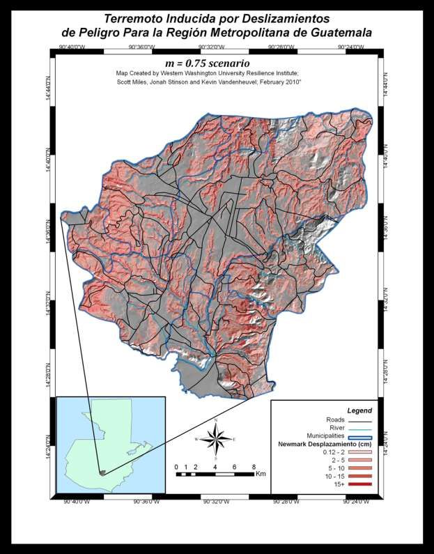
Newmark Displacement Calculations
Predicted Newmark Displacement values were modeled using an assortment of raster-based
analysis techniques. The following expounds upon specific input parameters used in the model
construction.
Magnitude
An earthquake event representing a moment magnitude (M) of 7.5 was selected for the
analysis. Reasons for using an M 7.5 event are twofold. Firstly, this presents a similar magnitude
to the 1976 event, which was centered approximately 160km NE of Guatemala City. Secondly,
choosing the same 7.5 magnitude as that which appears in other works (Villagran et al. 1997)
allows for direct comparison of modeling capabilities between works.
Fault Selection
Review of existing literature revealed the Micxo fault zone as the fault system closest to the
study area. This fault zone is composed of low angle, en echelon thrust faults trending N10-
N20 degrees E. Due to the close proximity to Guatemala City and the association of secondary
movement along these faults during the 1976 event, parts of the Mixco fault zone were chosen
as the source for earthquake initiation for this study. A series of faults closely grouped together
and located in the northwest portions of the study area were used to construct an approximate
zone of origin for modeling purposes.
Moisture
Scenarios were run in which two levels of saturation (m) were represented. (“m” represents a
dimensionless ratio between the height of watertable above failure surface, and the depth of
failure surface below ground surface) The first run, with an m value 0.25, represents relatively
drier moisture conditions which may be found during months like May and June. The second
scenario calculated with an m value of 0.75 represents wetter ground conditions, and may be
representative of conditions found during the rainy season months such as August and
September.
Depth of Failure
An average value of 3.33m was chosen to represent depth of failure below the surface. This
values appears commonly in earthquake-induced landslide modeling works such as Keefer 1984
and Miles and Keefer 1999.
Factor of Safety
Using the infinite slope model, the static factor of safety of a slope (FS) can be expressed as:
FS = _c’_____ + tan '____ - m w tan '__
z sin tan tan
Where:
4Guate Landslides - Stinson
Working Paper 2010_3
February 2010
c’ = effective cohesion (Pa= N/m2).
= unit weight of soil (N/m3).
m = zw/z (dimensionless).
3
w = unit weight of water (N/m ).
z = depth of failure surface below the surface (m):
zw = height of watertable above failure surface (m).
= slope surface inclination (°).
' = effective angle of shearing resistance (°) aka friction angle.
Ground Motion Attenuation Relationship
A strong motion attenuation relationship developed by Climent et al. (1994) and used in
Villagran et al. (1997) was used to derive the following relation for peak ground acceleration
(PGA);
Where PGA is in m s-2, M is the moment magnitude of 7.5, R is the hypocentral distance (km),
and S is a site factor with 1 for soil (anything listed as Quaternary) and 0 for rock.
Newmark Displacement
We used the following equation developed by Randall Jibson (2007) to calculate Newmark
Displacement as a function of critical acceleration ratio and moment magnitude;
Where critical acceleration = (FS -1) sin . Final displacements for the two moisture scenarios
were mapped to show displacement in centimeters, with maps masking out areas of slope
surfaces ≤ 5 degrees.
5Guate Landslides - Stinson
Working Paper 2010_3
February 2010
NEWMARK DISPLACEMENT MAPS
6Guate Landslides - Stinson
Working Paper 2010_3
February 2010
7Guate Landslides - Stinson
Working Paper 2010_3
February 2010
APPENDIX: BACKGROUND NOTES ON 1976 EVENT AND GEOTECHNICAL ASPECTS
’76 event: predominantly rock falls and debris slides of less than 15,000m3 volume.
Regional distribution depends on 5 factors: 1) seismic intensity, 2) lithology, 3) slope 4)
topographic amplification of seismic ground motion, 5) regional fractures.
Presence of pre-earthquake slides has no apparent effect on distribution
Epicenter in Montagua fault zone, runs E-W. Death toll in 76 could have been much higher if
slides had been on canyon slopes in heavily populated areas.
Highway blockages seriously hindered rescue efforts in the past.
The plateau that G.C. is built on is along the continental divide; deeply incised by canyons
“barrancos”. Plateau is underlain by Pleistocene Pumice deposits more than 100m thick, a
brittle material with low tensile strength. The interlocking texture of this provides enough shear
strength however to support nearly vertical slopes 100m high. More than 90 % of the slides in
76 were within these pumice deposits or their residual soils.
Debris slides were most abundant in areas where thin soil (Guate Landslides - Stinson
Working Paper 2010_3
February 2010
Pumice deposits are not welded or extensively cemented but have undergone some
compaction under their own weight. Thus the pumice has little cohesive strength and derives
most of the shear strength from high coefficient of friction (phi) due to angularity and
interlocking fabric of individual particles.
Near GC , soil thickness is commonly 1m thick, but thins out to 0.5m to the north within a
distance of 10km.
Slope- rockfalls generally occurred in steep (50+) areas, debris slides 35-30 degree slopes.
Particular areas hard hit were Rios Pixcaya, Motagua, Los Chocoyos, and Las Vacas. High
percentage of failures resulted from high dynamic stresses imposed by the amplification of
seismic waves by the existing canyon topography.
The tefras-product of airborne ash falls-are less dense, better sorted, lower tensile strength and
more friable than the ash-flow tuffs. Tuff units generally poorly sorted, unreworked, nearly
unstratified mixtures of coarse ash, pumice, and lithic fragments. Tephra units are generally
only a few meters thick in GC area, wheras ash-flow is bulk of basins. Lots of lateral variability in
thickness of pumice deposits though from canyon to canyon.
In the GC area, more rock falls than debris slides. Fractures exposed in the rock-fall scarps were
N10-N20 degrees E; this orientation approximately parallels the Mixco fault zone (echelon
faults)
Because few seismically induced landslides in GC in ‘76 were thicker than 10m, about 95% of
the landslide areas could have been avoided if dwellings had not been closer than 10m to the
canyon margins or had not been built along the canyon slopes below the plateau rim.
9Guate Landslides - Stinson
Working Paper 2010_3
February 2010
WORKS CITED
Climent, A. et al., 1994. Spectral strong motion attenuation relationship in Central America.
Technical Report No. 2-16, NORSAR.
Harp, E. et al. 1981. Landslides from the February 4, 1976, Guatemala earthquake/ conducted in
cooperation with the Government of Guatemala, under the auspices of the Agency for
International Development, U.S. Department of State. Washington, D.C. : U.S. Dept. of the
Interior, Geological Survey.
Jibson, R. 2007. Regression models for estimating coseismic landslide displacement,
Engineering Geology 91, 209-218.
Keefer, D., 1984. Landslides caused by earthquakes, Geological Society of America Bulletin, v 95,
p. 406-421.
Miles, S. and Keefer, D., 1999. Comparison of seismic slope-performance models: case study of
the Oakland East Quadrangle, California. U.S. Geological Survey Open-File Report 99-137.
Selby, M.J., 1983. Hillslope Materials and Processes, Oxford:Oxford University Press
Villagran, M. et al. 1997. Seismic Hazard Assessment for Guatemala City, Natural Hazards 14,
189-205.
10You can also read


