REPORT PLANNING & EXISTING CONDITIONS - City of Waterloo

Page created by Gene Patel
 
CONTINUE READING
REPORT PLANNING & EXISTING CONDITIONS - City of Waterloo
PLANNING & EXISTING
CONDITIONS
REPORT
Westhill District
City of Waterloo

Date:
December, 2018

Prepared by:
MacNaughton Hermsen Britton Clarkson Planning Limited (MHBC)
540 Bingemans Centre Drive, Suite 200
Kitchener, Ontario
T: 519.576.3650
F: 519.576.0121

Our File Y594E
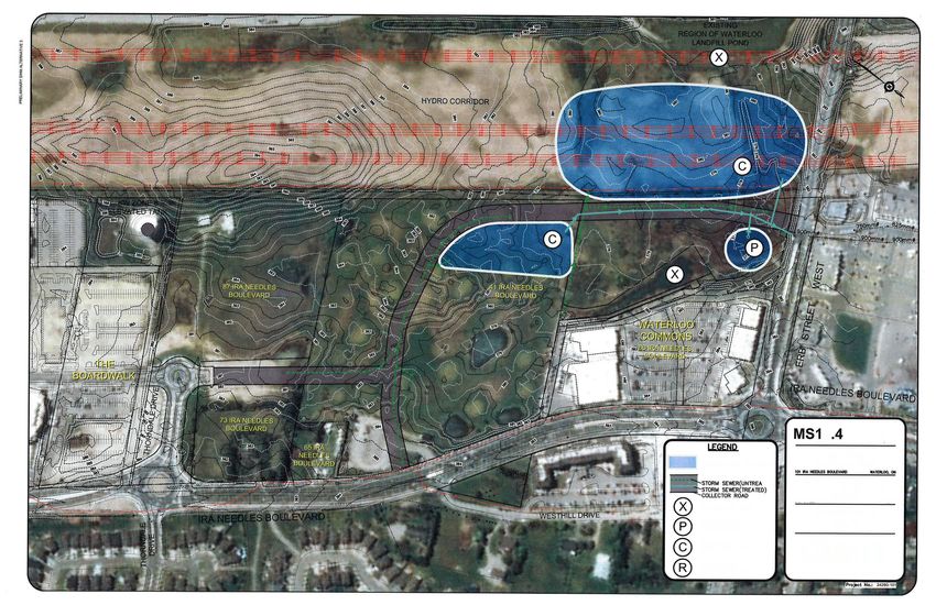
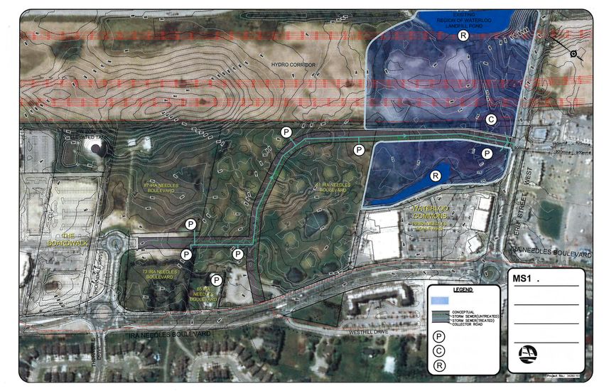
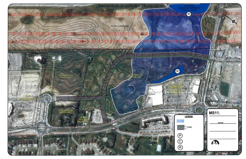
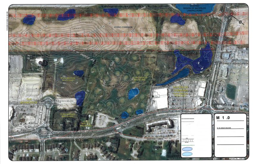
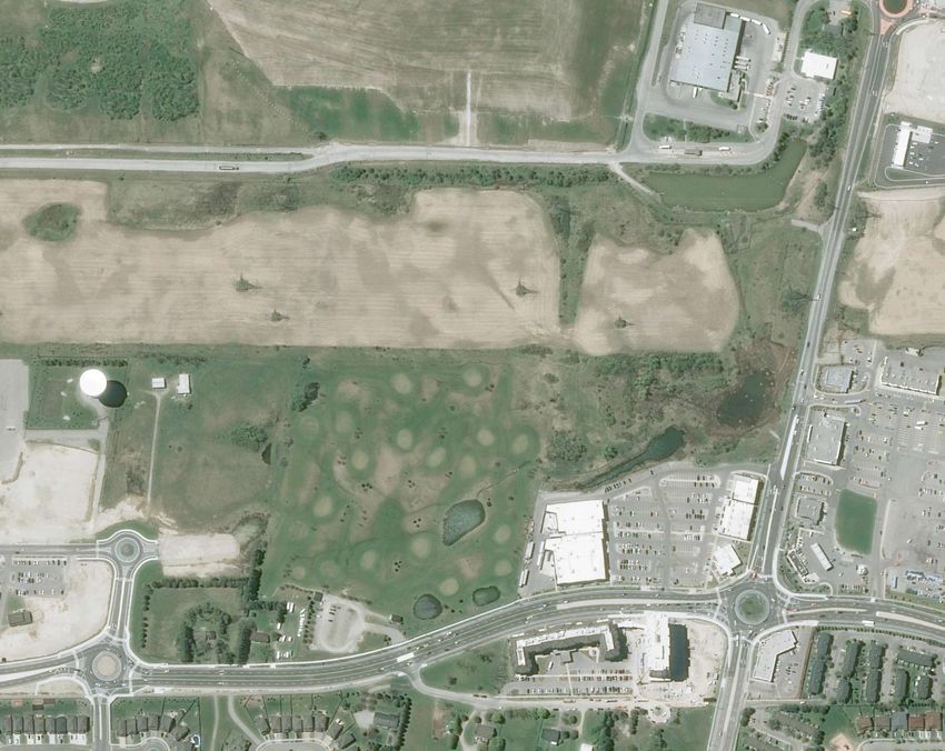
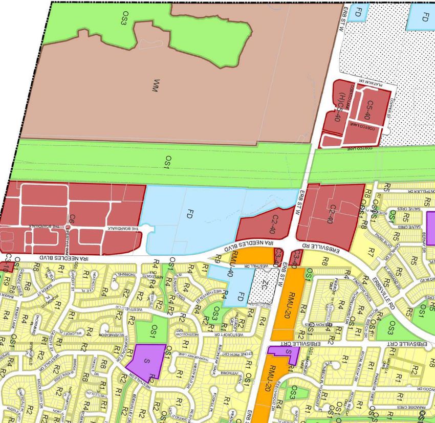
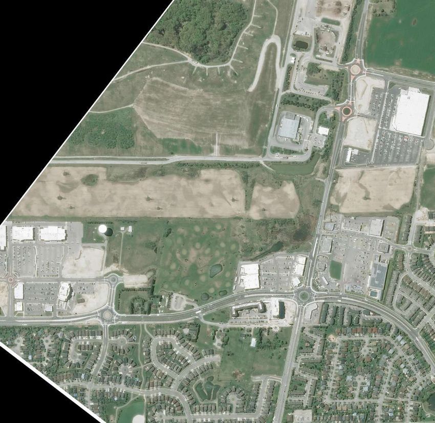
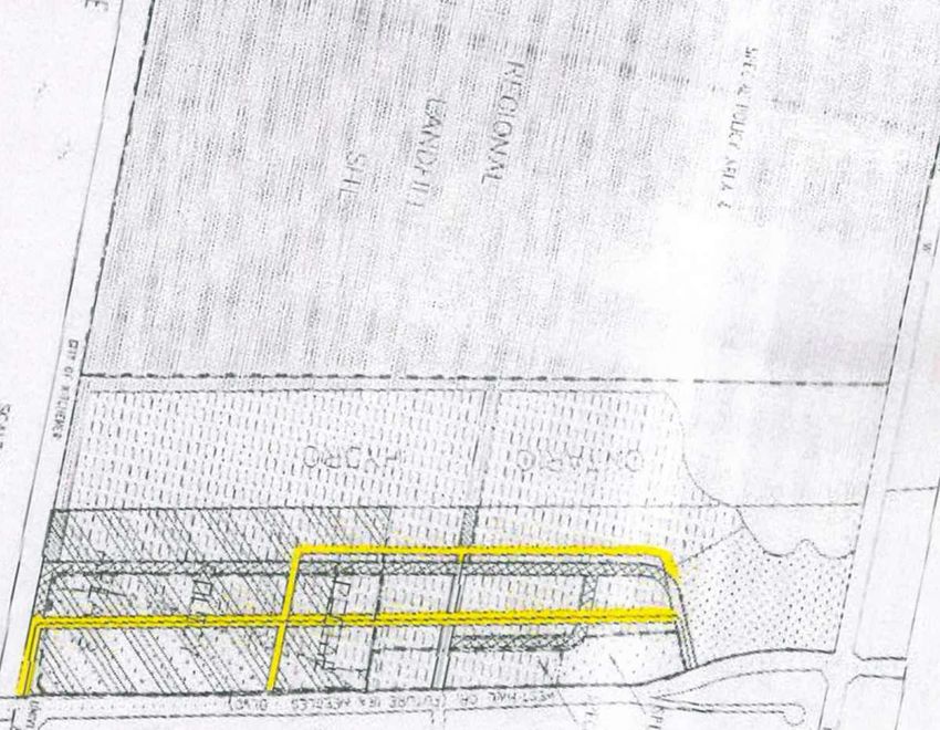
REPORT PLANNING & EXISTING CONDITIONS - City of Waterloo







REPORT PLANNING & EXISTING CONDITIONS - City of Waterloo







REPORT PLANNING & EXISTING CONDITIONS - City of Waterloo









Figure 1
                                                                                                                                                                   Property Ownership
                                                    REGION OF WATERLOO LANDFILL
                                                                                                                                                                   West Hill District
                                                                                                                                                                   City of Waterloo
                                                                                                                                                                   Region of Waterloo
                                                                                                                                                          COSTCO
                                                                                                                                                                   LEGEND

                                                                                                                                                    #9)
                                                                                                                                                     d.
                                                                                                                                                                                       Parcel Fabric (MPAC)

                                                                                                                                                eg. R
                                                                                                                                                                   The INCC Corp. Property Ownership

                                                                                                                                             . W. (R
                                                                                                                                                                                         Area by Property Ownership

                                                                                                                                                T
                                                                                                                                           ERB S
                                                                                                                                                                                Ownership                                *Area (ha) % of Total
                                                                                                                                                                                                                                      Area
                                                                                                                                                                            The INCC Corp.                                 0.40               2.5
                                                                                                                                                                   Waterloo Commons JV Inc.                                2.54**           15.8
                                                    HYDRO ONE LANDS                                                                           HYDRO ONE LANDS           1130814 Ontario Inc.                               5.13             31.9
                                                                                                                                                                          Home Hardware
                                                                                                                                                                                                                           7.99             49.8
                                                                                                                                                                        Development Limited
                                                                                                                                                                                                                 Total     16.06              100

                                                                                                                                                                   *Area based on Geowarehouse (Teranet) parcel mapping
                                                                                                                                                                   that was compiled using plans and documents recorded in
                                                                                                                                                                   the Land Registry System and is approximate.
                                                                                                                                                                   **Area includes 0.38 ha SWM Pond currently owned by the
                                                                                                                                                                   Region of Waterloo
                                                                                                             Waterloo Commons JV Inc.
                                                                                                                      2.16 ha

                                                                                                                       SWM
                                                                                                                      0.38 ha

                                                                                                                                           CANADIAN TIRE
                                                             Home Hardware Stores Limited                                                  DEVELOPMENT
                                                                       7.99 ha
                             1130814 Ontario Inc.
                                   5.13 ha

THE BOARDWALK
                         .
                  ALE DR

                                                            The INCC Corp.
                                                            0.40 ha
                                                                                                                                                                   Air Photo Source: Bing
                THORND

                                                                                                                                        ERBSVILLE RD.              DATE: December 2018

                                                                                                                                                                   FILE: Y594E
                                                                                        70)
                                                                                    d. #

                                                                                                                                                                                                                                         no
                                                                                                                                                                   SCALE: 1:3,000
                                                                                 .R

                                                                                                                                                                                                                                           rth
                                                                                g
                                                                             (Re                                                                                   DRAWN: DGS
                                                                                                                                                                        K:\Y594E WESTHILL DISTRICT PLAN\RPT\PLANNING REPORT DECEMBER 2018\PROPERTY

                                  IRA NEEDLES BLVD.                                                                                                                                                  OWNERSHIP MAP.DWG

                                                                                                                                                                                                                          PLANNING
                                                                                              WESTHILL DR.                                                                                                                URBAN DESIGN
                                                                                                                                                                                                                          & LANDSCAPE
                                                                                                                                                                                                        MHBC              ARCHITECTURE
                                                                                                                                                                                              X
                                                                                                                                                                                              3
                                                                                                                                                                                              9NO
                                                                                                                                                                                                N
                                                                                                                                                                                                C
                                                                                                                                                                                                B
                                                                                                                                                                                                2TG
                                                                                                                                                                                                  H
                                                                                                                                                                                                  N
                                                                                                                                                                                                  B
                                                                                                                                                                                                  IEM
                                                                                                                                                                                                    K
                                                                                                                                                                                                    ,IR
                                                                                                                                                                                                      E0
                                                                                                                                                                                                       4
                                                                                                                                                                                                       5D
                                                                                                                                                                                                        A
                                                                                                                                                                                                        C
                                                                                                                                                                                                        -0
                                                                                                                                                                                                         2N
                                                                                                                                                                                                          R
                                                                                                                                                                                                          .EST
                                                                                                                                                                                   W
                                                                                                                                                                                   |W
                                                                                                                                                                                    1
                                                                                                                                                                                    2
                                                                                                                                                                                    0.W
                                                                                                                                                                                      6
                                                                                                                                                                                      7
                                                                                                                                                                                      5M
                                                                                                                                                                                       .9
                                                                                                                                                                                        1
                                                                                                                                                                                        5H
                                                                                                                                                                                         B
                                                                                                                                                                                         C
                                                                                                                                                                                         AC
                                                                                                                                                                                          P
                                                                                                                                                                                          L:N
                                                                                                                                                                                            FO
                                                                                                                                                                                             .M
                                                                                                                                                                                              0
                                                                                                                                                                                              5
                                                                                                                                                                                              6
                                                                                                                                                                                              3.6
                                                                                                                                                                                                7
                                                                                                                                                                                                5.9
                                                                                                                                                                                                  1
                                                                                                                                                                                                  5P     :
REGION OF WATERLOO LANDFILL

                                                                                                                                                                                                          COSTCO

                                                                                                                                                                              . #9)
                                                                                                                                                                                d
                                                                                                                                                                           eg. R
                                                                                                                                                                             (R
                                                                                                                                                                       T. W.
                                                                                                                                                                  ERB S
                                  HYDRO ONE LANDS                                                                                                                                     HYDRO ONE LANDS

                                                                                                                                                                                                              BLVD.
                                                                                                                                                                                                            PARIS
                                                                                                                                                     CANADIAN TIRE DEVELOPMENT
                                                                                                  WATERLOO COMMONS
                                         LE DR.

           THE BOARDWALK
                                            A
                                     THORND

                                                                                                                                                      ERBSVILLE RD.
                                                                                              )
                                                                                           #70                                                                                        (Re
                                                                                g.   Rd.                                                                                                 g. R
                                                                            (Re                                                                                                              d. #
                                                                                                                                                                                                    70)
                                                  IRA NEEDLES BLVD.
                                                                                            WESTHILL DR.
                                                                                                                          9)
                                    R.

                                                                                                                    Rd. #
                                 LED
                              DA

                                                                                                                (Reg.
                             RN
                              O

                                                                                                              T. W.
                           TH

                                                                                                            ERB S

Figure 2                                                                                                                         DATE: December 2018
                                                   LEGEND
Study Area Map
                                                                    The Boardwalk                                                SCALE: 1:7,500
                                                                                                                                                                                                                    no
                                                                                                                                                                                                                       rth
                                                                    Study Area                                                   FILE: Y594E

                                                                                                                                  DRAWN: DGS

                                                                                                                               K:\Y594E WESTHILL DISTRICT PLAN\RPT\PLANNING REPORT DECEMBER 2018\STUDY AREA
                                                                                                                                                                   MAP.DWG

                                                                                                                                                                                        PLANNING
                                                                                                                                                                                        URBAN DESIGN
West Hill District                                                                                                                                                                      & LANDSCAPE
City of Waterloo                                                                                                                                                    MHBC                ARCHITECTURE
                                                                                                                                               9
                                                                                                                                               X3N
                                                                                                                                                 B
                                                                                                                                                 2ON
                                                                                                                                                   ,C
                                                                                                                                                    TN
                                                                                                                                                     H
                                                                                                                                                     ,R
                                                                                                                                                      EIKN DG
                                                                                                                                                            .R
                                                                                                                                                             M
                                                                                                                                                             IE
                                                                                                                                                              B
                                                                                                                                                              C
                                                                                                                                                              E
                                                                                                                                                              R
                                                                                                                                                              NAETN
                                                                                                                                                                  04
                                                                                                                                                                   S5-02
Region of Waterloo                                 Air Photo Source: Bing
                                                                                                                                   W
                                                                                                                                   |
                                                                                                                                   W1
                                                                                                                                    W
                                                                                                                                    M
                                                                                                                                    210C
                                                                                                                                       H
                                                                                                                                       .A
                                                                                                                                        B.O
                                                                                                                                          N
                                                                                                                                          L6
                                                                                                                                           P
                                                                                                                                           7
                                                                                                                                           .5M
                                                                                                                                             .915 :F 0563.675.915 :P




IRA NEEDLES BLVD

                                                                                                                                ERBSVILLE RD

Figure 3                                                                               DATE: December 2018
                       LEGEND
Region of Waterloo
                                       Subject Lands                                   FILE: Y594E
Official Plan                                                                                                                                            no
                                                                                                                                                            rth
Urban Area                                                                             SCALE: 1:30,000
Map 3a
                                                                                       DRAWN: DGS

                                                                                       K:\Y594E WESTHILL DISTRICT PLAN\RPT\PLANNING REPORT DECEMBER 2018\ROP MAP 3A
                                                                                                                       URBAN AREA.DWG

                                                                                                                                    PLANNING
                                                                                                                                    URBAN DESIGN
West Hill District                                                                                                                  & LANDSCAPE
City of Waterloo                                                                                                         MHBC       ARCHITECTURE
                     Base Map Source:                                                               9
                                                                                                    X3N
                                                                                                      B
                                                                                                      2ON
                                                                                                        ,C
                                                                                                         TN
                                                                                                          H
                                                                                                          ,R
                                                                                                           EIKN DG
                                                                                                                 .R
                                                                                                                  M
                                                                                                                  IE
                                                                                                                   B
                                                                                                                   C
                                                                                                                   E
                                                                                                                   RNA
                                                                                                                     ETN
                                                                                                                       04
                                                                                                                        S5-02
Region of Waterloo   Region of Waterloo Official Plan, Map 3a Urban Area (June 2015)
                                                                                        W
                                                                                        |
                                                                                        W1
                                                                                         W
                                                                                         M
                                                                                         210C
                                                                                            H
                                                                                            .A
                                                                                             B.O
                                                                                               N
                                                                                               L6
                                                                                                P
                                                                                                7
                                                                                                .5M
                                                                                                  .915 :F 0563.675.915 :P
IRA NEEDLES BLVD

                                                                                                                     ER
                                                                                                                        BS
                                                                                                                          VI
                                                                                                                            LL
                                                                                                                               E
                                                                                                                                   RD

Figure 4                                                                                                       DATE: December 2018
                                   LEGEND
City of Waterloo
                                                    Subject Lands                                              FILE: Y594E
Official Plan                                                                                                                                                                   no
                                                                                                                                                                                   rth
Land Use Plan                                                                                                  SCALE: 1:12,500
Schedule "A"
                                                                                                               DRAWN: DGS

                                                                                                               K:\Y594E WESTHILL DISTRICT PLAN\RPT\PLANNING REPORT DECEMBER 2018\WATERLOO
                                                                                                                                            OP LAND USE MAP.DWG

West Hill District
City of Waterloo
                                 Base Map Source:
Region of Waterloo               City of Waterloo Official Plan, Schedule "A" (Revision Date: November 2016)
IRA NEEDLES BLVD
                                                                           ER
                                                                             BS
                                                                               VI
                                                                                  LL
                                                                                  E
                                                                                   RD

                                                                                                                    Base Map Source:
                                                        City of Waterloo Official Plan, Schedule "A6" (Revision Date: November 2016)

Figure 5                                                            DATE: December 2018
                          LEGEND
City of Waterloo                        Subject Lands               FILE: Y594E
Official Plan                                                                                                                         no
                                                                                                                                         rth
Specific Provision                                                  SCALE: 1:12,500
Areas
                                                                    DRAWN: DGS
Schedule "A6"
                                                                     K:\Y594E WESTHILL DISTRICT PLAN\RPT\PLANNING REPORT DECEMBER 2018\WATERLOO
                                                                                            OP SPECIFIC PROVISION AREAS.DWG

West Hill District
City of Waterloo
Region of Waterloo
ER
                                                                                                                   BS
                                                                                                                     VIL
                     IRA NEEDLES BLVD                                                                                    LE
                                                                                                                              RD

Figure 6                                                                                                                DATE: December 2018
                                    LEGEND
City of Waterloo
                                                     Subject Lands                                                      FILE: Y594E
Official Plan                                                                                                                                                                            no
                                                                                                                                                                                            rth
Road Classification                                                                                                     SCALE: 1:12,500
System
                                                                                                                        DRAWN: DGS
Schedule "E"
                                                                                                                        K:\Y594E WESTHILL DISTRICT PLAN\RPT\PLANNING REPORT DECEMBER 2018\WATERLOO
                                                                                                                                            OP ROAD CLASSIFICATION SYSTEM MAP.DWG

West Hill District
City of Waterloo
                                  Base Map Source:
Region of Waterloo                City of Waterloo Official Plan, Schedule "E" (Revision Date: November 2016)
Figure 7                                                                                    DATE: December 2018
                         LEGEND
West Hill District
                                        Subject Lands                                       FILE: Y594E
Implementation Plan                                                                                                                                           no
                                                                                                                                                                   rth
Land Use Concept Plan                                                                       SCALE: NTS
Map 1
                                                                                            DRAWN: DGS

                                                                                            K:\Y594E WESTHILL DISTRICT PLAN\RPT\PLANNING REPORT DECEMBER 2018\WEST HILL
                                                                                                                 DISTRICT LAND USE CONCEPT PLAN.DWG

West Hill District
City of Waterloo
Region of Waterloo      Base Map Source: City of Waterloo DS-09-34, Map 9 (June 15, 2009)
THE BOARDWALK

                                                                                           NEEDLES BLVD
                                                                                     IRA
           IRA NEEDLES BLVD

Figure 8                                                                                                        DATE: December 2018
                                       LEGEND
City of Waterloo
                                                       Subject Lands                                            FILE: Y594E
Zoning By-law                                                                                                                                                                   no
                                                                                                                                                                                   rth
2018-050                                                                                                        SCALE: 1:10,000
Schedule "A"
                                                                                                                DRAWN: DGS

                                                                                                                K:\Y594E WESTHILL DISTRICT PLAN\RPT\PLANNING REPORT DECEMBER 2018\WATERLOO
                                                                                                                                                ZONING MAP.DWG

West Hill District
City of Waterloo
                                      Base Map Source:
Region of Waterloo                    City of Waterloo Zoning By-law, Zoning Map Schedule "A" (Sept.10, 2018)
Base Map Source:
WSP, Waterloo West Side Integrated Multi Modal Transportation Study [Draft]
City of Waterloo (June 2018) Figure 3-5

Figure 9                                                     LEGEND           DATE: December 2018

WATERLOO WEST SIDE
INTEGRATED MULTI MODAL                                                        FILE: Y594E
                                                                                                                                               no
TRANSPORTATION STUDY                                                                                                                              rth

Figure 3-5                                                                    SCALE: NTS
2031 Intersection Operations with
Planned Roadway Improvements                                                  DRAWN: DGS
Plus Additional Recommendations
                                                                              K:\Y594E WESTHILL DISTRICT PLAN\RPT\PLANNING REPORT DECEMBER 2018\WATERLOO
                                                                                                   WEST SIDE TRANSPORTATION STUDY.DWG

West Hill District
City of Waterloo
Region of Waterloo

















    o




























































Figure 10
                                                                                                                Potential Collector Road
                                                                                                                Alignment Alternatives
                                                                                                               West Hill District
                                                                                                               City of Waterloo
                                    REGION OF WATERLOO LANDFILL                                                Region of Waterloo

                                                                                                                 LEGEND

                                                                                                                                    Study Area

                                                                                                                                    Parcel Fabric (MPAC)

                                                                                                                                                     Property Ownership
                                                                           ALTERNATIVE C
                                                                                                                Collector Road Alignment Alternatives

                                                                                                                                           Alternative A

                                                                                                                                           Alternative B

                                                                                                                                           Alternative C
                           HYDRO ONE LANDS                            ALTERNATIVE B         HYDRO ONE LANDS

                                                                  ALTERNATIVE A

                                                                                           CANADIAN TIRE
                                                                                           DEVELOPMENT

THE BOARDWALK                                                                                                   Air Photo Source: Bing
                    .
                  ALE DR

                                                                                                                DATE: December 2018

                                                                                                               FILE: Y594E

                                                                                                                                                                                        no
                                                                                                                SCALE: 1:3,000

                                                                                                                                                                                           rth
                THORND

                                                                                                                DRAWN: DGS
                                                                                                              K:\Y594E WESTHILL DISTRICT PLAN\RPT\PLANNING REPORT DECEMBER 2018\ROAD ALIGNMENT OPTIONS.DWG











































































Appendix A –
Pre-Submission Consultation
Comments
Appendix B –
Draft Terms of Reference
West Waterloo North / South Collector Road
                                    (The Boardwalk By-pass)

                                 Terms of Reference (August 2018)

INTRODUCTION

1)      Study Purpose

The purpose of the study and related planning applications is to determine the appropriate location
for a new public road to connect The Boardwalk at Thorndale Drive to Erb Street West taking into
account ongoing studies of the City of Waterloo and Region of Waterloo that have collectively
considered a potential new road connection for the west side of Waterloo. The study will also
determine an overall servicing strategy.

A pre-application meeting was held with City, Region and GRCA staff. At the pre-application
meeting the Study Area was discussed and confirmed. City staff advised that a Class Environmental
Assessment was not required as implementation of a new road would occur through future plan(s)
of subdivision. The City advised that the new road has been identified in the City Development
Charges By-law.

Comments at the pre-application meeting provided direction to the process for consideration of
applications and recommended a phased approach. The first phase would include the background
information and existing conditions to provide the recommended road alignment that would be
addressed through an Official Plan Amendment and update to the Westhill District Plan to illustrate
the road alignment. The second phase includes the property specific applications (plan of
subdivision and zoning by-law amendment) to implement the road alignment.

The submission for the pre-application meeting included preliminary road network alternatives for
the extension of The Boardwalk from Thorndale Drive to Erb Street West. The Region submitted
comments as part of the pre-application process that provided information to assist with the
scoping of road alternatives.

The City of Waterloo has recently completed a study that identifies the need for a north/south road
connection between Erb Street West and The Boardwalk/Thorndale Drive. A Class Environmental
Assessment was undertaken by the Region for Erb Street West and it was confirmed that the Class
EA makes provision for the introduction of a new roundabout. The location of the roundabout on
Erb Street West was presented to the Regional Planning and Works Committee and supported by
the Committee. As a result of these studies, the focus of the studies associated with the Official Plan
Amendment and update to the District Plan will be on the road alignment alternatives to extend a
new road from Thorndale Drive/The Boardwalk to Erb Street West at the location identified at the
Regional Planning and Works Committee which aligns with the existing signalized intersection at
the commercial plaza on the north side of Erb Street West and is to the west of the Hydro Corridor
and east of the existing Waterloo Commons commercial plaza.
2)       Description of Study Area

The Study Area includes the lands to the north of The Boardwalk and Thorndale Drive; east of the
Hydro Corridor and Regional Waste Management Centre; West of Ira Needles Boulevard; and, south
of Erb Street West. The Study Area is illustrated on Figure 1 and also identifies the location of the
potential roundabout on Erb Street West.

All lands within the Study Area are within the City Urban Area with a variety of land use designations,
including Commercial, Employment and Open Space. The Study Area forms part of the Westhill
District Plan. The Westhill District Plan identifies a road network for development of the area. The
Westhill District Plan was updated through the approvals associated with The Boardwalk
development. The Westhill District Plan identifies an extension of The Boardwalk to a connection
with Ira Needles Boulevard.

Land uses within the Study Area include: existing residential uses, a golf course as an interim use
pending development of a future Home Hardware store, stormwater management facilities and a
commercial plaza. Prior to the construction of Ira Needles Boulevard and subsequent development,
the land was used for agricultural purposes. Historical aerial photos show the lands under
agricultural use and the changes to the landscape associated with the construction of roads and
development of the lands. The landscape evolved through the development process and
anthropogenic features were created as a result of the development.

Comprehensive natural heritage field surveys have been undertaken as part of previous studies.
Work was completed in two broad survey areas. Extensive flora, fauna and aquatic field surveys were
undertaken in on 13 separate dates in 2016 and 2017. Details of the features within the Study Area
from this information are further described below:

     •   No provincially designated features (e.g., Provincially Significant Wetland [PSW]; Areas of
         Natural or Scientific Interest [ANSI]) are found on or immediately adjacent to the Study Area.
     •   No regulated watercourses are present in the study area.
     •   There is intermittent drainage from the two SWM facilities towards the outlet / culvert at
         Erb Street West and from a dug pond on the golf course northerly into the wet area adjacent
         to the Region SWM facility.
     •   From the culvert at Erb Street West, stormwater runoff is conveyed underground via a piped
         municipal drain to a SWM pond approximately 750m to the north and ultimately into Clair
         Creek.
     •   Four ponds / unevaluated wetlands are present in the Study Area. Three additional wetlands
         are present on HEPC lands to the west / southwest. All wetlands (not including the golf
         course ponds) as mapped by GRCA are regulated by GRCA under O. Reg. 150/06

SCOPE OF WORK AND STUDY APPROACH

A phased approach is established to complete the study requirements for the implementation of a
new road to connect Erb Street West with The Boardwalk. In general, the phases are as follows:
Phase 1
   • Existing conditions characterization for ecological and hydrological features and functions
        of wetlands and watercourse within the Study Area
   • Submission of a Planning Application to identify the road network in the Official Plan and
        update to the Westhill District Plan. This will include the identification and evaluation of
        alternatives, selection of the preferred alternative, and recommended plan and mitigation.
        The completion of this phase will result in the identification of a collector road on the
        Transportation Schedule in the City of Waterloo Official Plan.

Phase 2
   • Planning application(s) that will be property-specific with focused evaluation to implement
        the approved road network. This may be done concurrently with the Official Plan
        Amendment and District Plan update or follow the approval and the details and design of
        the new road will be implemented through a plan of subdivision and associated conditions
        of approval.

Details associated with the tasks to be completed in each phase are provided below:

Phase 1 - Background Study and Existing Conditions Review and Planning Application Process
           (Official Plan Amendment and District Plan Update):

           1)   Existing Conditions Review – Environmental, Economic, Social
                • Complete topographic survey (i.e. Wetland boundaries, tree inventory,
                    monitoring wells/piezometers, pressure transducers, complete any gaps)
                • Update overall Existing Conditions Base Plan, including location of existing
                    municipal services
                • Inventory property ownership/develop legal boundary plan
                • Aerial Photo Analysis – Inventory and Chronology
                • Scoped Hydrogeological Investigation
                       i. Characterize Geological and Hydrogeological Setting
                      ii. Geological Cross-sections
                     iii. Source Water Protection Screening
                     iv. Assess Wetland / Groundwater Interaction
                • Surface Water Characterization - Summarize Existing drainage characteristics
                   and prepare Hydrologic/Hydraulic Models
                • Transportation - will rely on study and analysis undertaken by the City and
                   Region
                • Stage 1 EIS will include the following, to be documented in a Stage 1 EIS Report
                   submitted for City and GRCA review and acceptance, before proceeding to
                   Stage 2 (details are provided in Appendix B:
                       i. Consolidation and review of all available background information
                          (ecological and hydrogeological) and 2018 field survey results
                      ii. Characterization of the ecological and hydrological attributes and
                          functions of the wetlands and watercourses within the study area, using
                          standard protocols and guidelines (e.g., Ecological Land Classification,
                          breeding bird surveys, spring amphibian breeding surveys, SAR bat habitat
                          assessment surveys etc.).
                     iii. Determine of the significance and status of the natural features and, as it
                          relates to the City’s Official Plan, whether the wetlands are Locally
Significant Wetlands or Other Wetlands, thereby identifying the applicable
                        policy framework.

           2)    Establishment of Evaluation Criteria for Road Alternatives and Infrastructure
                 Requirements
                • Evaluation criteria will be established to apply to the alternatives and
                    determination of the preferred alternative. .

           3)   Identification / Assessment of Road and Infrastructure Alternatives
                • An evaluation of alternatives based on the applicable environmental, economic
                   and social criteria.
                • Alternatives will be based on 3 sections of the road, including:
                             i) Connection of the new road with Erb Street West and intersection
                                  design
                             ii) Continuation of The Boardwalk based on the general location and
                                  alignment currently identified in the Westhill District Plan
                             iii) Extension of The Boardwalk beyond the Westhill District Plan
                                  alignment to Erb Street West

           4)   Submission of Official Plan Amendment and District Plan Update with Road and
                Infrastructure and Servicing Alternatives

           5)   City and Agency Review of Applications

           6)   Selection of Preferred Alternative
                • Selection of the preferred alternative based on all evaluation criteria and
                   provision of recommendations and mitigation measures.

           7)   Informal Public Meeting for Public Input on the Application

           8)   Formal Council Meeting and Consideration of Staff Recommendation

Phase 2 – Planning Application Approval Process and Detailed Design for Specific Lands:

           9)   Completion of Property Specific Reports and Submission of Planning Applications
                (Plan of Subdivision and Zone Change)
                • Transportation Impact Study, as required
                • Functional Servicing Report
                • Stage 2 EIS studies will be completed in support of specific development
                    applications, with results, conclusions and recommendations submitted for
                    City and GRCA review and acceptance. These reports will include:
                         o Any additional information, as available
                         o Confirmation / refinement of natural heritage constraints identified
                            through the Stage 1 study
                         o Demonstration of compliance with applicable policy and guidelines at
                            the municipal/regional, provincial and federal levels.
                         o An impact assessment for the specific site plan in question, including
                            recommended measures to mitigate impacts
                         o Conclusions and recommendations
o   Vegetation and flora. Impact on feature and function of vegetation
                            communities and flora, considering ecological significance (type, size,
                            composition, species of conservation concern) and sensitivity/
                            susceptibility (e.g., mortality, stress, composition change)

           9)   Application Review Process for Planning Applications

           10) Planning Application – Draft Plan of Subdivision Approval with Conditions of
               Approval

           11) Detailed Design and Registration of Draft Plan of Subdivision

STUDY DELIVERABLES

Phase 1 – Submission with Official Plan Amendment and District Plan Update:

    •   Planning Justification Report
    •   Existing Conditions Report - Servicing Overview Report, including Preliminary Stormwater
        Management
    •   Scoped Environmental Impact Study

Phase 2 – Submission with Plan of Subdivision and Zone Change Application to Final Approval with
Detailed Design

   1)   Planning Justification Report
   2)   Functional Servicing Report, including Preliminary Stormwater Management
   3)   Functional Road and Roundabout Design
   4)   Updated Transportation Impact Study, as required
   5)   Updated Environmental Impact Study, as required
   6)   Hydrogeological Report

Other reports may be identified at the time of the pre-application submission for the plan(s) of
subdivision.
Appendix C –
DC Background Report Study – Ira
Needles Blvd By-Pass Project Page
2018 CAPITAL BUDGET PROJECT SHEET
                                                                                                                                                                               137
PROJECT: Ira Needles Boulevard – By-Pass                                                    PROJECT MANAGER:         TBD
PROJ BUDGET DIV: IPPW-Eng                      IMPLEMENTATION DIV: IPPW-Eng                 PREPARED BY:             Jeff Little
PROJ SHEET DATE:           15-Mar-17           EXISTING CAPITAL PROJECT #:          150042 PROJECT START YEAR:                   2018
PROJECT TYPE:     Growth                                                                    WARD:     Ward 1 - Southwest
THEME:            Road Reconstruction (including Underground)        LINK TO STRATEGIC PLAN:          Infrastructure Renewal
DESCRIPTION                                                                     PROJECT ID: P1053                    REFERENCE NUMBER:                                   551

New Collector Road between the Boardwalk and Erb St
Including Servicing of Future lands and a possible Round About at Erb St

Construction year anticipated to be 2018 or 2019 to accommodate demand for industrial land.
Exact location will be determined based on the approved draft plan.

Estimated Quantities used on this sheet are items included in DC by-law

                                                                                                                                         Unit of
                             COST ESTIMATE (use a separate line for each project component)                                 QUANTITY    Measure        $ / UNIT    TOTAL COST
                                                                                                                                                                               $0
                                                                                                                                                                               $0
New Sanitary Sewers                                                                                                               300     m          $       600        $180,000
New Watermain                                                                                                                     250     m          $       600        $150,000
New Storm Sewers                                                                                                                  700     m          $       750        $525,000
New Collector Road (estimated at 11m wide Pavement) including (Sidewalks, Bike Lanes etc.)                                       8360     m2         $       135       $1,128,600
Curvert Crossings                                                                                                                   2    each        $ 250,000          $500,000
Pond Restoration/ Relocations (including any Storm Pipe Outlets)                                                                    1    L.S.        $ 500,000          $500,000
Roundabout at Erb                                                                                                                   1    L.S.        $ 1,000,000       $1,000,000
Roundabout                                                                                                                          1    L.S.        $ 500,000          $500,000
                                                                                                                                                                               $0
                                                                                                                                                                               $0
                                                                                                                                                                               $0
                                                                                                                                                                               $0
                                                                                                                                                                               $0
                                                                                   SUBTOTAL                                                                            $4,483,600
                                                                                   HST (non-recoverable)                                        2%                        $89,672
                                                                                   OVERHEAD RATE                                                5%                      $224,180
                                                                                   ENGINEERING RATE                                            15%                      $719,618
          Attention: All lines should be rounded to the nearest $100.
                                                                                   CONTINGENCY RATE                                            15%                      $719,618
                                                                                   Less previous project funding received
                                                                                   TOTAL PROJECT COST                         2017                                     $6,236,688
                                                                                   TOTAL INFLATED COST                                                                 $6,361,421
OPERATING BUDGET IMPACT:                                                                                                                                Year           Amount
What will be the annual operating impact of this project and in what year will it begin?
If there is expected to be a later increase to the operating impact, please indicate the amount and the year.                              +
If there is expected to be a later decrease to the operating impact, please indicate the amount and the year.                              -

NOTES:
DC-Sanitary

                                                                                   FUNDING SOURCE
  FUNDING        Funding
  SOURCE         Share %      2018          2019          2020            2021          2022          2023           2024     2025       2026           2027           TOTAL
     DC             50% $ 3,118,344                                                                                                                                $    3,118,344
     DEV            50% $ 3,118,344                                                                                                                                $    3,118,344
    Select
    Select
    Select
    Select
    Select
    Select
   TOTAL          100%     $ 6,236,688                                                                                                                             $    6,236,688
   Inflated                $ 6,361,421                                                                                                                             $    6,361,421

                                 Project Submission Signature

  Project Authorization (to be signed by Director of Division that will complete the work)

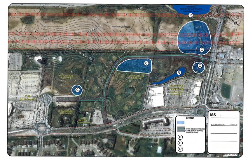
Date Printed: 9/15/2017                                              551-IPPW-ENG SRV-SAN-Ira Needles Boulevard-By-pass
Appendix D –
Stormwater Management
Alternatives
You can also read