Routeburn Track Walking - Walking Access
←
→
Page content transcription
If your browser does not render page correctly, please read the page content below
2/3/2021 Routeburn Track — NZ Walking Access Commission Ara Hīkoi Aotearoa
Routeburn Track
Walking
Dif culties
Medium , Hard
Length
33.3 km
Journey Time
2-4 days
Region
Otago
Sub-Region
Queenstown-Lakes District
Part of the Collection
Department of Conservation Great Walks
Track maintained by
Department of Conservation
https://www.walkingaccess.govt.nz/track/routeburn-track/pdfPreview 1/10
2/3/2021 Routeburn Track — NZ Walking Access Commission Ara Hīkoi Aotearoa
p
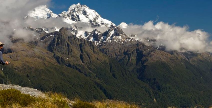
This is the ultimate alpine adventure, weaving through meadows, re ective tarns and alpine
gardens. You'll be rewarded with spectacular vistas over vast mountain ranges and valleys.
Wind through the Routeburn gorge along the crystal-clear Route Burn (river).
Follow the cascade of Routeburn Falls.
Take in spectacular views of the Hollyford valley and Darren Mountains.
Walk right past Earland Falls (174 m).
What to expect
Great Walk tracks are of a higher standard than most other tracks so are well formed and easy to
follow. The tracks are usually quite wide depending on the terrain – some t two people walking
side by side in at areas.
The surface is usually gravel, rock or dirt, and like any track can get slippery in wet weather.
Most rivers and waterways on these tracks have sturdy bridges. Occasionally there are also small
streams that cross the track but are usually easy enough to step across safely. Be aware that in
wet weather rivers can rise very quickly and ood the tracks.
There are hill climbs where the track becomes steeper, which is all the better for views.
Outside the Great Walks season (1 May 2018 - 22 October 2018):
Facilities are greatly reduced and there are additional safety hazards to consider.
Walking the track during this time should only be attempted by t, experienced and well-
equipped people. For more information see Walking the Routeburn Track outside the Great
Walks season (external site) .
Walking options
Walk the full track. Most walkers take 3 days/2 nights usually staying at Lake Mackenzie and
Routeburn Falls huts. The trip can be extended by also staying at the other huts and made into a
circuit by linking with the Greenstone and Caples Tracks , which starts and nishes near the
Routeburn Shelter.
Enjoy a day walk. Earland Falls Track | Key Summit Track Lake Howden Track
| Routeburn Nature Walk
https://www.walkingaccess.govt.nz/track/routeburn-track/pdfPreview 2/102/3/2021 Routeburn Track — NZ Walking Access Commission Ara Hīkoi Aotearoa
Places to stay
There are 4 huts and 2 campsites along the Routeburn Track, which must be booked in advance
during the Great Walks season.
Be aware that huts and campsites can book out many months is advance. Bookings for the
coming summer season usually open in February - exact opening dates will be advised on our
website closer to the time.
Camping outside the designated campsites or staying overnight in the shelters, even when huts
and campsites are fully booked, is not permitted. The track is patrolled by DOC rangers.
Hut facilities
In the Great Walks season these include:
Bunks with mattresses in a communal sleeping layout.
Water supply, ushing toilets, wash basins with cold running water (but no showers).
Heating with fuel available, and usually solar lighting in the main area.
Cooking facilities with fuel, tables and seating (but no cooking utensils).
A resident DOC ranger can tell you about the environment and weather, or help out should
an emergency arise.
Outside the Great Walks season these are reduced:
Gas is not provided - you will need to bring your own cooking stove.
Flush toilets are replaced with pit toilets.
Running water is turned off inside the huts. Water can be obtained from the outside water
tank, if this is frozen, then from the nearest water course or by melting snow.
There are no DOC rangers based at the huts.
Beds are on a rst come, rst served basis only
Campsite facilities
Great Walk campsites are in scenic locations, and usually near huts. You can't use the hut
facilities, but at each campsite you'll nd:
An open cooking shelter.
Water supply tap.
Clean toilet.
A friendly hut warden (from the nearby hut during summer season) who may visit to chat and
check campsite tickets.
https://www.walkingaccess.govt.nz/track/routeburn-track/pdfPreview 3/102/3/2021 Routeburn Track — NZ Walking Access Commission Ara Hīkoi Aotearoa Detailed description The Routeburn Track has two starting and nishing points and may be walked in either direction. One track end is at the Routeburn Shelter (near Glenorchy and 68 km from Queenstown). The other is at The Divide (on the Milford Road, 85 km from Te Anau). Routeburn Shelter to Routeburn Flats Hut Time: 1 hr 30 min – 2 hr 30 min Distance: 7.5 km The track begins at Routeburn Shelter, gently winding alongside the crystal-clear Route Burn (river). After passing Sugarloaf Stream, you’ll climb to Bridal Veil Waterfall and continue above the gorge. A swing bridge leads to open grassed ats, and the Routeburn Flats Hut and Campsite. Routeburn Flats Hut to Routeburn Falls Hut Time: 1 – 1 hr 30 min Distance: 2.3 km The track climbs steadily through stunning beech forest, providing views of the Humboldt Mountains. End the day at Routeburn Falls Hut, on the edge of the bushline and close to the impressive Routeburn Falls cascade. Routeburn Falls Hut to Lake Mackenzie Hut Time: 4 hr 30 min – 6 hr Distance: 11.3 km Climb steadily up the valley, through wetlands and tussock-covered ats, before sidling along the bluffs above Lake Harris to reach the highest point on the track at Harris Saddle/TarahakaWhakatipu (1,255 m). The track then descends and traverses along the exposed Hollyford Face, with expansive views over the Darran Mountains. This section of the track is well-known for its impressive array of alpine plants. A steady descent leads to Lake Mackenzie Hut, set beside the enchanting Lake Mackenzie. Side trip: Conical Hill Time: 1 hr 30 min – 2 hr return https://www.walkingaccess.govt.nz/track/routeburn-track/pdfPreview 4/10
2/3/2021                                Routeburn Track — NZ Walking Access Commission Ara Hīkoi Aotearoa

   A short, steep climb from the Harris Saddle up Conical Hill gives superb views of the Hollyford
   Valley through to Lake McKerrow and beyond to Martins Bay and the Tasman Sea. Be aware that
   snow and ice can sometimes make this trip hazardous early and late into the Great Walks
   season.

   Mackenzie Hut to Howden Hut
   Time: 3 – 4 hr
   Distance: 8.6 km

   Leaving Lake Mackenzie Hut the track crosses a small at before climbing to the bush line. A
   gradual descent then leads past the ‘Orchard’, an open grassy area dotted with ribbonwood
   trees, to the impressive Earland Falls (174 m). The track continues its descent through beech
   forest to Lake Howden Hut.

   Lake Howden Hut to The Divide
   Time: 1 –1 hr 30 min
   Distance: 3.4 km

   The well-graded track climbs steadily for about 15 minutes to the Key Summit Track turn-off.
   From the Key Summit turn-off, the gradual downhill walk is through silver beech forest to The
   Divide on the Milford Highway. At 532 m, The Divide is the lowest crossing of the Southern Alps in
   New Zealand.

   Side trip: Key Summit

   Time: 1 – 1 hr 30 min return

   This popular walk climbs above the bushline to an alpine wetland and, in good weather, offers
   magni cent views of the Darran Mountains and the Hollyford Valley. A self-guided alpine nature
   walk passes a range of native vegetation: beech forest, subalpine shrublands and alpine tarns
   and bogs. Birdlife is proli c and tomtits, robins, New Zealand pigeons/kererū and
   bellbirds/korimako are commonly seen.

https://www.walkingaccess.govt.nz/track/routeburn-track/pdfPreview                                          5/10
2/3/2021                                Routeburn Track — NZ Walking Access Commission Ara Hīkoi Aotearoa

      Conditions:

      Track partially closed

      The Routeburn Track was damaged from ooding in February 2020, however can be walked as
      a 4-day 3-night return experience . Find out more about the partial reopening at Routeburn
      Return      .

      Be prepared - take the right gear

      As with any outdoor experience, the decisions you make and your safety are your
      responsibility.

           Check conditions – check with the DOC Visitor Centre for track conditions and weather
           before your trip.
           Take the right gear for all conditions and enough food. All walkers should take a rst aid
           kit. Get a list of what to take         .
           If walking outside the Great Walks season we recommend you also take a mountain radio
           and/or personal locator beacon. Also see Walking the Routeburn Track outside the Great
           Walks season         .
           Your mobile is not useful as there is no coverage for the Milford and Routeburn Tracks
           and very little on the Kepler Track (limited to high areas).

      Tell someone your plans

      We recommend you tell someone your plans and leave a date to raise the alarm if you
      haven't returned. For how to do this, see the Outdoors Intentions process (external site)             –
      AdventureSmart website.

      Tracks are sometimes closed for safety reasons

      Sometimes the Great Walk tracks need to be closed for safety reasons (eg avalanche danger,
       ooding or high winds). If walkers are not able to proceed, options are available. These may
      include a refund (if walk not started yet), changing direction on the track or transfer across
      hazard areas. DOC staff will keep you informed of all issues and options.

https://www.walkingaccess.govt.nz/track/routeburn-track/pdfPreview                                              6/10
2/3/2021 Routeburn Track — NZ Walking Access Commission Ara Hīkoi Aotearoa
Hazards to look out for on Great Walks
Being lost
The tracks are very well marked but if you become lost you should stop, nd shelter and stay
calm. Put on extra clothing and assist rescuers should you hear them searching for you.
Being injured or ill
If you are injured or become ill, use your rst aid kit immediately and contact DOC staff if
needed. In case of emergency an evacuation may be possible.
Hypothermia (too cold)
During cold, wet and windy conditions, hypothermia (drop in core body temperature) can
become a serious problem. From initial stages to unconsciousness can take as little as 30
minutes.
Wear warm and weatherproof gear and eat regularly during your walk.
These symptoms may indicate initial stages of hypothermia: shivering, clumsy, confused,
have slurred speech, may deny they have a problem.
To treat: immediately make or nd shelter, get the person into dry, warm clothing, put
into sleeping bag, give warm, sweet drinks, monitor and seek immediate medical help.
Heat exhaustion
Heat exhaustion is usually caused by warm temperatures and not drinking enough water.
Carry and drink water regularly throughout your walk.
A person in the early stages of heat exhaustion may show weakness, dizziness, nausea or
vomiting, loss of appetite and sweating.
To help, give them water and nd a cool place to rest.
Fires
Take care to put ashes from hut re places in the metal drums to avoid huts burning down. At
campsites only use the designated areas. No open res are permitted in Fiordland National
Park.
Flooding
During and after heavy rain, ooding of tracks is common on all Great Walks. Stream and river
levels will drop rapidly once rain stops. If you are caught between ooded streams seek
higher ground and wait for water levels to drop.
Risk areas may include:
Kepler Track – Iris Burn Valley.
https://www.walkingaccess.govt.nz/track/routeburn-track/pdfPreview 7/102/3/2021 Routeburn Track — NZ Walking Access Commission Ara Hīkoi Aotearoa
Milford Track – between Hirere and Bus Stop in the Clinton Valley; and between Boat
Shed and Poseidon Creek in the Arthur Valley.
Routeburn Track – Routeburn Valley.
Strong winds
Whenever you are walking in alpine areas or exposed areas on any of the tracks, such as over
passes, saddles and along mountain ridges, you could be caught in strong and/or gusty winds
(eg over 80km/hour winds). Take care to dress warmly as wind-chill danger is worse at these
times.
Avalanches
Snow avalanches are common on all tracks, especially between late August and early
November. Danger is higher during or directly after snow and rain. Avalanche and snow
hazard can change rapidly from low to high within a 24 hour period.
Follow all advice given by staff.
Start zones of avalanche paths often cannot be seen from the track.
In danger areas, do not walk below other walkers.
Risk areas may include:
Kepler Track – 9 avalanche paths cross the track between Luxmore Hut and Hanging
Valley shelter.
Milford Track – over 57 avalanche paths cross the track between 6 Mile in the Clinton
Valley and Quintin Hut in the Arthur Valley.
Routeburn Track – over 32 avalanche paths cross the track between Routeburn Falls hut
and the Earland Falls.
Slips
Routeburn Track – the area halfway between Routeburn Flats and Routeburn Falls Huts is
prone to slips after heavy rain. Care is required when traversing this area. If in doubt, do not
proceed.
Walking the Routeburn Track outside the Great Walks season
Outside the Great Walks season (early May to late October) facilities are greatly reduced (no
gas for cooking, limited water supply, no rangers or emergency radio facilities) and there are
additional safety hazards to consider:
The winter environment in Fiordland is very cold and wet, with ice, snow and short
daylight hours. Avalanche-prone bridges across some major watercourses are removed.
https://www.walkingaccess.govt.nz/track/routeburn-track/pdfPreview 8/102/3/2021 Routeburn Track — NZ Walking Access Commission Ara Hīkoi Aotearoa
DOC does not manage hazards such as ooding or avalanche.
Walking the track at this time should only be attempted by t, experienced and well-
equipped people. For more information see Walking the Routeburn Track outside the Great
Walks season .
Follow the Outdoor safety code - Mountain Safety Council (external site) l
How to get here
One track end is at the Routeburn Shelter (near Glenorchy and 68 km from Queenstown). The
other is at The Divide Shelter (on the Milford Road, 85 km from Te Anau).
Transport operators
Glenorchy Journeys (external site)
Go Orange (external site)
TrackNet (external site)
It's also possible to make a circuit by combining the Routeburn Track with either the Greenstone
and Caples tracks .
https://www.walkingaccess.govt.nz/track/routeburn-track/pdfPreview 9/102/3/2021 Routeburn Track — NZ Walking Access Commission Ara Hīkoi Aotearoa Track Elevation and Map Page last updated: Sep 8, 2020, 3:42 PM https://www.walkingaccess.govt.nz/track/routeburn-track/pdfPreview 10/10
You can also read