Runner Guide! - Aravaipa Running
←
→
Page content transcription
If your browser does not render page correctly, please read the page content below
Runner Guide!

          Welcome to the 2020 Tushars Mountain Runs held in Beaver, Utah and based out of
          the Eagle Point Ski Resort. This is the races fifth year and Aravaipa Running’s third at
             the helm. If you have never had the pleasure of running in these mountains, my
           goodness, you are in for a treat. The farther you make it on these courses, the more
                                               beautiful it gets.

          While this year’s edition will be different due to the COVID guidelines, once you’re out
          on course, the mountains and trails are still there and are the true reason why you’ve
          arrived here in the first place. Stop and take pictures, sit down for a second and enjoy
             the views, and cheer on your fellow competitors. Embrace it all, you’ve got this.
                                              ~ Noah Dougherty
                                                      R.D.

Race Start Times – these will be done in wave starts of up to 20pp in 2020
4:45 AM – 100 Km Start at Eagle Point Resort
6:00 AM – 70 Km Start at Eagle Point Resort
7:00 AM – Marathon Start at Eagle Point Resort
8:00 AM – Half Marathon Start at Eagle Point Resort

Location
Eagle Point Resort – Skyline Lodge
150 S W Village Cir
Beaver, UT 84713
Directions

COVID-19 GUIDELINES

As all of you know and have agreed to during the registration process, you know there will be some
differences in our race this year. These protocols are the best way for all of us to be able to enjoy trail
running in a safe and responsible way. We take these guidelines very seriously and if you are not willing
to fully abide by all the changes then we politely ask that you remain home. Further, if you are at all
feeling unwell, remain home.

    •   All runners will be required to wear a face covering when picking up their race packets, while in
        the race village before and after racing, while utilizing aid stations, and at any other time when
        social distancing is not possible.

    •   Each race will begin as a wave start of no more than 20 people and occurring every five minutes.
        These wave starts will be based on your Ultrasignup score and your run will be chip timed. The
        waves will have social distancing in mind and will be two people per row, six feet apart, until the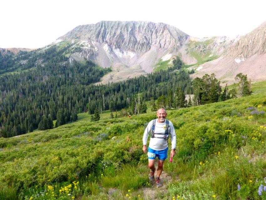
wave is complete. We will build in time gaps between distances to aid in the spread of runners
        on course, and race cutoffs are adjusted accordingly. Wave starts will be posted in advance of
        the race, so you know when you’ll be expected to start your race. See the example at the end of
        this guide.
    •   If you arrive at a remote aid station with multiple people, then you may need to wait to receive
        aid. Please be respectful of this and do not get discouraged or inpatient. Many, if not all, of the
        other runners will experience a similar situation during their race.
    •   Aid station volunteers will hand you food items in the event they are not prepackaged for you
        (hot food for example). They will be able to fill your water bottles and/or bladders but will not
        touch them- you will open and hold them as they pour.
    •   All runners will be subject to a no-touch temperature check just prior to being allowed into the
        starting corral to begin your race wave. Anyone who has a temperature of 100.4 or greater will
        be asked to remove themselves from the race and depart the property.
    •   Please refrain from the typical hugging, high fiving, etc. that some of us love about our
        community.
    •   Respect the guidelines and everyone around you. While you may not be very worried, the
        runner next to you may be concerned.

Race Day Schedule
Please arrive early to park, check in and warm up prior to your run. Restroom facilities are located at the
start line at a permanent park facility.
Reminder: All runners will be subject to a “no touch” temperature check prior to entering their starting
corral with the assigned wave. This takes just seconds to complete.

Timeline
4:15 AM – Packet pickup / race day registration begin
4:45 AM – 100 Km Start (waves up to 20 runners every 5 minutes)
6:00 AM – 70 Km Start (waves up to 20 runners every 5 minutes)
6:05 AM – Begin Civil Twilight
6:34 AM – Sunrise
7:00 AM – Marathon Start (waves up to 20 runners every 5 minutes)
8:00 AM – 1/2 Marathon Start (waves up to 20 runners every 5 minutes)
8:39 PM – Sunset
9:08 PM – End Civil Twilight

5:00 AM – 100 Km final cut-off / Race ends

Moon Phase – Last Quarter 95%
Moonrise: 3:30 PM
Moonset: 4:47 AM

Parking
There is ample parking near the Skyline Lodge where the start and finish line are located. Overflow
parking can be found closer to the Canyonside Lodge. Please arrive early to ensure you are on time.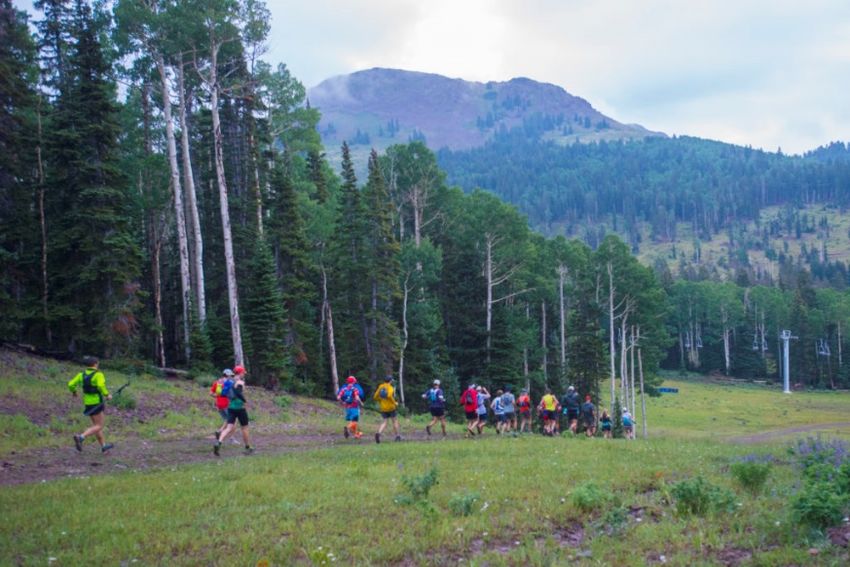
Trail Running & Trash
Help be a steward of the trails. Please respect the trails and the beauty of these mountains by disposing
of any trash at one of our aid stations.

Reminder: Cupless Events

A reusable cup is required to run the Tushar Mountain Runs.

In an effort to continually lessen our race footprint, we are continuing our cupless events to the Tushars
Mountain Runs. We will have UltrAspire reusable cups available at registration and on race day or feel
free to bring your own! To check them out or purchase one directly visit our website HERE.

COVID Update: We will be offering no touch water dispensing options, prepackaged food items, and our
volunteers will be handing food to the runners in most other cases. If you have a bladder or soft flask,
our volunteers can still fill them but you have to open and hold them as they pour the water from a
pitcher.

Trail Etiquette
Social Distance throughout your entire time at this race
Remember to always remain on designed trails, no short cutting.
If you decide to use headphones, please be respectful of runners behind you attempting to pass. Also,
remove ear buds as you approach aid stations or a road crossing.
This course includes some legit single track. If you are fast and attempting to pass, please alert the
runner in front of you before flying past them. Likewise, if you hear a runner approaching you from
behind, attempt to find a spot to allow the runner to pass.

As a general rule, when passing a runner, announce, “on your left.”
Uphill runners/hikers have the right of way to downhill runners. Remain in control as you descend and
respect the other runners.
Everyone is after the same goal here so let’s be respectful of each other’s races and have fun. Please.

Race Timing
We will be utilizing a chip timing system at this event to record your time at the finish. You will be
provided with a timing chip attached to the back side of your race bib. It is important to not crease, or
fold the timing chip to ensure your finish time is read. We will also have a limited number of remote
timing points on course that should allow crews and family to better track your progress during the race.
Visit www.aravaiparunning.com/results and click on “Live Results” to follow along. NOTE: This course is
very remote and it is quite possible that the online timing points will not post immediately or at all
during the race. Thank you for your patience.

Drops

Don’t drop. Seriously, you’re stronger than you give yourself credit for and you can keep going.
However, we also understand that things happen that say otherwise. You MUST inform an aid station
captain before leaving the course so that we are not waiting for you to arrive at the next aid station.
Further, given the remoteness of this course, if you find yourself in a position where you want to quit at
Miner’s Park or Alunite Ridge, this is your warning that it could take upwards of one and a half hours to
retrieve you plus that amount of time to return to the finish line. Take a few minutes to gather yourself.
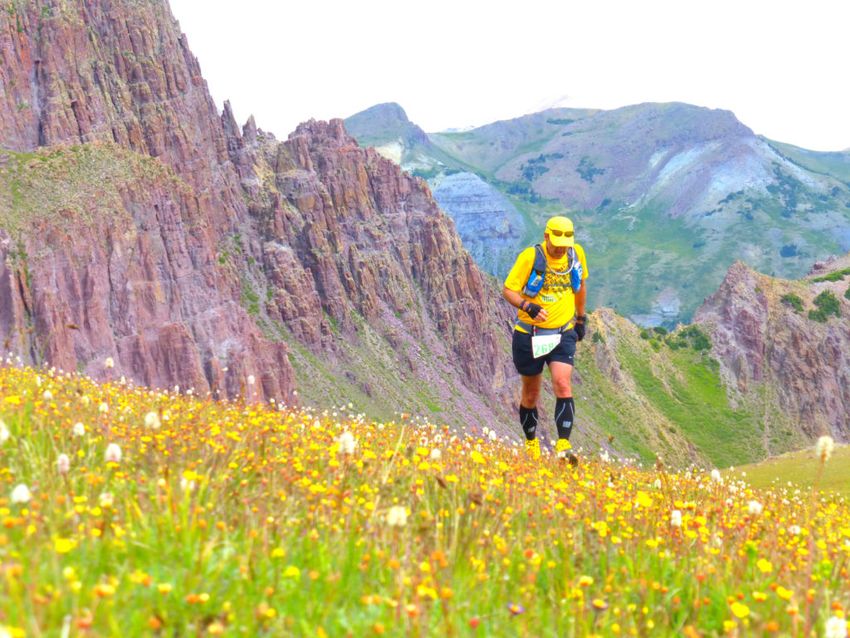
Try to eat and drink something and reconsider. Keep Going.
COVID Update: Face coverings will be required if you hop into a staff vehicle to be pulled from the
course and we will not be able to pack the vehicle with runners which could mean an even longer wait at
an aid station.

Course Summary (Pulled directly from Website)

100 Km
The 100K begins by climbing out of the ski resort (10,500 ft) and links into some pristine single track at
the base of Mt. Holly. The trail skirts around the side of the mountain and around mile four peers off a
high point along the ridge into the backside of Mt. Delano. After dropping down into and traversing a
vast valley, you’ll climb up to the Alunite Ridge Aid Station, located near some old mining ruins around
mile 8. When the trail peaks out the top of the ridge at 11,400 ft, you’ll be rewarded with a view of
several more peaks, including Copper Belt Peak, which you’ll climb later in the day.

You’ll then drop down into the south side of the rugged Bullion Canyon, made famous by a mining
community which transformed the canyon into one of the “wildest and wooliest places on earth.” Over
the next 4 miles, the singletrack will take you by abandoned mine shafts and cabins that leave one
wondering how they got their equipment into these areas and how they survived in this steep,
unforgiving country.

After a 2,000 ft climb, you’ll reach the summit of Mt. Delano, the high point of the course, and then
descend nearly the same distance before hitting the doubletrack that you’ll follow downhill for less than
a mile down to Skyline aid station at mile 15.5. You’ll then descend another mile down to a trailhead and
climb 5 miles of singletrack up to Mud Lake aid station at mile 21.5. After a quick out-and-back to the aid
station, you’ll climb over a pass that opens up views of the towering Mt. Baldy and Mt. Belknap. You’ll
descend 5 miles and 2,000 ft to the aptly named Blue Lake, followed by a 2,000 ft climb on a forest
service access road to the Bullion Pasture Aid Station at mile 28.5.

From here, you’ll descend the famous Paiute ATV trail 3 miles and 1,500+ feet down to the Copper Belt
Peak Aid Station at mile 31.5 where you’ll check in and continue on to tackle Copper Belt Peak. After
summiting and returning to the aid station at mile 38, you’ll climb back up to the Bullion Pasture Aid
Station at mile 41 and then will drop down Bullion Canyon, descending nearly 4,000 ft to the Miner’s
Park aid station and passing by the gorgeous Bullion Falls en route.

From just past the mining ruins at mile 48, you’ll climb back up the 4,000 ft that you just lost, this time
on the south side of the canyon, all the way up to Edna Peak just before reaching the Alunite Ridge Aid
Station to complete the loop at mile 55 and then will return to the starting line.
70 Km
The 100K begins by climbing out of the ski resort (10,500 ft) and links into some pristine singletrack at
the base of Mt. Holly. The trail skirts around the side of the mountain and around mile four peers off a
high point along the ridge into the backside of Mt. Delano. After dropping down into and traversing a
vast valley, you’ll climb up to the Alunite Ridge Aid Station, located near some old mining ruins around
mile 8. When the trail peaks out the top of the ridge at 11,400 ft, you’ll be rewarded with a view of
several more peaks, including Copper Belt Peak to the North.

You’ll then drop down into the south side of the rugged Bullion Canyon, made famous by a mining
community which transformed the canyon into one of the “wildest and wooliest places on earth.” Over
the next 4 miles, the singletrack will take you by abandoned mine shafts and cabins that leave one
wondering how they got their equipment into these areas and how they survived in this steep,
unforgiving country.

After a 2,000 ft climb, you’ll reach the summit of Mt. Delano, the high point of the course, and then
descend nearly the same distance. At the double track road, depart the 100K course and head right up
to the Mud Lake aid station. Continue on re-joining the 100K route and you’ll climb over a pass that
opens up views of the towering Mt. Baldy and Mt. Belknap. You’ll descend 5 miles and 2,000 ft to the
aptly named Blue Lake, followed by a 2,000 ft climb on a forest service access road to the Bullion
Pasture Aid Station.

After Bullion Pasture, you will drop down Bullion Canyon, descending nearly 4,000 ft to the Miner’s Park
aid station and passing by the gorgeous Bullion Falls en route.

From just past the mining ruins, you’ll climb back up the 4,000 ft that you just lost, this time on the
south side of the canyon, all the way up to Edna Peak just before reaching the Alunite Ridge Aid Station
to complete the loop and then will return to the starting line.
Marathon

The trail marathon will follow the same route as the 100K & 70K runners over the top of Delano and
then make a right turn at the double track road (same as 70K) leading to Mud Lake Aid Station at mile
16. Shortly after this aid station, you’ll turn left at a signed junction (very important- 100K & 70K will go
right towards Bullion, please do not do that) and run about 6.7 miles to reach your final aid, the Skyline
Trail Aid Station. Now, enjoy the last 4 miles running at the western foot of Mt. Delano and Mt. Holly
before reaching the finish line.

Half Marathon

The half marathon takes the Skyline trail to the Skyline Trail Aid Station, then does an out-and-back
climb up to the summit of Mt. Delano at 12,170 ft. It then returns the way they came to the finish line.
Required Gear List: 100K, 70K, and Marathon
Given that this is a true mountain race in the middle of the summer, we are instilling a mandatory gear
list that consists of:

Emergency/Space Blanket
Rain Jacket
Cell Phone/ GPS Device*
Whistle
Reusable Cup

You will not be able to pick up your race packet (race bib) until you have shown us these items so please
bring them with you to packet pickup or on race morning.

*Our intent here is to have all participants running with their course on their phone and/or a GPS device
such as a watch. We will mark the course as well as we can but over the last two years we have seen
wildlife and cattle eat or trample our ribbons and pin flags. Having the track on you at all times can be
an important piece of mind if you come to spot on course where you’re unsure of where to go.
Example for phone: Gaia app (free, works in airplane mode)
If you are using your watch for a GPS track, we highly recommend also carrying a phone in case of an
emergency.

Weather
This race can have anything from sunny skies to thunderstorms, hail storms and cold, foggy, and windy
summits- all in one afternoon. Please come prepared for all of these! Typical temperatures range from a
low in the 40’s to highs touching the 90’s. Forecast for Eagle Point Resort, UT

Bib/Shirt Pickup

Friday, July 31
4:00-7:00 PM at the Eagle Point Ski Resort Yurt (Start/Finish Line)
A pasta dinner will be provided by the Eagle Point Resort staff. The resort will also be making food on
Saturday (either a taco style bar or grilling food, tbd still) for your post-race meal. You may purchase a
meal ticket for $7 during the registration process or directly HERE. Food will be $10/meal at the resort.

If you paid for a meal during the registration process, you will receive a ticket when you pick up your
race packet. Hand the ticket to the cashier in the lodge and you will be able to get your meal.
Please be sure to practice social distancing and wear a mask when not eating in the lodge.

8:00 PM – 100K and 70K drop bag cut off (they need to be dropped off before this time to allow us time
to distribute them to Bullion Aid Station)

Eagle Point Ski Resort
150 S W Village Cir
Beaver, UT 84713
Directions
Saturday, August 1
4:15-8:30 AM at the Eagle Point Ski Resort -Skyline Lodge (Start/Finish)

Eagle Point Resort -Skyline Lodge
1040 N Elk Meadows Dr.
Beaver, UT 84713
Directions

Aid Stations
Aid stations every 3.0 to 8.0 miles including water, electrolyte drink, sweet snacks, salty snacks, and
fruit. Please plan to run with at least two bottles of water. As the miles increase, our aid stations will
include more substantial food such as grilled cheese, quesadillas, ramen and/or soup.

100K & 70K: From Bullion Aid you will drop 4,000+ feet to Miner’s Park, the low point on the course,
where you will then climb 4,000+ feet up Mt Edna. This is a great place to utilize your drop bag and plan
to take additional water bottles or a pack from Bullion on.

Race Perks
Gender specific cut race shirt
Chip timed race results displayed at finish line
Scenic and challenging course
Well stocked aid stations every 4.0 to 8.0 miles
Post race food & socializing
100K Custom Wood Finisher award
70K, Marathon & ½ marathon: Tushars engraved stainless steel pint cup finisher award

Crews & Pacers
Crew Driving Directions

Crews are welcome to support runners at the finish line at the Skyline Lodge at the start/finish as well as
the selected aid stations listed below. Crews are asked to follow social distancing rules throughout their
time on site and minimize all crowding near an aid station.

Runners are allowed one (1) crew vehicle and will be supplied with a crew pass that must remain in the
vehicle at all times. If a second vehicle is found on course at one of these aid stations, the runner can be
penalized or disqualified.

Mud Lake
Bullion Pasture
Miner’s Park

There is limited parking at all three of these locations and under no circumstances may you park ON
FS123 or the road to Miner’s Park if you are blocking a lane and impeding traffic. For both Bullion and
Miner’s, there are small lots that crews may park at about ¼ mile before reaching the aid. For 2020, we
are allowing runners to receive aid in these areas rather than just at the aid station.

*No crews allowed for the marathon or 1/2 marathon distances.
*Practicing social distancing is a must

*There is very limited parking at all of these locations and is critical that a right-of-way always remains
for emergency vehicle access*

Mud Lake – this aid station is placed just off the forest road in a field where the runners return to single
track. There is limited parking here and if there is bad weather, there will be even less parking as it is
essentially just a small field and can get muddy. Vehicle: 4×4 or high clearance recommended as it can
be rocky and includes at least one small stream crossing (3-5 feet wide, shallow) and some hairpin turns.

Bullion Pasture– crews will need to park in an open area on the left side of the road about 200 yards
before Bullion Pasture aid and walk up. For 2020 only, given our current circumstances with COVID, you
will be allowed to give aid to your runner in this lot. Vehicle: 4×4 or high clearance recommended as it
can be rocky and includes at least one small stream crossing (3-5 feet wide, shallow) and some hairpin
turns.
Of note: in the event there is rain/inclement weather race week and/or on race day, we will likely close
Bullion Pasture Aid to crews as the pass between Mud Lake and Bullion is not safe. However, if you are
still interested in crewing or pacing from Bullion, you can park at Mud Lake and hike the 3 miles to
Bullion on the road.

Miner’s Park– crews will need to park in the small lot at “Miner’s Park” interpretive area on the right
hand side and walk the 1/4 mile up to the aid station. Again, given the current climate with COVID, you
are allowed to give aid to your runner in this parking lot. Miner’s aid is about 1 hour 10 minutes beyond
Bullion Pasture aid station continuing on FS123 & 1 hour 50 minutes from the start line, driving through
Marysvale.

Pacers
Pacers are allowed for the 70K and 100K distances starting at Bullion Pasture (Mile 41 for 100K runners)
or Miner’s Park. One pacer per runner on course and pacers are responsible for their own transportation
to/from these aid stations.

Rain/Inclement Weather Crew & Pacer Plan
In the event that there is rain in the forecast or rains have had an adverse impact on the roads, crews
will be advised to only access these aid stations:
Mud Lake – This will become VERY limited in parking if it has been/is raining.
Miner’s Park – driving around the mountains, not over the pass (see directions)

The drive up and over the pass from Mud Lake to Bullion is sketchy to say the least in wet weather
conditions. If walking/running is an option for you, it is around 2.8 beautiful miles one way from Mud
Lake to Bullion on the forest service road.

Similarly, for pacers looking to join their runner at bullion Pasture II, you can do so by hiking over the
pass 3 miles and joining your runner. Access to Miner’s Park will still be an option to pick up or drop off a
pacer.
Drop Bags
A drop bag will be allowed at the Bullion Pasture Aid station for 100K & 70K runners. 100K runners will
hit this aid station twice (mile 28.5 & 41). Please have your drop bag with you on Friday evening at
packet pickup before 8 PM to be collected and delivered on time. They will be transported to the finish
line after the Bullion Pasture Aid Station closes down around 9:00 PM. Your drop bags will remain at the
finish line until around 10-11am on Sunday. After, they will be transported to our Phoenix office and be
available to be shipped to you if necessary.

Cut-Offs: You must be LEAVING the aid by these times.
Cutoffs have been adjusted to correspond with the wave starts
100Km
1:30 PM: Mud Lake Aid Station ~ Mile 22
4:00 PM: Bullion Pasture Aid Station Mile 28.5
5:00 PM: Copper Belt (1) Aid Station ~ Mile 31.5
7:15 PM: Copper Belt (2) Aid Station ~ Mile 38.6
8:30 PM: Bullion Pasture Aid Station Mile 41.3
11:00 PM: Miner’s Park Aid Station ~ Mile 48.2
3:00 AM: Alunite Ridge Aid Station ~ Mile 53.7
5:30 AM: Finish ~ Mile 62

70K
2:00 PM: Mud Lake Aid Station ~ Mile 16
8:00 PM: Bullion Pasture Aid Station ~ Mile 22.8
10:30 PM: Miner’s Park Aid Station ~ Mile 29.7
2:30 AM: Alunite Ridge Aid Station ~ Mile 35.2
5:00 AM: Finish ~ Mile 43.2

Marathon
3:30 PM: Mud Lake ~ Mile 16.5
7:00 PM: Skyline ~ Mile 22.3
9:00 PM: Finish ~ Mile 26.6

Half Marathon
7:00 PM: Skyline ~ Mile 9.2
9:00 PM: Finish ~ Mile 13.1
2020 Wave Start Schedule (next page)
You can also read