RYBURGH NEIGHBOURHOOD PLAN (2019-36) - MADE VERSION JUNE 2021 - North Norfolk ...
←
→
Page content transcription
If your browser does not render page correctly, please read the page content below
2021

RYBURGH NEIGHBOURHOOD PLAN (2019-36)
MADE VERSION

                               JUNE 2021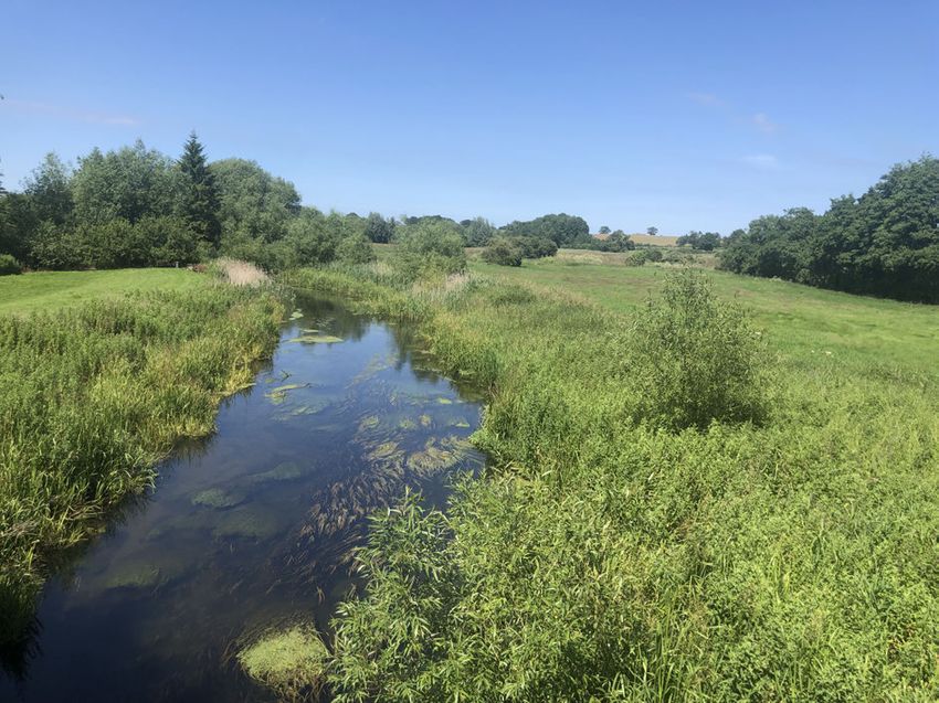
Prepared by Ryburgh Neighbourhood Plan Working Group
on behalf of Ryburgh Parish Council

ryburghndp@gmail.com
www.ryburghpc.info/neighbourhood-plan
www.north-norfolk.gov.uk/ryburghnp

All documents can be made available in
Braille, audio, large print or in other languages.
Please contact 01263 516318 to discuss your requirements.
Ryburgh Neighbourhood Plan (Made Version)

                                                                                Contents
Contents
1 Introduction                                                                                    3
   1.1   About the Neighbourhood Plan                                                             3
   1.2   Summary of the Neighbourhood Plan Process                                                3
   1.3   Constraints                                                                              5
   1.4   The Emerging North Norfolk Local Plan                                                    5
   1.5   Planning Policies vs Community Aspirations                                               6
   1.6   Timeframe of the Neighbourhood Plan                                                      6
2 The Neighbourhood Area                                                                          7
   2.1   Profile of Ryburgh Neighbourhood Area                                                    7
3 Informing the Neighbourhood Plan                                                                9
   3.1   Aims                                                                                     9
   3.2   Vision Statement                                                                         9
4 Planning Policies                                                                              11
   4.1   Traffic Safety                                                                          11
   4.2   Footpaths / Cycleways; Access to the Countryside                                        12
   4.3   New Housing                                                                             13
   4.4   Protection of the Landscape                                                             15
   4.5   Protection of the Environment                                                           16
   4.6   Protection of the Historic Environment                                                  18

Annexes
1 Neighbourhood Area Map                                                                         19
2 Consultation Process                                                                           21
3 Memorandum of Aspirations                                                                      23
4 Land Safeguarded for Public Access Map                                                         25
5 Settlement Boundary Map                                                                        27
6 European Sites Map                                                                             29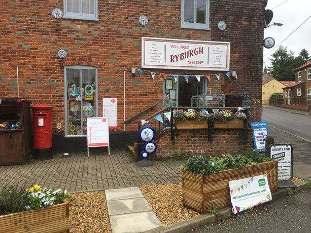
Ryburgh Neighbourhood Plan (Made Version)

 Contents
Ryburgh Neighbourhood Plan (Made Version)   3

                                                                                             Introduction 1
1 Introduction
1.1 About the Neighbourhood Plan
1.1.1 This Neighbourhood Development Plan (NDP) was prepared by a sub-committee of Ryburgh
      Parish Council following its inception in December 2016. This Steering Group had the objective
      of producing a document to be taken into account in deciding planning applications for
      development in the Ryburgh Neighbourhood Area (RNA) for a period of 20 years. The extent
      of the RNA is shown in 'Annex 1 - Neighbourhood Area Map'.

1.1.2 The process to prepare the NDP included consultation with North Norfolk District Council
      (NNDC), statutory bodies, residents and persons working in the Neighbourhood Area, and the
      preparation and submission of a number of supporting documents ahead of independent
      examination and public referendum.

1.1.3 Following examination, and a public referendum, this Neighbourhood Plan came into effect
      as a material consideration in the planning process on 7 June, 2021.

1.1.4 The following section provides a summary of the process undertaken to prepare the Plan.

1.2 Summary of the Neighbourhood Plan Process
Early Engagement

1.2.1 The process of plan making and engagement is almost as important as the Plan itself.
      Consultation was carried out throughout the Plan process and was required to demonstrate
      that the policies in the NDP were informed by participation of the people who live, work and
      have business interests in the Neighbourhood Area. Consequently, a range of early engagement
      was undertaken and this is outlined in Annex 2 'Consultation Process'and in the
      submitted Consultation Statement.

Pre-Submission Stage Consultation

1.2.2 The first draft of the NDP was published for a six-week period of consultation between 12
      August and 23 September 2019, in line with Regulation 14 of the Neighbourhood Planning
                                                  (1)
      General Regulations 2012 (as amended) . This provided those who live, work and have
      business interests in the Neighbourhood Area with the opportunity to see the emerging Plan
      in its first full form. A number of responses to the consultation were received and details of
      these along with the changes made to the Plan as a result are set out in the Consultation
      Statement.

Submission Stage & Consultation

1.2.3 The Submission Version of the NDP represented Ryburgh Parish Council’s final proposed
      Neighbourhood Plan document. It was submitted to North Norfolk District Council (NNDC) on
      16 March 2020 in line with Regulation 15 of the Neighbourhood Planning General Regulations
      2012 (as amended) along with a number of other prescribed documents:

             Basic Conditions Statement
                                                                                                 (2)
             The purpose of this document was to set out how the RNP met the Basic Conditions
             test which must be applied by appointed examiners when inspecting submission version
             plans. This considered whether the Ryburgh NDP, as submitted, was in general conformity

1   http://www.legislation.gov.uk/all?title=Neighbourhood%20Planning%20Regulations
2   https://www.gov.uk/guidance/neighbourhood-planning--2#basic-conditions-for-neighbourhood-plan-to-referendum
4       Ryburgh Neighbourhood Plan (Made Version)

        1 Introduction
                     with local and national planning policy, and did not breach EU law or other basic conditions
                     (3)
                        applying at the time.
                     Consultation Statement
                     The purpose of this document was to set out how Ryburgh Parish Council &
                     Neighbourhood Plan Steering Group engaged with the community in preparing the Plan.
                     The focus of the ‘Consultation Statement’ is on the 6-week Regulation 14 Pre-submission
                     stage consultation. However, it also includes a summary of previous community
                     engagement and consultation that was undertaken and how it was used to inform
                     amendments to the Plan.
                                                           (4)
                     Other evidence base documents

    1.2.4 NNDC published the Submission Version NDP for a 6-week period of public consultation in
          accordance with Regulation 16 of the Neighbourhood Planning General Regulations 2012 (as
          amended). The consultation took place between Monday 6 April and Monday 18 May, 2020.
          In light of the global Coronavirus pandemic, and in response to social distancing measures
          imposed, and the shielding of members of the public, the consultation period was extended
          by a further three weeks until Monday 8 June 2020.

    Independent Examination

    1.2.5 An independent examiner was appointed by NNDC to carry out an examination of the
          Submission Version NDP. The examination commenced on Monday 29 June and concluded
          with the submission of the examiners final report, submitted 4 August, 2020. The examination
          was conducted by a process of written representations and did not involve a public hearing.

    1.2.6 The Submission Version NDP and accompanying statements, evidence base and
          representations received during the Regulation 16 consultation were forwarded to the examiner
          and published at www.north-norfolk.gov.uk/ryburghnp. The full list of information and evidence
          considered by the examiner is detailed in the examiner's report.

    Examiners Report

    1.2.7 The examiner issued his independent report to NNDC on Tuesday 4 August, 2020. The report
          recommended that the Ryburgh Neighbourhood Development Plan for the period up to 2036
          should, subject to the specified modifications (those contained in the report), be submitted
          for referendum. Consequently, a 'Referendum Version' of the Plan was prepared which
          incorporated the examiner's modifications, and any necessary consequential changes.

    Decision

    1.2.8 It is the responsibility of NNDC as the Local Planning Authority to determine ia Neighbourhood
          Plan meets the Basic Conditions tests, with or without modifications, and whether it should
          proceed to referendum.

    1.2.9 Under the regulations (Town & Country Planning Act section 4b and Neighbourhood Planning
          Regulations, 2012 (as amended)), officers considered the recommendations made in the
          Examiners Report, and the reasons for them, and were satisfied that the Plan, incorporating
          the proposed modifications in full, could proceed to referendum. A Decision Statement to this
          effect was issued on 2 September 2020, as required by the regulations.

    1.2.10 Regulations linked to the Coronavirus Act 2020 meant that no elections or referendums could
           take place until 6 May 2021. This included neighbourhood planning referendums. In the
           intervening period the National Planning Practice Guidance stated that:

    3       https://www.gov.uk/guidance/neighbourhood-planning--2#Other-basic-conditions-neighbourhood-plan
    4       www.north-norfolk.gov.uk/ryburghnp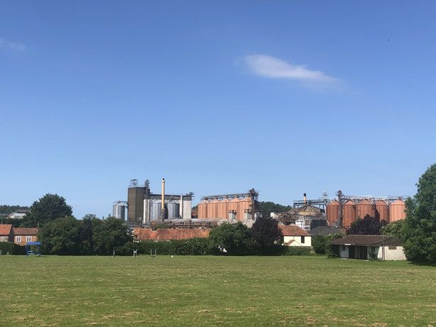
Ryburgh Neighbourhood Plan (Made Version)   5

                                                                                            Introduction 1
             Decision-making: Where the local planning authority has issued a decision statement
             (as set out under Regulation 18 of the Neighbourhood Planning (General) Regulations
             2012) detailing its intention to send a neighbourhood plan to referendum, that plan can
             be given significant weight in decision-making, so far as the plan is material to the
             application.
             Paragraph: 107 Reference ID: 41-107-20200513 Revision Date 13.5.2020

1.2.11 Consequently, significant weight was given to the Referendum Version NDP in decision-making,
       pending the outcome of a future referendum.

The Referendum

1.2.12 A referendum on whether to approve the Ryburgh Neighbourhood Plan took place at Great
       Ryburgh Memorial Hall on Thursday 6 May, 2021.

1.2.13 People residing in the Ryburgh Neighbourhood Area who were registered to vote on the
       electoral register at the time were entitled to vote at the referendum.

1.2.14 At the referendum a specific question was asked of the local community:

             Do you want North Norfolk District Council to use the Neighbourhood Plan for
             Ryburgh Neighbourhood Area to help it decide planning applications in the
             Neighbourhood Area?

1.2.15 The Neighbourhood Plan successfully passed the Referendum stage with a clear majority of
       more than 50% of those voting answering ‘yes’ to the Referendum question.

Made Plan

1.2.16 In accordance with Regulation 19 of the Neighbourhood Planning Regulations 2012 (as
       amended), North Norfolk District Council issued a Decision Statement on 7 June 2021. The
       Ryburgh Neighbourhood Plan took full effect from this date as part of the Development Plan
       for North Norfolk, alongside the North Norfolk Local Plan and National Planning Policy. This
       NDP is a material consideration in the determination of current and future planning applications
       in the Ryburgh Neighbourhood Area.

1.3 Constraints
1.3.1 This NDP is a formal planning document. It puts in place planning policy for the RNA inspired
      by the priorities identified by the community in the consultation process. It does not address
      non-planning issues. It complements and adds local distinctiveness in addition to having regard
                                                                                           (5)
      to the planning policy contained in the National Planning Policy Framework (NPPF) and the
                 (6)
      Local Plan . This NDP contains policies that reflect local circumstances and requirements
      and are justified and evidenced. The policies are intended to be positive and aspirational but
      realistic.

1.4 The Emerging North Norfolk Local Plan
1.4.1 The current NNDC Local Plan (Local Development Framework) will be replaced by the emerging
                              (7)
      North Norfolk Local Plan . Consultation upon the emerging Local Plan commenced in May

5    NPPF, Ministry of Housing, Communities & Local Government, Published 27 March 2012. Last updated 19 June 2019.
     https://www.gov.uk/government/publications/national-planning-policy-framework--2
6    Core Strategy (2008) & Site Allocations Plan (2011), www.north-norfolk.gov.uk/ldf
7    Emerging North Norfolk Local Plan, www.north-norfolk.gov.uk/localplan
6       Ryburgh Neighbourhood Plan (Made Version)

        1 Introduction
              2019 and adoption is currently anticipated in 2022. The emerging Local Plan is intended to
              take effect until 2036. This NDP was prepared so as to reflect and correspond with the
              provisions of the first draft of the emerging Local Plan.

    1.5 Planning Policies vs Community Aspirations
    1.5.1 The consultation process with the community, up to the time of submission of the Plan for
                                                                                       (8)
          independent examination, is detailed in Annex 2 'Consultation Process' . Much of the
          suggestions and comments received from the community during the consultation process for
          this NDP concerned matters that cannot be dealt with through the planning procedure.
          Nevertheless they are of concern and value to the Parish Council. They are the subject of a
          Memorandum (separate to this NDP) to the Parish Council, for action by the Parish Council,
          and are not addressed in this document. They are referred to in this document as “Aspirations”.
          A copy of the memorandum is shown in Annex 3 'Memorandum of Aspirations'.

    1.6 Timeframe of the Neighbourhood Plan
    1.6.1 The policies contained in this Neighbourhood Plan will be applicable for the period ending
          2036 and on a date aligned with the emerging North Norfolk Local Plan.

    8       A separate, detailed Consultation Statement was prepared and submitted for examination, see www.north-norfolk.gov.uk/ryburghnp
Ryburgh Neighbourhood Plan (Made Version)   7

                                                   The Neighbourhood Area 2
2 The Neighbourhood Area
2.1 Profile of Ryburgh Neighbourhood Area
2.1.1 The extent of the Neighbourhood Area is identical to the area of the Ryburgh Parish Boundary.
      The Parish consists of two adjoining settlements: Great Ryburgh and Little Ryburgh. From the
      2011 census Ryburgh is shown as having a population of 694 persons in 264 households. Of
      these 246 are situated in Great Ryburgh and 18 in Little Ryburgh. Little Ryburgh is a hamlet
      collected around a single-track lane, approximately a mile to the north of Great Ryburgh.

2.1.2 Both Great and Little Ryburgh are historic settlements, originally arising from a crossing of the
      River Wensum. Today, the bridge into the village at the original Saxon river crossing point is
      the entrance to Great Ryburgh and carries the C355 that links the A1067 at one end of the
      village to the B1146, at the other end. The C355 is the high street of Great Ryburgh and the
      village has extended by mainly ribbon development on either side of the road to its present
      extent of some 1,500 meters of housing amongst which, adjoining the site of the now dismantled
      railway station and in the centre of the village, is the Crisp Maltings. This is one of the largest
      single industrial sites in North Norfolk and has a major impact on the village, especially in
      terms of the heavy goods vehicles moving to and from the works, as well as in visual terms
      (herein referred to as “the Industrial Site”). The extent and position of the Industrial Site is
      shown in 'Annex 4 - Land Safeguarded for Public Access'.

2.1.3 Crisp Maltings has declared its intention to expand its business at its Great Ryburgh site. A
      public consultation upon proposals for a new access road to the Industrial Site, new malting
      facilities, including the expansion of warehousing/silo storage and a residential development
      of 50-75 houses, took place in July 2017. A trio of planning applications were submitted in
      March 2020 relating to the construction of new grain silos and a warehouse, a new 7.3 metre
      2-way HGV private access road, and associated new buildings and structures required to
      increase the maximum output tonnage of malt in any one calendar year from 115,000 to
      175,000 tonnes. In addition up to 50 new homes were proposed as enabling development
      along with associated amenities and infrastructure including garages and vehicular parking,
      provision of vehicular access onto Fakenham Road, creation of public open space and erection
      of a new community centre. Public consultation on the proposals took place between 17 April
      and 30 June 2020. At the time of submission of this Plan the applications had not been
      determined.

2.1.4 “Planning” is concerned with the use of land, balancing economic development with
      environmental quality. Environmental quality, for the residents of Great Ryburgh has been
      and is being damaged by heavy goods traffic, factory noise and emissions, light pollution and
      visual impact upon the landscape. Crisp Maltings seeks that the village be reclassified from
      its existing designation as open countryside (which is also its intended designation in the
      emerging Local Plan) to a new designation of between a small and large growth village. This
      was not supported by the residents during consultation for this Plan, as such a reclassification
      would be contrary to the environmental quality of the settlement and to the sensitive landscape
      in which it sits.

2.1.5 The policies of this Plan are intended to enable sustainable growth and development of the
      village, including the Maltings, whilst preventing any deterioration of the environment or amenity
      value of the village caused by development of any sort. Accordingly, Policy 1 is intended to
      address the problem of Traffic Safety for the future. The top priority of the residents of the
      village is to see less HGV traffic passing through the village high street and there is general
      support for the building of the new road to the Industrial Site in order to achieve this.

2.1.6 There is also support for the continued growth of housing in the village through the process
8    Ryburgh Neighbourhood Plan (Made Version)

     2 The Neighbourhood Area
            of Infill Housing (see Policy 3) but the proposal to build 50-75 new houses on one site is
            regarded as out of scale to the existing community and likely to be out of character with the
            existing village construction, which has happened piecemeal, could not be accommodated
            within existing infrastructure, and is not supported.

    2.1.7 Ryburgh as a whole is an active community with a community shop, an Inn/restaurant, butcher,
          fish and chip shop, a medieval church with Saxon origins and a round tower, a Village Hall
          and a number of home-based small businesses. Both Great and Little Ryburgh are set within
          the Wensum River valley surrounded by agricultural land and woodlands the great majority
          of which is owned by the Sennowe Estate. The importance to Ryburgh of its setting within the
          river valley cannot be overstated. The meadows, marsh land, lakes, reed beds, hedges and
          ditches provide an open landscape where the river crosses the Neighbourhood Area that is,
          arguably, of great natural beauty and which provides the pre-eminent wildlife corridor (in
          contrast to the intensive agriculture that surrounds it) of North Norfolk.

    Picture 1 Village Field with Crisp MaltingsPicture 2 The Village Shop, a Community Picture 3 Great Ryburgh Memorial Hall,
           in Background (July 2019)                  Interest Company est 2009                 Built 1952 (July 2019)
Ryburgh Neighbourhood Plan (Made Version) 9
Informing the Neighbourhood Plan 3
3 Informing the Neighbourhood Plan
3.0.1 The Vision Statement referred to in Section 3.2 was informed by and developed with the local
community through the consultation process. It forms the foundation of the Ryburgh NDP.
3.1 Aims
3.1.1 The Aims addressed by this NDP which were identified in the consultation process are:
Traffic Safety (this was the most frequently mentioned issue in responses from the
community, in 63.41% of responses). It arises no doubt because of the narrow character
of the high street of Great Ryburgh (namely Station Road/Fakenham Road), the
consequent inadequacy of the pavements and the dangerous proximity to the traffic,
particularly HGV’s, of the pedestrian, of school children catching school buses, of cyclists
and disability scooters. The problem is largely one for the County Highways department
but is the subject of a policy in this NDP designed to ensure that the current position does
not get worse. The issue is also addressed in Annex 3 'Memorandum of Aspirations'.
Footpaths, cycle ways and access to the countryside (53% of responses). It is a
concern of the local community that there is no footpath to the A1067 bus stop serving
the village and that walking the road to and from the bus stop is dangerous. It is also a
concern that there is inadequate access to the local countryside. The creation of footpaths
is not possible through an NDP but a policy has been included to ensure that development
does not take place on the undeveloped portion of the disused railway line. This issue is
also addressed in Annex 3 'Memorandum of Aspirations'.
New Housing (a topic in 36% of all submissions) is the subject of a report for this NDP
(Evidence Document 1 - Housing Report) by Mr Michael Rayner, Planning and Heritage
Consultant, March 2019. Policies are included in this NDP reflecting the recommendation
of the report namely, the encouragement and management of sustainable housing growth
through the use of infill sites in Great Ryburgh.
Protection of the landscape (24% of all submissions) is the subject of a report for this
NDP (Evidence Document 2 - Landscape Character Assessment) by C J Yardley
Landscape Survey Design & Management, November 2019. Policies are included in this
NDP which follow the recommendation of the report, which is at a higher level of resolution
than the District Council Landscape Character Assessment, and for the use of the report
to inform and be sympathetic to the distinctive character of the landscape in considering
development proposals.
The Protection of the Environment (12% of all submissions) is the subject of a report
for this NDP (Evidence Document 3 - Ecological Report) by Robert Yaxley, Wild Frontier
Ecology, August 2018. Policies are included in this NDP which are intended to conserve
and protect valued habitat.
3.1.2 In anticipation of policies intended to protect Open Land Areas contained in the emerging
Local Plan, policies are included in this NDP to safeguard the Wensum Valley and its tributaries
from inappropriate development.
3.2 Vision Statement
3.2.1 AIM: the aim of the Ryburgh NDP is to provide additional planning guidance to promote
sustainable development that will benefit the community whilst conserving and promoting the
particular landscape and ecology that characterises the Neighbourhood Area, in order to
deliver the Vision.10 Ryburgh Neighbourhood Plan (Made Version)
3 Informing the Neighbourhood Plan
3.2.2 VISION: Ryburgh will be a place where people want to live that has a stimulating environment
with access to all the facilities and amenities to enable someone to live a happy and fulfilling
life from cradle to grave within a thriving village community.Ryburgh Neighbourhood Plan (Made Version) 11
Planning Policies 4
4 Planning Policies
4.0.1 Section 3 sets out the process informing this NDP and the aims of the plan and the vision that
is the object of the aims. This section 4 sets out the policies to support and deliver the aims
and vision. Each policy has its own section and each section is structured in the same way
with first, an explanation of how the policy supports the aim/vision, secondly a summary of
the evidence in support of the particular policy and thirdly, the policy itself.
4.1 Traffic Safety
4.1.1 The public highway that is the high street of Great Ryburgh is a non-trunk ‘C’ class road and
inadequate in width in many places to permit the passage of a Heavy Goods vehicle (the
typical HGV visiting the Industrial Site is 44 tonnes of which 28/29 tonnes is the weight of the
load and some 15 tonnes the weight of the vehicle) without obstructing the adjoining
carriageway. The pavements in the village are of inadequate width to permit safe passage of
pedestrians and wholly inadequate for pedestrians with pushchairs/prams and for disability
vehicles. These circumstances are a danger to the young children who catch the school busses
and visit the community shop. The high street is a section of National Cycle Route 1 created
by the charity Sustrans and the cycling experience would be diminished by additional HGV
traffic. Insufficient land is available for the widening of the pavements. The presence of industry
in the centre of the village and the heavy volume of HGV’s passing to and from the Industrial
Site is incompatible with the safety of person and property. Photographs of instances of traffic
congestion in the village are shown in Evidence Document 4. The Policy is intended to ensure
the existing position is not made worse by future development and thereby to positively enhance
the potential for the infill residential development that is the subject of Policy 3 'Infill Housing
in Great Ryburgh'.
4.1.2 The evidence in support of the policy is the overwhelming concern of those taking part in the
consultation process, the physical measurements of the highway referred to below and the
planning condition currently imposed upon the Industrial Site, limiting the tonnage annually
produced at the site to 115,000 tonnes.
4.1.3 Kerb to Kerb measurements taken are:
77 Fakenham Road - 5.7 metres
74 Fakenham Road - 4.7 metres
40 Fakenham Road - 4.7 metres
28 Fakenham Road - 4.4 metres
4.1.4 The standard width of a 40 tonne HGV is 3.15 metres and the width of a typical family car is
2 metres. Accordingly, when it is necessary for a vehicle to pass an HGV in much of Fakenham
Road one or other of the vehicles will be required to mount the pavement.
4.1.5 In response to an enquiry with Crisp Maltings as to the number of daily HGV movements that
take place through Great Ryburgh, Crisp replied- “Traffic surveys, undertaken in October
2019, counted 114 HGV arrivals/departures from all three gates of the Ryburgh facility between
05:30 and 18:30 on a typical day.12 Ryburgh Neighbourhood Plan (Made Version)
4 Planning Policies
Policy 1
Traffic Safety
To be supported, development proposals that will generate significant amounts of movement
must be accompanied by a transport statement or assessment that demonstrates:
(9)
There will be no likely sustained significant negative HGV related highway safety impacts
of the development on Station Road, and on those parts of Bridge Road and Fakenham
Road that are within or immediately adjacent to the settlement boundary in Annex 5; or,
The proposals and mitigation measures necessary to reduce any likely sustained significant
negative HGV related highway safety impacts of the development adjacent to the settlement
boundary identified in Annex 5.
4.2 Footpaths / Cycleways; Access
to the Countryside
4.2.1 The policy supports the concerns of the consultees made known through the consultation
process by protecting the land which was the route of the railway, now dismantled, between
Ryburgh and Fakenham (in so far as it passes through the Neighbourhood Area) from
development. Greater access to the countryside will benefit the community and thereby promote
its future sustainable development.
4.2.2 The evidence in support of the policy is the concern of the consultees and the current status
of the land as “land safeguarded for sustainable transport uses” by NNDC Core Strategy (Policy
CT7) and Proposals Map. The extent of the route of the dismantled railway is shown hatched
brown on 'Annex 4 - Land Safeguarded for Public Access'. Policy 2 does not apply to that part
of the dismantled railway passing through the Industrial Site where it is impracticable due to
existing buildings.
Policy 2
Land Safeguarded for Public Access
Any development proposals on the dismantled railway both north and south of the Crisp Maltings
site, but not including that site (identified in Annex 4), that would diminish the potential use of
the land for a footpath, bridleway or cycleway will not be supported.
Any development proposals affecting the dismantled railway must provide a detailed scheme
for the provision of new green infrastructure, mitigation and enhancement of existing green
infrastructure, and contribute to enhancements and opportunities for enhanced public access to
and along the dismantled railway.
9 For the purposes of this policy ‘sustained’ HGV traffic means traffic that is ongoing and does not incorporate construction project
related traffic.Ryburgh Neighbourhood Plan (Made Version) 13
Planning Policies 4
4.3 New Housing
4.3.1 This policy supports the aims of the NDP by:
promoting a small level of sustainable growth in the RNA by 2036;
supporting residents who wish to live in the RNA ‘from cradle to grave’;
helping to maintain the rural feel and protect the Conservation Area and valued landscapes
and views within the RNA.
4.3.2 This policy supports a small level of growth within the settlement of Great Ryburgh (for the
purpose of this policy the extent of the settlement of Great Ryburgh is to be the houses, other
buildings and land lying within the boundary marked in red on Annex 5 'Settlement Boundary
Map') to help promote sustainable development, in part by enabling residents to remain in
Great Ryburgh ‘from cradle to grave’.
4.3.3 To help achieve this aim of whole-life residence, a wide range of properties, both in terms of
their size and types of tenure, needs to be available.
4.3.4 This policy is consistent with paragraph 78 of the NPPF, as it promotes sustainable development
in a rural area, by being placed where it will enhance or maintain the vitality of rural
communities. This will be achieved through the increased provision of a range of housing in
terms of size and tenure within the settlement of Great Ryburgh. This policy is consistent with
the intention of the District Council declared in its emerging local plan to the effect that the
Council will support community-led developments that make a meaningful and lasting
contribution to the vitality of the community and have widespread community support.
4.3.5 This policy in part aims to support independent living particularly for the elderly, infirm or
disabled, which is further supported by the North Norfolk Design Guide, the Local Plan and
through the NPPF.
4.3.6 The settlement boundary for infill housing has been drawn to provide a limit within which it
shall be possible for new housing to be built if it accords with the policy below. The settlement
boundary for infill housing has been drawn to confine any new housing development to the
limits of the existing settlement of Great Ryburgh. It has therefore been drawn to go around
all existing domestic housing and to meet the following criteria:
a. to be on one of the following roads: Station Road, Fakenham Road, Highfield Lane,
Highfield Close, Westwood Lane; and,
b. generally, be no more than 25 metres from an existing house
4.3.7 The policy restricts new housing to within the settlement of Great Ryburgh as this NDP seeks
to maintain important views to and from the village, whereby clear views exist without being
interrupted by built housing development, due to the location of the housing of Great Ryburgh
being largely hidden by the landscape. This means that one can leave the built-up area of
Great Ryburgh and almost immediately find views are unspoiled by housing. This policy aims
to maintain these clear, unspoiled views.
4.3.8 Responses to the supplementary housing questionnaire carried out as part of the NDP process
resulted in a call for some limited new housing in the settlement of Great Ryburgh, to help
maintain local services, to give vitality to the village and to improve its sustainability. Over half
of the 41 respondents supported the following:
Family homes with 2-4 bedrooms as new housing: 56.1%
Infilling by using sites in existing built-up areas: 53.7%
Re-using brownfield sites in Great Ryburgh for house-building: 63.4%14 Ryburgh Neighbourhood Plan (Made Version)
4 Planning Policies
Small developments of fewer than 10 homes: 53.7%
Individual new houses: 58.5%
4.3.9 Further evidence in support of the policy can be found in Evidence Document 1 - Housing
Report.
Policy 3
Infill Housing in Great Ryburgh
Proposals for new dwellings representing small-scale growth within the defined Settlement
Boundary of Great Ryburgh (Annex 5) will be supported provided that:
1. The development consists of infilling (the filling of a small gap between existing dwellings)
of a small undeveloped plot or on a brownfield site; and,
2. the proposed development is similar in scale and height
to existing neighbouring dwellings; and,
3. is not considered to adversely affect amenity by, for instance, requiring unsuitable access,
reducing the privacy of adjoining properties or inconsistency with the character of the locality;
and,
4. where a proposal includes affordable housing the sizes and quantities of these dwellings
should improve the balance of sizes of affordable housing available in the village. Only
building more 2-3 bedroomed houses would not provide for the problem of families
outgrowing such dwellings and would not be supported; and,
5. consideration has been given to all sources of flooding and surface water drainage in line
with national policy.
(10)
Proposals should provide adequate information to support a project level Habitats Regulations
Assessment.
10 For example, providing adequate drainage information in order for the Council to assess whether the project will have any likely
significant effect on a European Site.Ryburgh Neighbourhood Plan (Made Version) 15
Planning Policies 4
4.4 Protection of the Landscape 4.4.1 Evidence Document 2 - Landscape
Character Assessment was
commissioned to reflect the concern of
consultees for the special nature of the
landscape within the RNA. The report
provides a detailed landscape character
assessment of the RNA so as to inform
development proposals and the
consideration of planning applications.
The policies are informed by the report
and look to protect the landscape
described therein. The provision of a
detailed landscape character assessment
will aid the process of delivering
sustainable development.
Picture 4 Wensum River Valley - Looking North From the
Bridge (July 2019)
4.4.2 The evidence in support of the policy approach is the concern of the consultees, the very
special nature of the Wensum Valley (a Site of Special Scientific Interest throughout its entire
length of 71 Kilometres) which forms the major topographical feature of the RNA and the
presence of the eight County Wildlife sites within the RNA (details of which are to be found in
Evidence Document 3 - Ecological Report. Policy 5, along with section 12 of the NPPF and
the North Norfolk Design Guide SPD (2008), seeks to shape and direct sustainable development
to ensure that local people get the right type of development for their community.
4.4.3 The justification for Policy 6 'Dark Night Skies' is that the existing tranquillity of the night sky
is a valuable asset that is important for wildlife and benefits the health and well-being of
residents.
Policy 4
Landscape Character
To be supported, proposals for development must demonstrate how they are informed by, and
sympathetic to, the key characteristics and landscape guidelines of the Landscape Character
(11)
Areas defined in the Ryburgh Landscape Character Assessment .
To be supported, all development proposals must include landscape planting that integrates with
local existing natural features.
Policy 5
Development Design
To be supported, proposals for development must demonstrate that their location, scale, design
and materials will protect, conserve and where possible enhance the local distinctiveness of the
area and settlement character.
11 Ryburgh Landscape Character Assessment, CJ Yardley Landscape, Survey Design & Management November 201916 Ryburgh Neighbourhood Plan (Made Version)
4 Planning Policies
Policy 6
Dark Night Skies
Development proposals containing external lighting must demonstrate that the lighting is essential
and that its design and operation will minimise impact on dark skies. In particular it must be
demonstrated that the luminance level and period of illumination are the least necessary for the
lighting to perform its function and that there will be no or minimum spillage beyond the property
boundary.
4.5 Protection of the Environment
(12)
4.5.1 An Ecological Report was prepared in 2018 to inform those preparing this NDP as to the
ecological features and assets of the Neighbourhood Area. The report demonstrates the
ecological importance of the river valley of the River Wensum and its tributaries situated in
the RNA. The policies are informed by the report and are intended to benefit the sustainable
development of the RNA by conservation and protection of the ecology.
4.5.2 The River Wensum is a chalk river of
European significance supporting a range of
rare and valued species reliant upon the
habitat. Whilst the designation of SSSI/SAC
is largely restricted to the river itself the
adjacent river valley, tributaries and
associated pasture are critically important
supporting habitats which help to maintain
the features for which the Wensum was
designated. Overall the valley functions as a
major corridor of movement for biodiversity
linking Pensthorpe nature reserve to the north
and Sennowe lakes to the south of the RNA.
The tributaries of the Wensum situated in the
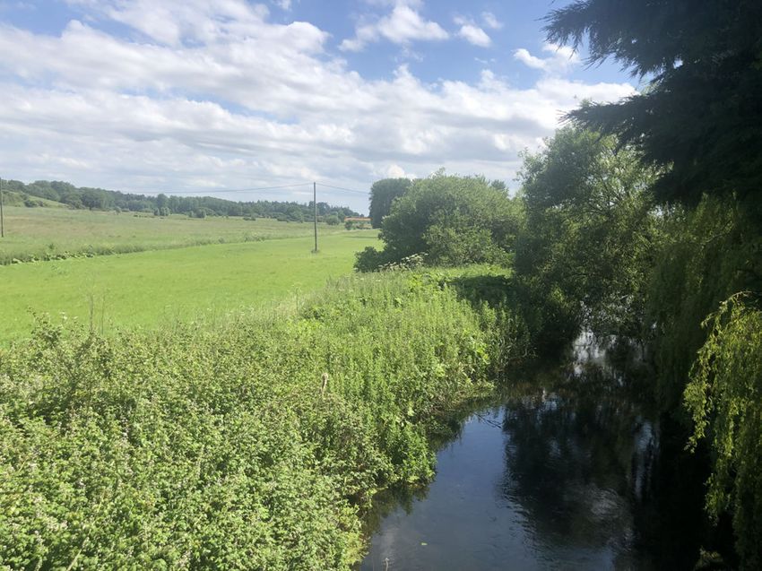
Picture 5 Wensum River Valley - Looking South From the
RNA Area are important green corridors Bridge (July 2019)
which extend the influence of the river right
across the RNA. The policies are intended to support the function and connectivity of all these
corridors and to enhance them where possible.The area to which the policies relate are shown
in Annex 6 'European Sites Map' and are referred to in the policies as “the habitat areas”. The
report and the policies are intended to add local distinction to the broader NNDC environmental
policies.
4.5.3 Any development within the RNA that may have an impact on the aquatic or terrestrial ecology
of the River Wensum and its tributaries or upon any habitat covered by section 41 Natural
Environment and Rural Communities Act 2006 being a priority habitat shall be accompanied
by an ecological assessment and Habitat Regulations Assessment. Any mitigation and/or
compensation measures outlined in such assessments will be secured via planning conditions
and/or planning obligations.
12 Ryburgh Ecological Report, Robert Yaxley (Wild Frontier Ecology) August 2018Ryburgh Neighbourhood Plan (Made Version) 17
Planning Policies 4
Policy 7
Protection & Enhancement of Local Habitats (1)
Development proposals within, or which will have a likely impact on, the River Wensum (SAC
and SSSI) habitat areas identified in Annex 6 'European Sites Map' will only be supported if the
primary objective of the proposal is to conserve or enhance the habitat, or is otherwise provided
for in national policy. Any development that may have an impact on the aquatic or terrestrial
ecology of the River Wensum habitat areas must be accompanied by an ecological assessment,
and any necessary Habitats Regulations Assessment, and demonstrate how any mitigation
and/or compensation measures identified in an assessment will be achieved.
Policy 8
Protection & Enhancement of Local Habitats (2)
To be supported, development proposals outside, and that will not have an impact on, the River
Wensum (SAC and SSSI) habitat areas identified in Annex 6 'European Sites Map', and outside
the settlement boundary identified on the map in 'Annex 5 - Settlement Boundary Map', must
demonstrate how they enhance; and how they avoid, or adequately mitigate, or as a last resort
compensate for; significant harm to wildlife-rich habitats and wider ecological networks with
reference to the Ecological Report (August 2018), or more recent ecological appraisals or
evidence.
Policy 9
Ecological Network
Development proposals that would lead to the enhancement of the ecological network, including
where they would improve habitat connectivity, will be supported.18 Ryburgh Neighbourhood Plan (Made Version)
4 Planning Policies
4.6 Protection of the Historic
Environment
4.6.1 The mid Anglo-Saxon burial site discovered
beside the River Wensum in December 2016
is referred to by a number of the consultees
as an important element in the character of
the village.
4.6.2 Having regard to the remarkable
Anglo-Saxon cemetery and to the bridge over
the river used today being at the same
location as the crossing of Saxon times and
St. Andrews Church, Great Ryburgh, likely
to have late Anglo-Saxon elements, the
village is likely to have a wealth of
archaeological sites as yet undiscovered and
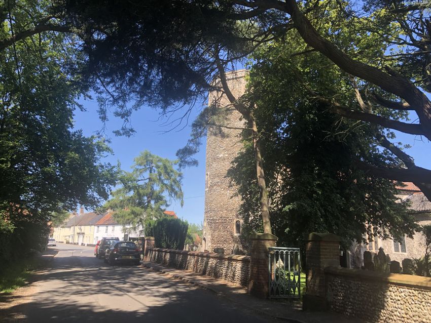
a policy in relation to those sites is desirable. Picture 6 St Andrews Church & Cottages, Station Road
(July 2019)
Policy 10
Archaeology
All development proposals must demonstrate consultation with the Norfolk Historic Environment
Record and where proposals are within 250 metres of, or otherwise have potential to affect, any
heritage asset with archaeological interest, an appropriate desk-based assessment, and where
necessary a field evaluation, must be submitted.Ryburgh Neighbourhood Plan (Made Version) 19
Neighbourhood Area Map 1
Annex 1 Neighbourhood Area Map
yburgh
1:20,000 CB
© Crown Copyright
16/05/2019
and database right
Ryburgh Neighbourhood Area 2019
North Norfolk District Council Ordnance Survey
Council Offices, Holt Road, 100018623
Cromer, Norfolk, NR27 9EN
01263 513811
www.north-norfolk.gov.uk
Annex 1 - Neighbourhood Area Map20 Ryburgh Neighbourhood Plan (Made Version)
1 Neighbourhood Area MapRyburgh Neighbourhood Plan (Made Version) 21
Consultation Process 2
Annex 2 Consultation Process
The Consultation Process
The process of developing a Neighbourhood Development Plan was initiated by and has been under
the control of the Ryburgh Parish Council since its decision to proceed with an NDP on 13th December
2016. The work of the preparation of the Plan was delegated to a working group and the minutes of
the working group’s meetings have been published at www.ryburghpc.info.
Invitations were issued to locally significant businesses/organisations/farms to appoint a representative
to take part in the working group. These included Crisp Maltings, Sennowe Estate, All Saints Primary
School, Pensthorpe, Mill Lane Nursing Home. Persons willing to carry out the work were welcomed
and invitations to join the working group or take part were issued at the public meetings to all present.
Notices of the filing of the application to North Norfolk District Council (NNDC) to seek to designate
the Parish as a Neighbourhood Area were posted on the village notice boards on 1st March 2017
and advertised in the press by NNDC between 27th February and 27th March 2017.
A first public meeting, to be held at the village hall, was notified to the community by delivery to every
house in the Neighbourhood Area of an invitation to attend, and by the posting of notices on the
village notice boards and by asking village groups to e-mail their members advising of the public
meeting. It was held on 12th July 2017 and some 90 persons attended.
At the public meeting an explanation of the process and scope of an NDP was provided by Andrew
Purdy as the chairman of the working group. Relevant elements - environment /existing businesses
in the village/infrastructure and housing were addressed by other members of the working group and
planning consultant Mark Thompson gave a short address upon what the process would entail.
Emphasis was placed upon the Plan being the construct of the consensus of the villagers wishes
and not the proposals of the working group. The meeting was opened to questions. A clip board was
passed around upon which attendees were asked to put their name, address and if available their
e-mail address. Attendees were handed a leaflet upon leaving upon which details of their contribution
towards the plan could be submitted. It was stressed and appeared to be well understood that
attendees should submit their ideas and aspirations for the future of the village over the next 20 years
as soon as they have been able to give due consideration. It was made clear submissions would be
treated as confidential and that support was available for anyone wishing to discuss any aspect.
On the 16th July, at the village dog show, held on the village field and open to all, a booth with banner
reading Ryburgh Neighbourhood Development Plan was manned and was visited by some 20 persons
who discussed aspects of the NDP.
Contributions were received by delivery to the village shop where a box was maintained in to which
they could be posted. 44 submissions were received. The register of persons attending the public
meeting was consulted to establish who may have attended and not made a submission and those
persons contacted by members of the working group, to obtain their contribution.
An analysis of all submissions, to establish the subjects of greatest concern, was produced on 7th
October 2017. Major stakeholders in the village from whom contributions had not been received were
written to on 27th October 2017. An invitation to a second public meeting to be held at the village hall
on 22nd November 2017 was the subject of a 'flyer' delivered to every house in the Neighbourhood
Area.
At the public meeting Andrew Purdy opened by explaining the process to date and inviting attendees
to view the list of submissions received to date displayed (without details of the submitter) and invited
further submissions. He explained the difference between issues that might be dealt with by planning22 Ryburgh Neighbourhood Plan (Made Version)
2 Consultation Process
policies and “aspirations” that could not. Mike Rundle took the meeting through the main themes
arising from the submissions to date and suggested examples of policies that might be possible.
Andrew dealt with progressing the aspirations. The meeting was opened to questions. Some 35
persons signed the attendance pad of the meeting. No new submissions were subsequently received.
Having established the themes of concern to the community the working group has sought and
obtained expert reports on Landscape, Ecology and Housing, each of which are annexes to this NDP.
In the case of Housing, in November 2018 Mr Michael Rayner produced a questionnaire to assist in
discovering the community’s preference for future housing. The questionnaire was delivered to every
household, accompanied by a short note advising of progress with the NDP and of the emerging
policies.There were 32 responses to the Housing questionnaire and an analysis of these was produced
for the working group by Andrew Purdy on 11th December 2018 .Ryburgh Neighbourhood Plan (Made Version) 23
Memorandum of Aspirations 3
Annex 3 Memorandum of Aspirations
Memorandum of Aspirations - for action by Ryburgh Parish Council
In October 2017 the Working Group acting on behalf of the Parish Council in the preparation of the
Neighbourhood Development Plan (“NDP”) asked the community for submissions upon the initiatives
that they would like to see within the village during the course of the next 20 years. Some of these
initiatives are capable of being dealt with by planning policies in the NDP but many are not and are
the subject of this memorandum as an aide memoir to the Parish Council that they are items requiring
attention:
Traffic Safety
This was the most frequently mentioned of all issues affecting the village. Whilst the NDP is to contain
a policy to the effect that future development generating additional HGV traffic will not be permitted,
much remains to be done to improve the traffic safety in the village having regard to the existing
traffic. The issue of traffic is the concern of the Highways Authority at Norfolk County Council and a
sub-committee of the Working Group has met with a representative of the Authority together with the
County Councillor representing the Melton Constable Division (8th August 2018), of which the
Neighbourhood Area forms a part, to discuss possible measures. The discussion is ongoing and in
the hands of Parish Councillor Neil Dandy assisted by Gill Waldron.
Footpaths/Cycle ways and access to the Countryside
53% of all consultees raised concern about these Issues including the dangers of walking from the
village to the Norwich/Fakenham bus stop (especially in the dark) and the need for a pathway alongside
the road away from the speeding traffic on a narrow carriageway. Opening a footpath across the
fields from Little Ryburgh to Great Ryburgh was a popular submission as was the creation of a
footpath/cycleway via Highfield Lane to Fakenham, to provide a route to school without the use of
the main roads. A walk alongside the river and additional access to the Countryside for dog walking
and recreation were popular suggestions. A circular walk around the Fuel Allotment was put forward
in several submissions. All these suggestions require an approach to the relevant land owner to
discuss what may be possible and the putting into effect of what maybe agreed.
Community Centre
29.26% of submissions to the Working Group raised the desirability of better community facilities.
Many favoured the building of a new Community Centre or the renovation of the existing pavilion on
the village field.
Support of the village shop, pub, butcher and the Little Chippy
29.26% of submissions to the Working Group expressed support for and the importance of these
facilities to the village. There was recognition of the many other small businesses in the village and
of a need to encourage these. The creation of a business forum was mentioned.
A better bus service was sought by 21.95% of submissions to the Working Group.
The opening/need for a school in the village in the event of extensive new development was
mentioned by 9.75% of submissions to the Working Group.
New tennis Courts, bowling green, sports facilities would be appreciated by 7.31% of consultees.
A doctors surgery in the village was a suggestion made by 7.31% of consultees.24 Ryburgh Neighbourhood Plan (Made Version)
3 Memorandum of Aspirations
Better broadband and mobile telephone reception was a suggestion also made by 7.31% of
consultees.
A dog walking area similar to the enclosed woodland facility at North Elmham was requested by
4.87% of consultees.
Mention was also made by one consultee only, in each case, of the importance of allotments, of
keeping the village litter and weed free, of developing a village programme for the sorting and better
disposal of refuse, of developing a social liaison plan with neighbouring villages and for using the
Church as a heritage centre.Ryburgh Neighbourhood Plan (Made Version) 25
Land Safeguarded for Public Access Map 4
Annex 4 Land Safeguarded for Public Access Map
NOT TO SCALE CB
Land Safeguarded for Public Access
13/08/2020
within Ryburgh Neighbourhood Area
© Crown Copyright
Land Safeguarded for Public Access
and database right
Crisp Maltings Industrial Area Ryburgh Neighbourhood Area 2020
Ordnance Survey
100018623
North Norfolk District Council
Council Offices, Holt Road, Cromer, Norfolk, NR27 9EN
01263 513811 | www.north-norfolk.gov.uk
Annex 4 - Land Safeguarded for Public Access26 Ryburgh Neighbourhood Plan (Made Version)
4 Land Safeguarded for Public Access MapRyburgh Neighbourhood Plan (Made Version) 27
Settlement Boundary Map 5
Annex 5 Settlement Boundary Map
1:10,000 CB
Settlement Boundary
03/12/2019
within Ryburgh Neighbourhood Area
© Crown Copyright
Settlement Boundary and database right
2019
Ordnance Survey
100018623
North Norfolk District Council
Council Offices, Holt Road, Cromer, Norfolk, NR27 9EN
01263 513811 | www.north-norfolk.gov.uk
Annex 5 - Settlement Boundary Map28 Ryburgh Neighbourhood Plan (Made Version)
5 Settlement Boundary MapRyburgh Neighbourhood Plan (Made Version) 29
European Sites Map 6
Annex 6 European Sites Map
NOT TO SCALE CB
European Sites
in relation to Ryburgh Neighbourhood Area 23/01/2020
Ryburgh Neighbourhood Area © Crown Copyright
and database right
River Wensum Special Area of Conservation (SAC) 2020
& River Wensum Site of Special Scientific Interest (SSSI) Ordnance Survey
100018623
North Norfolk District Council
Council Offices, Holt Road, Cromer, Norfolk, NR27 9EN
01263 513811 | www.north-norfolk.gov.uk
Annex 6 - European Sites30 Ryburgh Neighbourhood Plan (Made Version)
6 European Sites MapYou can also read