DUCK ISLAND NEIGHBORHOOD PLAN - DRAFT: December 2013
←
→
Page content transcription
If your browser does not render page correctly, please read the page content below
DUCK ISLAND
NEIGHBORHOOD PLAN
      DRAFT: December 2013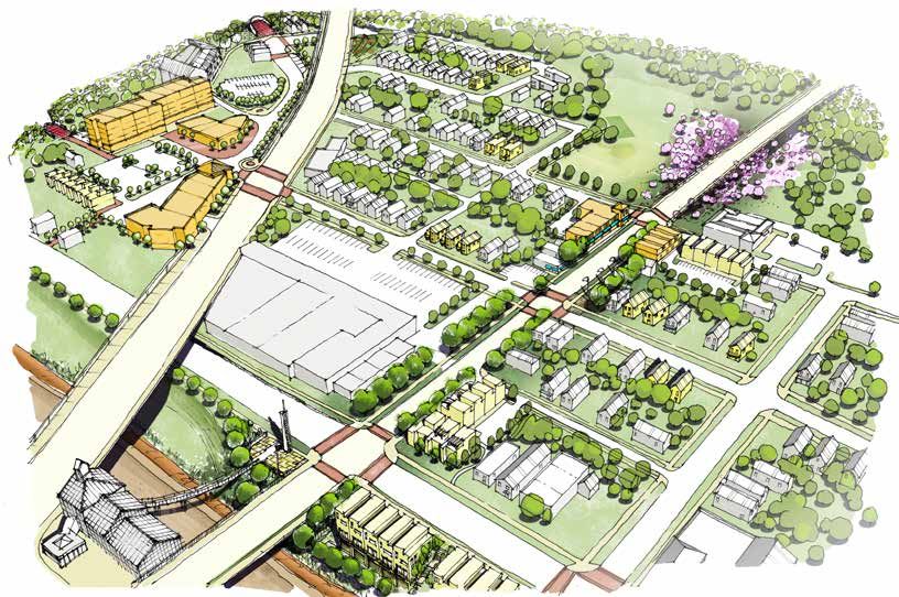
DUCK ISLAND NEIGHBORHOOD PLAN
Community Planning Charrette
December 5-7 2013

Conducted by
The Kent State University Cleveland Urban Design Collaborative
1309 Euclid Avenue, Suite 200
Cleveland, Ohio 44115
216.357.3434
www.cudc.kent.edu

for
Tremont West Development Corporation
2406 Professor Avenue, Cleveland, OH 44113
(216) 575-0920
www.tremontwest.org

with support from
Cleveland Neighborhood Progress
CONTENTS
1.0   INTRODUCTION								01

2.0   EXISTING CONDITIONS							02
      Connectivity 								      03
      Developer Interest 							 04
      Zoning and Land Use							 05

3.0   CHARRETTE PROCESS							07

4.0   DRAFT PLAN								09
      Identity									           10
      Open Space								          11
      Abbey Avenue 								       16
      Neighborhood Density							 17
      Housing Typologies  						  18
      Security & Safety								19
      Maintenance								         19

5.0   IMPLEMENTATION & NEXT STEPS					22
      Phasing Strategies							22
      Implementation Priorities						22
      Funding Sources								23
      Implementation Matrix & Timeline					23

      ACKNOWLEDGMENTS							24

      FEEDBACK									25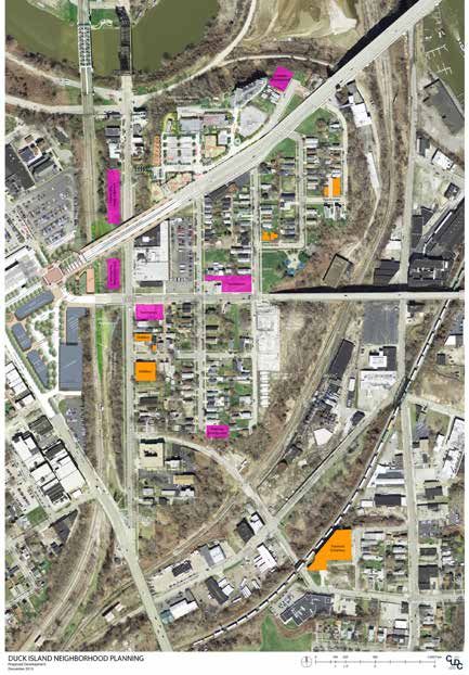
1.0 | INTRODUCTION
     In September of 2013 the Tremont West Development Corporation, with support from
     Cleveland Neighborhood Progress, engaged Kent State University’s Cleveland Urban Design
     Collaborative (CUDC) to facilitate a community planning process for Duck Island.
     This draft report is a compilation of the design and planning ideas that emerged over a
     three-day community workshop (or “charrette”) that was held at St. Wendelin’s Parish in
     early December 2013. The planning process revealed a small and insular neighborhood
     proud of its independence, but dealing with a range of issues including aging housing
     stock, concerns about crime, and areas of deferred yard and house maintenance. However,
     the neighborhood’s location and strong transit, pedestrian, and bicycle connections have
     resulted in much recent development speculation.
     This plan is an effort to mediate new development opportunities with the needs of the
     existing Duck Island residents. This report makes recommendations about neighborhood
     identity; open space, including landscape strategies and recreational connections; higher-
     density corridors like Abbey Avenue and Columbus Road; and neighborhood infill and
     housing typologies. This document is a visioning road map intended to balance high-quality
     new development with existing neighborhood character.
     All ideas and recommendations in this report are still in draft form and are open to further
     discussion. Please see the final page for contact information to leave feedback.

                                                                                                    1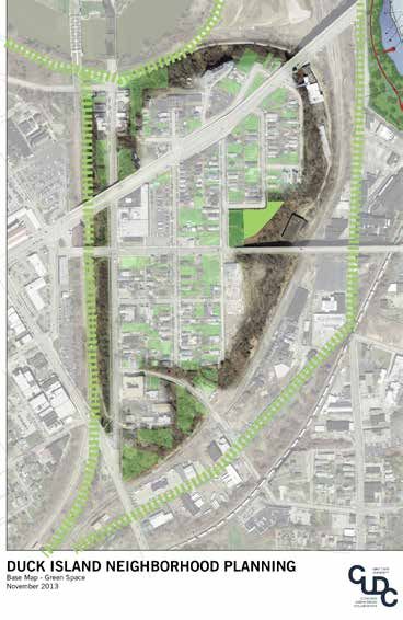
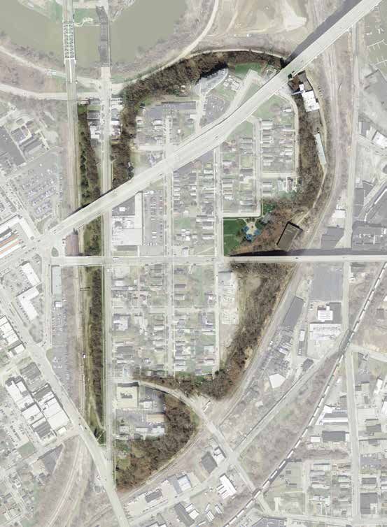
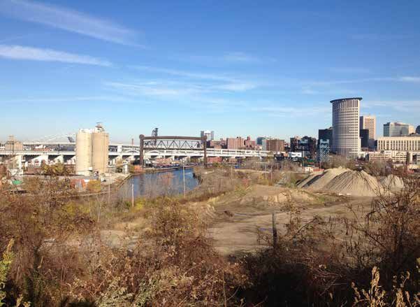
2.0 | EXISTING CONDITIONS
    Duck Island is at the western end of the Lorain-Carnegie Bridge and therefore receives much
    through-traffic on Lorain Avenue from cars heading in and out of Downtown Cleveland.
    However, the neighborhood is relatively disconnected from both Ohio City and Tremont, its
    two larger neighbors. This disconnection is largely a result of topography: the neighborhood
    surrounded on the north, east, and south by a sharply sloping drop-off into the industrial
    Flats, and on the west by the trench for the RTA Red Line train. Duck Island is essentially a
    small plateau surrounded by a green “moat” of underbrush and forestation.

    This topographical distinction also creates many dead-end or single-block streets, creating a
    sense of separateness, isolation or oasis. The sharp topography and the near-west location
    lends itself to incredibly striking views of Cleveland’s downtown and its industrial Flats all
    along the north and east sides of the neighborhood. Building stock is largely comprised of
    scattered single-family houses, many nondescript and aging.

2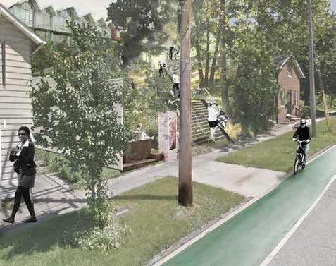
Connectivity
Though the Duck Island neighborhood has
a relatively low-profile as compared to other
Cleveland neighborhoods, it is well positioned
to become one of the city’s most a walkable,
transit-oriented neighborhoods.
ROADS: Duck Island’s major streets include
Lorain Avenue, leading to Downtown; Abbey
Avenue and, to a lesser extent, Willey Avenue,
connecting to Tremont; and Columbus Road,
connecting to W. 25th Street and, when the lift
bridge over the Cuyahoga is repaired, to the
industrial Flats.
GATEWAYS: Three major gateway points into
Duck Island: (1) the connection along Abbey
Avenue to Gehring/Lorain, with access to the
West Side Market; (2) the connection across
the Abbey Avenue Bridge into Tremont; and
(3) the intersection at the south of end of
Columbus Road joining W. 25th Street. All
three intersections are currently underutilized
as neighborhood gateways.
BIKE & TRANSIT: Existing & proposed bike
routes and greenways, such as the bike path
along Abbey Avenue, the multi-use path along
the Lorain-Carnegie Bridge to Downtown, and
the proposed Towpath Extension, Red Line
Greenway, and Lake Link Trails all pass by or
through Duck Island. In addition, the RTA Red
Line station at Gehring and Lorain Avenue is a
strong anchor point to the neighborhood and
a quick connection to Downtown.

                                                  3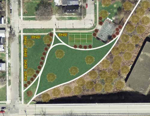
Development Interest
    Because of its close proximity to Downtown, Ohio City, and
    Tremont, and its connections to transit and bicycle infrastructure,
    Duck Island has recently become the target of much developer
    speculation. The scale of proposed development ranges from
    single-family infill housing, to multi-lot townhouses, to large-
    scale mixed-use development. The map below indicates
    planned development, either plan from developers’ architectural
    drawings, or more generally in orange for planned development
    and pink for speculative development.
                                                                               A few of the proposed developments for Duck Island.
    Duck Island residents recognize that their neighborhood is likely          TOP: Proposed townhome development along West
    to become more dense and more prominent than its current                   19th Street south of the Abbey Animal Clinic.
    state. This planning process is intended to find ways to shape this        MIDDLE: A mixed-use development located north of
    new development in ways that maintain the aspects of the neigh-            Lorain, including housing and ground-floor commercial.
    borhood most valued by existing residents’.                                BOTTOM: A 4-unit townhome development proposed
                                                                               for West 18th St.

                                                               E
                                                            AV
                                                        N
                                                  R  AI
                                                LO

                                    ABBEY AVE
                      COLUMBUS RD

                                                                           E
                                                                        AV
                                                                      Y
                                                                   LE
                                                                   IL
                                                              W

4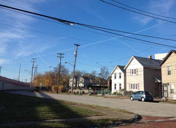
Zoning and Land Use

ZONING                                                   VACANCY - OWNERSHIP
Existing zoning in Duck Island is comprised of           A preliminary map of vacancy in the neighborhood.
four major categories: 1) General Industry, in gray,     This map breaks down the vacancy by ownership:
surrounding the neighborhood on the north and west;      1) lots owned by the City of Cleveland; 2) lots
2) Semi-Industry, in purple, along Columbus Road         owned by the Cuyahoga County land bank; 3) lots
and the majority of Lorain Avenue; 3) Multi-Family, in   owned by developers who may or may not already
brown, the southern half of the neighborhood fabric;     have specific plans for the parcels; and 4) other
and 4) Two-Family, in yellow, in some of the northern    privately-owned lots used as side yards for adjacent
neighborhood fabric. A fifth category in pink, Local     homeowners.
Retail Business, is mainly along Abbey Avenue
between W. 20th and W. 19th Avenues.

                                                                                                                5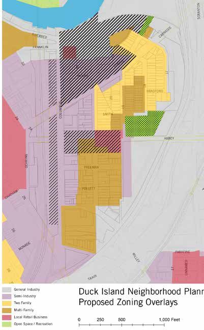
E
                                                                                                                             AV
                                                                                                                        IN
                                                                                                                     RA
                                                                                                                   LO

                                                                                           ABBEY AVE

                                                                             COLUMBUS RD

                                                                                                               E
                                                                                                            AV
                                                                                                           Y
                                                                                                       LE
                                                                                                       IL
                                                                                                       W

    NON-RESIDENTIAL ASSETS                                     EXISTING & PLANNED OPEN SPACE
    When institutional, industrial, and commercial uses        Duck Island has only one formal park, Abbey Park,
    are overlaid on the neighborhood, it is clear that while   but it has a large amount of planned and potential
    Duck Island is primarily a residential neighborhood,       open space. The Red Line Greenway, a three-mile
    there are some major non-residential uses. Morgan          bike and pedestrian path being developed by the
    Services, on the northeast corner of Columbus and          Rotary Club, will pass just to the west of Duck Island
    Abbey Avenues, is the largest commercial business,         and link to downtown Cleveland at the Carl B.
    but other commercial uses include Abbey Market             Stokes U.S. Courthouse, the Red Line Rapid station
    and two bars, Duck Island Club and the Velvet Tango        at West 25th Street, and the Zone Recreation Center
    Room. St. Wendelin’s Parish, at the south end of           at West 65th Street. The Towpath and Lake Link
    Columbus, is the only church in the neighborhood,          Trails will align with the eastern and northern edges
    and it shares a campus with the Head Start School at       of the neighborhood. Also, the slopes that surround
    Columbus and Willey Avenues.                               the neighborhood should be recognized as a
                                                               potential open space network. Aggregated together,
                                                               this map illustrates the neighborhood’s potential
                                                               open space network, if existing areas and projects
                                                               are connected thoughtfully.

6
3.0 | CHARRETTE PROCESS
A charrette (or workshop) is a brief but intense design exercise that produces a wide range of
ideas that are developed and discussed in a public format.
The Duck Island charrette began with a series of focus group meetings which brought
together local developers, public officials, and major property owners. This was followed by
a community meeting at which the project team presented existing conditions and gathered
input from neighborhood residents and stakeholders. The project team asked a series of
questions about the neighborhood and subsequently facilitated group breakout sessions.
First, residents were asked to quickly identify what they like best about the neighborhood,
where they like to go, and problems they would like to see fixed (see opposite page for
responses). Then groups met around maps and discussed four main themes: open space
and connections; neighborhood infill and density; corridor development; and neighborhood
identity.
The following day, the project team synthesized the input from the community and
developed initial design concepts. An informal input session was held at St. Wendelin’s
where community members could stop by and offer further input. A second public meeting
was held the following day to present initial design concepts and open a dialogue for a
shared vision of the neighborhood. Feedback from this session was gathered in this report
with a third community meeting scheduled to take place in January, 2014.
7RESPONSES, BRAINSTORMING EXERCISE:
Q: What do you like to do in the neighborhood in your
Q: What are three problems in the neighborhood that
free time?
you would like to see fixed?
A: Run | Jog | Bike | Take RTA | Walk to the
A: Industrial eyesores | Non-maintained houses |
West Side Market | See the views | Visit relatives,
Trash in vacant lots | Vacant houses | Vacant lots
neighbors, friends | Enjoy walks in the park | Walk
| Neglected landscapes | Substandard housing |
my dog | Walk downtown | Work on yard and garden
Graffiti | No food options | Parking issues | Park &
| Sitting on my porch swing | Listen to Indians games
playground feels unsafe | Junkyards | Lack of density
on the porch | Go to St. Wendelin’s for functions |
around Abbey Avenue | Perceived crime | Lack of
Hike the hills | Walk to W 25th and Tremont
investment | Unsafe feeling for diverse background
Q: Where are the best places to go in the (racism) | Too many electrical lines | Drug activity
neighborhood? Why?
Q: If you could have any neighborhood amenity, what
A: View of the City at the end of Lorain | Grove are some things you would want?
Court | Down Columbus Road Bridge to view A: Tie into Towpath extension, Lake Link, and Rotary
Downtown | Hillside | Watch big boats on river | trails | Community garden | Maintain architecture
Abbey Bridge - convenient & well-lit | Bridge into | Walking trail | Park that feels safe | Picnic
Tremont - good views | Abbey Park | Playground pavilion | Dog area in park | Tennis courts |
St. Wendelin’s - welcomes all | Velvet Tango Commercial/restaurant area | More stores, shops,
Room during Happy Hour | Duck Island Club art studio | Diner | Grocery store | Easier access
neighborhood is eclectic | Lorain Bridge to RTA, instead of walking around | Streetcar to
Tremont | Walkability on Abbey
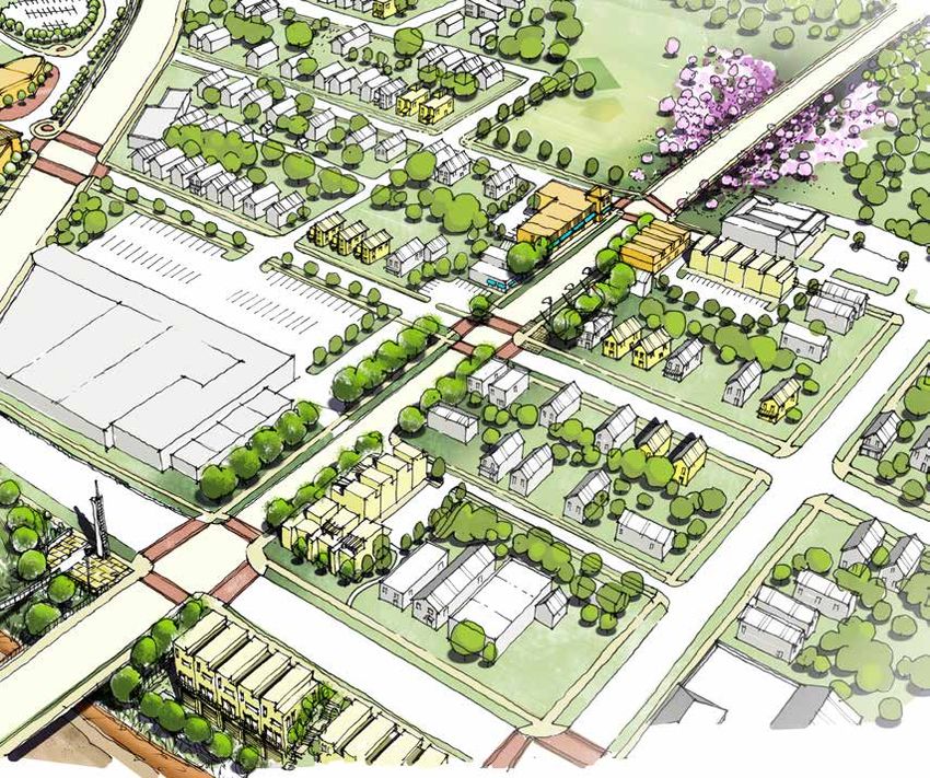
84.0 | DRAFT PLAN
The Duck Island Neighborhood Planning process has produced general recommendations
for organizing future development, as well as detailed recommendations regarding
neighborhood identity, open space, residential density, infill strategies, housing typologies,
safety, and maintenance. A preliminary implementation is being developed, to be completed
with the input of the community at a final meeting in January of 2014.
The plan’s two organizing ideas are to:
• Apply various landscape strategies to the sloping topography that surrounds the
neighborhood to create a varied,but linked, network of open space.
• Develop Abbey Avenue as a small-scale mixed-use corridor with a cohesive streetscape
design, anchored by intersections acting as gateways into the neighborhood.
Residential densities can vary within the neighborhood, in order to retain the small-scale
character of the interior streets. The primary corridors, Abbey Avenue, Lorain Avenue, and
Columbus Road allow for higher densities. The area north of Lorain Avenue is best suited
for higher density, mixed use development, provided that public access is still provided for
connectivity, green space access, and views of downtown and the river.
E
AV
Y
BE
AB
E
AV
IN
RA
LO
CO
LU
MB
US
RD
9Neighborhood Identity
Duck Island is a small neighborhood, tucked between Ohio City and Tremont, but it has a
distinct character in terms of architecture and unique neighborhood destinations. During the
charrette, residents expressed pride in their location, their views, and the neighborhood’s
under-the-radar status. It is very important to Duck Island residents that the neighborhood be
viewed as separate and distinct from its two neighboring communities. For example, Abbey
Avenue should not attempt to replicate either W. 25th Street in Ohio City or Professor Avenue
in Tremont. New development in Duck Island should to retain a small-scale character that is
distinct from the city at large. Signage, streetscape elements, and scale of new development
should take these distinctions into account.
Also, the slopes which surround Duck Island, seen on the following page, are a physical
feature that sets the neighborhood apart, physically and symbolically, from the rest of the
city. With an integrated landscaping and maintenance strategy, the slopes could unite the
neighborhood and act as an identifying feature.
TOP LEFT: The Velvet Tango Room exemplifies the
neighborhood’s low-key appeal as a hidden treasure for
those in-the-know.
BOTTOM LEFT: The Duck Island Club, another
distinctive neighborhood spot.
RIGHT: Neither Tremont nor Ohio City, Duck Island is
special in its own right.
10Open Space
Duck Island’s defining topography clearly delineates the boundaries of the
neighborhood. However, at present the sloping hillside is underutilized and lacks
a cohesive presence in the neighborhood. Given the strong feedback in favor of
walking, views, and other recreational opportunities, this slope, when linked when
defined by a series of landscape strategies, could become a network of productive
green space that provides ecological and social benefits to Duck Island while defining
its identity. It should be noted that in no case should all plantings be removed, as the
soil is subject to erosion and landslides. But removing some of the overgrowth would
give the slopes a well-tended appearance and reduce concerns about crime.
SLOPE STRATEGIES
create public overlook at end
OVERLOOK of lorain Avenue to downtown
explore stormwater capture on
STORMWATER CAPTURE slope heading towards river
create hillside link down to
columbus road & lake link trail
HILLSIDE LINKAGE
clear undergrowth on
CLEAR UNDERGROWTH east-facing slope for viewshed
frame abbey avenue bridge with
SEASONAL PLANTINGS successive seasonal plantings
intersperse seasonal plantings
with flowering trees for height
FLOWERING TREES
make connections from
REDLINE GREENWAY columbus road to planned
redline greenway
treat toxic industrial sites with
phytoremediation plantings
REMEDIATION LANDSCAPE
consider future pedestrian/bike
HILLSIDE LINKAGE connections from e. 20th st
down to willey avenue
formalize park space at south
end of columbus road, connect
to greenway
COLUMBUS POINT
MICRO WETLAND retain and encourage wetland
plantings at base of hill at
willey avenue
11Stormwater Capture
FAR LEFT: The northern slope of Duck
Island, close to the Cuyahoga River,
could be used for terraced or switchback
stormwater capture in order to slow or
halt stormwater before it flows into the
river, reducing the overall load on the
watershed. (Schematic Drawing for the
Cistern Steps on Vine Street in Seattle,
WA. Source: Growing Vine Street)
TOP AND BOTTOM RIGHT: The
stormwater system could be attractively
planted and designed in such a way to
allow public access and use.
Hillside Linkage
FAR LEFT: The southern end of W. 20th
Street once had a pedestrian link to
Willey Avenue. Though residents raised
safety concerns about reconstructing
this feature, in the future when the
Fairmount Creamery project and other
development bring more activity to Willey
Avenue, the idea could be revisited.
(Source: The Cleveland Memory Project)
TOP RIGHT: The staircase could be
wooden, or it could be a switchback
ramp for greater accessibility.
BOTTOM RIGHT: As bicycle paths will
pass along Duck Island, the hillside link
should be designed in such a way to
provide ease of bicycle transport up and
down the hill.
Clear Undergrowth
FAR LEFT: The west-facing slope of
Duck Island north of Abbey Avenue
has potentially good views of Down-
town and the Flats, but is hampered by
underbrush. Though the hillside cannot
be completely cleared due to erosion
concerns, overgrowth could be removed
around existing trees.
TOP AND BOTTOM RIGHT: Some
alternative ideas for landscaped slopes.
Residents expressed concern about
creating formal pathways or recreational
space along this slope, as they have
security concerns about the industries
in the Flats below.
12Seasonal Plantings & Flowering Trees
Though the slopes on either side of the
Abbey Avenue Bridge (heading east to
Tremont) could be planted as gateway
into the neighborhood and as an iden-
tifying feature for Abbey Park. Using
successive seasonal plantings, the slope
can be layered with plants that will bloom
throughout the spring and summer,
calling attention to the neighborhood entry
point through color and texture. Similarly,
flowering trees can be interspersed where
height is preferred.
Remediation Landscape
The area at the base of Willey Avenue,
particularly along the slope to the north,
is reportedly contaminated with industrial
remnants, complicating any potential
development. However, by using a series
of phytoremediation plantings, which draw
industrial toxins out of the soil in a slow
but controlled process, it may be possible
to clean the site up without embarking on
an intensive and disruptive excavation.
The plantings would visually tie into the
larger landscape system, while providing
ecological benefit.
Wetland Plantings
On the south side of Willey Avenue at the
base of the Duck Island slope is a patch of
fragmites, tall grasses that predominantly
grow in wet soils. Though more extensive
study is required, this is a potential
indicator of former or neglected wetlands.
Part of the Duck Island slope strategy
should be to intentionally support and
bolster these wetland sites with additional
plantings and wetland management.
13West 17th Street Overlook
LEFT: The end of W. 17th Street (where it
intersects with Moore Court) attracts frequent
informal public visits for views of Downtown.
Public access to the “million dollar view” of
Downtown and the Flats should be retained,
even as new development occurs north of Lorain
Avenue.
RIGHT: The overlook could include a structure
such as this, to enhance the view.
Bridge Berm Garden
TOP LEFT: The existing berm alongside the
Lorain-Carnegie Bridge is not well-maintained;
residents have noted the area looks disorderly
and harbors trash and other unsavory uses.
BOTTOM LEFT: Instead of standard grasses,
the berms could be planted with “low-mow”
grass that looks like a lawn but requires less
maintenance. This could also allow for sledding
in the winter, something residents noted is
difficult with higher grasses.
BOTTOM RIGHT: Alternatively, the south-facing
slope could serve as a location for terraced
community gardens.
14Abbey Park
Residents noted that Abbey Park, though
difficult to see from Abbey Avenue, is very
heavily used, primarily for its basketball
court. However, problems with the park
include loitering, drugs, and public urination.
Approximately $400,000 has been set aside
for a splash park in Abbey Park in the City
of Cleveland’s capital plan. Many residents
expressed an interest in other park features
and investments, instead of a splash park.
The lots along the western edge of Abbey
Park (adjacent to W. 19th Street) are actually
not part of the park. Several are privately
owned by an industrial landowner (nearest
the intersection of W. 19th Street and
Abbey Avenue). However, the parcels at
the southeast corner of W. 19th Street and
Smith Court are in the city’s land bank, and
would be relatively easy to include in a park
redevelopment. In any case, all of the parcels
along the western edge of Abbey Park should
be re-zoned as green space to protect the
park from development incursions.
Duck Island residents appear divided about
whether the basketball court should remain.
Many noted that, because it is one of the few
full courts on the west side, it is often used by
people who drive into the neighborhood and
park on side streets, often leaving trash and
disrupting neighbors. However, these problems
may be solved with some basic investments
including a public bathroom and security
cameras, in order to cut down on the nuisance
issues, while retaining the neighborhood
advantage of a basketball court.
Columbus Point & Greenway Connections
RIGHT: A rendering of the Rotary Club’s
planned Redline Greenway, which will
run directly west of Duck Island. (Source:
Vocon). The Greenway will be an asset to
Duck Island; however, particular care should
be given to connections at Columbus Road
& W 25th Street, and Columbus & Abbey
Avenue.
LEFT: The intersection of Columbus & W.
25th Street is wide, confusing, and unfriendly
to pedestrians. When the Redline Greenway
is implemented, this corner could become
of even greater importance in anchoring the
green space network of Duck Island.
15Abbey Avenue
Abbey Avenue serves as the primary connection between Ohio City and Tremont. It is
also Duck Island’s “Main Street” although it does not register as a primary corridor for the
neighborhood. This is because very few buildings actually front onto Abbey Avenue; instead
the street is lined with the sides of houses and other buildings. Even Abbey Market, an
anchor use on Abbey Avenue that has both fans and detractors, has its main entrance off a
side parking lot, rather than facing Abbey.
Residents said that, while Abbey Avenue would be a center of commercial activity, it should
still retain a small-scale, neighborhood feel. Any retail or mixed-use development should
primarily serve residents from the immediate surrounding area. Particular attention should
be paid to the intersections at Abbey Avenue and Columbus Road, and Abbey & W. 19th
Street, as the primary “gateway” intersections into Duck Island. These corners should be
anchored by well-designed, mixed use development projects.
Particular consideration should be given to the possibility of the RTA Redline Greenway
project moving forward. This would conceivably stimulate development demand in the
area for housing. Developer schematics have shown that building into the hillside, on land
currently owned by the RTA, is possible. Pedestrian links down to the trail from Columbus
Road would provide connectivity to the RTA station at W. 25th and the new trail. At the
eastern end of Abbey Avenue, infill development and an enhanced neighborhood park could
further reinforce a sense of neighborhood identity.
TOP: Schematic concept for housing
development along Columbus Road and the
Redline Greenway.
BOTTOM: Abbey Market has drawn criticism from
residents for its appearance and the noisy patrons
it sometimes attracts, particularly after dark.
However, residents appreciate the convenience
of having a small commercial service directly in
their neighborhood. Facade improvements could
reorient the entrance toward Abbey Avenue and
clean up the appearance of the building.
16Neighborhood Density
Residents of Duck
Island discussed the
kinds of development
that should be allowed
in the neighborhood.
Preliminary consensus
began to emerge with
regard to following density
diagrams:
TOP: On interior streets,
small-scale infill housing,
whether one structure per
parcel or, less popularly,
townhomes, is preferred.
Heights should be
capped at 35 feet.
MIDDLE: The two main
corridors in Duck Island,
Columbus Road and
Abbey Avenue, can
support higher densities.
Abbey Avenue should
be developed as a
small-scale mixed-use
street with commercial,
retail, or food service
businesses on the
ground floor and housing
above, interspersed with
townhomes and other
housing types. The
slope on the west side of
Columbus Road can also
handle higher densities,
although any development
needs to prioritize public
access and views to the
Redline Greenway with
frequent breaks between
buildings.
BOTTOM: The area
north of Lorain Avenue
can support higher
densities than the rest
of the neighborhood.
However, just as along
Columbus Road, any
development here should
also prioritize public
access with pedestrian
and/or bike paths leading
through the area.
17Housing Typologies
Duck Island currently has an eclectic
range of smaller-scale houses and
retail businesses. A variety of housing
types could be designed to fit into
the neighborhood, provided that new
development respects the size and
massing of existing homes.
1
Duck Island is an ideal neighborhood
for people to “age in place” due to the
close-knit character of the community,
convenient access to public transit,
and strong neighborhood institutions
like St. Wendelin’s parish. There is
a large privately owned vacant site
immediately east of St. Wendelin’s
campus. This site is well-suited for 2 4
senior housing, possibly development
in partnership with the Catholic
Diocese. If this site is not available,
other options could be explored for
senior housing in the neighborhood.
Market trends reflect the fact that
today’s seniors are not interested in
what their parents had in terms of
assisted care or nursing homes. Many
seniors would prefer to remain a part
of the community, rather than be 3 5
sequestered in elderly-only facilities.
Senior apartments or senior co-
housing would provide an alternative
for older residents to be a remain
Duck Island, and for those who
might want to move here.
1: Residential units above neighborhood-
scale retail would help to establish Abbey
Avenue as Duck Island’s “Main Street.”
2: Townhouses with garages tucked below
would be an appropriate typology for new
development along Columbus Road that
fronts the Redline Greenway trail.
3: 1-½ to 2-story infill homes would fit in
7
well with existing housing on Duck Island’s
side streets. 6: Senior apartments could be tucked into the
6
4: Roof terraces would enable residents to hillside behind St. Wendelin’s Parish.
enjoy the neighborhood’s spectacular views. 7: Example of senior co-housing development
5: A mixture of traditional and contemporary where residents live independently but share
architectural styles could expand the market common areas and meals.
appeal of the neighborhood.
18Zoning
This zoning overlap map reflects the
discussions that occurred during the
charrette. The part of the neighborhood
north of Lorain is already slated for a
zoning change, as seen in the plan below.
Additional changes in the neighborhood
could be made along Abbey Avenue and
Columbus Road to encourage mixed-use
and multi-family housing, respectively.
Additionally, the whole of Abbey Park and
its adjacent parcels to the west should be
rezoned as Open Space, as should the land
at the end of Lorain Avenue, which would
enable the public to retain access to views
from the neighborhood of Downtown, the
Cuyahoga River, and the Flats.
Duck Island Proposed
Zoning Overlay
19Additional Recommendations
Green Alley
BELOW: Alleys in Duck Island are an under-utilized
resource. One block in particular–between W 19th Street
and W 19th Street, north of Smith Court–could serve as
a prototype for a new approach to Cleveland’s.
TOP LEFT: The current alley is overgrown,
unmaintained, and lacks an outlet at the north end.
BOTTOM LEFT: A rendering from Los Angeles’ proposal
for the Avalon Green Alley Network (Trust for Public
Land/Salt Landscape Architects) illustrates some basic
principles of a “green alley,” which manages stormwater
and allows for vehicular access to the rear of the block’s
lots in order to minimize on-street garages and curb
cuts. Further study is needed to determine the best out-
let for the alley, but preliminary survey indicates W. 18th
Street may be the better option.
W 19th St
Ca
rn
eg
W 19th Place
ie
Smith Ct
Av
e-
W 18th St
Public Access at Moore Court
As large-scale development occurs north of
Lorain Avenue, and larger trail networks like the
Lake Link Trail and the Towpath extension are
implemented in the Flats, public access must be
maintained through the northern area of Duck
Island. It may be possible to use Moore Court, a
public right-of-way, as a hillside connection from
Columbus Road.
BELOW: Columbus Road at the existing Moore
Court right-of-way.
LEFT: A potential public connection at Moore
Court
20Security & Safety
SECURITY CAMERA LIGHTING UNDER BRIDGES
FAR LEFT: Security cameras in strategic
locations, which may include Abbey Park,
may address some of the neighborhood’s
safety concerns.
NEAR LEFT: Lighting under the bridge over-
passes in the neighborhood would make the
neighborhood feel safer and more walkable,
by night and by day.
Maintenance
GRAFFITI MANAGEMENT LANDSCAPE CLEARING STRATEGY
LEFT: Graffiti needs to be addressed
promptly, or the problem is likely to spread.
Security cameras, clean-up efforts led by
Tremont West Development, and block
watch volunteers can help to keep graffiti
problems under control.
RIGHT: Organized efforts to clear weeds
and brush on the slopes surrounding
the neighborhood would improve the
appearance of this green space and open up
new opportunities for residents to use this
green space.
215.0 | PHASING &
IMPLEMENTATION
Phasing Strategies
At a final community meeting in January, 2014 residents, property owners, and other
neighborhood stakeholders will have an opportunity to identify their priorities for
implementation among the recommendations discussed in this plan. They will also be able
to suggest additional ideas and recommendations for inclusion in the plan. Recognizing all
of the recommendations cannot happen at once, the planning process needs to outline the
entire range of community priorities and rank them by short-, mid-, and long-term efforts,
and identify the most important things to do first.
Implementation Priorities
(preliminary--to be completed following the final public meeting)
Legislative Process
1. Following any revisions to the plan document, TWDC should submit the plan for
review and adoption by the Cleveland City Planning Commission.
2. If there is community consensus around the recommendations in this plan, TWDC
and the Cleveland Planning Commission staff, in partnership with the Councilman,
should initiate zoning changes consistent with the plan recommendations for devel-
opment. These changes include re-zoning the interior streets in the neighborhood
for single- and two-family residential uses; re-zoning sites along Abbey Avenue for
higher-density rowhouses and neighborhood-scaled mixed use development; re-zon-
ing sites along Columbus Road for higher-density redevelopment; and re-zoning
sites along Lorain Avenue and the area north of Lorain for higher-density mixed use
development, taking care to ensure public access to important views and amenities,
and interconnectivity of streets and sidewalks throughout the neighborhood.
3. The parcels along the western end of Abbey Park should be rezoned as green space
to ensure that they remain dedicated for park use. The publicly owned parcel at the
northern end of W. 17th Street (where it intersects with Moore Court) should also be
rezoned as green space.
Development
1. Work with developers to establish a development fund for the neighborhood. When
new development occurs within the neighborhood, the developer would pay into the
fund on a one-time, per-unit basis. TWDC would establish a committee of residents
and advisors to decide how these funds would be used for the betterment of the
neighborhood.
2. Work with the owners of Abbey Market to design, finance, and implement a range of
storefront and parking lot improvements.
3. Initiate a conversation with the Catholic Diocese regarding the possibility of senior
housing development in the neighborhood.
22Green Space and Infrastructure
1. Develop a landscape plan for the slopes that surround the neighborhood,
incorporating the range of landscaping treatments described in this plan.
2. Engage a landscape architect to work with the community to develop a detailed plan for
Abbey Park that incorporates the range of uses residents would like to see in the park. In
the short-term, talk with the City about installing portable restrooms in the park.
Safety and Maintenance
1. Convene a neighborhood task force to determine whether and where security
cameras, tied to the Cleveland Police Department, should be installed.
2. Work with the City to target inspection and enforcement efforts toward properties
in the neighborhood that are in poor repair. Increase community awareness of
assistance programs aimed at home repairs and maintenance.
3. Develop a lighting plan for the bridge underpasses; secure Community Development
Block Grant funds, a Neighborhood Connections grant, or other funding to pay
for the installation of lighting. Work with the city to determine a plan for long-term
maintenance of the lighting.
4. Develop a graffiti response team, through TWDC and neighborhood block clubs, that
can respond quickly to incidents of graffiti and other vandalism in the neighborhood.
Funding Sources
(to be completed following the final community meeting)
Implementation Matrix & Timeline
(to be created at the final community meeting)
23ACKNOWLEDGMENTS
The Duck Island Neighborhood Planning Charrette was conducted with the support
and participation of the following organizations and individuals:
TREMONT WEST DEVELOPMENT CORPORATION
Cory Riordan | executive director
Andy Thomas | neighborhood safety coordinator / community organizer
Sammy Catania | director of physical development & property management
Scott Rosenstein | community involvement manager
Michelle Davis | marketing & fund development director
KENT STATE UNIVERSITY CLEVELAND URBAN DESIGN COLLABORATIVE
Terry Schwarz | director
David Jurca | associate director
Kristen Zeiber | project manager/urban designer
Jeff Kruth | urban designer
Julie Whyte | post-graduate fellow
Beth Lamb | marketing and communications manager
Bryan Radwancky | office manager
ST WENDELIN PARISH
Father Robert Kropac | pastor
Susan XXXXX | office manager
Jim Stracensky | custodian
CLEVELAND NEIGHBORHOOD PROGRESS
Justin Fleming, Esq. | director of real estate services
Colleen Gilson | vice president of cdc services
Wayne Mortensen | director of design & development
24FEEDBACK
The Duck Island Neighborhood Plan is still in draft form, and this report has been
made available for wide distribution because we want to hear what you think of it!
Any of the suggestions and findings addressed in the previous pages are open to
discussion. We welcome all ideas and conversations.
In mid- to late-January of 2014, Tremont West will convene a final community
meeting to review this draft plan and recommendations. The Cleveland Urban Design
Collaborative will be there to facilitate discussion and collect feedback and alternative
ideas from Duck Island residents and stakeholders. We hope to see you there!
If you have feedback, thoughts, or ideas that should be addressed prior to that
meeting, please get in touch with Tremont West:
(216) 575-0920 | info@tremontwest.org
Otherwise, please be on the lookout for announcements about the meeting date
and time in the very near future. Thanks to all Duck Islanders for your feedback and
support during this planning process.
25You can also read