North York Moors Local Plan - Topic Paper A Sense of Tranquillity, A Strong Feeling of Remoteness and Dark Night Skies - North York Moors National ...
←
→
Page content transcription
If your browser does not render page correctly, please read the page content below
North York Moors Local Plan
                                          Topic Paper
  A Sense of Tranquillity, A Strong Feeling of Remoteness
                  and Dark Night Skies

This document sets out the background and evidence regarding proposed policies for conserving and enhancing
     three of the North York Moor’s National Park’s Special Qualities - Tranquillity, A Strong Feeling of
                                    Remoteness and Dark Night Skies.

                                                July 2018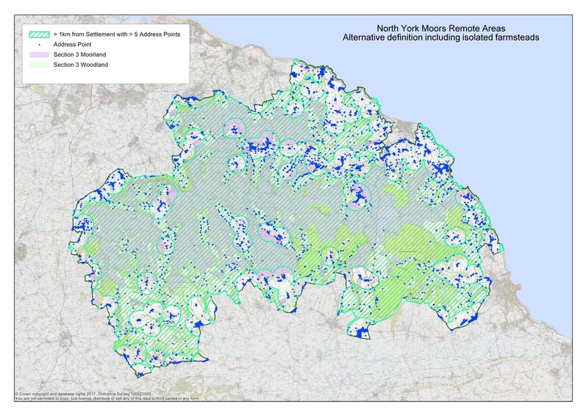
Cover Photo Credit: Steve Bell.

Topic Paper - Tranquillity, Remoteness and Dark Night Skies policies – July 2018.   2
Contents

  1.    Introduction .......................................................................................................................... 4

  2.    Policy context ....................................................................................................................... 4

  3.    Why introduce new policies? ................................................................................................ 5

  4.    Tranquillity ............................................................................................................................ 6

  5.    A strong feeling of remoteness ........................................................................................... 10

  6.    Dark night skies .................................................................................................................. 17

  7.    Next Steps.......................................................................................................................... 20

  Appendix 1: CPRE National Tranquillity Map. ............................................................................ 21

Topic Paper - Tranquillity, Remoteness and Dark Night Skies policies – July 2018.                                                             3
A Sense of Tranquillity, A Strong Feeling of Remoteness and
Dark Night Skies
“Yet it is just because this is a densely populated and highly industrial country that the need for
National Parks is so pressing. Four-fifths of the population dwell in urban areas, many of them in
the smoke-laden atmosphere and amid the ceaseless traffic and bustle of our industrial towns and
larger cities. They need the refreshment which is obtainable from the beauty and quietness of the
unspoilt country.”
The 1947 Hobhouse Report which led to the creation of National Parks in England.
1. Introduction
1.1 All national parks in England, Wales and Scotland share a statutory purpose to promote
understanding and enjoyment of the 'special qualities' of their area. For the North York
Moors, twenty eight special qualities have been identified and are set out in the National
Park Authority’s Management Plan1. Three of the most highly valued qualities are to do with
attributes that affect the way people experience the National Park:
Tranquillity
A Strong Feeling of Remoteness
Dark Skies at Night
1.2 As part of the preparation for the new Local Plan we asked people what they value about
the National Park through a public consultation in September 2016. Conserving special
qualities for future generations was one of the main themes that came out of the
consultation - protecting the beauty and tranquillity of the countryside and its dark night
skies were all mentioned as important for the new Local Plan. A further consultation on
specific policies to protect these special qualities took place in December 2017 and
responses to this consultation have also been taken into account in drawing up our
proposed approach.
1.3 This paper has been produced to support the ‘Preferred Options’ consultation on the new
Local Plan and is intended as a resource for anyone who requires more information on how
and why we have developed the proposed policies relating to tranquillity, remoteness and
dark skies at night.
1.4 Consultation on the Preferred Options document is an important stage in the preparation of
the new Local Plan and policy proposals contained in this paper may be subject to change.
No weight can therefore be applied to this document in decision making.
2. Policy context
2.1 The English National Parks Government Vision and Circular 2010 charged National Park
Authorities and their key partners with having a renewed focus on achieving National Park
purposes. Paragraph 21 said that ‘in developing and implementing policies for the planning
and management of their areas, Authorities should document and clearly express the
special qualities of the Park and the status and condition of these qualities’. Its discussion
of how Authorities should identify and promote public enjoyment of the special qualities of
national parks referred to qualities including those associated with cultural heritage, wide
open spaces, coastlines, the sense of relative wildness and tranquillity and the dark night
skies that Parks offer. The value of dark night skies as a draw for visitors and a boost to the
local economy is highlighted in the 8-Point Plan for England’s National Parks 2016 where
1
North York Moors National Park Management Plan 2012 (updated 2016)
Topic Paper - Tranquillity, Remoteness and Dark Night Skies policies – July 2018. 4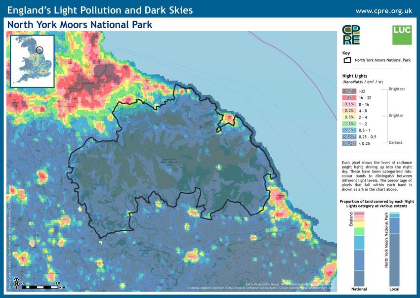
the Northumberland International Dark Sky Park is given as a successful example of the
positive benefits of protecting the dark skies found in National Parks.
2.2 The National Planning Policy Framework (2018) refers to tranquillity in Paragraph 180,
saying that planning policies and decisions should aim to “identify and protect areas of
tranquillity which have remained relatively undisturbed by noise and are prized for their
recreational and amenity value for this reason”. It is up to individual planning authorities to
decide how to identify and protect tranquil areas. The importance of controlling light
pollution is covered in Paragraph 180 which says that planning policies and decisions
should “limit the impact of light pollution from artificial light on local amenity, intrinsically
dark landscapes and nature conservation.”
2.3 Conserving and enhancing the North York Moors’ special qualities are a key part of the
vision for the National Park set out in the North York Moors National Park Management
Plan. One of the Plan’s aims is that the North York Moors will continue to be a place of
tranquillity, remoteness and dark night skies, providing opportunities for spiritual
refreshment. The Plan has six policies that are designed to deliver this aim, three of which
depend on supporting planning policies for their implementation:
E19: Existing tranquil areas will be protected and expanded where possible.
E20: Dark skies will be protected and improved. New development in the National
Park will not cause unacceptable light or noise pollution.
E24: The impacts of traffic on the tranquillity of the National Park will be minimised
and alternatives to the private car will be promoted.
3. Why introduce new policies?
3.1 The National Park’s special qualities are currently protected in Core Policy A, ‘Delivering
National Park purposes and Sustainable Development’ of the 2008 Core Strategy and
Development Policies Document.. The policy gives priority to ‘Providing a scale of
development and level of activity that will not have an unacceptable impact on the wider
landscape or the quiet enjoyment, peace and tranquillity of the Park, nor detract from the
quality of life of local residents or the experience of visitors’. The Authority does not have
specific Tranquillity, Remoteness or Dark Skies development management policies but
protection of these qualities is covered by DP1, ‘Environmental Protection’ which seeks to
conserve and enhance the special qualities of the National Park by permitting development
only where there will not be unacceptable adverse impacts, including unacceptable levels
of noise, vibration, activity or light pollution.
3.2 In recent years conserving the North York Moors’ special qualities has become increasingly
challenging. The Authority has had to consider how best to deal with proposals for large
scale industrial development, substantial tourism schemes and pressures for housing
development in Helmsley and the larger villages of the National Park. Such developments
bring increased levels of noise and light pollution as well as disturbance from traffic and
general activity levels, all of which threaten the National Park’s tranquillity, sense of
remoteness and dark night skies. Changing farming methods lead to demand for larger
scale agricultural buildings which can alter the character of a moorland valley and
pressures to intensify grouse and pheasant shooting activities can also change the
character of open moorland areas. Further pressures come from the demand for windfarms
outside but close to the National Park and from shale gas exploitation. Within the National
Park, the increase in visitor numbers needs to be managed with care to avoid spoiling the
special qualities of the North York Moors which draw visitors in the first place. Some places
are under particular threat, for example, areas around tourism ‘honeypot’ locations such as
Goathland, Rosedale Abbey and Dalby Forest. The coastal strip could also be a vulnerable
area if there is pressure for further development in connection with the new Woodsmith
Mine and the push for economic growth in Scarborough and Teesside.
Topic Paper - Tranquillity, Remoteness and Dark Night Skies policies – July 2018. 5
3.3 In order to deal effectively with these challenges, the Authority wishes to strengthen its
policy position and introduce specific policies in the new Local Plan covering the three
special qualities that affect the way people experience the National Park. The new Local
Plan must find ways to support appropriate development that will enable local communities
and the local economy to thrive while at the same time conserving the environment and the
special sense of place that was the reason for the National Park designation. More detailed
policies covering tranquillity, the sense of remoteness and dark skies at night would:
Conserve and, where possible, enhance these qualities to ensure their retention for
future generations;
Support and deliver the policies in the Management Plan by giving clear control over
potentially harmful development;
Raise awareness of the value of these special qualities and ensure that they are
specifically assessed and given appropriate weight as part of the development
management process.
4. Tranquillity
4.1 Defining tranquillity: Tranquillity can be defined as a state of peace and calm which is
influenced by what people see and experience around them. It is most often found in places
dominated by natural habitats which are free from human structures and the disturbances
of traffic and busy daily activities. However, villages and groups of buildings can also be
tranquil, especially where the built environment is pleasing and activity levels are low.
Tranquil places usually include natural elements such as trees, grass or water. Such places
foster a sense of ‘belonging’ and being connected to nature and history and are important
to people’s wellbeing. Places where people feel tranquil are increasingly rare in the modern
world and are highly valued. National Parks have an important role to play in looking after
tranquil places so the conservation and enhancement of tranquillity in the North York Moors
is an important objective for the new Local Plan.
4.2 Tranquillity in the North York Moors: Discussions of tranquillity generally refer to positive
factors which contribute to tranquillity and negative ones which detract from it (often the
opposite of a positive factor). When considering attributes which contribute to tranquillity in
the North York Moors, officers considered that the following were important:
Openness or remoteness
Presence of natural or semi-natural habitats
Extensive/high quality views
Dark skies at night
Absence of disturbance from noise and activity
Absence of major built features including roads, overhead electricity cables,
industrial structures
Natural sounds such as birdsong, water, waves or breezes.
4.3 CPRE Tranquillity mapping: The Campaign to Protect Rural England (CPRE) carried out
the first national tranquillity mapping exercise in 1996 and this was updated by Northumbria
University to produce CPRE’s 2007 Tranquillity Map, reproduced at Appendix 1. The map
covers the whole of England and shows ‘relative’ tranquillity for 500m x500m grid squares
with green areas being the most tranquil, yellow less tranquil and red the least tranquil. The
tranquillity scores for individual squares were generated by a modelling process which
assessed and gave weightings to a range of factors based on what could be heard and
seen at each location. Positive factors included attributes such as remote and wild
landscapes, rivers and native trees; negative factors included attributes such as urban
development, powerlines and traffic noise.
4.4 The map showed that that the North York Moors is one of the most tranquil areas in
England, even compared to other National Parks. Almost 90% of the North York Moors
Topic Paper - Tranquillity, Remoteness and Dark Night Skies policies – July 2018. 6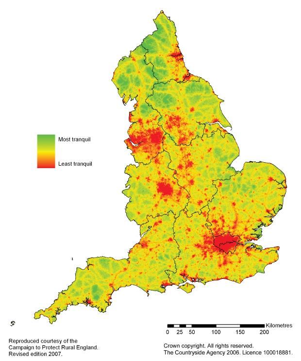
National Park could be classed as relatively tranquil. Figure 1 shows how tranquillity is
        graded across the area with the most tranquil areas being the moorland and dales and less
        tranquil areas broadly correlated to the road network and the fringes of the Park which are
        close to urban areas. The presence of native trees and woodland, particularly in the south
        of the National Park, contributes to the sense of tranquillity in these locations.

                Figure 1 - Relative Tranquillity in the North York Moors National Park (CPRE)

        Source: National Tranquillity Mapping Data 2007 developed for Campaign to Protect Rural England and Natural
        England by Northumbria University. OS Licence number 1000018881

4.5     Should the CPRE Tranquillity map be updated? As part of the preparatory work for the
        Local Plan the Authority considered whether to commission an updated tranquillity map for
        the North York Moors. Other organisations have undertaken such exercises either updating
        the 2007 CPRE map or preparing new versions for their area using different mapping
        approaches2. The mapping options considered by the Authority were:

              a) Option 1: Commission consultants to update the Tranquillity Map using the same
                 techniques that were used for the 2007 CPRE map. This would be a major exercise
                 covering the whole of the National Park with outside consultants brought in to agree
                 the range of positive and negative tranquillity factors and carry out the modelling.
2
 South Downs National Park Authority Tranquillity Study 2017; New Forest Tranquil Areas Map 2015;
Scottish Natural Heritage Map of Wild Land Areas 2014.

Topic Paper - Tranquillity, Remoteness and Dark Night Skies policies – July 2018.                               7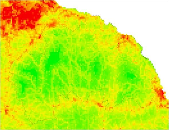
The main reservation with this option was how useful a base for policy the updated
                 map would be. The CPRE approach produces relative rather than absolute scores
                 and the method works best across a wide geographical area. This is seen in the
                 map at Appendix 1 which shows that the North York Moors as a whole is very
                 tranquil compared to elsewhere in the country. It is less useful at a smaller
                 geographical scale, in effect simply showing that there is a split of tranquil and very
                 tranquil areas in the North York Moors.

              b) Option 2: Undertake a ‘ground truthing’ exercise, with volunteers or consultants
                 assessing and giving weightings to various tranquillity criteria in an ‘on the ground’
                 survey in a variety of locations across the National Park. This would also be a time
                 consuming and potentially expensive option although the resultant map would
                 provide a robust and up-to-date evidence base for tranquillity in the National Park.
                 However, given the general absence of major roads, airfields, towns and large-scale
                 infrastructure across the area, there is a danger that it could simply confirm what is
                 already known i.e. that the North York Moors is a tranquil area generally with
                 relatively little variation between places.

              c) Option 3: Carry out a public or visitor survey asking people which places they
                 consider to be the most tranquil. This was rejected as being too subjective an
                 approach. Perceptions of tranquillity are relative and depend on what people value
                 and how their experience of the National Park compares with the place where they
                 spend most time. A visitor from a major city may see one of the North York Moors
                 tourism hotspots as tranquil compared to home and may not have an accurate view
                 of relative tranquillity across the whole of the National Park.

              d) Option 4: Map tranquillity ‘factors’ in house using the Authority’s Geographic
                 Information System (GIS). This option was explored in some detail and a preliminary
                 Tranquillity Indicators Map was prepared. The exercise involved identifying a series
                 of features which either contribute to or detract from people’s experience of
                 tranquillity for which spatial data were available on the Authority’s GIS mapping
                 facility including moorland, woodland, roads and railway lines. This produced a map
                 of tranquillity indicators rather than tranquillity per se and it was not taken any further
                 because it was not considered to be sufficiently robust to use in connection with any
                 proposed new policy.

4.6     It is clear that any attempt to make a detailed spatial representation of tranquillity is
        complex. Many different elements, some positive, some negative combine to determine
        whether a particular place is perceived as tranquil and since tranquillity is a quality
        experienced by people, different people will have different views of the kind of places they
        find tranquil. This makes any objective assessment of tranquillity complicated. After some
        deliberation and discussion of the ways in which a tranquillity policy may be framed, it was
        decided that the cost and time involved in producing an updated tranquillity map were not
        justified particularly since a map-based approach was not the preferred way forward for a
        new tranquillity policy (see paras 4.10–4.12 below).

4.7     Developing a policy to conserve tranquillity: The Authority’s consideration of how to
        frame a new policy is based on the principle that tranquillity is an asset worth protecting
        wherever it occurs. The most striking feature of the CPRE tranquillity map is that, in
        comparison with areas beyond the Park boundary, the whole of the National Park is
        relatively tranquil. The new policy should not just protect the most tranquil places but should
        conserve and where possible enhance tranquillity throughout the National Park.

4.8     It is recognised that some of the strongest detractors from tranquillity are beyond the
        control of the planning system, for example the noise from motorbikes travelling through the
        Park and military aircraft carrying out low-flying training or practice exercises. However,
        planning does have a role to play. Most existing tranquil areas are already protected by
        policies which do not allow development in open countryside except in certain specific

Topic Paper - Tranquillity, Remoteness and Dark Night Skies policies – July 2018.                       8
circumstances and by strict environmental regulations if they are areas of protected
        habitats. It seems counter-intuitive to suggest that any form of development could enhance
        or extend tranquil areas and where new development is concerned, the focus is likely to be
        on minimising features which would have a harmful impact on tranquillity (noise, activity
        levels, obtrusive structures, external lighting) and requiring mitigating measures to offset
        the impact of the development on tranquillity in the surrounding area. Nevertheless, good
        design and a careful approach to landscaping and planting can enhance tranquillity,
        particularly if it improves an existing untidy area.

4.9     It is also important to recognise that the aim to conserve and enhance tranquillity may be in
        conflict with other objectives in the draft Local Plan, for instance those which encourage
        new employment opportunities or support the installation of better communications
        infrastructure. As with all planning decisions there will be a balance to be struck between
        competing objectives.

4.10    Tranquillity policy – preferred option and alternative approaches: The Authority’s
        preferred option is to introduce a criteria-based policy that would apply throughout the
        National Park. The proposed policy states that development proposals will only be
        permitted where there will not be unacceptable harm to the tranquillity of the surrounding
        area. Under the policy, all proposals would be assessed in relation to their impact on
        tranquillity and the criteria to be considered are listed in the policy: visual intrusion, noise
        and activity levels, traffic generation, presence of natural and semi-natural habitats and
        presence of historic assets. Development management staff would consider potential harm
        or benefits to tranquillity in the surrounding area, taking into account direct, indirect and
        cumulative effects and using professional judgement to assess the impacts. Development
        proposals at the edge of a settlement would require particular care to ensure that changes
        do not harm the tranquillity of the surrounding countryside. It is not suggested that
        applicants would be required to submit additional ‘tranquillity’ documentation on a routine
        basis but, depending on the proposal, information on noise levels or anticipated traffic
        movements may be needed.

4.11    Alternative policy approaches that the Authority has considered are in the following table:

          Preferred option                                    Pros/Cons

          Introduce a criteria based tranquillity             Straightforward approach that ensures
          policy that would apply throughout the              specific assessment of tranquillity is made
          National Park.                                      in relation to all development proposals
                                                              and recognises that the whole of the
                                                              National Park is tranquil in comparison
                                                              with areas beyond its boundary.

          Alternative approaches                              Pros/Cons

          Keep the existing approach as contained             Would not raise the profile of tranquillity in
          in Core Policy A and do not introduce a             the development management process
          specific tranquillity policy.                       nor strengthen the policy position for the
                                                              future.

          Introduce a spatial tranquillity policy             Practical difficulties updating Tranquillity
          based on zones identified within an                 Map. Concern that policy based on
          updated Tranquillity Map of the National            Tranquillity zones implies some areas of
          Park, setting out a different approach to           the National Park are more highly valued
          development in different zones.                     than others. Would lead to pressures on
                                                              areas identified as least tranquil. Any
                                                              attempt to weight tranquillity within the
                                                              National Park risks losing the message

Topic Paper - Tranquillity, Remoteness and Dark Night Skies policies – July 2018.                              9
that almost all the National Park is,
relatively speaking, tranquil.
Adopt a combined approach using a More complex approach but still ensures
criteria based policy that would give all development proposals assessed in
additional protection to remote areas. relation to tranquillity. Recognition that
remote areas are among the most tranquil
in the National Park and may be
appropriate if remote areas policy is
supported.
5. A strong feeling of remoteness
5.1 Remote undeveloped areas of open moorland and woodland are among the most tranquil
places in the North York Moors and, without the intrusion of man-made structures, they
have a quality of ‘wildness’ not found in the farmed countryside and urban areas outside the
National Park boundary. A strong feeling of remoteness is a special quality of the National
Park and is an important feature of the North York Moors because of the extensive tracts of
moorland and forest and the patchwork of very small and dispersed settlements. These
remote locations generate a sense of getting away from the stresses of modern life and
feeling close to nature. They are a finite resource which, once lost, cannot be regained and
the Authority considers it appropriate for them to be protected.
5.2 The Authority’s consideration of remoteness flowed from discussions about the practical
difficulties of mapping tranquillity and the search for an alternative way to give a spatial
dimension to the ‘perceptual’ qualities of the National Park. The characteristics associated
with tranquillity - presence of natural or semi-natural habitats, lack of noise, activities and
man-made structures – are found to a high degree in remote areas but tranquillity and
remoteness are distinct qualities and they are separate planning interests. Remoteness is
also distinct from the natural beauty of the landscape which is recognised in the National
Park’s Section 3 map.3
5.3 The type of development proposal that might come forward in remote areas would be works
to roads, tracks, overhead cables, masts, car parks or facilities requested by the Forestry
Commission or moorland estate owners. The intensification of grouse shooting in recent
years has led to demands for improvements to tracks and huts in open moorland. There are
also potential future development large scale development pressures which by their nature
may need remote locations e.g. reservoir creation, mining or other mineral extraction or
exploration activity, energy proposals or military structures or uses. It is important that the
new Local Plan should provide an appropriate policy framework for considering such
development proposals.
5.4 Defining remoteness: Remoteness can be defined as the state of being located far away
from everyone or everything else and can be objectively measured as distance away from
places where people live and work. It is therefore simpler to produce a spatial
representation of remoteness that would be sufficiently robust to be used in a new policy.
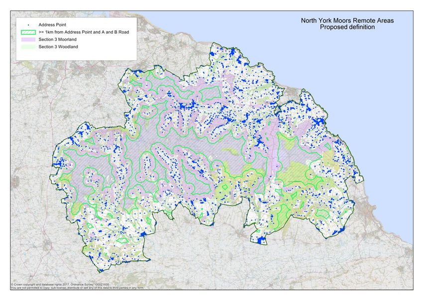
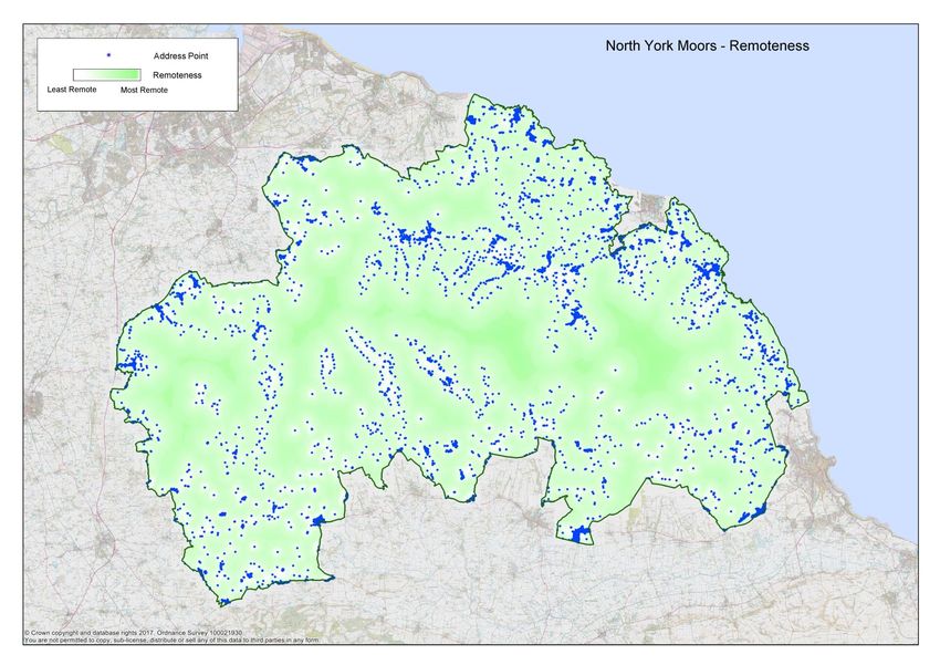
5.5 The Authority has considered three alternative ways of mapping remote areas within the
National Park:
a) Defining remote areas as places at least 1km away from the nearest postal address
point or A or B class road;
3
Section 3 of the Wildlife and Countryside (Amendment) Act 1985 gives National Park Authorities a
responsibility to prepare a map showing areas of mountain, moor, heath, woodland, down, cliff or foreshore
which it considers particularly important to conserve because of their natural beauty.
Topic Paper - Tranquillity, Remoteness and Dark Night Skies policies – July 2018. 10b) Defining remote areas as places at least 1km away from settlements with more than
5 address points;
c) Using graduated shading to represent remoteness.
5.6 With the first alternative the remote area would include areas of open moor, woodland and
other landscape types, mostly in the central part of the Park, where by definition there are
no villages or scattered farmsteads. Figure 2 below shows the areas that would be
identified, with Section 3 moorland and woodland areas also shown for comparison. With
this alternative, the remote area covers 290 kms2 or 20% of the National Park.
5.7 One comment on this approach was that dale head areas, which often have a strong sense
of remoteness, would not be included within the remote areas boundary because they have
a scattering of isolated farmsteads. The second alternative was put forward to overcome
this concern by including isolated farmsteads and very small groups of buildings in the
remote area. Figure 3 below shows this approach which would result in a large proportion
of National Park - 982 kms2 or 68% - being included with the remote area designation.
5.8 The third alternative would represent remoteness by graduated shading rather than as a
designated area within a defined line. A map would show greater and lesser degrees of
remoteness across the whole of the National Park. Figure 4 below shows how remoteness
would be represented across the National Park using this approach.
5.9 Larger scale version of all the maps can be seen on the Authority’s website at:
www.northyorkmoors.org.uk/localplanspecialqualities
Topic Paper - Tranquillity, Remoteness and Dark Night Skies policies – July 2018. 11Figure 2 – North York Moors Remote Areas using definition that excludes isolated farmsteads Topic Paper - Tranquillity, Remoteness and Dark Night Skies policies – July 2018. 12
Figure 3 – North York Moors Remote Areas using definition that includes isolated farmsteads

Topic Paper - Tranquillity, Remoteness and Dark Night Skies policies – July 2018.                 13
Figure 4 – North York Moors – Remoteness represented by graduated shading.

Topic Paper - Tranquillity, Remoteness and Dark Night Skies policies – July 2018.                14
5.14    Developing a policy to conserve remoteness: The different approaches to mapping remote
        areas have different implications for the way a policy to conserve remoteness would be framed.
        The advantage of the first alternative (defining remote areas as places at least 1km away from
        the nearest postal address point or A or B class road) is that a restrictive approach to
        development that would protect the area could be consistently applied within it. There could be
        a clear policy wording limiting development to that which is essential for environmental
        conservation or agricultural or forestry purposes and legitimate development proposals that may
        be needed to sustain existing families and small farm businesses would not be affected.

5.16    With the second alternative, exceptions to a restrictive policy approach would need to be made
        in order to continue to support those living and working in farmsteads within the remote area.
        The policy wording would limit development to essential environmental conservation or
        agricultural or forestry purposes except for cases where development is required to meet the
        essential needs of existing households, farms or businesses. This would give those living or
        working in the designated area access to policies that apply more generally in open countryside
        locations, permitting development such as new agricultural buildings, changes of use, house
        extensions or small camp sites which may be requested as a farm diversification proposal.

5.17    With the third alternative the policy wording would be more general, saying that all development
        proposals would be considered in relation to their impact on the character of remote areas,
        taking into account the scale, nature and location of the proposal.

5.18    It is important to note that introducing a remote areas designation would not change the position
        of these places in the settlement hierarchy - remote areas would still be regarded as open
        countryside but with an additional level of policy protection recognising their remoteness as a
        public interest. Also, all Section 3 areas, whether or not they were within the remote area
        boundary, would be protected for their natural beauty through landscape policy and for their
        habitats through the wildlife and biodiversity policy. This recognises the fact that not all remote
        areas are moorland and not all Section 3 moorland is remote.

5.19    Remoteness policy – preferred option and alternative approaches: The Authority’s
        preferred option is to introduce a policy that development will only be permitted in remote areas
        where it is essential for environmental conservation, agricultural or forestry management
        purposes with remote areas defined as places at least 1km away from the nearest postal
        address point or A or B class road. Applicants would also have to demonstrate that there were
        no suitable alternative locations outside the remote area and that appropriate mitigation
        measures would be taken to minimise any harmful impact on tranquillity.

5.20    The following table shows how different types of development would be treated under the
        proposed policy, unless any specific material planning considerations of the particular case
        outweighed the policy position.

          Development proposal                         Open countryside             Open countryside
                                                       within Remote Area           outside Remote
                                                       boundary                     Area boundary

          Communications mast                          Refuse                       Support if appropriate

          Overhead cable                               Refuse                       Support if appropriate

          Livestock handling pen (where                Support if essential and     Supported if
          permission is needed)                        small scale                  appropriate

Topic Paper - Tranquillity, Remoteness and Dark Night Skies policies – July 2018.                            15
Development proposal Open countryside Open countryside
within Remote Area outside Remote
boundary Area boundary
New agricultural or forestry track Refuse Support if essential
Improvement to existing Support if essential and Support if essential
agricultural or forestry track appropriate and appropriate
Public art4 Refuse Support if appropriate
Recreational or business Refuse Support if appropriate
development
5.21 The advantages and disadvantages of the preferred option as well as the alternative policy
approaches that the Authority has considered are summarised below:
Preferred option Pros/Cons
Introduce a policy permitting development Strong protection for remote areas which
in remote areas where it is essential for can be consistently applied in a clearly
environmental conservation, agricultural or defined area.
forestry purposes. Mapping definition of
remote areas to exclude isolated
farmsteads (Figure 2).
Alternative approaches Pros/Cons
Keep the existing approach as contained Would not recognise the specific value of
in Core Policy A and do not introduce a remote areas within the National Park.
specific remote areas policy.
Introduce a policy that development will Includes dale heads in remote areas
only be permitted in remote areas where it designation. The need to allow exceptions
is essential for environmental to restrictive approach to development
conservation, agricultural or forestry (particularly for essential agricultural uses)
purposes. Mapping definition of remote undermines the policy and indeed the very
areas to include isolated farmsteads concept of “remoteness” – little difference
(Figure 3). between policy applied to remote areas and
wider open countryside.
Introduce a policy that all development More flexibility regarding how restrictive an
proposals would be considered in relation approach to development should be taken
to their impact on the character of remote in individual cases, based on the location
areas – based on map which uses and specific circumstances of the proposal.
graduated shading to represent
Less certainty for applicants and land
remoteness (Figure 4).
owners.
Weaker protection for remote areas.
4
The ‘Seated Figure’ at Castleton Rigg is c. 0.3 km from a farm (there are seven farms and three houses within one kilometre) and 1.7 km
from Westerdale.
Topic Paper - Tranquillity, Remoteness and Dark Night Skies policies – July 2018. 166. Dark night skies
6.1 Dark skies at night are increasingly rare in modern Britain and the protected landscapes of
national parks where external light levels are low are therefore an important national resource.
Dark skies are a particular feature of the North York Moors because of the large areas of open
countryside with little or very sparse settlement and low levels of air pollution. The ability to
experience dark skies is enhanced by the open nature of the moorland skyline, the presence of
several large forest plantations within the Park and the dark expanse of the North Sea to the
east of the moorland plateau. These natural characteristics combine so that it is possible to
experience dark and starry skies from many locations within the National Park.
6.2 As well as being an intrinsic part of the quality of the National Park landscape, dark skies at
night are important for many wildlife species e.g. bats, moths and nightjar and help maintain
biodiversity within the National Park. They are also important for recreation – there is a growing
interest in star gazing which in turn has benefits for local communities and the local tourism
economy. There are now three ‘Dark Sky Discovery’ sites in the National Park at Sutton Bank,
Dalby Forest and the Moors National Park Centre at Danby.
6.3 Studies into light pollution and dark night skies: The Campaign to Protect Rural England
(CPRE) has been at the forefront of campaigns to reduce light pollution and protect and
enhance dark night skies. CPRE published satellite maps in 1993 and 2000 which showed that
light pollution had increased by 26% in England over that period. In 2009 a Royal Commission
on Environmental Pollution report, Artificial Light in the Environment5 defined light pollution as
the experience of light in the wrong place or at the wrong time and identified five types of light
pollution:
Glare: The excessive contrast between bright and dark areas in one’s field of view;
Light trespass: Unwanted light, for example from adjacent properties and activities;
Light clutter: The excessive grouping of lights, for example in roadside advertising;
Light profligacy: Over-illumination which wastes energy and money;
Sky glow: A combination of reflected and refracted light from the atmosphere. This is
the most pervasive form of light pollution and can affect areas many miles from the
original light source.
It recommended that there should be explicit consideration of light in planning policy and that
Authorities responsible for managing protected areas should try to eliminate unnecessary
outdoor light and have better design and management of light which cannot be eliminated.
6.4 More recently, CPRE has published the ‘Night Blight’ report which includes a new map based
on satellite images collected in September 20156. The map shows the different amounts of light
spilling up into the night sky across the country and is available on line on an ‘OpenStreetMap’
base7. The national map at Appendix 2 shows that the North York Moors was one of the areas
in the country that was most free of light pollution with 92% of the skies in the two darkest
categories. Teesside is a major source of light pollution on the northwest escarpment and areas
close to urban centres just beyond the National Park boundary, for example Whitby,
Scarborough and Pickering are also affected by light pollution. There is just one significant
source of light pollution within the central area of the National Park at RAF Flylingdales. The
North York Moors section of the map is reproduced in Figure 5 below.
5
The Royal Commission on Environmental Pollution (2009) Artificial Light in the Environment. The Stationery
Office Ltd, London
6
‘Night Blight: Mapping England’s Light Pollution and Dark Skies’ CPRE 2016
7
http://nightblight.cpre.org.uk/
Topic Paper - Tranquillity, Remoteness and Dark Night Skies policies – July 2018. 17Figure 5 – North York Moors – CPRE Light Pollution and Dark Skies Mapping.
6.5 Developing a policy to conserve dark night skies: In developing a new policy, the Authority
is recognising dark night skies as an amenity worth protecting. Many aspects of the Authority’s
work play a part in conserving and enhancing dark skies but planning is a key area which can
influence the quality of night skies. It can do this by:
a) Refusing development in inappropriate locations – the darkest skies are found in open
countryside and existing policies already protect such areas from new development
unless there are exceptional circumstances;
b) Controlling the amount and type of external lighting on new developments to ensure that
light is only provided when and where it is essential for safety and security. Where it is
needed, certain types and standards of fitting, e.g. ‘fully shielded’ luminaries, can be
required which minimise upward light spill and planning conditions can be imposed to
control the timing of external lighting;
c) Liaising with the highway authority to ensure that street lighting associated with new
developments is appropriate;
d) Ensuring that the design of new buildings avoids light spill from internal areas;
e) When applications come in for works to existing buildings, encouraging applicants to
improve any existing external lighting by signposting them to relevant advice and, if
available, grant funding;
f) Being aware of indirect impacts of new development, e.g. lights from traffic accessing a
building at night;
g) Ensuring that neighbouring planning authorities are aware of the potentially harmful
impact of external lighting from developments just beyond the National Park boundary.
6.6 Requiring external lighting to meet appropriate standards is central to any new policy. Although
the UK has no regulatory body overseeing external lighting, professional institutions provide
Topic Paper - Tranquillity, Remoteness and Dark Night Skies policies – July 2018. 18advice and recommendations. In 1993 the Institution of Lighting Professionals (ILP) produced
guidelines which identified different environmental zones based on night-time ambient light.
ILP Environmental Zones
Zone Surrounding Lighting Environment Examples
E0 Protected Dark UNESCO Starlight Reserves,
IDA Dark Sky Parks
E1 Natural Intrinsically dark National Parks, Areas of
Outstanding Natural Beauty
etc.
E2 Rural Low district brightness Village or relatively dark outer
suburban locations
E3 Suburban Medium district brightness Small town centres or
suburban locations
E4 Urban High district brightness Town/city centres with high
levels of night-time activity
The guidelines8 recommend differing degrees of ‘stray’ light control for each of the classified
zones. All National Parks are placed in Environmental Zone E1.
6.7 The ILP guidelines are well established and provide a clear set of standards that could be used
to assess external lighting on proposed new developments. However, the Authority is also
preparing a Dark Skies Audit and Management Plan as part of a proposal to apply for the North
York Moors to be recognised by the international Dark Sky Places programme. This would set
out specific standards for external lighting within the National Park and, once adopted, could be
incorporated into a new dark skies planning policy as an alternative to the ILP guidelines.
6.8 The Authority has considered whether to apply specific requirements for external lighting
throughout the National Park or only in those locations where skies are currently darkest.
Setting standards across the whole of the National Park would recognise that light spill can
travel a considerable distance and the widest possible control of external lighting is needed to
protect existing dark sky locations. However, a spatial approach could offer more flexibility and
allow for more strict controls in the most sensitive locations in open countryside. The North York
Moors does not have an identified dark sky ‘core’ area but the CPRE map shows that there is a
considerable overlap between the darkest parts of the National Park and the proposed remote
areas described in section 5 above. It would therefore be possible to adopt a spatial approach
which distinguished between remote areas, open countryside and locations within settlements.
6.9 Dark night skies policy – preferred option and alternative approaches: The Authority’s
preferred option is to introduce a policy requiring all development proposals to minimise light
spillage through good design and lighting management. No external lighting would be permitted
in remote areas and in open countryside locations applicants would need to demonstrate that
new external lighting is essential for safety or security reasons. In village locations, applicants
would need to demonstrate that it is essential for safety, security or community reasons. All
lighting installations associated with new development would need to meet the Authority’s
adopted standards (initially the ILP guidelines for outdoor lighting in Environmental Zone 1 as
8
Updated version: ‘Guidance Notes for the Reduction of Obtrusive Light GN01:2011’ Institution of Professional
Lighting 2011
Topic Paper - Tranquillity, Remoteness and Dark Night Skies policies – July 2018. 19set out in Appendix 3). Where proposals involve works to an existing building, applicants would
be encouraged to bring existing lighting installations up to the same standard.
6.10 The advantages and disadvantages of the preferred option as well as the alternative policy
approaches that the Authority has considered are summarised below:
Preferred option Pros/Cons
Introduce a spatial policy with no external Sets a recognised standard for all new external
lighting permitted in remote areas. In open lighting installations throughout the National
countryside new external lighting must be Park.
essential for safety or security reasons. In
Gives extra protection to remote areas where
settlements new external lighting must be
the darkest skies are experienced.
essential for safety, security or community
reasons. Recognises there may be community needs for
external lighting within villages.
All installations to meet ILP Guidelines for
Environmental Zone E1.
Alternative approaches Pros/Cons
Keep the existing approach as contained Would not promote conservation and
in Core Policy A and do not introduce a enhancement of dark night skies in the National
specific dark night skies policy. Park nor strengthen the policy position for the
future.
Introduce a non-spatial policy which would A simpler approach but would not give additional
permit external lighting in all locations protection to areas where the darkest skies are
where required for safety, security or experienced. Not consistent with aim for the
community reasons provided it meets the National Park to be recognised under Dark Sky
ILP Guidelines for Environmental Zone E1. Places programme.
7. Next Steps
7.1 This topic paper has been produced to support the ‘Preferred options’ consultation (July 2018).
Please let us have your views on the proposed policies to conserve the National Park special
qualities of tranquillity, a strong sense of remoteness and dark night skies by responding to the
consultation questionnaire available at ………………..The responses received will inform the
Publication draft of the new Local Plan which will be the subject of a final stage of consultation
early in 2019.
7.2 If you would like to be kept in touch about the new Local Plan please complete the Mailing List
Form if you are not already being notified or email us at
policy@northyorkmoors.org.uk
Topic Paper - Tranquillity, Remoteness and Dark Night Skies policies – July 2018. 20Appendix 1: CPRE National Tranquillity Map. Topic Paper - Tranquillity, Remoteness and Dark Night Skies policies – July 2018. 21
Appendix 2: CPRE ‘Night Blight’ Map of Light Pollution and Dark
Skies

© Natural England copyright 2016. Contains Ordnance Survey data © Crown copyright and database right 2016
Earth Observation Group, NOAA National Geophysical Data Center. Developed by LUC

Topic Paper - Tranquillity, Remoteness and Dark Night Skies policies – July 2018.                           22
Appendix 3: Extract from ILP Guidance Notes for the Reduction of
Obtrusive Light
DESIGN GUIDANCE

The following limitations may be supplemented or replaced by a LPA’s own planning guidance for exterior
lighting installations. As lighting design is not as simple as it may seem, you are advised to consult and/or work
with a professional lighting designer before installing any exterior lighting.

Table 2 – Obtrusive Light Limitations for Exterior Lighting Installations – General Observers

Environment Sky Glow             Light Intrusion (into           Luminaire Intensity I           Building
al Zone     ULR [Max             Windows) Ev [lux] (2)           [candelas] (3)                  Luminance
            %](1)                                                                                Pre-curfew
                                                                                                 (4)
                                 Precurfew       Postcurfew      Precurfew          Postcurfew   Average, L
                                                                                                 [cd/m2 ]
E0               0               0               0               0                  0            0
E1               0               2               0 ( 1*)         2,500              0            0
E2               2.5             5               1               7,500              500          5
E3               5.0             10              2               10,000             1,000        10
E4               15              25              5               25,000             2,500        25

ULR = Upward Light Ratio of the Installation is the maximum permitted percentage of luminaire flux that goes
directly into the sky. Ev = Vertical Illuminance in Lux - measured flat on the glazing at the centre of the window. I
= Light Intensity in Candelas (cd) L = Luminance in Candelas per Square Metre (cd/m2 ) Curfew = the time after
which stricter requirements (for the control of obtrusive light) will apply; often a condition of use of lighting
applied by the local planning authority. If not otherwise stated - 23.00hrs is suggested. * = Permitted only from
Public road lighting installations

(1)Upward Light Ratio – Some lighting schemes will require the deliberate and careful use of upward light, e.g.
ground recessed luminaires, ground mounted floodlights, festive lighting, to which these limits cannot apply.
However, care should always be taken to minimise any upward waste light by the proper application of suitably
directional luminaires and light controlling attachments.

(2)Light Intrusion (into Windows) – These values are suggested maxima and need to take account of existing
light intrusion at the point of measurement. In the case of road lighting on public highways where building
facades are adjacent to the lit highway, these levels may not be obtainable. In such cases where a specific
complaint has been received, the Highway Authority should endeavour to reduce the light intrusion into the
window down to the post curfew value by fitting a shield, replacing the luminaire, or by varying the lighting
level.

(3)Luminaire Intensity – This applies to each luminaire in the potentially obtrusive direction, outside of the area
being lit. The figures given are for general guidance only and for some sports lighting applications with limited
mounting heights, may be difficult to achieve.

 (4) Building Luminance – This should be limited to avoid over lighting, and related to the general district
brightness. In this reference building luminance is applicable to buildings directly illuminated as a night-time
feature as against the illumination of a building caused by spill light from adjacent luminaires or luminaires fixed
to the building but used to light an adjacent area

Topic Paper - Tranquillity, Remoteness and Dark Night Skies policies – July 2018.                             23
If you would like further information, please contact us:
Planning Policy – policy@northyorkmoors.org.uk
Development Management – planning@northyorkmoors.org.uk
01439 772700
northyorkmoorsnationalpark
@northyorkmoors
The text of this document can be made in large print. Please contact the
Planning Policy team using the contact information above.
North York Moors National Park Authority
The Old Vicarage, Bondgate, Helmsley, York YO62 5BP
Topic Paper - Tranquillity, Remoteness and Dark Night Skies policies – July 2018. 24
01439 772700
www.northyorkmoors.org.ukYou can also read