Investigation of Çankiri City Railway in Scope of Greenway - MDPI
←
→
Page content transcription
If your browser does not render page correctly, please read the page content below
sustainability

Article
Investigation of Çankiri City Railway in Scope of Greenway
Umut Pekin Timur * , Ferhat Özden, Pakize Ece Erzin                           and Özgür Burhan Timur

                                          Landscape Architecture Department, Faculty of Forestry, Cankiri Karatekin University, Cankiri 18100, Turkey;
                                          frht.ozden@gmail.com (F.Ö.); ecerzin@gmail.com (P.E.E.); ozgurtim@hotmail.com (Ö.B.T.)
                                          * Correspondence: umutpt@karatekin.edu.tr; Tel.: +90-376-2122757

                                          Abstract: Nowadays, the importance of greenway applications in planning studies has increased to
                                          meet the increasing environmental problems in cities, the loss of open spaces, and the increasing need
                                          for recreation. The purpose of this study is to evaluate within the scope of the greenway about the
                                          part of 11 km of the Çankırı railway passing through the city center by considering the planning and
                                          design dimension. The research was carried out in four stages: literature review, analysis of natural
                                          and cultural landscape characteristics, preparation of a conceptual plan, and design suggestions. The
                                          area has a straight aspect, the slope is 0–3%, and it is an alluvial structure. It was determined that
                                          there are registered historical buildings, but structural areas are intense. According to plan, a green
                                          area and a bicycle path arrangement was proposed at the side of the railway. Also, along the existing
                                          road routes, a walking or bicycle path was proposed to provide connection between open green areas
                                          in the city. In the design process, appropriate landscape design solutions were developed for the
                                          station area, and it was proposed that street area and some intersection points be pedestrianized.

                                          Keywords: rail with trail; greenway; railway; urban sustainability; open and green areas; recreational
                                          greenway; GIS; CSS; Çankırı


Citation: Pekin Timur, U.; Özden, F.;     1. Introduction
Erzin, P.E.; Timur, Ö.B. Investigation         The urban areas inhabited by the majority of the world population are most appealing
of Çankiri City Railway in Scope of       as settlement areas which offer various opportunities for urban people. But today they also
Greenway. Sustainability 2021, 13,
                                          face many environmental problems due to rapid urbanization, population growth, and
3055. https://doi.org/10.3390/
                                          developments in industrialization. In urban issues, not only those of an environmental
su13063055
                                          dimension stand out but also those at economic and social levels [1]. According to estimates
                                          made by the United Nations and many sources, it has been clearly stated that this tendency
Received: 31 January 2021
                                          will continue throughout this century, and by 2050 70% of the world population will be
Accepted: 7 March 2021
                                          living in cities [2]. Parallel to this, the existing problems in cities will certainly increase.
Published: 11 March 2021
                                          The solution will be possible with the implementation of development plans including
                                          sustainable and holistic approaches.
Publisher’s Note: MDPI stays neutral
with regard to jurisdictional claims in
                                               With environmental, economic, and social benefits, greenways play an important role
published maps and institutional affil-
                                          solving problems that originate in urbanization [3].
iations.
                                               Greenways are linear open spaces such as canals and scenic roads that are set along
                                          the riversides, hillsides, or valleys and converted to a recreational use along the railways.
                                          These linear open spaces connect parks, natural reserves, and cultural or historical sites to
                                          each other and settlements [4].
                                               While public parks are a static concept, the greenways are a concept that allows people
Copyright: © 2021 by the authors.
                                          and wildlife to move in terms of the functioning natural processes by creating a green
Licensee MDPI, Basel, Switzerland.
                                          transportation network [5].
This article is an open access article
distributed under the terms and
                                               Greenways are classified into five grades in terms of their basic characteristics [6].
conditions of the Creative Commons
                                          These features are listed below:
Attribution (CC BY) license (https://     •     Linearity: Their spatial forms are linear, with this feature contributing to recreation
creativecommons.org/licenses/by/                and ecology.
4.0/).

Sustainability 2021, 13, 3055. https://doi.org/10.3390/su13063055                                      https://www.mdpi.com/journal/sustainability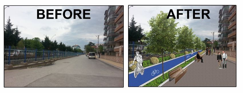
Sustainability 2021, 13, 3055                                                                                            2 of 13

                                •    Linkage: They make connections between life spaces by forming associations with
                                     landscape forms of all scales with their binding qualities.
                                •    Multi-functionality: They can be multifunctional, with ecological, recreational, and
                                     cultural functions.
                                •    Consistency with sustainability: They are consistent with sustainable development
                                     because they are not created only for protection of nature and environment, but also
                                     for people’s use.
                                •    Contribution to landscape planning: They present different spatial strategies depend-
                                     ing on the benefits and features of networked linear open spaces.
                                      These features offer a variety of environmental, economic, and social benefits to urban
                                areas. Environmental benefits can be summarized as conserving and repairing natural
                                areas, protecting and supporting biodiversity, protecting water resources, reducing flood
                                hazards, and providing a living space for plants and animals [7]. Economic benefits:
                                to reduce public investment and private spending, to create an affordable strategy for
                                securing outdoor recreation, to provide tourism attraction, and to increase property value
                                in neighboring areas. Social benefits: to provide protection of historical and cultural
                                resources, to create recreation and alternative transportation facilities, to strengthen social
                                ties, and to increase the quality of life and environmental awareness [8].
                                      Especially with the decline of open space and the need for recreation in the major cities
                                of the US in 1980s, attention has been drawn to the greenways dating back to 1865 [4,9].
                                      Although there are different greenway categories made by different scholars, the most
                                common classification made by [4] into five categories. These are:
                                •    Urban riverside greenways
                                •    Recreational greenways
                                •    Ecologically significant natural corridors
                                •    Scenic and historic routes
                                •    Comprehensive greenway systems or networks
                                      While a significant portion of the greenways are intended for recreation or nature
                                conservation, some of them are planned to cover both purposes. In this context, it is
                                possible to find examples of active or inactive railway routes that are used for recreational
                                greenways in many countries.
                                      Especially after the 19200 s in America with fall of railway use, some routes have been
                                retired. With the increase of the urban population in the country in America, people tried to
                                escape urban pressures through bicycling, horseback riding, and hiking. For this purpose,
                                several old railroad beds have been converted to trails. Congress enacted the Trails Act in
                                1968 to establish a nationwide system of nature trails. In 1983, railway corridors that were
                                out of use for this period were also included. Approximately 141,000 miles are now in use,
                                but it is predicted that another 3000 miles will be abandoned every year through the end of
                                this century [10].
                                      One of the important steps for the use of railway routes as a greenway belongs to
                                the Rails-to-Trails Conservancy (RTC) in America. RTC is a non-profit organization dedi-
                                cated to building a nationwide greenway network from old railway lines and connection
                                corridors to create healthy areas for people. The RTC provides a range of data and demon-
                                stration projects to help raise awareness of railway trails and greenways and improve local
                                and state policies and practices that support railway trails. It has helped develop over
                                31,000 km of railway trails throughout the country and has provided technical support for
                                the construction of potential railways within the greenway for thousands of kilometers [11].
                                      According to the European Greenway Association, the transition from the railway to
                                the greenway in Europe has similarities with the US, and it is usually created for a “safe,
                                continuous and environment-friendly alternative transportation route”. It is possible to
                                find many examples of railway to greenways in America and Europe. For example, in
                                Germany there are 550 greenways [12].
                                      A beautiful and well-known example is the High Line in Manhattan, USA, which has
                                recently been turned off and turned into a greenway. The High Line, which went out of use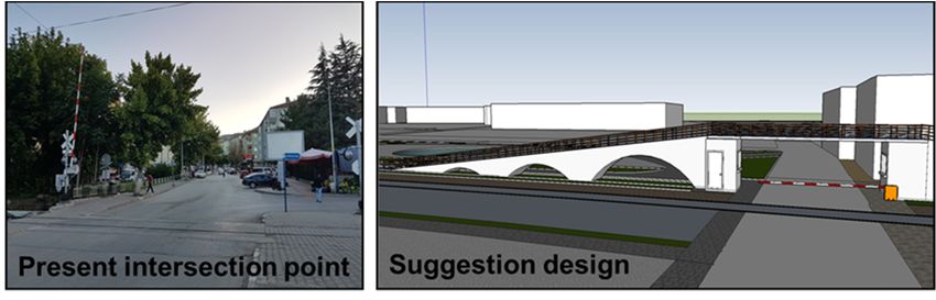
Sustainability 2021, 13, 3055                                                                                            3 of 13

                                in the 1980s, is a railway line that was moved up the road in the 1930s during “the West
                                Side Improvement Project”. In 2006 it was converted into a linear park of about 2.3 km [13].
                                      The RTC organization supports the use of greenways (rail with trail) in active railway
                                corridors. This usage is safe, widespread, and increasing in number day by day. Clarion-
                                Little Toby Creek Trail, Lehigh Gorge State Park Trail, Richmond Greenway, Frisco Trail,
                                and Charlotte Trolley Trail are examples of this usage.
                                      An example of an active railway is the Richmond Greenway in California. The 18-mile
                                rail-trail (2 mile rail with trail) meanders along the wild and scenic Clarion River and
                                Little Toby Creek through Elk and Jefferson counties between the charming small towns of
                                Ridgway and Brockway [14].
                                      The railway route greenways, which are both converted from the unused and actively
                                used railway to the greenway, serve many purposes. The research that RTC conducted on
                                88 active railway-route greenways in current use in 33 different states of the US revealed
                                that all trails were open to pedestrian use while 95% permitted bicycle use and most other
                                non-motorized vehicles (skates, skateboards) [11].
                                      The Context Sensitive Solution (CSS) criteria should also be taken into consideration
                                in planning studies because greenways provide an alternative transport corridor for urban
                                people. CSS, which connects the lands and settlements where streets, roads, and highways
                                pass, is a theoretical and practical interdisciplinary approach that, by paying attention to
                                the beauty of the landscape and protecting natural, historical, and aesthetic areas, ensures
                                environmental sustainability [15,16].
                                      In this context, the railway line in active use passing through the city center of Çankırı
                                is seen as valuable by virtue of its linearity and its central position. The aim of this study
                                is to plan and design about 11 km part of Çankırı railway passing through the city center
                                within the scope of greenway. In the conceptual plan created in line with the principles
                                of greenway planning, recreational greenways that will allow pedestrian and bicycle use
                                were proposed for the city, considering almost no transportation options other than cars
                                and public transportation, and almost no areas for bicycle use. CSS criteria were taken into
                                consideration for providing transportation connections in the plan. According to this, a
                                green area and a bicycle path arrangement was proposed at the side of the railway. Also, in
                                the existing road routes, walking or bicycle paths were proposed to provide connections
                                between open green areas in the city. In the design process, appropriate landscape design
                                solutions were developed for the station area, also street areas and some intersection points
                                were proposed to be pedestrianized.

                                2. Materials and Methods
                                      The main material of the study is the 11,691 m railway line periphery extending
                                between Yaren Gate and Kastamonu Road-New Road connection in Çankırı City and city
                                center (Figure 1).
                                      Çankırı city lies between 40◦ 300 and 41◦ north latitudes and 32◦ 300 and 34◦ east
                                longitudes in the northwestern part of Central Anatolia. Kastamonu and Zonguldak lie
                                to the north of the city, Bolu to the west, Ankara to the south, and Çorum to the east;
                                the surface area is 2210 km2 and the sea level is 736 m [17]. The city center consists of
                                24 districts.
                                      Today, there is no passenger transportation on the Çankırı railway. Due to heavy
                                use of highway in 2012, passenger transportation was closed. Only freight transport is
                                carried out.
                                      In order to obtain data in the research and to interpret and evaluate the data obtained,
                                various scales, maps (the contour lines, soil, hydrology, development plan, transportation,
                                etc.), and reports were used. Geographic Information Systems (ArcGIS 10.3), design
                                program (Autocad 2017), graphic design program (Photoshop CC 2017), and 3D modeling
                                software (SketchUp 2017), etc. were used at various stages in the study.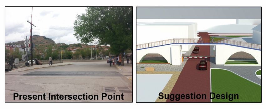
Sustainability 2021, 13, x FOR PEER REVIEW                                                                                        4 of 13
      Sustainability 2021, 13, 3055                                                                                                      4 of 13

                                       Figure 1. Location of the research area (Original, 2017).
                                  Figure 1. Location of the research area (Original, 2017).
                                              Also, oral interviews with the related institutions and photographs taken in the area
                                        Çankırı
                                         were used cityaslies between
                                                          auxiliary      40° 30′ and 41° north latitudes and 32° 30′ and 34° east
                                                                     materials.
                                  longitudesThe in the   northwestern
                                                     purpose            part of Central
                                                                of the greenway           Anatolia.
                                                                                    in greenway      Kastamonu
                                                                                                   planning      and is
                                                                                                             process  Zonguldak     lie to
                                                                                                                         the most important
                                  the north
                                         factorofinthe  city, Bolu to
                                                     determining    thethe  west, Ankara
                                                                         method.            to thecan
                                                                                    Greenways       south, and Çorum
                                                                                                      be designed       to the
                                                                                                                   to serve     east;
                                                                                                                              one      the or
                                                                                                                                   purpose
                                  surface   areathan
                                         more     is 2210   km2 and the
                                                       one purpose.        sea level
                                                                      Because        is 736
                                                                                of these    m [17].the
                                                                                         reasons,    The city center
                                                                                                       greenway      consists
                                                                                                                 planning      of 24 dis-
                                                                                                                             process  is varied.
                                  tricts.But generally it consists of three stages: inventory-analysis, preparing a conceptual or draft
                                        Today,
                                         plan, and
 Sustainability 2021, 13, x FOR PEER REVIEW       there
                                                      the is no passenger
                                                           preparation       transportation
                                                                        of the                 on the Çankırı railway. Due to heavy
                                                                                master plan [18].                                                5 of 13
                                  use of highway        in 2012,
                                              In the study,       passenger
                                                               creating       transportation
                                                                         the greenway           was closed.
                                                                                         was planned         Only freight
                                                                                                       and designed         transport
                                                                                                                      according          is
                                                                                                                                  to [3,18–23].
                                  carried  out.
                                         The  method was carried out in 4 interrelated stages (Figure 2).
                                        In order to obtain data in the research and to interpret and evaluate the data ob-
                                  tained, various scales, maps (the contour lines, soil, hydrology, development plan,
                                  transportation, etc.), and reports were used. Geographic Information Systems (ArcGIS
                                  10.3), design program (Autocad 2017), graphic design program (Photoshop CC 2017),
                                  and 3D modeling software (SketchUp 2017), etc. were used at various stages in the study.
                                        Also, oral interviews with the related institutions and photographs taken in the area
                                  were used as auxiliary materials.
                                        The purpose of the greenway in greenway planning process is the most important
                                  factor in determining the method. Greenways can be designed to serve one purpose or
                                  more than one purpose. Because of these reasons, the greenway planning process is var-
                                  ied. But generally it consists of three stages: inventory-analysis, preparing a conceptual
                                  or draft plan, and the preparation of the master plan [18].
                                        In the study, creating the greenway was planned and designed according to [3,18–
                                  23]. The method was carried out in 4 interrelated stages (Figure 2).

                                        Figure2.
                                       Figure    Methodology ofofthe
                                              2. Methodology      theresearch (Original,
                                                                       research          2017).
                                                                                (Original,  2017).

                                            In the first stage, the literature was searched for the purpose of this study and nec-
                                       essary data were collected. In addition, the boundaries of the research corridor were de-
                                       termined. Although the width and length of the corridor in greenway works vary ac-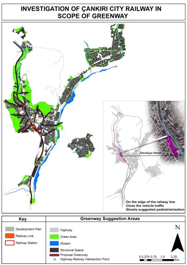
Sustainability 2021, 13, 3055                                                                                            5 of 13

                                     In the first stage, the literature was searched for the purpose of this study and necessary
                                data were collected. In addition, the boundaries of the research corridor were determined.
                                Although the width and length of the corridor in greenway works vary according to the
                                purpose, it is recommended that it be as wide as possible [18,24].
                                     Subsequently, the obtained and produced data with GIS were analyzed. As a result
                                of the analysis made at the third stage, a proposed conceptual plan was prepared. While
                                preparing this plan, first the suitability analysis of [25,26] was made on the maps created
                                to determine the areas suitable for greenway use. Then, to create an effective greenway
                                plan, “hub and spoke model” used by [21,27] was targeted. The hub areas (especially open
                                green areas and recreational areas) determined from the development plan’s map were
                                evaluated together in terms of providing connection with potentially suitable areas. If
                                those suitable areas cannot link the defined hubs, the hubs will be linked to the trails that
                                contain various uses (bicycle and pedestrian ways) inside them. Also, considering the
                                contribution of greenways to urban transportation, CSS was also taken into consideration
                                while preparing the plan.
                                     At the last stage, in the direction of the conceptual plan, the station area, an intersec-
                                tion, and an area for pedestrianization on the route were designed and have been made
                                suggestions about the field.

                                3. Results and Discussion
                                     A total of 1500 m wide corridor was determined, 750 m from both sides of the railway,
                                and this corridor mainly was analyzed. These analyses were evaluated under two headings
                                according to natural and cultural data using GIS.

                                3.1. Natural Landcape Characteristics
                                •    Height groups: The height range varies between 650 m to 850 m. These values are
                                     suitable for human comfort.
                                •    Slope groups: Slope in greenway studies is a very important criterion in planning
                                     activities. In the map, the slope groups were taken into account under seven categories
                                     with percentage (%) slope type. The groups were classified as suitable for greenway
                                     studies [28]. According to analysis results, most of the area has a slope of nearly
                                     0–3%. In addition, it was found in areas with 3–8% slight slope and 8–12% slope.
                                     While 5% slope is suitable for multi-purpose greenways, 3% max is preferable. 8%
                                     slope is suitable for bicycle use. Therefore the area for greenway use mostly has a
                                     suitable slope.
                                •    Aspect status: Aspect is defined as the direction of the slope surface. It is measured by
                                     0–360◦ clockwise starting from the north. Since the areas with a straight slope do not
                                     point in any direction, −1 value was assigned. According to Akar et al. (2006), the
                                     aspect factor plays a guiding role in the natural environmental characteristics such as
                                     humidity, precipitation, wind, and sunshine duration and intensity in the areas [3].
                                     Northern aspects are cooler and shady; southern aspects are hot and sunny [29].
                                     Most of the corridor has a flat area. Some areas and the parts where the train station
                                     is located have the east and northeast aspect. This situation will not constitute an
                                     obstacle for the corridor with an appropriate vegetative arrangement. If the evergreens
                                     are positioned on the north of the trail, they protect the trail from cold winter winds.
                                     The deciduous trees should be positioned on the south of the trail. These trees provide
                                     shadow during summer and they make the trail benefit from sun rays by defoliating
                                     during winter [28].
                                •    Large Soil Groups: There is brown soil and alluvial soil groups throughout the corridor.
                                     The amount of alluvial soil is about 300 hectares. Alluvial soils are deep, permeable,
                                     easily processed, fertile soils. There is no soil data in the built areas. The station area
                                     is also located in the area where there is no soil data.
                                •    Land use capability classes: There is no soil data in the built areas. The station area is
                                     also located in the area where there is no soil data. But, most of the corridor has Class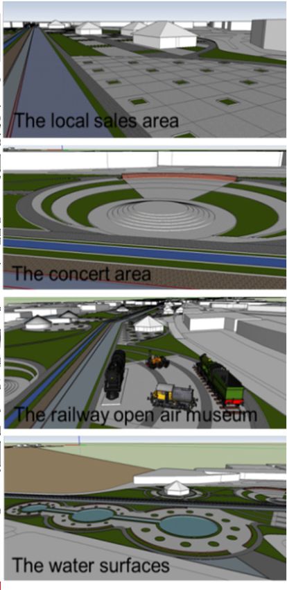
Sustainability 2021, 13, 3055                                                                                             6 of 13

                                     I agricultural land, as well as class IV, VI, and VIII areas. It should be ensured that 1st
                                     class lands are not used for non-agricultural purposes.
                                •    Risk of erosion: Most of the area has very slight erosion risk. Erosion risk situation
                                     was created by overlaying slope, vegetation density and soil data.
                                •    Visibility analysis: This analysis was carried out along the railway line. A large part
                                     of the environment can be seen from the area. The building heights were not taken
                                     into account in the analysis; the field of view may be interrupted due to floor heights
                                     and construction.
                                •    Hydrology: Stream lines in the study area were analyzed. Only Tatlıçay passes
                                     through the area. In a certain part of the study area, the stream flows parallel to the
                                     railway line.
                                •    Geological structure: Alluvial rock structure is visible in the study area. Built areas are
                                     located on this structure. These areas are important for agriculture and are not suitable
                                     for settlement in terms of flood and seismicity. Considering that Çankırı province is in
                                     the second degree earthquake zone, this constitutes a significant risk.

                                3.2. Cultural Landcape Characteristics
                                •    Structural areas: Structural areas were examined through the city development plan
                                     and in this context, conditions such as dwelling density, building use cases, and
                                     registered buildings were analyzed. Accordingly, it was determined that there is
                                     medium and low density in the northern part, dense in the center and near the
                                     station area, and less intense in the southern part of the railway passing through the
                                     zoning boundaries.
                                •    Urban green areas: Areas such as parks, reforestation sites, vineyards and gardens,
                                     forests, and central reserve areas have been identified green areas. Potential green-
                                     way routes that will ensure the connectivity between these areas were determined.
                                     According to the calculations made from the land use map, the amount of green areas
                                     per person in Çankırı city center is 5.7 square meters. According to the Spatial Plans
                                     Construction Regulations in Turkey, the amount of green areas required per person in
                                     urban areas should be at least 10 square meters [30]. The number of green areas per
                                     person in Çankırı city center is quite below the value it should be. At this point, the
                                     contributions of greenways to cities as linear open green areas are of great importance.
                                •    Transportation: Çankırı province is located on the D-765 highway connecting Ankara
                                     and Kırıkkale to Kastamonu. The road and the rail transport networks were mapped.
                                     According to this, there are 3 and 4 degree roads in and around the study area.
                                     Transportation in the city is provided by public transport and private vehicles. Bicycle
                                     use is intertwined with existing traffic; it is not separated. This situation poses an
                                     important problem in terms of life safety. The railway line passing through the city is
                                     the Ankara—Zonguldak railway line. This line was used for passenger and freight
                                     transport in the past, but today it is only used for freight transport.

                                3.3. Planning and Design
                                3.3.1. Greenway Conceptual Plan
                                     The natural and cultural data above overlap with each other and suggested greenway
                                routes were determined. In this phase, slope, large soil groups, hydrology, structural areas,
                                urban green areas, and transportation layers were used (Figure 3).
                                     As [19,27,31–33] stated in their studies, the proposed greenways, which are suggested
                                in this plan, will prevent building in areas with erosion risk, agricultural lands, and
                                alluvium areas. Greenways to be implemented contribute to the protection of biological
                                diversity and water resources. The environmental benefits of greenways vary according to
                                the scale of the project [34–36]. It is also stated that the wider greenways provide a greater
                                impact on the environment.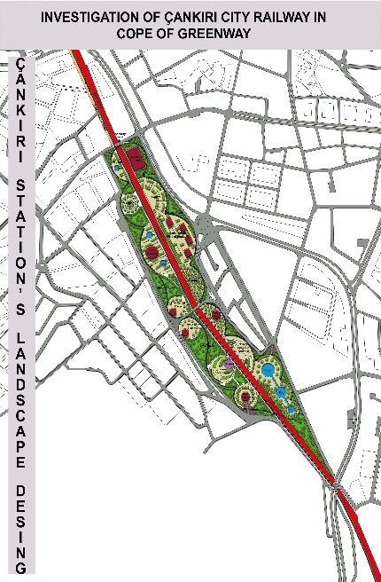
3.3. Planning and Design
                                  3.3.1. Greenway Conceptual Plan
                                       The natural and cultural data above overlap with each other and suggested green-
Sustainability 2021, 13, 3055                                                                                         7 of 13
                                  way routes were determined. In this phase, slope, large soil groups, hydrology, structural
                                  areas, urban green areas, and transportation layers were used (Figure 3).

                                  Figure3.3.Used
                                 Figure      Usedlayer
                                                  layerfor
                                                        forConceptual
                                                            ConceptualGreenway
                                                                       GreenwayPlan
                                                                                Plan(Original,
                                                                                     (Original,2017).
                                                                                                2017).

                                           A large part of the planned route of the proposed greenways passes through the
                                            As [19,27,31–33] stated in their studies, the proposed greenways, which are sug-
                                     densely built urban area. Therefore, it is considered that the environmental benefit may be
                                      gested in this plan, will prevent building in areas with erosion risk, agricultural lands,
                                     less than other benefits. However, the environmental benefits will increase over time, as
                                      and alluvium areas. Greenways to be implemented contribute to the protection of bio-
                                     the greenways themselves are not a source of pollution.
                                      logical diversity and water resources. The environmental benefits of greenways8 vary
Sustainability 2021, 13, x FOR PEER REVIEW                                                                                          of 13
                                           In the direction of the plan, a green zone of 2 m was left from the border of the railway
                                      according to the scale of the project [34–36]. It is also stated that the wider greenways
                                     line (parcel limit) for bicycle route arrangement on the side of the railway. From this
                                      provide a greater impact on the environment.
                                     distance, a bicycle route was proposed with 2.4 m. width as round-trip. In addition, it has
                                            A large part of the planned route of the proposed greenways passes through the
                                     has been
                                     been        proposed
                                            proposed        to build
                                                      to build       bicycle
                                                                bicycle       or pedestrian
                                                                        or pedestrian   pathspaths
                                                                                               basedbased    on existing
                                                                                                      on existing        road routes
                                                                                                                   road routes in orderin
                                      densely built urban area. Therefore, it is considered that the environmental benefit may
                                     order
                                     to      to connect
                                        connect          with open-=
                                                  with open-=         green(hubs)
                                                                green areas   areas (hubs)  in the
                                                                                     in the city   city (Figure
                                                                                                 (Figure 4).     4).
                                      be less than other benefits. However, the environmental benefits will increase over time,
                                      as the greenways themselves are not a source of pollution.
                                            In the direction of the plan, a green zone of 2 m was left from the border of the
                                      railway line (parcel limit) for bicycle route arrangement on the side of the railway. From
                                      this distance, a bicycle route was proposed with 2.4 m. width as round-trip. In addition, it

                                 Figure 4.
                                 Figure 4. Conceptual
                                           Conceptual Greenway
                                                      Greenway Plan
                                                               Plan for
                                                                     for Çankırı
                                                                         Çankırı City
                                                                                 City (Original,
                                                                                       (Original,2017).
                                                                                                 2017).

                                 3.3.2. Recommendation Pedestrian Area for Isfendiyar Street
                                    In the scope of the research, a pedestrianization for Isfendiyar Street with a width of
                                 7 m was proposed for pilot purposes. 2 m of the street was reserved for building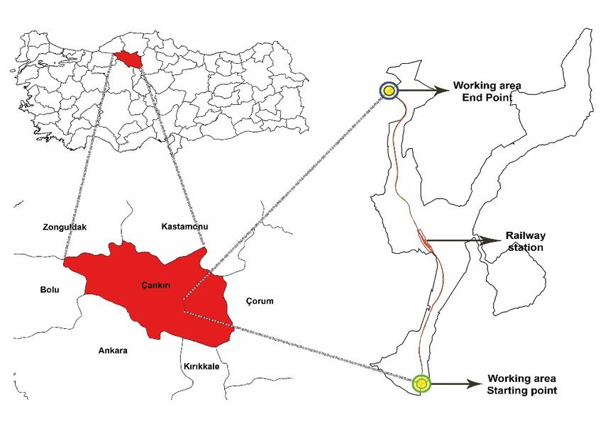
Sustainability 2021, 13, 3055 8 of 13
Figure 4. Conceptual Greenway Plan for Çankırı City (Original, 2017).
3.3.2. Recommendation Pedestrian Area for Isfendiyar Street
3.3.2. Recommendation Pedestrian Area for Isfendiyar Street
In the scope of the research, a pedestrianization for Isfendiyar Street with a width of
In the scope of the research, a pedestrianization for Isfendiyar Street with a width of
7 m was proposed for pilot purposes. 2 m of the street was reserved for building
7 m was proposed for pilot purposes. 2 m of the street was reserved for building front-
front-shares and part of the 5 m was proposed for arrangement. Figure 5 shows situation
shares and part of the 5 m was proposed for arrangement. Figure 5 shows situation after
after project implementation of İsfendiyar Street.
project implementation of İsfendiyar Street.
Figure 5. A view from İsfendiyar Street (before and after) (Original, 2017).
Figure 5. A view from İsfendiyar Street (before and after) (Original, 2017).
In this study, the basic features of linearity and connection formation, which are
In this
common study,
points the definitions
in the basic features of linearity
of greenways in and connection
the literature formation,
[6,36] and in thewhich are
planned
common points in the definitions of greenways in the literature [6,36]
study, were taken into consideration, and cycling and walking path opportunities were and in the planned
study,
Sustainability 2021, 13, x FOR PEER REVIEW
providedwere fortaken into consideration,
the citizens. These trails and cycling
created forand walkingalso
recreation pathserve
opportunities
the purpose9were
of 13of
provided for the citizens.
alternative transportation. These trails created for recreation also serve the purpose of al-
ternative transportation.
As Benedict and McMahon also Keith stated in their work concerning one of the
As Benedict and McMahon alsourban
Keithenvironment
stated in their workgreenways
concerning one of the
amount of green space areas
important open green and airin the
quality in the area. In [37,38],
a study by Novak increase (1994), thethe
important
amount ofopen
green green
spaceareas
and in
air the urban
quality environment
in the area. In[37,38],
a study greenways
by Novak increase
(1994), the
the
greenways and trails, especially with plants, avoided the $1 million spent on air pollution
greenways and trails, especially with plants, avoided the $1 million spent
prevention in Chicago, Illinois, thanks to the air filtering properties of the plants [39]. on air pollution
prevention
With in Chicago, around
the afforestation Illinois, the
thanks to the air
proposed filtering properties
greenway, it has been of thought
the plantsto[39].
bothWith
in-
the afforestation
crease the amountaround thespace
of green proposedin thegreenway,
city and itincrease
has beenthe thought to both
air quality of increase
the city by the
amount of green space in
providing an air flow corridor. the city and increase the air quality of the city by providing an air
flowIsfendiyar
corridor. Street section, where planning works were carried out, was planned as an
area toIsfendiyar
be used to Street section,
eliminate thewhere
lack ofplanning
walkingworks were carried
and gathering areasout, was planned
caused as an
by urbaniza-
area to be used to eliminate the lack of walking and gathering areas caused
tion. This planning contributes to the social sustainability dimension by strengthening by urbanization.
This planning
social contributesresidents
ties for neighboring to the socialand sustainability
citizens of the dimension
city [7,40]. by strengthening social
ties for neighboring residents and citizens of the city [7,40].
3.3.3. Recommendation for the Intersection Point
3.3.3. Recommendation for the Intersection Point
Level crossings at the intersection of the railroad and the highway are monitored by
Level crossings at the intersection of the railroad and the highway are monitored by
attendant
attendantand
andautomatic
automaticsignal
signalsystems
systems(Figures
(Figures66and
and7).
7).Our
Ourline
linehas
hasfive
fiveuncontrolled,
uncontrolled,
two bridges, and two controlled passes.
two bridges, and two controlled passes.
Figure 6. Proposal of intersection point (Original, 2017).
Figure 6. Proposal of intersection point (Original, 2017).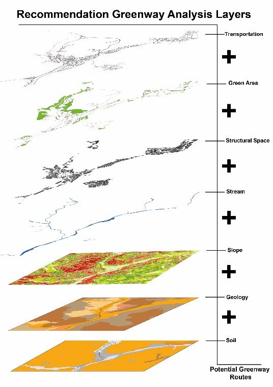
Sustainability 2021, 13, 3055 9 of 13
Figure 6. Proposal of intersection point (Original, 2017).
2017).
Figure 7. Proposal of intersection point (Original, 2017).
In
In the
the study,
study, the
the intersection
intersection points
points planned
planned byby considering
considering the
the CSS
CSS criteria
criteria [41]
[41]
provide the connection between new alternative transportation routes and urban
provide the connection between new alternative transportation routes and urban roads.roads.
3.3.4.
3.3.4. Station
Station Area
Area Landscape
Landscape Design
Design
The
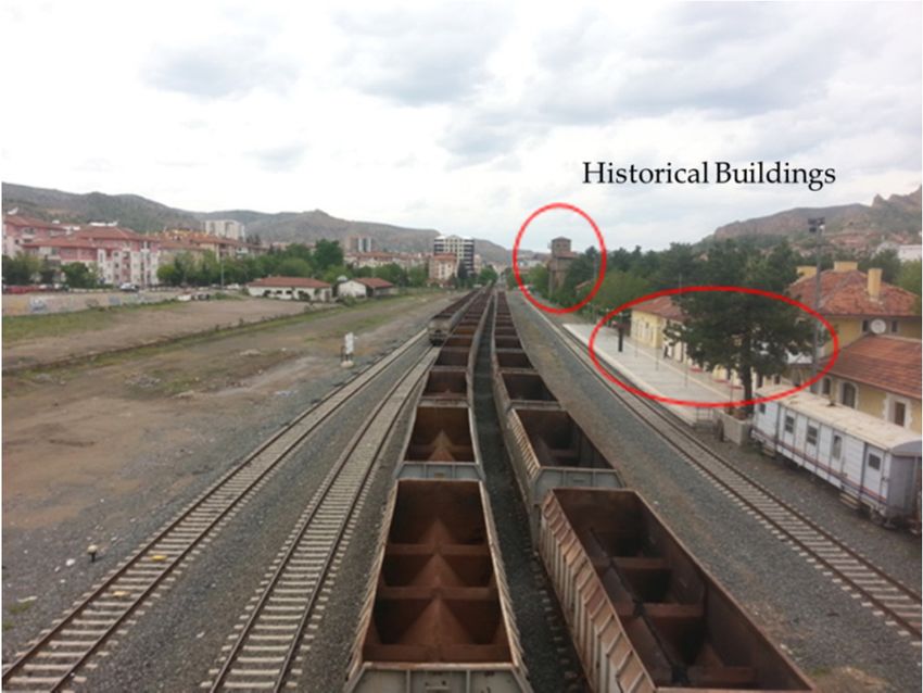
Sustainability 2021, 13, x FOR PEER REVIEW design area with seven historical buildings covers an area of approximately
10 of 13
The2 design area with seven historical buildings covers an area of approximately
16,000 m 2. These buildings have been preserved in the design (Figure 8).
16,000 m . These buildings have been preserved in the design. (Figure 8)
Figure8.8.Historical
Figure Historicalbuildings
buildingsin
instation
stationarea
area(Original,
(Original,2017).
2017).
Thedesign
The designwaswasmade
madeto tosupport
supportthethesuggestion
suggestionof ofthe
thebicycle
bicyclepath
pathatatthe
theside
sideof
ofthe
the
railway line.
railway line. For
For this
this reason,
reason, bicycle
bicycle route
route and
andbicycle
bicycle rental
rentaland
andsales
salesplaces
placeswere
werealso
also
includedin
included inthe
thearea.
area.Station
Stationareas
areaswere
weredesigned
designedas assquares
squaresand
andincluding
includingarrangements
arrangements
suchas
such aseating
eatingandanddrinking
drinkingareas,
areas,local
localsales
salesarea,
area,water
watersurfaces
surfacesfor
forscenery
scenerypurposes,
purposes,
sittingrest
sitting restareas,
areas,concert
concertareas,
areas,and
andaarailway
railwayopen
openairairmuseum
museum(Figure
(Figure9).
9).
Station area designed by taking into account the multifunctional basic feature of
greenways provides the opportunity for recreation to city people while ensuring the
protection of historical and cultural areas. Multifunctionality is a feature that often limits
planners [6,19]. The plan and design made includes various functions such as alternative
transportation, historical protection, and recreation.
The station area connects the recreation areas, walking and bicycle paths within the
planned greenway with the urban transportation system. Also, as noted in the work
of [21,36,42], greenways have a value that can increase the property value in neighbor-
ing lands.The design was made to support the suggestion of the bicycle path at the side of th
railway line. For this reason, bicycle route and bicycle rental and sales places were als
included in the area. Station areas were designed as squares and including arrangement
Sustainability 2021, 13, 3055 10 of 13
such as eating and drinking areas, local sales area, water surfaces for scenery purpose
sitting rest areas, concert areas, and a railway open air museum (Figure 9).
Figure9. 9.
Figure Landscape
Landscape design
design for Station
for the the Station
Area Area (Original,
(Original, 2017). 2017).
The main goal
Station area ofdesigned
the ‘Habitat-2 City Summit’
by taking held in the
into account 1996,multifunctional
when sustainability wasfeature o
basic
brought to the dimension of the city and its living environment, is to have
greenways provides the opportunity for recreation to city people while ensuring th healthy, safe,
equal and sustainable cities, towns and villages now and in the future [43,44]. Development
protection of historical and cultural areas. Multifunctionality is a feature that often limi
plan of Turkey [45] supports the expansion of pedestrian-bicycle transportation and increase
ofplanners [6,19].
open green The
spaces forplan and of
the scope design made includes
sustainability various
and livable functions
environment. such
In this as alternativ
respect,
transportation, historical protection, and recreation.
the development plan coincides with the conceptual plan proposed in the study. There is
The station
no greenway area
practice connects
in the country,the recreation
especially areas,railways.
for active walkingThe andconceptual
bicycle paths within th
plan is
aplanned
study thatgreenway withby
can be applied the urban transportation
presenting system. Also, as noted in the work o
it to the local administration.
Greenways
[21,36,42], can follow
greenways man-made
have a valuecorridors
that can as well as natural
increase corridors.
the property valueThis
inplan
neighborin
consists
lands. of 11,691 m of railway and greenways following the existing transportation axes. In
future studies, a regional greenway system can be established by planning a comprehensive
greenway system with the natural corridors to be added to the project and the continuation
of the railway line.
4. Conclusions
Greenways are an effective tool in solving the problems arising from urbanization
with the environmental, economic, and social benefits they provide, as well as a sustainable
approach because it observes the protection-use balance in planning. For this reason,
greenway planning has gained importance day by day and has become widespread in
many countries.
In this study, a conceptual greenway plan was created by analyzing approximately
11 km of the railway line in active use and greenways following the existing transportation
axes in Çankırı in line with the greenway planning principles. This conceptual plan was
formed with an integrated approach that took the advantage of the opportunities and
evaluated the present unities. The goals of the plan are listed below:
• Connections between the hubs that are present,
• Alternative transportation,
• Spaces for people,
• Recreational opportunities for the public.
According to this plan, proposal designs were created at the intersection points of the
station area and highway and railway axes. In addition, the pedestrianization of IsfendiyarSustainability 2021, 13, 3055 11 of 13
Street and the arrangement of a bicycle path along the railway line were proposed. On the
Tatlı Su Adası Street, only pedestrianization and bicycle path crossings were suggested.
Pedestrian and bicycle paths will be created on the existing road routes that slope
allows in order to provide connection with the open green areas of the city.
Planning and design studies have been prepared to include minimum interruption for
users. The project complies with the CSS criteria as it creates areas for safe use that preserve
the landscape and the aesthetic, historical, and natural resource values of the region.
Planting trees and shrubs suitable for Çankırı conditions in the proposed trails will
also be visually and functionally supportive.
With this plan will be offered the creation of both walking and cycling opportunities for
the people of the city and physical activity; at the same time, air quality will be supported
by increasing the amount of green space. As a result, the project prepared will contribute
to effective transportation, a healthy society, and a healthy environment in the city.
The implementation of this plan and design should proceed in cooperation with
different professional disciplines, and ongoing public participation should be ensured.
In the USA, where successful practices in greenway planning are exhibited, it is
extremely important to ensure public participation in organizations. Public participation
through organizations will increase the success from determining the goals and objectives
of the greenway project to the implementation of the plan. For this purpose, an advisory
committee should be formed to represent the public.
Author Contributions: All authors conceived and designed the article. Conceptualization, U.P.T.
and P.E.E.; data collecting, F.Ö., P.E.E. and Ö.B.T.; land surveying and photographing, Ö.B.T. and F.Ö.;
translating for the theoretical structure, P.E.E.; methodology, U.P.T., F.Ö., P.E.E. and Ö.B.T.; analysis,
U.P.T. and F.Ö.; software, F.Ö.; visualition, F.Ö. and Ö.B.T.; writing, Ö.B.T.; revision, U.P.T. All authors
have read and agreed to the published version of the manuscript.
Funding: This research received no external funding.
Institutional Review Board Statement: The study was conducted according to the guidelines of the
Declaration of Helsinki. This study does not require live animal experiments or poll with humans.
Informed Consent Statement: Informed consent was obtained from all subjects.
Data Availability Statement: Not applicable.
Conflicts of Interest: The authors declare no conflict of interest.
References
1. Vasconcelos, S. Greenways, A Path towards Urban Sustainability. Master’s Thesis, Faculdade de Ciências e Tecnologia da
Universidade Nova de Lisboa, Caparica, Portugal, 2006.
2. Euronews. Available online: https://tr.euronews.com/2019/10/17/nufus-yogunlugu-artan-kentlerde-surdurulebilir-kalkinma-
nasil-saglanabilir (accessed on 11 October 2019).
3. Pekin, U. Kentsel Akarsu Koridorlarının Geliştirilmesi ve Ankara Çayı Kavramsal Yeşil yol Planı. Ph.D. Thesis, Ankara
Üniversitesi, Ankara, Türkiye, 2007.
4. Little, C.E. Greenways for America; The Johns Hopkins Press Ltd.: Baltimore, MD, USA, 1995; pp. 1–237.
5. Turner, T. Greenway planning in Britain: Recent work and future plans. Landsc. Urban Plan. 2006, 76, 240–251. [CrossRef]
6. Ahern, J. Greenways as a planning strategy. Landsc. Urban Plan. 1995, 33, 131–155. [CrossRef]
7. Lindsey, G. Sustainability and Urban Greenways:Indicators in Indianapolis. J. Am. Plan. Assoc. 2003, 69, 165–180. [CrossRef]
8. Vasconcelos, P.; Pritchard, M. A Greenway Network for a more Sustainable Auckland. In Proceedings of the 2nd international
Conference on Sustainability Engineering and Science, Auckland, New Zealand, 20–23 February 2007.
9. Jongman, R.H.G.; Pungetti, G. Introduction: Ecological Networks and Greenways; Amsterdam University Press: Amsterdam, The
Netherlands, 2004; pp. 1–6.
10. Jones, T.A. Rails to Trails: Converting America’s Abandoned Railroads into Nature Trails. Akron Law Rev. 1989, 22, 645–660.
11. Pack, K.; Thomas, P. America’s Rails-with-Trails; Rails-to-Trails Conservancy: Washington, DC, USA, 2013; pp. 1–33.
12. Reis, A.C.; Jellum, C. New Zealand Rail Trails: Heritage Tourism Attractions and Rural Communities. In Railway Heritage and
Tourism: Global Perspectives; Conlin, M.V., Bird, G.R., Eds.; Channel View Publications: Bristol, UK, 2014; pp. 90–104.Sustainability 2021, 13, 3055 12 of 13
13. Bezgin, N.Ö. Hizmet Dışı Kalmış Bir Ulaştırma Yapısının Çağdaş Kentsel Arayışlar İçerisinde Yaratıcı Şekilde Geri Kazanılması:
“The High Line Project-Manhattan, New York City”. Dünya Şehircilik Günü 38. Kolokyumu, İstanbul, Türkiye, 2014. Available
online: https://www.academia.edu/9846430/Hizmet_D%C4%B1%C5%9F%C4%B1_Kalm%C4%B1%C5%9F_Bir_Ula%C5%9
Ft%C4%B1rma_Yap%C4%B1s%C4%B1n%C4%B1n_%C3%87a%C4%9Fda%C5%9F_Kentsel_Aray%C4%B1%C5%9Flar_%C4
%B0%C3%A7erisinde_Yarat%C4%B1c%C4%B1_%C5%9Eekilde_Geri_Kazan%C4%B1lmas%C4%B1_The_High_Line_Project_
Manhattan_New_York_City_ (accessed on 27 May 2020).
14. Pennsylvania Great Outdoors Visitors Bureau. Available online: https://visitpago.com/listings/clarion-little-toby-creek-trail/
(accessed on 18 May 2017).
15. Dondi, G.; Simonea, A.; Lantieria, C.; Vignalia, V. Bike lane design: The context sensitive approach. Procedia Eng. 2011, 21,
897–906. [CrossRef]
16. Beukes, E.; Vanderschuren, M. A gıs-based context sensitive solution for multimodal road planning. In Proceedings of the South
African Transport Conference, Pretoria, South Africa, 11–14 July 2011.
17. Anonymous. Çankırı İl Çevre Durum Raporu; T.C. Çankırı Valiliği İl Çevre ve Orman Müdürlüğü: Çankırı, Türkiye, 2011; pp. 3–5.
18. Flink, C.; Searns, R.H. Greenways: A Guide to Planning, Design and Development; Island Press: Washington, DC, USA, 1993;
pp. 1–365.
19. Conine, A.; Xiang, W.-N.; Young, J.; Whitley, D. Planning for multi-purpose greenways in Concord, North Carolina. Landsc. Urban
Plan. 2004, 68, 271–287. [CrossRef]
20. Arslan, M.; Barış, E.; Erdoğan, E.; Dilaver, Z. Yeşil yol Planlaması Ankara Örneği. Ph.D. Thesis, Ankara Üniversitesi, Ankara,
Türkiye, 2007.
21. Trails and Greenways Master Plan City of Greenville South Carolina. Available online: https://www.greenvillesc.gov/
DocumentCenter/View/293/Trails-and-Greenways-Master-Plan?bidId= (accessed on 4 October 2017).
22. Miller, W.C.; Collins, M.G.; Steiner, F.R.; Cook, E.R. An approach for greenway suitability analysis. Landsc. Urban Plan. 1998, 42,
91–105. [CrossRef]
23. Toccolini, A.; Fumagalli, N.; Senes, G. Greenways planning in Italy: The Lambro River Valley Greenways System. Landsc. Urban
Plan. 2006, 76, 98–111. [CrossRef]
24. Fabos, J.G. Introduction and overview: The greenway movement, uses and potentials of greenways. Landsc. Urban Plan. 1995, 33,
1–13. [CrossRef]
25. McHarg, I. Design with Nature; The Natural History Press: New York, NY, USA, 1969; pp. 1–197.
26. Yılmaz, E. Bir Arazi Kullanım Planlaması Modeli: Cehennemdere Vadisi Örneği; Çevre ve Orman Bakanlığı Doğu Akdeniz Ormancılık
Araştırma Enstitüsü: Tarsus, Türkiye, 2005; pp. 1–133.
27. Two River Area Greenways Plan. Available online: https://bushkillorg.files.wordpress.com/2019/11/two_rivers_area_
greenway_plan. (accessed on 20 April 2017).
28. Flink, C.A.; Ryan, K.; Searns, R.M.; Balmori, D.; Lagerwey, P. Trails for the Twenty-First Century: Planning, Design, and Management
Manual for Multi-Use Trails; Island Press: Washington, DC, USA, 1993; pp. 1–213.
29. Erol, O. Genel Klimatoloji; Gazi Büro Kitabevi: Ankara, Türkiye, 1993; pp. 1–55.
30. Resmi Gazete. Available online: https://www.resmigazete.gov.tr/eskiler/2014/06/20140614-2.htm (accessed on 4 October 2017).
31. Yu, K.; Li, D.; Li, N. The evolution of Greenways in China. Landsc. Urban Plan. 2006, 76, 223–239. [CrossRef]
32. Salıcı, A. Çatalan Baraj Gölü-Deli Burun Aksında Seyhan Nehri’nin Yeşil Koridor Potansiyelinin Araştırılması. Ph.D. Thesis,
Çukurova Üniversitesi, Adana, Türkiye, 2009.
33. Taylor, J.; Paine, C.; FitzGibbon, J. From greenbelt to greenways: Four Canadian case studies. Landsc. Urban Plan. 1995, 33, 47–64.
[CrossRef]
34. Kappler, C.; Miller, L. Re-İmagining the Urban Greenway: An Alternative Transportation Strategy and Vacant Land Use Plan for
the Woodbridge Neighborhood of Detroit. Master’s Thesis, The University of Michigan, Ann Arbor, MI, USA, 2009.
35. Baris, M.E.; Erdogan, E.; Dilaver, Z.; Arslan, M. Greenways and the Urban form: City of Ankara, Turkey. Biotechnol. Biotechnol.
Equip. 2010, 24, 1657–1664. [CrossRef]
36. Hellmund, P.C.; Smith, D.S. Designing Greenways: Sustainable Landscapes for Nature and People; Island Press: Washington, DC, USA,
2006; pp. 1–270.
37. Benedict, M.A.; McMahon, E.T. Green İnfrastructure: Linking Landscapes and Communities; Island Press: Washington, DC, USA,
2006; pp. 1–289.
38. Keith, S.J. Urban Greenway Use and Benefits in Diverse Cities: A Tale of Two Trails. Master’s Thesis, Clemson Univeristy,
Clemson, CA, USA, 2016.
39. Enhancing the Environment with Trails and Greenways. Available online: https://www.railstotrails.org/resourcehandler.ashx?
id=3062. (accessed on 5 September 2016).
40. Shafer, C.; Lee, B.K.; Turner, S. A tale of three greenway trails: User perceptions related to quality of life. Landsc. Urban Plan. 2000,
49, 163–178. [CrossRef]
41. Daisa, J.M. Context Sensitive Solutions in Designing Major Urban Thoroughfares for Walkable Communities; Institute of Transportation
Engineers: Washington, DC, USA, 2006; pp. 1–221.
42. Nicholls, S.; Crompton, J.L. The Impact of Greenways on Property Values: Evidence from Austin, Texas. J. Leis. Res. 2005, 37,
321–341. [CrossRef]Sustainability 2021, 13, 3055 13 of 13
43. Özcan, A. Ekolojik Temele Dayalı Sürdürülebilir Kentsel Gelişme: Malatya Kent Örneği Üzerinden Bir Değerlendirme. In
Proceedings of the ICANAS Uluslararası Asya ve Kuzey Afrika Çalışmaları Kongresi, Ankara, Türkiye, 10–15 September 2007.
44. Karakurt Tosun, E. Sürdürülebilirlik Olgusu ve Kentsel Yapıya Etkileri. Available online: https://personel.omu.edu.tr/docs/
ders_dokumanlari/1281_49893_1655.pdf (accessed on 5 February 2021).
45. Türkiye Cumhuriyeti Cumhurbaşkanlığı Strateji ve Bütçe Başkanlığı. Available online: https://www.sbb.gov.tr/wp-content/
uploads/2019/07/OnbirinciKalkinmaPlani.pdf (accessed on 5 October 2020).You can also read