Appendix G Priority Coastal Inundation Locations - September 2021 DRAFT - City of ...
←
→
Page content transcription
If your browser does not render page correctly, please read the page content below
Appendix G
    Priority
    Coastal
 Inundation
  Locations
     September 2021 DRAFT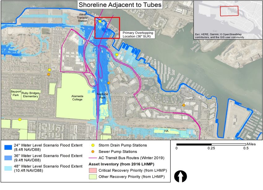
The Priority Coastal Inundation Locations appendix is adopted from Alameda’s 2019 Climate Action and
Resiliency Plan.

Priority Coastal Inundation Locations
The vulnerability assessment defined priority coastal inundation locations as those assets or areas
exposed to flooding risk soonest and with greatest consequence. Locations with significant flooding at a
total water level of 24 or 36 inches (above today’s high tide) were identified as at risk of sea level rise
flooding “soon.” Following climate change projections from the State of California, which the OPC
published in 2017 (Griggs et al., 2017), 36 inches of sea level rise can be expected between 2060 and
2070 when considering a high emissions scenario with medium to high risk aversion. A total water level of
36 inches is also equivalent to 50-year storm surge today. Alameda is implementing climate-smart
planning, as outlined in AB 2800, the “Climate-Safe Path for All.” Therefore, as Alameda demonstrates
leadership in GHG emissions reduction, the City should monitor global GHG emissions reduction
trajectories and incorporate them into the planning process.

The following criteria 1 were used to identify location-based priority flooding assets:

    Exposure assessment: Define the extent to which an asset experiences an impact. This includes
       considering the percent of an asset impacted as well as the probability of occurrence. The CARP
       vulnerability assessment was primarily concerned with exposure to flooding due to sea level rise
       and precipitation. Exposure in this assessment included both magnitude and timing (i.e., how
       much an asset is exposed to an impact and when exposure begins).

    Sensitivity assessment: Determine the degree to which assets are affected by climate change
       impacts, including non-physical influences like governance. Sensitivity refers specifically to the
       asset itself, whereas consequence considers impacts to surrounding communities and assets.

    Consequence assessment: Determine how impacts to the asset affect the surrounding community
       and assets, as well as Alameda more generally. Consider impacts to vulnerable communities as
       defined by a range of social vulnerability indicators.

    Adaptive capacity assessment: Define the ability of assets, systems, or people to adjust to an
       adverse impact. Consider how changes in operations and/or minor physical improvements could
       increase the resilience of an asset to climate change.

    Gap analysis: Consider assets and neighborhoods already addressed in existing City plans and
       commitments. Identify gaps to determine which assets are most critical to address. Determine the
       extent to which existing plans and commitments incorporate climate change.

The City has already evaluated sea level rise for select assets and projects. The CARP’s vulnerability
assessment did not re-examine existing commitments to adaptation, but rather builds on and aligns with
those actions underway. Table G-1 summarizes the key vulnerable assets addressed in existing City
plans and/or commitments.

1These components are adapted from the ART process, which considers exposure, sensitivity, and adaptive capacity
as components of vulnerability. The ART process also defines risk as the combination of likelihood and consequence,
with consequence contributing more to overall risk.

                                                                    Priority Coastal Inundation Locations | G-2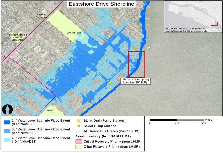
Table G-1. Key Vulnerable Assets in Existing City Plans and Commitments

                        Asset                                                  Plan
                                                       Alameda Point Master Infrastructure Plan (MIP) and
  Alameda Point Shoreline (including Main Street
                                                       Alameda Point Town Center and Waterfront Precise
  Ferry Terminal)
                                                       Plan
  City Hall West                                       Alameda Point MIP
  Northern Waterfront                                  Northern Waterfront Development Plans
  Shoreline Drive                                      City's 2017–2019 Capital Budget
                                                       Storm Drain Master Plan 2008 (focus on capacity
  Veteran's Court Seawall
                                                       upgrades)
  Storm Drain Pump Stations                            Storm Drain Master Plan 2008
  Sewer Pump Stations                                  Sewer System Management Plan 2017
                                                       Caltrans State Route 260 Transportation Concept
  State Route (SR) 260
                                                       Report (signed 2011, reaffirmed 2017)

The 11 priority flooding locations identified through this approach fall within three categories: shoreline,
natural, and recreation areas; utilities; and transportation. A detailed map for each location showing 36,
48, and 52 inches of sea level rise, as well as a one-page description of exposure, sensitivity,
consequence, and adaptive capacity, are included in Appendix H. These priority flooding locations are
described further below.

In addition, this section summarizes the vulnerability assessment results for the climate change
vulnerabilities broadly applied by sector in Alameda. Appendices G and H contain detailed vulnerability
profiles that align with the planning framework developed by the ART Program. The profiles include
vulnerability statements that consider the physical, functional, governance, and informational components
of an asset that contribute to sensitivities to climate impacts. Key issues and vulnerabilities for each
shoreline segment as well as adaptive capacity and potential consequences are identified.

Shoreline, Natural, and Recreation Areas
The vulnerability assessment identified critical points of overtopping along the shoreline of Alameda that,
if addressed, could substantially reduce flooding and inundation threatening residents, businesses, parks,
and key assets in Alameda. These segments are discrete locations along the shoreline that overtop at
lower sea level rise scenarios (24 or 36 inches) and therefore should be addressed first to help protect
other assets and increase the resilience of the shoreline to greater amounts of sea level rise.

Several other segments of the Alameda Point shoreline that are likely to be overtopped at 24 or 36 inches
of sea level rise were not defined as high priority because they are already addressed through the
approved Alameda Point MIP. The MIP established a framework for sea level rise protection and
adaptation at Alameda Point based on the best available science. It also set forth a monitoring and
financing program to periodically review the latest science, sea level rise estimates, and guidance from
local, state, and federal regulatory agencies. Amendments to the MIP will be adopted as needed to reflect
any notable conclusions from the ongoing monitoring. In fact, an MIP amendment will be adopted to
consistently reflect the conclusions of the CARP along with the latest OPC sea level rise projections and
guidance from 2018.

                                                                  Priority Coastal Inundation Locations | G-3
Transportation
Alameda relies heavily on functional bridges and tunnels to connect to the mainland, and a large
population relies on transit systems to commute. The vulnerability assessment focused on those assets
that transit-dependent populations most heavily use, such as roadways used by multiple AC Transit bus
routes, as well as transportation assets that are essential corridors on and off the island. To help organize
and simplify the results of the assessment, several transportation assets were bundled in the summaries
presented below.

Note: Transportation assets are also sensitive to the effects of other climate hazards, particularly extreme
heat, which can damage road surfaces and pose a hazard to workers. The summaries included here do
not discuss heat specifically because Alameda is not expected to experience temperatures that can
heavily impact transportation assets. While ferry access is essential on Alameda, the Main Street Ferry
Terminal was not identified as a high vulnerability because the City already has plans to adapt the area to
address flood risk at ferry access points.

Storm Utilities
Ensuring the long-term viability of utility systems in Alameda is important to maintaining a healthy and
vibrant city. In particular, the stormwater system is critical for ensuring proper drainage to prevent roads
and neighborhoods from flooding during storm events. The City has identified deficiencies in the
stormwater system that need to be funded and addressed to prepare Alameda for the impacts of sea
level rise and increased storm intensity and/or frequency. The vulnerability assessment identified
additional threats facing the stormwater system that would not be resolved by capacity upgrades to the
system.

Threats to the stormwater system include rising ocean levels, rising groundwater levels, and increased
storm intensity and/or frequency. Gravity-fed components of the stormwater system are particularly
vulnerable to rising ocean levels because outfalls can be blocked. Future pumps may be required in
locations currently served by gravity-fed outfalls. Rising groundwater levels associated with sea level rise
add more stress to the system overall and could potentially damage or reduce the functionality of
subsurface infrastructure. Additional assessment of the risk posed by rising groundwater levels is needed
as new information on groundwater, including modeling results, becomes available.

Table G-2 shows the 11 location-based priority flooding assets identified during the vulnerability
assessment, two of which include various locations. Figure G-1 shows their locations spatially on
Alameda Island, while Figure G-2 shows the flooding areas on Bay Farm Island.

                                                                  Priority Coastal Inundation Locations | G-4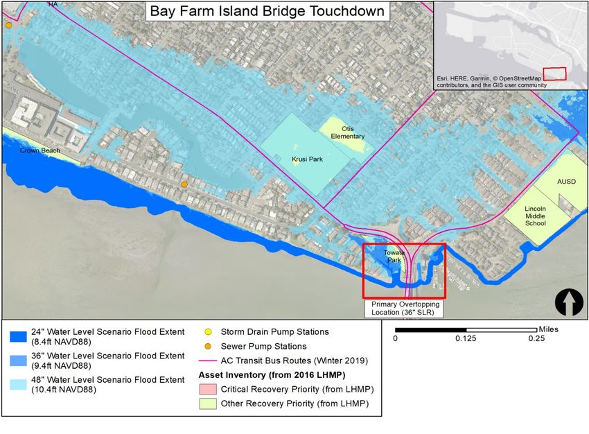
Table G-2. Location-Based Priority Flooding Assets

                                                                  ID for
     Asset                                                                           Exposure                 Exposure                                                Adaptive
                                Asset Name                     Figures 4-8                                                      Sensitivityc Consequenced
    Category                                                                      (Sea Level Rise)a        (25-Year Flood)b                                           Capacitye
                                                                 and 4-9
                  Shoreline Adjacent to Webster and
                                                                     1              Moderate (36")               None                Low              High             Moderate
                  Posey Tubes
                  Veteran's Court Seawall                           10              Moderate (36")               None               High           Moderate            Moderate

Shoreline,        Crown Beach and Bird Sanctuary                     3                 High (12")                None               High           Moderate            Moderate
Natural, and
Recreation        Bay Farm Island Bridge Touch Down
Areas                                                                4                Low (>48")                 None             Moderate         Moderate            Moderate
                  Area (Alameda Island side)

                  Eastshore Drive                                    5              Moderate (36")               None             Moderate            High               High

                  Bay Farm Island Lagoon System 1
                                                                     9              Moderate (36")               None             Moderate         Moderate            Moderate
                  Outlet Gate and Seawall

                  Storm Drain Pipes and Pump Stations            Citywide           Moderate (36")               Varies             High           Moderate            Moderate
Utilities
                  Bayview Weir and Outfall                           7                 High (24")                None               High              High               High

                  SR260 and Posey/Webster Tubes                      2              Moderate (36")         High (1 ft+ flood)       High              High                Low

               Critical and High-Use Roadways (used
Transportation by AC Transit)                                        6                Low (>48")           High (1 ft+ flood)     Moderate            High             Moderate

                  SR61/Doolittle Drive                               8              Moderate (36")         High (1 ft+ flood)        Low              High             Moderate

a Exposure (sea level rise): Low= > MHHW+48”; Moderate=MHHW+36”; High=MHHW+12–24”
b Exposure (25-year precipitation event): Low=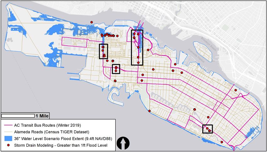
Figure G-1. Map showing the areas of location-based priority flooding on Alameda Island

                                                                       Priority Coastal Inundation Locations | G-6
Figure G-2 Map showing the areas of location-based priority flooding on Bay Farm Island

                                                     Priority Coastal Inundation Locations | G-7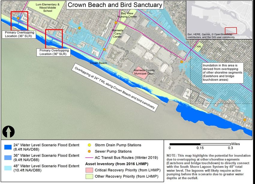
Table G-3. Crown Memorial State Beach Vulnerability Summary
Crown Memorial State Beach is a popular spot for recreation and education in Alameda. It has a pickleweed salt marsh that provides bird habitat in the
Elsie Roemer Bird Sanctuary at the east end of the beach, as well as an eelgrass bed just offshore of the beach that provides juvenile fish habitat. Crown
Beach and the bird sanctuary make up the majority of the natural shoreline on Alameda Island and are at substantial risk of erosion due to wave action and
inundation from sea level rise.
The narrow beach is vulnerable to sea level rise and storm surge flooding, as well as erosion due to wave action. It is backed by a road, housing,
Key
and shopping centers, giving it little capacity to migrate inland. Decisions on adaptation will involve the City (owns the land), East Bay Regional
Issue(s)
Parks District (EBRPD; manages the beach), and the community at large.
Lower elevation portions of the sandy beach are currently susceptible to flooding at king tides. Large portions of the beach and bird sanctuary are
Exposure inundated at 36” total water level, at which point small segments of Shoreline Drive also experience flooding originating at this location. At 48” total
water level, nearly all of the beach and bird sanctuary are overtopped, leading to flooding of adjacent neighborhoods.
Governance
The northern portion of the park is owned by California State Parks; the narrow southern part, including the beach and trail along Shoreline Drive, is
owned by the City of Alameda. EBRPD has operating agreements and manages the entire area (bird sanctuary and beach) as one park.
Informational
There is limited information on the efficacy of existing groins to prevent beach erosion.
EBRPD is working on a Crown Beach Master Plan update that will consider sea level rise; however, this work is currently on hold and it is unknown
when it will proceed.
Sensitivity Functional
The beach and bird sanctuary provide flood protection to important roads (e.g., Shoreline Drive), residential neighborhoods, and commercial areas
(e.g., South Shore Shopping Center).
Physical
The beach is not a natural structure and regular nourishment is needed. In 2013, sand was pumped in due to heavy erosion, and groins are used to
keep sand in place.
Several sensitive resources are present in this area, such as an eelgrass bed and salt marsh that provide nursery habitat and a food source for
aquatic birds, including some threatened and endangered species.
The beach is very narrow and backed by a road, so there is limited capacity to migrate inland as the beach erodes and lower-elevation portions
Adaptive
become permanently inundated. The sloping character of the beach and tidal flats offshore provide opportunities to adapt the shoreline through
Capacity
living or nature-based features.
Social: The beach is very popular for recreation and educational programs, and it is one of only a small number of sandy beaches in the East Bay.
Conse-
Economic: Crown Beach is an important tourist destination. Although no fees are collected, tourism brings money to businesses in the area.
quences
Environment: Habitat in this area could be lost if the Elsie Roemer Bird Sanctuary is inundated and no adaptation action is taken.
Priority Coastal Inundation Locations | G-8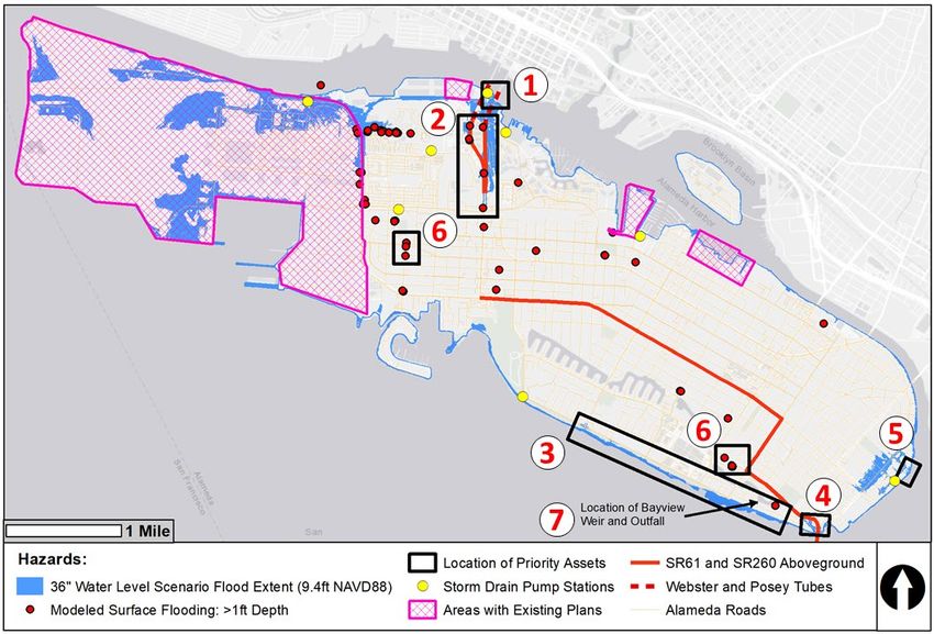
Priority Coastal Inundation Locations | G-9
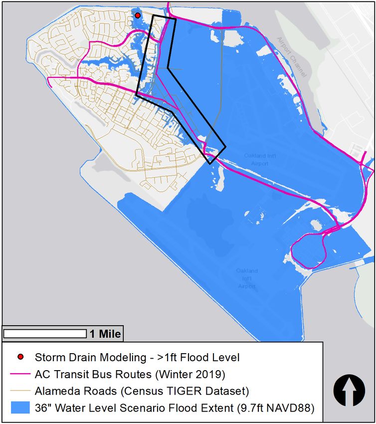
Table G-4. Eastshore Drive (Adjacent Shoreline) Vulnerability Summary
Eastshore Drive is the easternmost, north-south-oriented road on Alameda Island, providing access to the Eastshore and Fernside neighborhoods.
These residential neighborhoods have many homes with private docks in San Leandro Bay. Although there are several designated points of public
access along Eastshore Drive, there are no extensive public trails or parks along the shoreline. Private homes dominate the eastern waterfront. The
Federal Emergency Management Agency (FEMA) recently determined that sections of the Eastshore neighborhood are within the 1 percent annual
chance floodplain.
The Eastshore area is a low-lying section of the city with a large residential area vulnerable to flooding from sea level rise and storm events.
Key There is limited space for adaptation because homes are built out very close to the waterfront. A potentially complex collaboration with
Issue(s) homeowners and related groups (e.g., homeowners’ associations [HOAs]) will be necessary to agree upon shoreline protection measures due
to ownership in this area.
Overtopping of existing shoreline structures in this area begins at 36” total water level, at which point floodwaters extend inland, inundating
portions of Fernside Boulevard, the stormwater pump station serving this area, and areas as far inland as the fields near the Harrison
Exposure
Recreation Center. Initial shoreline overtopping is likely restricted to small sections of the shoreline (e.g., at the end of Liberty Drive), but more
substantial shoreline overtopping occurs along the east shore at higher water levels, beginning as early as 48” total water level.
Governance
Substantial portions of the east shoreline are privately owned. Beginning in 2005, ownership transfers between the U.S. Army Corps of
Engineers (USACE) and the City of Alameda, and then between the City and private landowners, resulted in individual property rights over
submerged lands along the shore. Property owners will likely need to buy in to potential shoreline protection solutions, although the actual
concrete seawall along properties in this area is part of City-owned parcels that are leased to homeowners.
Informational
There is no known inventory of the condition of shoreline protection structures in this area beyond basic shoreline elevation data.
Sensitivity Functional
Shoreline in this area protects residential communities and streets.
Physical
Nearly all of the east shoreline of Alameda Island is heavily armored with engineered flood protection structures like seawalls and levees. The
condition and quality of these structures determines their vulnerability to sea level rise and storm surge.
Environmental resources like submerged aquatic vegetation (SAV) are present throughout San Leandro Bay, including near the east shoreline
of Alameda Island. These resources provide important habitat for aquatic species and some level of wave attenuation.
There is very limited available space for constructing new shoreline structures, especially nature-based shorelines like living levees, which
Adaptive
generally require a much larger footprint. Tidal flats along this stretch of shoreline may provide opportunities for some nature-based adaptation
Capacity
strategies. FEMA floodplain designation in this area may open funding opportunities to address shoreline issues.
Social: Overtopping of this shoreline may lead to flooding of the Eastshore and Fernside neighborhoods, where few homes are flood-proofed.
Conse-
quences Environmental: Flooding of large residential areas could lead to the release of debris and invasive species into San Leandro Bay, where
restoration of sensitive habitats is currently underway.
Priority Coastal Inundation Locations | G-10Priority Coastal Inundation Locations | G-11
Table G-5. Shoreline Adjacent to Webster and Posey Tubes Vulnerability Summary
The area of concern is the shoreline immediately adjacent to the Webster and Posey Tubes along the northern shore of Alameda Island. Numerous
development projects are in the planning stage along the northern waterfront, and any long-term strategy to address flooding along the northern
waterfront requires a coordinated approach across all new development projects and areas between. The shoreline in this area is lined with marinas,
yacht brokerages, houseboats, and some shoreline public trails, and it is composed of a combination of levees and seawalls.
Overtopping of the shoreline near the tubes leads to inundation of one of the most critical transportation corridors in Alameda, including
Webster Street and the tubes themselves. The proximity of businesses along the northern shoreline will pose design challenges for
Key Issue(s)
shoreline modifications, which must maintain public access to the waterfront. Numerous sensitive assets in this area would be inundated if
the shoreline overtops; many assets were recently added to the FEMA 1 percent annual chance floodplain.
Shoreline overtopping begins at 36” total water level, at which point several buildings—such as the Oakmont of Mariner Point and Mariner
Square Shopping Center—are at risk of inundation, as well as key assets like the Webster and Posey portals. Webster Street initial
Exposure
overtopping is restricted to a small (< 1,000-foot) section of shoreline in the immediate area, but more substantial shoreline overtopping
occurs at higher water levels.
Governance
The shoreline area is lined with private businesses that should be involved in managing shoreline protection at this site. There is limited City
ownership of shoreline except public trails and open space, which are owned and managed by the Alameda Recreation and Parks
Department. Any changes to shoreline public access would need to be designed in accordance with Bay Conservation and Development
Commission (BCDC) requirements.
Informational
Sensitivity There is no known inventory of the condition of shoreline protection structures in this area beyond basic shoreline elevation data.
Functional
Shoreline protection in this area protects sensitive assets that house vulnerable populations, including several senior care centers and a
daycare center. In addition, shoreline protection is needed to keep floodwaters from impacting Bay Ship and Yacht and the Hazardous
Materials Transfer Station, which are both locations where hazardous materials could be mobilized.
Physical
Shoreline protection structures in this area suffer from erosion due to deferred maintenance.
There is opportunity to adapt this site by enhancing engineered structures (seawalls and levees) between the public path and the water. It
Adaptive
is not clear if engineered structures can be adapted over time to provide sufficient protection for sea level rise beyond mid-century due to
Capacity
the characteristics of this shoreline and the height required to address end-of-century water levels (> 15 feet NAVD88).
Social: Flooding near the tubes could disproportionately impact vulnerable communities, including many transit-dependent residents that
live on and around Webster Street. Many AC Transit bus routes use the roads in this area, placing substantial burden on low-income and
Conse- other vulnerable populations.
quences Economic: Interruptions to the tubes would severely hamper goods movement from Alameda to the mainland.
Environmental: Flooding of the Hazardous Materials Transfer Station and industrial facilities in this area could mobilize harmful
substances.
Priority Coastal Inundation Locations | G-12Priority Coastal Inundation Locations | G-13
Table G-6. Bay Farm Island Bridge Touchdown and Towata Park Vulnerability Summary
The stretch of shoreline near the Bay Farm Island Bridge touchdown on Alameda Island provides flood protection to the adjacent residential area,
Bridgeview Isle, and Krusi Park. Overtopping at this location begins at 24” total water level but does not impact residential areas until 36” total water
level. The current shoreline is composed of seawalls and riprap with a mix of City and Raven’s Cove HOA ownership. The City owns and maintains
Towata Park at this location, which is impacted by flooding at 36” total water level.
Shoreline protection structures in this area currently provide flood protection for surrounding roads, residential neighborhoods, and Krusi and
Key
Towata Parks. Floodwater originating in this area may merge with water derived from overtopping in other areas at higher water levels,
Issue(s)
leading to substantial inundation that is only addressed with shoreline modifications in several locations.
Minor overtopping of the shoreline directly west of the bridge touchdown on Alameda Island begins at 24” total water level. At 36” total water
level, Bridgeview Isle and some nearby houses are impacted. At 48” total water level and higher, the flood area expands significantly with
Exposure
several important streets and other assets impacted. Flooding at higher water levels could connect with the lagoons, leading to more
widespread inundation.
Governance
Several jurisdictions have oversight of assets near the Bay Farm Island Bridge. The bridge itself is within the Caltrans Right of Way. The
shoreline west of Towata Park is owned by the California Department of Parks and Recreation, while Towata Park is owned by the City.
Information also suggests that the Raven’s Cove HOA may own parts of the shoreline in this area. Coordination among multiple agencies is
necessary to address shoreline deficiencies in this area.
Informational
Beyond 48” total water level, multiple areas of shoreline overtopping could lead to flooding of large segments in southeastern Alameda Island,
including around the South Shore Lagoons. Because the shoreline overtops at several locations in the same general area, it is not clear where
Sensitivity the majority of floodwaters originate, making it challenging to prioritize actions. The lack of clear information on floodwater source suggests an
integrated approach is necessary for this entire area.
Functional
Shoreline overtopping in this area leads to flooding along Otis Drive, Fernside Drive, and High Street, which all connect to the Bay Farm
Island Bridge and are important connections between Alameda and Bay Farm Island. The bridge is also part of official evacuation routes in
Alameda.
Physical
Eelgrass beds are present in the San Leandro Bay Inlet immediately near the Bay Farm Island Bridge. Any adaptation actions in this area
need to avoid or mitigate impacts to eelgrass and should seek to enhance eelgrass habitat where possible.
Adaptive Adaptation in this area will likely require strategies to be integrated and coordinated across multiple landowners and agencies because
Capacity flooding over the longer term originates from multiple areas of shoreline overtopping.
Social: Bay Farm Island Bridge is an important corridor for commuters, businesses, and emergency response. It is the only direct connection
between the islands and blocked access would greatly disrupt daily life.
Conse-
quences Economic: Approximately 40,000 vehicles cross the bridge daily and disruptions would greatly impact the movement of goods and services.
Environmental: Degradation of the adjacent tidal flat and marsh panne could negatively impact nearby SAV.
Priority Coastal Inundation Locations | G-14Location of Bayview
weir and outfall.
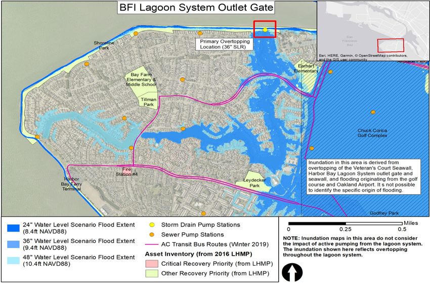
Priority Coastal Inundation Locations | G-15Table G-7. Bay Farm Island Lagoon System 1 North Outlet Gate and Seawall Vulnerability Summary
The Bay Farm Island lagoon system draws water at the southern end and discharges it at the North Outlet Gate, located just west of Bay Farm Island
Bridge. The shoreline at the outlet gate is a narrow isthmus of land that provides flood protection but is not a certified seawall or levee. The outlet
gate is used to manage water levels in the lagoon through a passive tide gate system (currently inoperable) and an active pump. The shoreline in
this area is a critical point of protection for the lagoon system and the homes that surround it.
The lagoon system is at risk of flooding due to issues at the outlet gate, including a slow pump that cannot rapidly lower water levels, an
Key
inoperable tide gate, and deficiencies in the seawall at that location. Overtopping of the shoreline in this area could inundate the lagoon
Issue(s)
system and lead to substantial flooding in surrounding neighborhoods.
Overtopping at the outlet gate seawall is likely at 36” total water level, potentially leading to overtopping of the banks of the lagoon and
Exposure flooding of adjacent neighborhoods. Beyond 36” total water level, floodwaters originating at this location merge with floodwaters from
elsewhere on Bay Farm Island, leading to substantial inundation across the island.
Governance
The City of Alameda assumed maintenance responsibility in 1993 for the dike at the outlet gate, although other entities—including the Harbor
Bay Isle Owner’s Association—own the lagoon retaining walls and tide gate/pump structure. The City can modify the outlet gate and seawall
to protect the lagoon system from flooding. Coordination with relevant Bay Farm Island organizations, including HOAs, is necessary to ensure
the lagoon systems are resilient to climate change in the long term. Replacement of the seawall at this location will likely require permits or
coordination with BCDC, USACE, and the California Department of Fish and Wildlife.
Informational
There is limited information on the structural condition of the outlet pipe or the dike, including the structural makeup of the dike itself, which is
partially built on sunken ships and dredged material.
Sensitivity
Flooding on Bay Farm Island is connected to several sources of overtopping, making it challenging to identify a primary source. More detailed
assessment could help determine the source of flooding, but a coordinated approach to adaptation across Bay Farm Island is warranted.
Functional
Some equipment at the outlet gate and pump is deficient, including the tide gate itself, which is currently inoperable—a pump drains the
lagoon. The pump is undersized to drain the lagoons rapidly, which may be necessary if there is a large storm event on top of sea level rise.
Compounding this, pressure transducers used to measure water levels in the lagoons are inaccurate and unreliable.
Physical
The structural condition of the dike is unknown, and the seawall built on it may be at risk of failure during a large event like an earthquake.
Deficiencies along the interior lagoon retaining walls could also contribute to flooding next to the lagoons.
Operational and physical changes at this site could increase its resilience to sea level rise and storm surge. Relatively minor modifications to
Adaptive
the seawall could provide short-term protection from storm events and remove substantial areas from the FEMA 1 percent annual chance
Capacity
floodplain.
Conse- Social: If the seawall breaches or the lagoon system fails to drain during a storm, many homes and businesses could be flooded.
quences Economic: Flooding next to the lagoon system would impact important roads and cut off access to some neighborhoods on the island.
Priority Coastal Inundation Locations | G-16Priority Coastal Inundation Locations | G-17
Table G-8. Veteran’s Court Seawall Vulnerability Summary
Veteran’s Court is a small road near the Bay Farm Island Bridge touchdown on Bay Farm Island. It connects to Island Drive and serves primarily as
an access road to the shore for maintenance or recreation. Veteran’s Memorial Park is also considered part of this priority shoreline area due to its
importance to flood mitigation strategies. Veteran’s Court itself serves as a conduit for floodwaters if the seawall in this area is breached, potentially
contributing to substantial inundation along Island Drive and adjacent neighborhoods.
The Veteran’s Court area is located within the FEMA 1 percent annual chance floodplain. Overtopping of this shoreline results in flooding at a
Key major intersection on Bay Farm Island (Doolittle and Island Drives). While there are options for adapting this specific section of low-elevation
Issue(s) shoreline, other shoreline areas across Bay Farm Island also overtop at similar water levels. Beyond 36” total water level, a coordinated
response to shoreline overtopping on Bay Farm Island is needed to prevent flooding.
The Veteran’s Court seawall overtops at 36” total water level, below the FEMA base flood elevation (10’ NAVD88). At 48” total water level,
inundation from Veteran’s Court merges with inundation from other overtopped shorelines on Bay Farm Island, making it difficult to determine
Exposure
the exact source of floodwaters. The Veteran’s Court area is likely responsible for some component of flooding at the intersection of Island
Drive and Doolittle Drive.
Governance
The seawall itself is owned by the City but is not accredited by FEMA. Addressing vulnerabilities in this immediate area, especially over the
longer term as water levels continue to rise, would likely require coordination with adjacent private landowners, including the Harbor Bay Club
and adjacent neighborhoods.
Flooding on Bay Farm Island, derived from Veteran’s Court and other locations, impacts State Route (SR) 61 (Doolittle Drive), which Caltrans
owns. Coordination with Caltrans is important to maintain traffic flow along this critical road, one of the primary evacuation routes from
Alameda.
Sensitivity Informational
It is very difficult to determine the exact source of flooding on Bay Farm Island beyond 36” total water level due to overtopping at multiple
locations.
Functional
The presence of other vulnerable spots along the shoreline in this immediate area and more broadly across Bay Farm Island means that fixing
the Veteran’s Court seawall alone will not reduce all local flood vulnerability.
Physical
Alameda’s 2008 Storm Drain Master Plan indicates that seepage is observed along the seawall at high tide.
Adaptive There are multiple options for enhancing flood protection along Veteran’s Court, but construction and engineering of some sort is required;
Capacity however, no immediate or simple modifications to this location could address sea level rise and storm surge.
Social: Community impacts are likely if major transportation routes on Bay Farm Island are blocked. Flooding is also likely to directly impact
Conse- residences and businesses.
quences Economic: Substantial disruption to commuter and commercial transit is likely if Island Drive and/or Doolittle Drive flood.
Environmental: SAV is present immediately adjacent to Veteran’s Court and should be protected.
Priority Coastal Inundation Locations | G-18Priority Coastal Inundation Locations | G-19
Table G-9. Bay Farm Island Bridge Touchdown and Towata Park Vulnerability Summary
The stretch of shoreline near the Bay Farm Island Bridge touchdown on Alameda Island provides flood protection to the adjacent residential area, Bridgeview Isle, and
Krusi Park. Overtopping at this location begins at 24” total water level but does not impact residential areas until a total water level of 36”. The current shoreline is
composed of seawalls and riprap with a mix of City and Raven’s Cove HOA ownership. Towata Park at this location is owned and maintained by the City and is impacted
by flooding by 36” total water level.
Shoreline protection structures in this area currently provide flood protection for surrounding roads, residential neighborhoods, and Krusi and
Key Issue(s) Towata Parks. Floodwater originating in this area may merge with water derived from overtopping in other areas at higher water levels,
leading to substantial inundation that is only addressed with shoreline modifications in several locations.
Minor overtopping of the shoreline directly west of the bridge touchdown on Alameda Island begins at 24” total water level. At 36” total water
level, Bridgeview Isle and some nearby houses are impacted. At 48” total water level and higher, the flood area expands significantly with
Exposure
several important streets and other assets impacted. Flooding at higher water levels could connect with the lagoons, leading to more
widespread inundation.
Governance
Several jurisdictions have oversight of assets near the Bay Farm Island Bridge. The bridge itself is within the Caltrans Right of Way. The
shoreline west of Towata Park is owned by the California Department of Parks and Recreation, while Towata Park is owned by the City.
There is also information suggesting the Raven’s Cove HOA may own parts of the shoreline in this area. Coordination among multiple
agencies is necessary to address shoreline deficiencies in this area.
Informational
Beyond 48” total water level, multiple areas of shoreline overtopping could lead to flooding of large segments in southeastern Alameda Island,
including around the South Shore Lagoons. Because the shoreline overtops at several locations in the same general area, it is not clear
Sensitivity where the majority of floodwaters originate, making it challenging to prioritize actions. The lack of clear information on floodwater source
suggests an integrated approach is necessary for this entire area.
Functional
Shoreline overtopping in this area leads to flooding along Otis Drive, Fernside Drive, and High Street, which all connect to the Bay Farm
Island Bridge and are important connections between Alameda and Bay Farm Island. The bridge is also part of official evacuation routes in
Alameda.
Physical
There are eelgrass beds present in the San Leandro Bay Inlet immediately near the Bay Farm Island Bridge. Any adaptation actions in this
area need to avoid or mitigate impacts to eelgrass and should seek to enhance eelgrass habitat where possible.
Adaptive Adaptation in this area will likely require strategies to be integrated and coordinated across multiple landowners and agencies because
Capacity flooding over the longer term originates from multiple areas of shoreline overtopping.
Social: Bay Farm Island Bridge is an important corridor for commuters, businesses, and emergency response. It is the only direct connection
Conse- between the islands and blocked access would greatly disrupt daily life.
quences Economic: Approximately 40,000 vehicles cross the bridge daily and disruptions would greatly impact the movement of goods and services.
Environmental: Degradation of the adjacent tidal flat and marsh panne could negatively impact nearby SAV.
Priority Coastal Inundation Locations | G-20Location of Bayview
weir and outfall
Priority Coastal Inundation Locations | G-21Table G-10. SR260, Including Webster and Posey Tubes, Vulnerability Summary
SR260 is a critical transportation corridor connecting Alameda and Oakland—the tubes are one of four ways on or off Alameda Island. The historic
average annual daily traffic at the tubes is approximately 31,500, including numerous commercial vehicles, which account for approximately 2.5
percent of daily traffic. The Posey Tube is the second oldest underwater tunnel in the United States (built in 1928) and was added to the National
Register of Historic Places in 2000. Although seismic retrofits were completed in 2004, the age of the tube may increase its vulnerability to climate
impacts. Webster Tube, built in 1963 to ease traffic volume in Posey Tube, is at lower risk of age-related deterioration.
SR260 is essential to the movement of people, goods, and emergency services. However, the tubes are vulnerable to flooding derived from
Key both shoreline overtopping and precipitation events. Mixed jurisdictional oversight of the asset(s) could also pose a barrier to the
Issue(s) implementation of adaptation measures, primarily because Caltrans is not specifically authorized to implement resilience/adaptation projects
(but can incorporate adaptation/resilience into larger transportation projects).
SR260 and the tubes are exposed to sea level rise and storm surge flooding at 36” total water level. Inundation likely originates along the
northern shoreline adjacent to the tubes (as described in the summary for that shoreline area). Overtopping near the Main Street Ferry
Exposure Terminal may also contribute to flooding at the tubes. There is also substantial exposure to storm drain flooding driven by precipitation events
near the entrance to the tubes, with storm drain modeling indicating multiple locations of potential flooding greater than 1 foot above street
level.
Governance
Caltrans owns and maintains SR260 and the tubes. The City of Alameda also has some maintenance responsibility and oversight, particularly
along streets that lead to the tubes.
Informational
The extent of age-related deterioration of the Posey Tube and elements within it (electrical/ventilation systems) is not clear.
Functional
Sensitivity
SR260 is a very high-use transportation corridor that is highly sensitive to disruptions. Traffic rerouting would be incredibly difficult if the tubes
are blocked due to floodwaters, as vehicles would need to be redirected to one of the bridges leading to Alameda.
Physical
Many physical vulnerabilities are associated with the tubes. Notable issues include stormwater pumps that are not corrosion-resistant, and
therefore could become inoperable if saltwater enters the tubes. The tubes themselves are also “immersed” and rely on careful waterproofing
to maintain their function.
Short-term modifications at the ramps to the tubes could reduce the potential for flooding in the tubes; however, new structures would be
Adaptive
required (elevated roadway, floodwalls, etc.). The tubes themselves have very limited adaptive capacity because modifications would be very
Capacity
complicated and require closure during construction.
Social: SR260 and the tubes are critically important to traffic flow on and off Alameda Island. Multiple AC Transit bus routes use the tubes,
Conse- and disruptions could disproportionately impact transit-dependent communities that don’t have alternative transportation options.
quences Economic: Major economic impacts are likely if access to the tubes is blocked.
Environmental: There are known underground and submerged hazardous waste sites along SR260 and adjacent to the tubes.
Priority Coastal Inundation Locations | G-22Table G-11. SR61 (Doolittle Drive and Other Segments) Vulnerability Summary
SR61 is a state highway owned and maintained by Caltrans. The route runs from the intersection with SR112 near Oakland Airport and terminates on
Alameda Island at the intersection of Webster Street and Central Avenue. The road connects Bay Farm Island and Alameda Island across the Bay
Farm Island Bridge. Multiple AC Transit bus routes use SR61, including several that serve transit-dependent or disadvantaged communities. The
City of Alameda has designated SR61 south of Otis Drive as a primary evacuation route and the segment on Alameda Island as critical access for
the evacuation route.
Disruptions to SR61 could have substantial impacts on the flow of commuters and goods within Alameda and to Oakland, including several
Key
important bus routes. Existing traffic issues in Alameda would be exacerbated if the City closes SR61 or restricts traffic flow. Overtopping of
Issue(s)
Doolittle Drive on Bay Farm Island also contributes to broad flooding across the island, with the road serving as a conduit for floodwaters.
SR61 is exposed to flooding from multiple sources of overtopping, including Veteran’s Court seawall, along Doolittle Drive, and at the Bay
Farm Island Bridge touchdown on Alameda Island. Shoreline overtopping begins at around 36” total water level. Precipitation-driven storm
Exposure
drain flooding also impacts SR61—the modeled 25-year storm event results in several areas with water levels greater than 0.5 feet above
street level.
Governance
Caltrans owns and maintains SR61, both in Alameda and Oakland. Flooding along SR61 is also a concern for the City of Oakland and Port of
Oakland, and a coordinated approach to address vulnerabilities is warranted.
Informational
It is very difficult to determine the exact source of flooding on Bay Farm Island beyond 36” total water level due to overtopping at multiple
locations.
Functional
Sensitivity SR61 has very high average daily traffic, and it is very important for travel between the islands and for emergency services. Several
emergency operations staging areas are along SR61.
Major congestion issues exist along SR61 during peak hours, primarily at the junction of Webster Street and Central Avenue, and at Doolittle
Drive and Island Drive. Traffic flow on SR61 is affected by local Alameda surface streets, traffic from SR112, and traffic diverted from I-880 in
Oakland due to construction or accidents. GPS systems like Google Maps and Waze often redirect people onto SR61 if major congestion is
on I-880.
Physical
Overtopping in this area could impact Doolittle Landfill, which is protected by a perimeter levee that has known seepage concerns.
Groundwater impacts to the landfill are also likely.
Adaptive There are multiple options for enhancing flood protection along SR61, but construction and engineering of some sort is required. No
Capacity immediate or simple modifications to this location could address sea level rise and storm surge.
Social: SR61 is used by several AC Transit bus routes that serve transit-dependent communities, and disruptions could result in major delays
to most bus routes in Alameda. SR61 is also a priority evacuation route from Alameda.
Conse-
Economic: Substantial disruption to commuter and commercial transit is likely if SR61 floods.
quences
Environmental: Several species of concern are found along SR61. There are also known underground hazardous waste sites along the
southern end of SR61 and just north of the route on Alameda Island. Contamination could impact Arrowhead Marsh and other sensitive areas.
Priority Coastal Inundation Locations | G-23Table G-12. Critical and High-Use Roadways (Excluding Caltrans Roads) Vulnerability Summary
Many major and minor roads in Alameda are expected to be impacted by flooding and inundation associated with both sea level rise and storm
events. To analyze and present vulnerabilities, key roadways were bundled into a single priority asset group. The common theme for roadways in
this asset group is that they are heavily used by multiple AC Transit bus routes, specifically those that serve transit-dependent or socially vulnerable
communities and provide critical connections between Alameda and the mainland. Although roadways other than those described here are at risk of
damage due to flooding, this assessment prioritized roads that serve as key transit corridors because of their importance to transit-dependent
communities.
Entire roads and specific road segments or intersections in Alameda are exposed to flooding from sea level rise, storm surge, and major
Key rainfall events. Given the limited number of connections between Alameda and the mainland, disruptions to key roads like Webster Street can
Issue(s) have large impacts on transit-dependent residents and commerce. One key vulnerability is the inability of connecting streets in Alameda to
handle additional traffic volume if key roads are closed or restricted and major traffic rerouting is necessary.
Most of the exposure to key roadway segments is due to precipitation-driven, storm drain flooding—some segments are exposed to sea level
rise and storm surge flooding in isolated locations. There is substantial exposure to storm drain flooding as modeled for a 25-year storm event.
Exposure
Flooding greater than 1 foot above street level could occur at multiple locations along key roadways. Heavily impacted roads include Main
Street, Webster Street, Stargell Avenue, Atlantic Avenue, Pacific Avenue, and Otis Drive.
Governance
The City of Alameda is responsible for maintenance and upgrades of almost all roadways except Caltrans-owned SR260 and SR61. However,
the City has very limited control over operational conditions like route alignments for AC Transit. Any route adjustments would be made by AC
Transit in collaboration with the City.
Alameda is a relatively minor component of the AC Transit system, which also serves Oakland, Berkeley, and other cities in Alameda and
Contra Costa counties. AC Transit has four planning districts—Alameda is part of the Northern Alameda County planning area, with a total
population of 616,000, potentially resulting in less attention being paid to the transit system within Alameda except where it is part of a major
Sensitivity transit route like AC Transit Route 51A.
Functional
AC Transit routes have multiple connections with regional transit services (primarily BART) and are heavily used by commuters. The bus
system serves highly transit-dependent and socially vulnerable communities in Alameda Point and adjacent neighborhoods. The entirety of
Route 96 runs through census tracts with high social vulnerability, as defined by a composite of several economic and demographic indicators.
Physical
Location-specific issues on roads contribute to overall vulnerability. For example, stormwater catch basin inlets along Mariner Square Drive
(used by AC Transit Route 96) are lower in elevation than surrounding road sections, leading to flooding during precipitation events.
Adaptive Modifications to roadways are often very expensive and require long environmental review and permitting processes. It may be difficult to
Capacity identify shore-term strategies that allow rapid response to threats.
Social: Multiple AC Transit bus routes serve transit-dependent and disadvantaged communities. Closures or disruptions to roads along these
Conse- routes would limit the ability of these residents to commute to work and go about daily activities.
quences
Economic: Substantial impacts to the transport of goods around Alameda and on/off the islands could occur if key roads are closed/disrupted.
Priority Coastal Inundation Locations | G-24Critical and High-Use Roadways (Bay
Farm Island on next page)
Note: Black boxes indicate priority areas
where storm drain and/or sea level rise-
driven flooding are likely to impact major
Priority Coastal Inundation Locations | G-25Priority Coastal Inundation Locations | G-26
Table G-13. Storm Drain Pipes and Pump Stations Vulnerability Summary
Storm drain pump stations across Alameda are a critical component of the stormwater system and are
expected to become even more important as water levels rise. The pump stations operate in areas that
cannot drain through a gravity system, although it is likely that most of the gravity-fed components of
Alameda’s stormwater system will become obsolete as outfalls are submerged and rising groundwater
impacts hydraulic conditions.
Alameda’s storm drain pump stations are already subject to capacity and operational issues,
Key including flap gate failures, sedimentation, and lack of backup power. While capacity upgrades
Issue(s) have already been identified, the City must consider other modifications at the pump stations to
increase the resilience of the station infrastructure to floodwater.
Shoreline overtopping due to sea level rise and storm surge at multiple locations could lead to
temporary flooding or permanent inundation at storm drain pump stations. Precipitation-driven
Exposure storm drain flooding could also impact the pump stations. The degree of flooding varies from
station to station. Initial exposure at the storm drain pump stations is primarily related to access;
direct impacts to infrastructure are not likely until higher water levels.
Governance
The City of Alameda owns and maintains most of the storm drain pump stations. For those that
are not owned by the City (Harbor Bay Lagoon System stations and Southshore Lagoon inlet
pump), there is a clear division of responsibility for station maintenance.
Informational
None—regular inspections and maintenance result in substantial information related to station
condition.
Functional
Operating storm drain pump stations are a vital component of Alameda’s stormwater system and
their failure would have wide-ranging ripple effects throughout the system.
Sensitivity There are known capacity issues with the overall stormwater system (upgrades planned) that
result in overland flooding across Alameda during heavy precipitation events.
Sea level rise is likely to block some stormwater outfalls, increasing the strain on storm drain
pumps or resulting in pump failure.
Physical
Pump stations contain both electrical and mechanical equipment that floodwaters could damage
(electric motors drive all pumps). The primary risks are for shorted electrical systems or corroded
mechanical equipment.
There are known issues with sedimentation at several pump stations and outfalls, further
reducing their capacity and functionality.
Pump stations were not designed with built-in excess capacity (backup pumps), and several lack
backup power systems.
City ownership of most storm drain pump stations increases their adaptive capacity by removing
Adaptive
barriers to action. The City can take (and is currently taking) some immediate steps to increase
Capacity
the resilience of the stations, including elevating electrical panels.
Social: Malfunctioning storm drain pump stations could lead to flooding across Alameda with
broad impacts even far from the station itself.
Economic: City resources are used to prepare for, handle, and recover from flood events. Flood
Conse-
damage is also a major economic impact.
quences
Environmental: The stormwater system conveys water directly to the Bay. Failure of individual
pump stations could lead to greater overland flow and mobilization of contaminants from the land
surface.
Priority Coastal Inundation Locations | G-27Table G-14. Bayview Weir and Outfall Vulnerability Summary
Water levels in the South Shore Lagoons are maintained by the Bayview weir and outfall, located near the
Elsie Roemer Bird Sanctuary. Water is pumped into the lagoon system at the west end at high tide and
released from the Bayview outfall at low tide to move water through the lagoon system at a rate that
prevents stagnation and water quality issues. The Bayview weir functions as a barrier between lagoon
waters and the Bay. The location of the weir and outfall is shown on the map for Crown Beach and the bird
sanctuary earlier in this appendix.
The Bayview weir and outfall system is an important component of the South Shore Lagoons. An
operational lagoon system is important to maintain water quality and to prevent flooding in
Key communities adjacent to the lagoons. The current weir and outfall are at high risk of sea level
Issue(s) rise and storm surge, and they need major repairs and/or replacement. The greatest vulnerability
to the weir and outfall system is from sea level rise, which will eventually prevent the gravity-fed
system from operating, necessitating an active pump.
The Bayview weir and outfall are directly exposed to flooding from sea level rise, storm surge,
and major rainfall events. Sea level rise compromises the operation of the weir and outfall
system due to its current reliance on gravity flow during low tide. Based on engineering drawings,
Exposure the outfall is roughly equivalent in elevation to mean sea level, or approximately 2 feet above
mean low tide. As a result, 24” of sea level rise (not including storm surge) would likely result in
the outfall structure being regularly submerged except for a short window around low tide. By 36”
total water level, the outfall structure is likely permanently below low tide levels.
Governance
The local HOA owns the lagoon system, but the City of Alameda is responsible for maintaining
water levels. Residents with homes along the lagoon shoreline have a vested interest in a
functioning water level management system.
Informational
Engineering drawings for the outfall structure are old (1959 and 1989) and may not accurately
reflect current water levels and mean tide levels.
Functional
The gravity-fed system relies on low tide to drain water from the lagoons. Sea level rise poses a
direct and imminent risk to this system as currently designed. Even if the outfall was exposed at
Sensitivity low tide in the coming years, rising water levels will reduce the amount of time the City can
discharge water from the lagoons, greatly restricting the flood management capacity of this
system.
The current system design could expose homes surrounding the lagoon system to precipitation-
driven overland flooding if water levels at the outfall are too high to allow for discharge. Increased
storm intensity in the future could exacerbate the risk of overland flooding.
Physical
BCDC inundation maps indicate the South Shore Lagoon system could eventually be directly
connected to the Bay at higher water levels if steps are not taken to protect critical shoreline
segments and improve the weir and outfall system.
Multiple components of the weir are damaged, including an inoperable flap gate and platform
columns.
The existing outfall structure has very limited adaptive capacity because it relies on a gravity flow
Adaptive
system. Raising the outfall to accommodate higher water levels would not be feasible.
Capacity
Installation of a pump station at the weir would greatly decrease the vulnerability of the lagoons.
Social: There is a small chance that the failure of the weir and outfall system could result in
flooding adjacent to the lagoons, threatening residential neighborhoods and critical assets,
Conse- including Alameda Hospital.
quences
Environmental: There is known contaminated sediment in the east lagoon (where the weir is
located).
Priority Coastal Inundation Locations | G-28You can also read