Town of Wasaga Beach Natural Heritage System South Bank Study - Prepared by David Featherstone, Sylvia Anderson and Lisa Moran Nottawasaga Valley ...
←
→
Page content transcription
If your browser does not render page correctly, please read the page content below
Town of Wasaga Beach
  Natural Heritage System

       South Bank Study

     Prepared by David Featherstone,
     Sylvia Anderson and Lisa Moran

Nottawasaga Valley Conservation Authority

              October 2005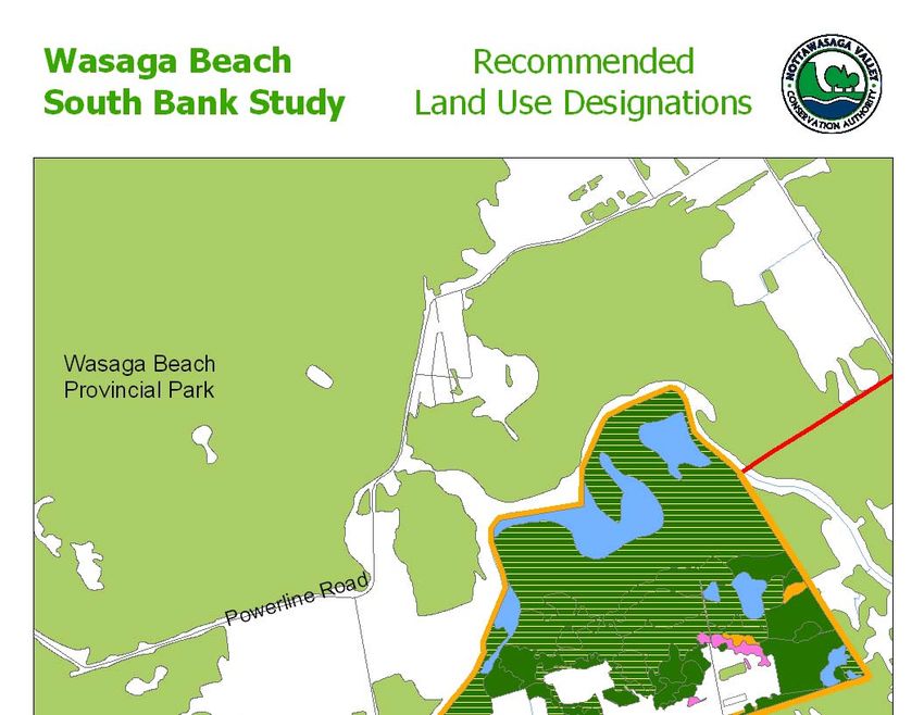
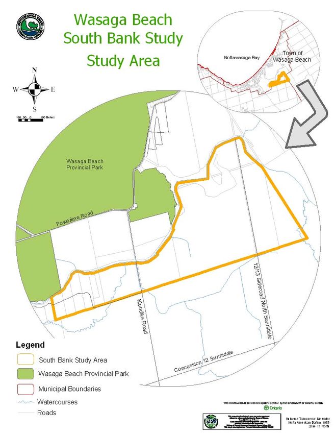
Executive Summary
Background

In spring 2004, the Town of Wasaga Beach entered into an agreement with the Nottawasaga
Valley Conservation Authority (NVCA) to undertake a Natural Heritage System Update and
Review (NVCA, 2004). This review includes a broad, landscape scale natural heritage modeling
exercise covering the entire Town as well as four more detailed study components: Eastern Hog-
nosed Snake Discussion Paper, Shoreline Study, Dune Outlier Study and South Bank Study.

The purpose of this review is to provide the Town with the information and tools necessary to
strike an appropriate balance between land and resource use and the protection of the Town’s
significant natural features and their functions.

Introduction

The South Bank Study Area (SBSA) includes lands identified in Schedule A-5 of the Town of
Wasaga Beach Official Plan extending south of the Nottawasaga River to the Town limits
(approximately 337.3 ha; Figure 1). Forests, wetlands and agricultural fields (active and
abandoned) dominate land use within this rural area.

Portions of the SBSA associated with the Jack’s Lake wetland complex are designated as
Category 1 Lands within the Town Official Plan (OP). Development opportunities within these
designated lands are severely restricted and emphasis is placed on the preservation and protection
of the natural state of these lands to the greatest possible extent. A significant portion of the
SBSA has been designated as Environmental Protection based on flooding considerations. The
remainder of the SBSA has been designated Rural within the OP.

The purpose of the South Bank Study is to provide the Town with background information on the
natural heritage features and functions within the SBSA and provide recommendations for natural
heritage planning purposes. Assessment of data collected during the study provides the basis for
the recommendations provided in the conclusion of the report.

Natural Heritage Planning Designations

Large forest blocks are present along the Nottawasaga River, particularly south of Jack’s Lake.
Portions of this forest cover are associated with the provincially significant Jack’s Lake wetland
complex. These wetland areas also form part of the Wasaga Beach Provincial Park Nature
Reserve Zones ANSI (Area of Natural and Scientific Interest) and the Simcoe County
Greenland system. Provincially significant wetlands are protected through the Planning Act.

Although not regarded as a true natural heritage designation or policy, the MNR Big Picture 2002
project provides guidance regarding the significance of natural heritage core areas and corridors
on the landscape from a southern Ontario perspective. A significant natural core area identified
as part of the MNR Big Picture 2002 mapping exercise is located within the SBSA. This core
area is associated with the linear forest along the Nottawasaga River and the larger, contiguous
forest block extending south of Jack’s Lake.

South Bank Study                                                                            Page i
Nottawasaga Valley Conservation Authority                                              12/21/2006
Field Investigations

Vegetation communities within the SBSA were identified and classified to Vegetation Type using
the vegetation and soil components of the Ecological Land Classification (ELC) protocol (Lee et
al., 1998). This protocol has been developed by the MNR to provide for the consistent
description, identification, classification and mapping of ecological land units in southern
Ontario.

Field work was carried out by NVCA staff in October 2004 and May/June 2005. Natural heritage
features cover over 80% of the SBSA. Forest cover is dominant with cultural meadows
(abandoned farmland), non-treed wetlands and tallgrass prairie forming lesser components of
natural cover. Treed swamps are the dominant vegetation form accounting for just over half of
total natural heritage cover within the study area. Vegetation community work suggests that most
of deciduous, mixed and coniferous cover in the transition zone between the deciduous swamp
and agricultural fields to the south have wetland attributes that may support their inclusion within
the provincially significant Jack’s Lake wetland complex.

Rare Vegetation Communities and Species

Vegetation Communities

Small prairie-savannah communities have developed on abandoned agricultural lands
immediately south of the forest cover east and west of 13th Sideroad. Similar communities were
also documented in similar physiographic settings immediately north of the Nottawasaga River
along Power Line Road as part of the larger natural heritage study undertaken for the Town
(Featherstone et al., 2005).

Fresh-moist tallgrass prairie/savannah is considered very rare from a global perspective and
extremely rare within Ontario. The Significant Wildlife Habitat Technical Guide (MNR, 2000)
states that all provincially rare vegetation communities should be considered significant from a
provincial planning perspective.

Rare Plants

Two regionally rare plant species were observed during site visits in support of this study. Gray
sedge (Carex grayi) was observed in mixed swamp habitats and has been historically documented
in the silver maple swamp associated with the Nottawasaga River floodplain (Brunton, 1989).
Butterfly milkweed was observed in tallgrass prairie habitats. Rough-fruited amaranth
(Amaranthus tuberculatus) has been historically documented in marsh/swamp edge habitats along
the river shoreline (Brunton, 1989). Comprehensive botanical inventories in this area may result
in identification of other rare plant species.

Eastern Hog-nosed Snake

The federally and provincially threatened eastern hog-nosed snake is present within the SBSA.
“Critical habitat” (federal) and “significant habitat” (provincial) of threatened species is protected
through federal and provincial legislation.

The eastern hog-nosed snake is the subject of ongoing research studies directed by Wasaga Beach
Provincial Park staff. This species is also the focus of the Eastern Hog-nosed Snake Discussion

South Bank Study                                                                               Page ii
Nottawasaga Valley Conservation Authority                                                  12/21/2006

Paper (Featherstone and Anderson, 2005). Habitat loss and persecution are the primary threats to
eastern hog-nosed snake in southern Ontario.

The eastern hog-nosed snake requires a number of different habitat types to complete all portions
of its life cycle. Specific habitat types are required for breeding, hibernation, egg deposition,
foraging and shedding. Connectivity to these different habitat types within their home range is
essential for population survival.

Telemetry tracking indicates that eastern hog-nosed snakes are crossing the Nottawasaga River
and that mating may be occurring in the SBSA. Mounting evidence suggests that connected sub-
population of eastern hog-nosed snake is present in the SBSA and vicinity (Cunnington, 2004).
Strong gene flow between this sub-population and the WBPP population increases the genetic
fitness of both populations.

Landscape-level Ecological Functions

The SBSA is part of a larger natural core area that includes the Wasaga Beach Provincial Park
Natural Reserve Zone ANSI, the provincially significant Jacks Lake wetland complex and other
contiguous forested communities. The significance of this core area is recognized in the MNR
Big Picture 2002 mapping project which encompasses contiguous forest cover on the south bank
of the Nottawasaga River.

A variety of vegetation communities are interspersed through the SBSA. These diverse habitats
are connected to Marl Lake to the northeast and other portions of the Jack’s Lake wetland
complex extending south-southeast toward Edenvale and the provincial-scale corridors centred on
the Minesing Wetlands. This interconnected area is capable of support the various life history
stages of a highly diverse wildlife community.

The coniferous and mixed forests within the SBSA support deer wintering habitat that is at least
of local significance. Connectivity and proximity with the MNR-identified deer yard at Wasaga
Beach Provincial Park likely increases the value of this habitat function on the landscape.

Forest interior (deep forest) conditions provide specialized habitats for many neotropical migrant
and interior-specialist bird species, a number of which were observed in May 2005. Herpetiles
such as wood frog and yellow spotted salamander are associated with forest interior habitat.
Mammals such as flying squirrels, porcupines and fisher also require large tracts of forest for
survival.

The SBSA is part of a significant groundwater discharge zone where the groundwater discharges
to wetlands and watercourses as springs or seepage areas. The silver maple swamps and open
wetlands associated with the Nottawasaga River floodplain provide secondary flood control
functions which complement the larger flood control functions of Minesing Swamp. Wetlands
and associated vegetation act as sediment and nutrient sinks, providing important water quality
benefits to the Nottawasaga River system.

NVCA Natural Heritage Model Scoring

The NVCA has undertaken a natural heritage modeling exercise for the Town of Wasaga Beach
(Featherstone et al., 2005). This GIS-based system evaluates and ranks natural areas based on
seven parameters: size, shape, diversity, slope, proximity, groundwater and surface water.

South Bank Study                                                                           Page iii
Nottawasaga Valley Conservation Authority                                              12/21/2006
The model suggests that forest units contiguous with the Nottawasaga River and associated forest
blocks to the north have relatively high natural heritage values within the context of the Town of
Wasaga Beach. This scoring is reflective of their large size, community diversity, proximity to
adjacent natural heritage features and contribution to surface water and groundwater discharge
functions.

Conclusion and Recommendations

The Town of Wasaga Beach Natural Heritage Update and Review project reinforces the
significance of the contiguous forest cover in the SBSA and adjacent natural areas located south
of the Nottawasaga River. Natural heritage modeling indicates that this forest cover is relatively
significant within the Town of Wasaga Beach. Large areas of forest interior habitat as well as
important local, regional and provincial corridor functions have been identified. Field work
undertaken in support of the SBSA has identified the presence additional potential wetland areas
that may be included, subject to MNR review, as part of the Jack’s Lake wetland complex. Three
provincially rare dry tallgrass prairie communities were identified and the presence of regionally
rare vegetation was reconfirmed. Additional rare plant species are potentially present within the
study area. The eastern hog-nosed snake discussion paper, prepared in consultation with the
MNR Parks researchers, identifies that contiguous forest cover associated with the SBSA
provides habitat for this threatened species.

The following recommendations are offered to provide appropriate natural heritage land use
designations and protective policies within the Town of Wasaga Beach Official Plan.
Recommended additions to the Natural Heritage System are depicted in Figure ES-1.

    •   Contiguous forest cover south of Jack’s Lake represents a large core area that supports
        the federally and provincially threatened eastern hog-nosed snake. It is recommended
        that this large core area be designated as Natural Heritage System – Category 1 Lands.
    •   Small areas of tallgrass prairie/savannah/woodland, considered extremely rare within
        Ontario, lie adjacent to the large core forest. It is recommended that these areas be
        designated as Natural Heritage System – Category 1 Lands.
    •   The wetlands identified through this study are functionally part of the provincially
        significant Jack’s Lake wetland complex and meet the tests for proximity set out in the
        Ontario Wetland Evaluation System. Future MNR updates of this wetland complex
        should include these mapping revisions. It is recommended that these wetlands be
        designated as Natural Heritage System – Category 1 Lands
    •   Small plantations and successional vegetation communities provide lesser natural
        heritage values. No changes to existing land use designations are recommended in these
        areas.
    •   Small woodlots isolated from the Nottawasaga River or connected to the river/core area
        by narrow corridors are less significant from a landscape ecology perspective. No
        changes to existing land use designations are recommended in these areas.

South Bank Study                                                                           Page iv
Nottawasaga Valley Conservation Authority                                              12/21/2006
Figure ES-1: Recommended Land Use Designations

South Bank Study                                     Page v
Nottawasaga Valley Conservation Authority        12/21/2006
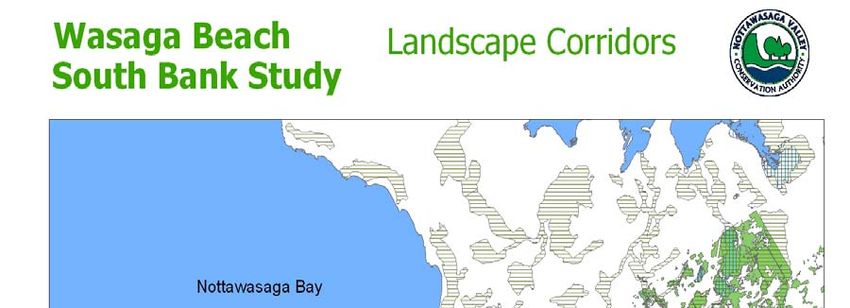
Table of Contents

Executive Summary....................................................................................... i
Table of Contents ......................................................................................... vi
Acknowledgements .................................................................................... viii
1.0 Introduction............................................................................................. 1
2.0 Existing Natural Heritage Designations ............................................... 3
2.1 Provincially Significant Wetland.................................................................................. 3
2.2 Wasaga Beach Provincial Park Nature Reserve Zones ANSI ...................................... 3
2.3 Simcoe County Greenlands........................................................................................... 7
2.4 Town of Wasaga Beach Official Plan........................................................................... 7
2.5 MNR Big Picture 2002 ............................................................................................... 10
3.0 Vegetation Community Mapping........................................................ 12
3.1 ELC Protocol .............................................................................................................. 12
3.2 Vegetation Community Analyses ............................................................................... 12
     3.2.1 Forests .............................................................................................................. 12
     3.2.2 Non-treed Wetlands ......................................................................................... 16
     3.2.3 Non-treed Uplands ........................................................................................... 16
3.3 Rare Vegetation Communities/Species....................................................................... 16
3.4 Wildlife Species at Risk.............................................................................................. 17
3.5 Ecological/Hydrological Functions ............................................................................ 18
3.6 Corridors and Linkages............................................................................................... 19
3.7 Natural Heritage Modeling ......................................................................................... 19
3.8 Model Overlays........................................................................................................... 22
4.0 Conclusion and Recommendations ..................................................... 24
5.0 References.............................................................................................. 26

South Bank Study                                                                                                          Page vi
Nottawasaga Valley Conservation Authority                                                                             12/21/2006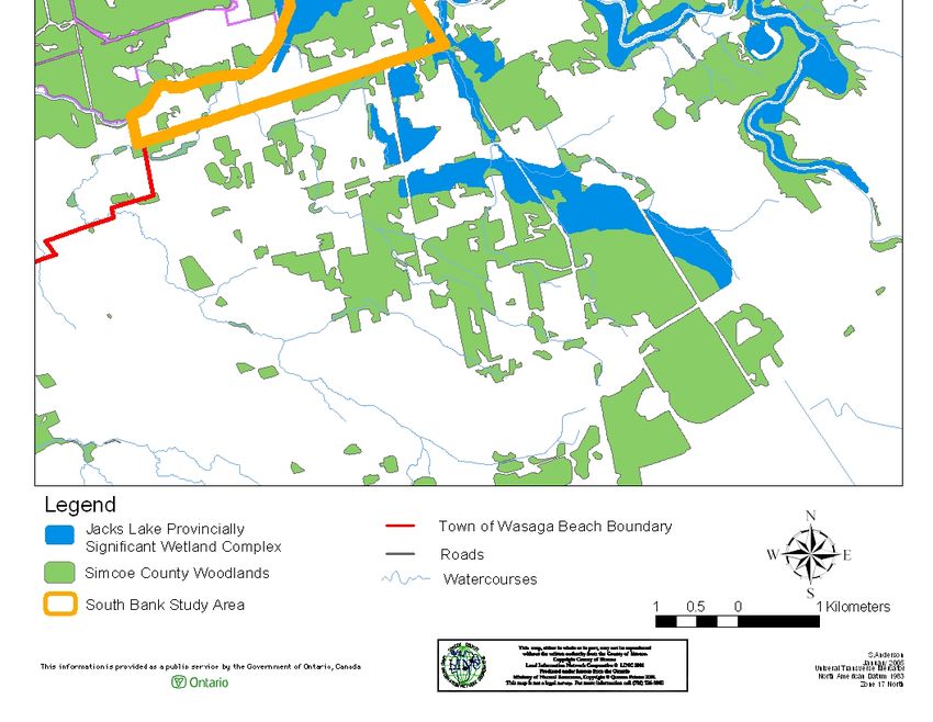
List of Tables

Table 1: ELC Vegetation Types Within the SBSA .......................................................... 14

List of Figures

Figure 1: South Bank Study Area ....................................................................................... 2
Figure 2: Jack’s Wetland Complex..................................................................................... 5
Figure 3: Area’s of Natural and Scientific Interest ............................................................. 6
Figure 4: Simcoe County Greenlands ................................................................................. 8
Figure 5: Schedule “A-5” from the Town of Wasaga Beach’s Official Plan ..................... 9
Figure 6: MNR Big Picture Mapping ............................................................................... 11
Figure 7: Ecological Land Classification for the SBSA ................................................... 13
Figure 8: Landscape Corridors.......................................................................................... 21
Figure 9: South Bank Study Area Natural Heritage Model.............................................. 23
Figure 10: Recommended Land Use Designations........................................................... 25

List of Appendices

Appendix A:         Ecological Land Classification – Vegetation and Soils
Appendix B:         Vegetation List
Appendix C:         Bird List
Appendix D:         Wildlife List

South Bank Study                                                                                                Page vii
Nottawasaga Valley Conservation Authority                                                                    12/21/2006
Acknowledgements
The NVCA would like to acknowledge the support of the individuals and agencies that have
graciously lent their generous support to this study.

The NVCA thanks:

The Town of Wasaga Beach for its dedication to reviewing and updating its natural heritage
mapping and policies.

Tom Young, Dillon Consulting for his peer review of the draft report and contributing to the
strength of the final document.

South Bank Study                                                                         Page viii
Nottawasaga Valley Conservation Authority                                              12/21/2006
1.0 Introduction

The South Bank Study Area (SBSA) includes lands identified in Schedule A-5 of the Town of
Wasaga Beach Official Plan extending south of the Nottawasaga River to the Town limits
(approximately 337.3 ha; Figure 1). An array of land uses is present within this rural area. Large
forest blocks are present along the Nottawasaga River, particularly in the vicinity of Jack’s Lake.
Portions of this forest cover are associated with the provincially significant Jack’s Lake wetland
complex and Simcoe County Greenlands system. Active and abandoned agricultural fields are
found to the south of this forest cover. An unnamed tributary flows along Freethy Road into the
Nottawasaga River in the northwest corner of the study area while another small, unnamed
tributary of the Nottawasaga River flows through the southeast corner of the study area.

The Town of Wasaga Beach has been designated as a Settlement Area in Schedule 5.1 of the
Simcoe County Official Plan. This designation encourages urban forms of development within
the Town which can potentially induce land use planning conflicts between the Town’s
development mandate and its responsibilities with regard to natural heritage protection under the
Provincial Policy Statement (MMAH, 2005). Limited control of urban development within the
SBSA may result in the loss of significant natural heritage features and functions within the Town
with impacts potentially extending beyond the Town boundaries.

In spring 2004, the Town of Wasaga Beach entered an agreement with the Nottawasaga Valley
Conservation Authority to undertake a Natural Heritage System Update and Review (NVCA,
2004). This review includes a broad, landscape scale natural heritage modeling exercise covering
the entire Town as well as three more detailed study components: Eastern Hog-nosed Snake
Discussion Paper, Dune Outlier Study and South Bank Study. Although these four study
components are described separately within the project Terms of Reference, there is significant
synergy between these components with the results of individual component studies affected by
the results of other component studies.

The purpose of this study is to provide the Town with background information on the natural
heritage features and functions within the SBSA. This review builds on the broader natural
heritage modeling exercise by providing more detailed vegetation community data and functional
habitat assessment within this study area. Assessment of this data provides the basis for the
recommendations provided in the conclusion of the report.

This report begins with a description of existing natural heritage designations within the SBSA
followed by a description of vegetation communities based on study field work. This is followed
by an assessment of natural heritage significance, wildlife habitat and corridor function. The
report concludes with natural heritage recommendations for the SBSA.

South Bank Study                                                                            Page 1
Nottawasaga Valley Conservation Authority                                               12/21/2006
Figure 1: South Bank Study Area

South Bank Study                                Page 2
Nottawasaga Valley Conservation Authority   12/21/2006
2.0 Existing Natural Heritage Designations
2.1 Provincially Significant Wetland
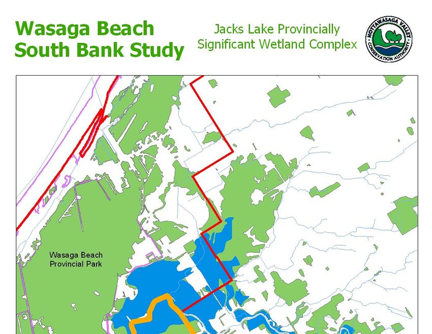
The Jack’s Lake wetland complex is 749.6 ha in size (Figure 2), extending from a core area
associated with Jack’s Lake upstream to Rainbow Valley Road along the Nottawasaga River and
an associated tributary to the west (MNR, unpublished data). This complex is dominated by
deciduous, mixed and conifer swamps (96%). Open water and emergent marshes (4%) are
associated with Jack’s Lake and abandoned oxbows/floodplain areas along the Nottawasaga River
and an unnamed tributary.
The wetland complex supports the following fish and wildlife functions:
• Regionally significant fish habitat
• active feeding areas for colonial waterbirds
• highly significant stopover habitat for migrating birds
• regionally significant waterfowl staging habitat
• locally significant waterfowl production
• locally significant winter deer cover
Within the SBSA, wetland cover associated with this complex consists of deciduous swamp with
narrow bands of emergent marsh along the south shore of Jack’s Lake. The Ministry of Natural
Resources (MNR) has recently undertaken an updated evaluation of this wetland complex. No
significant result wetland boundary changes have occurred within the SBSA although areas to the
west have been significantly revised. Vegetation community work undertaken in support of this
study (Section 3) suggests that most of deciduous, mixed and coniferous cover in the transition
zone between the deciduous swamp and agricultural fields to the south have wetland attributes
that may support their inclusion within the wetland complex. NVCA staff will defer to MNR, as
the lead agency responsible for identifying and evaluating wetland complexes within the
province, for an ultimate decision regarding the inclusion/exclusion of these areas within the
complex. It is possible that these areas may be added to the complex at a later date since wetland
evaluations are open files and can be modified upon receipt and approval of new information.
Provincially significant wetlands are protected through the Planning Act. Section 2.1.3 of the
Provincial Policy statement states that “development and site alteration shall not be permitted in
significant wetland in Ecoregions 5E, 6E and 7E” (MMAH, 2005). The Town of Wasaga Beach
lies within Ecoregion 6E
2.2 Wasaga Beach Provincial Park Nature Reserve Zones ANSI
This provincially significant Area of Natural and Scientific Interest (ANSI; Figure 3) consists of
coincident Life Science and Earth Science features that encompass much of Wasaga Beach
Provincial Park and adjacent (contiguous) natural areas. It is part of a provincially significant
Great Lakes barrier bar and dune complex composed of active beach and rivermouth spit, raised
beaches, transverse/parallel/parabolic dunes, lagoonal sediments and river floodplain (Hanna,
South Bank Study Page 3
Nottawasaga Valley Conservation Authority 12/21/20061984). This ANSI supports provincially significant plant communities and species. Within the SBSA, the ANSI is associated with the river floodplain with its boundary closely corresponding with the wetland boundary associated with the Jack’s Lake wetland complex. ANSIs have a degree of protection under the Planning Act. Section 2.1.4 of the Provincial Policy Statement states that “development and site alteration shall not be permitted in significant areas of natural and scientific interest unless it has been demonstrated that there will be no negative impacts on the natural features or their ecological functions”. South Bank Study Page 4 Nottawasaga Valley Conservation Authority 12/21/2006
Figure 2: Jack’s Wetland Complex

South Bank Study                                Page 5
Nottawasaga Valley Conservation Authority   12/21/2006
Figure 3: Areas of Natural and Scientific Interest

South Bank Study                                         Page 6
Nottawasaga Valley Conservation Authority            12/21/2006
2.3 Simcoe County Greenlands

The County of Simcoe Greenland system is based on a background report entitled “Development
of a Natural Heritage System for the County of Simcoe” (Gartner Lee, 1996). Section 3.7 of the
County of Simcoe Official Plan (2000) states that “the purpose of the Greenland designation is to
ensure that the scale, form and location of development is such that the features and functions of
the natural heritage system are sustained for future generations.” Greenland areas are subject to
policies within the County Official Plan which seek to protect these areas from incompatible
development. Although not specifically referenced within the Town OP, Greenland areas within
the Town are also subject to protective policies pertaining to Natural Heritage System – Category
1 and 2 Lands.

A portion of Greenland Unit WL3 (Lower Nottawasaga River/Jack’s Lake Complex) lies within
the SBSA (Figure 4). This complex unit encompasses much of the Nottawasaga River north of
Minesing Swamp as well as Marl Lake, Jack’s Lake, dune forests associated with Wasaga Beach
Provincial Park and contiguous forest. The Nottawasaga River provides an important greenspace
corridor along its entire length (Gartner Lee, 1996). Within the SBSA, WL3 is associated with the
Jack’s Lake wetland complex and does not include adjacent areas of contiguous forest cover. The
justification for omission of contiguous forest cover is unknown.

The County Official Plan encourages local initiatives to augment the County Greenland system
stating that “locally significant features and functions which support the County Greenlands
system are to be identified and protected in local municipal official plans…”. Therefore, if
significant features and/or functions were identified within these areas and incorporated within
Town OP schedules and policies, they would in turn be incorporated as additions to the Simcoe
County Greenland system.

2.4 Town of Wasaga Beach Official Plan

Section 13 of the Town of Wasaga Beach Official Plan (OP; Town of Wasaga Beach, 2003)
provides land use planning schedules and associated policies for the protection of natural heritage
features within the municipal landscape. The Natural Heritage System is classified into two key
categories.

Natural Heritage System - Category 1 Lands “may be primarily characterized as undeveloped
natural areas of high environmental quality and significance and/or sensitivity”. Lands under this
designation include Provincially Significant Wetlands; natural watercourses and ravines; and,
habitat areas of endangered and threatened species. Development opportunities within these
designated lands are severely restricted and emphasis is placed on the preservation and protection
of the natural state of these lands to the greatest possible extent. Portions of the SBSA associated
with the Jack’s Lake wetland complex are designated as Category 1 Lands within the Town OP
(Figure 5).

South Bank Study                                                                             Page 7
Nottawasaga Valley Conservation Authority                                                12/21/2006
Figure 4: Simcoe County Greenlands

South Bank Study                                Page 8
Nottawasaga Valley Conservation Authority   12/21/2006
Figure 5: Schedule “A-5” from the Town of Wasaga Beach’s Official Plan

South Bank Study                                                             Page 9
Nottawasaga Valley Conservation Authority                                12/21/2006
Natural Heritage System Category 2 Lands “may be characterized as areas of lesser
environmental significance and/or sensitivity, although areas of high environmental quality may
also be present. These areas typically will be both publicly and privately owned”. These areas
include:

    •   Adjacent lands to provincially significant wetlands and other Natural Heritage System –
        Category 1 Lands;
    •   Provincially significant Areas of Natural and Scientific Interest or other combinations of
        habitat or landform which could be essential for scientific research or conservation
        education;
    •   Significant habitat of vulnerable or rare species;
    •   Forests, woodlots, rare or other unique and specialized significant biologically sensitive
        wildlife habitat;
    •   Natural connections through valley corridors of other linkages between core areas of the
        Natural Heritage System; and,
    •   Shoreline areas and areas of Natural Fish Habitat.

Development is permitted in Natural Heritage System – Category 2 Lands if it can be
demonstrated through an Environmental Impact Assessment that no negative impacts will occur
to the ecological features or functions of the components of the Natural Heritage System. No
Category 2 Lands have been designated within the SBSA.

A significant portion of the SBSA has been designated as Environmental Protection based on
flooding considerations (Figure 5). The remainder of the SBSA outside of the Environmental
Protection and Natural Heritage System designations has been designated Rural within the OP.

2.5 MNR Big Picture 2002

Although not regarded as a true natural heritage designation or policy, the MNR Big Picture 2002
project provides guidance regarding the significance of natural heritage core areas and corridors
on the landscape from a southern Ontario perspective. The purpose of this project is to identify
high-value core natural areas and highest probability linkages using a replicable, rule-based
model. The model was targeted to include >30% of the non-urban area within each ecological
district. Minimum core sizes of 200 ha were used south of the Canadian Shield and also included
viable occurrences of provincially and globally rare species and communities. Minimum corridor
width of 200 m was used within the model. The Big Picture 2002 project is intended to map
natural heritage cores and linkage at a regional scale. The project team noted that natural heritage
planning is still needed at local levels and that alternate core and linkage criteria and weighting
could be explored.

A significant natural core area identified as part of the MNR Big Picture 2002 mapping exercise
is located within the SBSA (Figure 6). Although scale limitations of the Big Picture mapping
must be considered, it appears that the core area is associated with the linear forest along the
Nottawasaga River and the larger, contiguous forest block extending south of Jack’s Lake.

South Bank Study                                                                            Page 10
Nottawasaga Valley Conservation Authority                                                12/21/2006
Wasaga Beach South Bank Study
MNR Big Picture Mapping
Legend
Cores and Nearby Natural/Values
Linkages – non-natural portion
Linkages – natural portion
Island Cores
Figure 6: MNR Big Picture Mapping
South Bank Study Page 11
Nottawasaga Valley Conservation Authority 12/21/20063.0 Vegetation Community Mapping 3.1 ELC Protocol Vegetation communities within the SBSA were identified and classified to Vegetation Type using the vegetation and soil components of the Ecological Land Classification (ELC) protocol (Lee et al., 1998). This protocol has been developed by the MNR to provide for the consistent description, identification, classification and mapping of ecological land units in southern Ontario. The boundaries of vegetation communities were originally defined via interpretation of 1:10,000 1998 infrared aerial photography. During study revisions, 2002 digital orthophotography became available for the entire SBSA and this was used to refine aerial photography interpretation. As per the ELC protocol, a minimum of two forestry prism sweeps and two soil samples were taken within each identified polygon to classify each community to Vegetation Type (Figure 7). Site reconnaissance activities were carried out on October 4, 2004. Field work, including forestry prism sweeps, botanical and incidental wildlife observations was performed on October 13, 14, 19 and 22, 2004. Supplemental field work was undertaken on May 25, 26 and June 3, 2005. The results of this field work are provided in Appendices A and B and E. It was not the intent of this study to undertake a comprehensive botanical inventory within the SBSA but, rather, to obtain vegetation community information suitable for ELC classification. Therefore, these lists should not be considered as comprehensive inventories. 3.2 Vegetation Community Analyses Natural heritage features cover approximately 81.4% of the SBSA (274.3 ha; Table 1). Forest cover (including upland/bottomland forest, plantation, cultural woodland and treed swamp) dominates natural heritage cover (72.5%) with cultural meadows (abandoned farmland; 14.4%), non-treed wetlands (11.1%) and tallgrass prairie (1.4%) forming lesser components of cover. Treed swamps are the dominant vegetation form accounting for 72.5% of all forest cover and 52.0% of total natural heritage cover within the study area. Wetlands, including treed swamps and non-treed wetlands, account for 63.3% of total natural heritage cover. A discussion of forests, non-treed wetlands and non-treed upland communities is provided below. 3.2.1 Forests Large tracts of silver maple swamp are located within the Nottawasaga River floodplain. These communities are seasonally inundated by the river with high water marks in excess of 1 m on many trees. These tracts are broadly encompassed within the Jack’s Lake wetland complex. Saturated marl and organic soils to the south support mineral deciduous, mixed and coniferous swamps. Organic coniferous swamps have developed immediately south of Jack’s Lake. Fresh- moist deciduous and mixed forests lie at the south end of the forest block between the swamps and the agricultural/successional lands to the south. Most of these fresh-moist forests exhibit seasonally high water tables and a mix of upland and wetland species. The Simcoe County Forest plantations in the southeast corner of the study area overlie relatively well-drained sands. Cultural (successional) woodland features are relatively minor forested elements in the SBSA. South Bank Study Page 12 Nottawasaga Valley Conservation Authority 12/21/2006
Figure 7: Ecological Land Classification for the SBSA

South Bank Study                                           Page 13
Nottawasaga Valley Conservation Authority               12/21/2006
Table 1: ELC Vegetation Types Within SBSA
Vegetation Type                                     ELC Code   Area       % SBSA      % Natural Heritage   Global/Provincial
                                                               Coverage   (337.0 ha   Cover SBSA (274.3    Rarity Ranking
                                                               (ha)       total)      ha total)
FOREST
Fresh-Moist White Cedar Coniferous Forest           FOC4-1     2.2        0.7         0.8                  G4/S5
Dry-Fresh Sugar Maple Deciduous Forest              FOD5-1     4.2        1.2         1.5                  G5/S5
Fresh-Moist Sugar Maple-Lowland Ash Deciduous       FOD6-1     1.1        0.3         0.4                  G?/S5
Forest
Fresh-Moist White Elm Lowland Deciduous Forest      FOD7-1     2.4        0.7         0.9                  G?/S4S5**
Fresh-Moist Ash Lowland Deciduous Forest            FOD7-2     3.7        1.1         1.3                  G?/S4S5**
Fresh-Moist Poplar Deciduous Forest                 FOD8-1     7.8        2.4         2.9                  G?/S5*
Dry-Fresh Hardwood-Hemlock Mixed Forest             FOM3-1     3.9        1.1         1.4                  G4G5/S4S5
Fresh-Moist White Cedar-Hardwood Mixed Forest       FOM7-2     7.7        2.3         2.8                  G?/S5*
Fresh-Moist Poplar-White Birch Mixed Forest         FOM8       0.7        0.2         0.3                  G?/S4S5**
Coniferous Plantation                               CUP3       5.6        1.6         2.0                  -
Red Pine Coniferous Plantation                      CUP3-1     9.3        2.8         3.4                  -
White Spruce–European Larch Coniferous Plantation   CUP3-8     5.6        1.7         2.0                  -
Mineral Cultural Woodland                           CUW1       1.7        0.5         0.6                  -
White Cedar Mineral Coniferous Swamp                SWC1-1     1.6        0.5         0.6                  G?/S4S5**
White Cedar Organic Coniferous Swamp                SWC3-1     10.4       3.1         3.8                  G4G5/S4S5
Black Ash Mineral Deciduous Swamp                   SWD2-1     10.0       3.0         3.6                  G4/S5
Silver Maple Mineral Deciduous Swamp                SWD3-2     93.4       27.7        34.1                 G?/S4S5**
White Birch Poplar Mineral Deciduous Swamp          SWD4-3     5.1        1.5         1.9                  G5/S5
Silver Maple Organic Deciduous Swamp                SWD6-2     1.8        0.5         0.7                  G?/S4S5**
White Birch-Poplar Organic Deciduous Swamp          SWD7-1     4.4        1.3         1.6                  G?/S4S5**
White Cedar-Hardwood Mineral Mixed Swamp            SWM1-1     2.2        0.6         0.8                  G4?/S5
White Cedar-Hardwood Organic Mixed Swamp            SWM4-1     14.1       4.2         5.1                  G?/S4S5**
Total Upland Forest                                            55.9       16.6        20.3
Total Treed Swamp                                              143.0      42.4        52.2
NON-TREED WETLAND
Reed-canary Grass Mineral Meadow Marsh              MAM2-2     6.8        2.0         2.5                  G?/S4S5**

South Bank Study                                                                                                      Page 14
Nottawasaga Valley Conservation Authority                                                                          12/21/2006
Vegetation Type ELC Code Area % SBSA % Natural Heritage Global/Provincial
Coverage (337.0 ha Cover SBSA (274.3 Rarity Ranking
(ha) total) ha total)
Narrow-leaved Sedge Mineral Shallow Marsh MAS2-3 1.6 0.5 0.6 G4/S5
Forb Mineral Shallow Marsh MAS2-9 3.6 1.1 1.3 G?/S4S5
Mixed Shallow Aquatic SAM1 15.4 4.6 5.6 G?/S4S5**
Willow Mineral Thicket Swamp SWT2-2 3.0 0.9 1.1 G?/S4S5**
Total Non-Treed Wetland 30.4 9.1 11.1
NON-TREED UPLAND
Dry-Moist Old Field Meadow CUM1-1 39.6 11.8 14.4 G?/S4S5**
Mineral Cultural Savannah CUS1 1.7 0.5 0.6 G?/S4S5**
Dry Tallgrass Prairie TPO1-1 2.2 0.6 0.8 G3/S1
Fresh-Moist Tallgrass Savannah TPS2 1.5 0.4 0.6 G?/S1*
Total Non-Treed Upland 45.0 13.3 16.4
Total Non-Natural Cover 62.7 18.6 -
TOTAL 100 100
G3 either very rare and local throughout its range or found locally (even abundantly at some of its locations) in a restricted range (eg. a single province or
physiographic region) or because of other factor(s) making it vulnerable to extinction throughout its range; in terms of occurrences, in the range of 21 to
100.
G4 apparently secure globally
G4G5 insufficient information exists to accurately assign a single rank
G5 demonstrably secure globally
G? insufficient information on which to properly determine rank
S1 extremely rare in Ontario; usually 5 or fewer occurrences in the province, or very few remaining remaining hectares.
S4 apparently secure in the province
S4S5 insufficient information exists to accurately assign a single rank
S5 demonstrably secure in the province
* no ranking provided in NHIC website and provincial ranking based on authors’ experience
** no ranking provided in NHIC website
South Bank Study Page 15
Nottawasaga Valley Conservation Authority 12/21/20063.2.2 Non-treed Wetlands Non-treed wetlands make up a small portion (9.1%) of the SBSA. These areas are associated with Jack’s Lake, occasional meadow marsh and swamp thicket communities that have developed on cutover areas and open wetland communities associated with the tributary in the southeast corner of the study area. Most of these wetland units are associated with the Jack’s Lake wetland complex. 3.2.3 Non-treed Uplands Successional old field communities have developed over tracts of abandoned agricultural lands. Lack of shrub and successional tree cover within most of these units indicates relatively recent abandonment. Small areas of fresh-moist tallgrass prairie/savannah are present within the SBSA. Areas with well-drained/excessively drained sandy soils and a history of fire disturbance, such as Wasaga Beach, are typically associated with prairie habitat. However, prairie/savannah vegetation can also develop on fresher habitats such as those within the South Bank study area. There is approximately 3.7ha of fresh-moist tallgrass prairie habitat in the SBSA (Figure 7). Key indicator species include little bluestem (Schizachyrium scoparium), Indian grass (Sorghastrum nutans) and butterfly milkweed (Asclepias tuberosa). 3.3 Rare Vegetation Communities/Species With the exception of fresh-moist tallgrass prairie/savannah units, all vegetation communities within the SBSA are considered apparently secure or demonstrably secure from a global and provincial perspective. Rare dry oak-pine forest/savannah and sand barren communities associated with the transverse and parabolic dune systems within and adjacent to, Wasaga Beach Provincial Park are not present within the study area. Well-drained sandy soils and documented wildfires provide suitable conditions for the establishment of rare, fire-adapted vegetation communities such as prairie/savannah within, and adjacent to, the parabolic and transverse sand dune systems in the Town of Wasaga Beach. Fresh-moist prairie-savannah communities have also developed on abandoned agricultural lands to the south of the parabolic dunes. These communities were also documented in similar physical settings immediately north of the Nottawasaga River along Power Line Road as part of the larger natural heritage study undertaken for the Town (Featherstone et al, 2005). Many of these fresh- moist prairie/savannah habitats are undergoing succession with white cedar (Thuja occidentalis), trembling aspen (Populus tremuloides) and common juniper (Juniperus communis) becoming dominant as these communities age. It is possible that, in the absence of vegetation management, that these features will lose their prairie-savannah characteristics over time. Fresh-moist tallgrass prairie/savannah is considered very rare and/or local (G3) from a global perspective and extremely rare (S1) within Ontario. Prairies are open communities that are dominated by grasses and forbs. Though typically associated with the Prairies and Great Plains, tallgrass prairie and savannah habitat once covered approximately 1,000 km2 in southern Ontario. These communities are associated with well-drained sandy sites subject to environmental stresses, typically fire and drought, through both natural and cultural processes. The vast majority of these South Bank Study Page 16 Nottawasaga Valley Conservation Authority 12/21/2006
communities have been lost over the past 200 years through site land use alteration associated
with agriculture and urbanization. Currently, less than 3% of this habitat remains, generally in
small patches scattered throughout the southern Ontario. Today, these communities are
considered globally rare to imperiled ecosystems (ranked G3 to G1) and are extremely rare
(ranked S1) in Ontario. The Significant Wildlife Habitat Technical Guide (2000) states that all
provincially rare vegetation communities should be considered significant as defined under the
Provincial Policy Statement (MMAH, 2005). The Provincial Policy Statement (MMAH, 2005)
states that “development and site alteration shall not be permitted in significant wildlife habitat
unless it has been demonstrated that there will be no negative impacts on the natural features or
their ecological functions”.

Two regionally rare plant species were observed during site visits in support of this study. A gray
sedge (Carex grayi) was observed in mixed swamp habitats and has been historically documented
in the silver maple swamp associated with the Nottawasaga River floodplain (Brunton, 1989).
Butterfly milkweed was observed in dry tallgrass prairie habitats. Rough-fruited amaranth
(Amaranthus tuberculatus) has been historically documented in marsh/swamp edge habitats along
the river shoreline (Brunton, 1989). Comprehensive botanical inventories in this area may result
in identification of other rare plant species.

3.4 Wildlife Species at Risk

Eastern Hog-nosed Snake

The federally and provincially threatened eastern hog-nosed snake is present within the SBSA.
“Critical habitat” (federal) and “significant habitat” (provincial) of threatened species is protected
through federal and provincial legislation. The Provincial Policy Statement (MMAH, 2005)
states that “development and site alteration shall not be permitted in significant habitat of
endangered and threatened species”.

The eastern hog-nosed snake is the subject of ongoing research studies directed by Wasaga Beach
Provincial Park staff. This species is also the focus of the Eastern Hog-nosed Snake Discussion
Paper (Featherstone and Anderson, 2005). Habitat loss and persecution are the primary threats to
eastern hog-nosed snake in southern Ontario.

The eastern hog-nosed snake requires a number of different habitat types to complete all portions
of its life cycle. Specific habitat types are required for breeding, hibernation, egg deposition,
foraging and shedding. A specialist predator, the eastern hog-nosed snake depends on American
toad for the majority of its diet; therefore, connectivity of foraging areas to wetland breeding
areas is essential. To access these various habitats, eastern hog-nosed snake have relatively large
home ranges that are up to 435 ha in size. Connectivity to these different habitat types within
their home range is essential for population survival. Fragmentation of habitat by roads and
changes in land use can effectively isolate eastern hog-nosed snakes from required habitat types
leading to the declines and ultimate extirpation of specific populations on the landscape
(Featherstone and Anderson, 2005).

In contrast to roads, watercourses do not pose a barrier to eastern hog-nosed snake movement.
Telemetry tracking indicates that mating may be occurring in habitats located south of the
Nottawasaga River including lands in the vicinity of Jack’s Lake suggesting that there may be a
connected population of eastern hog-nosed snake in the forests and wetlands in this area
(Cunnington, 2004). Evidence of habitat populations and connections continues to mount south

South Bank Study                                                                              Page 17
Nottawasaga Valley Conservation Authority                                                  12/21/2006
of Jack’s Lake. A large adult female was observed in April 2005 near 12th Concession and 13th
Sideroad. This early spring sighting indicates that hibernacula area available in this area
(possibly on the Nipissing beach ridge). A large male snake has also been documented just to the
south of this area. The presence of this population outside of WBPP and observed movements
between WBPP and the area south of Jack’s Lake is indicative of strong gene flow between these
areas that increased the genetic fitness of both populations.

Great Gray Owl

A great gray owl was observed along perched along the edge of a young aspen forest near the
northern terminus of 13th Sideroad on January 17, 2005 (D. Featherstone, pers.obs.). The great
gray owl is considered a provincial Species of Concern; however, it is not considered at risk at the
national level. Low populations of their preferred prey, meadow vole, in their boreal
forest/muskeg habitat have resulted in a significant irruption of great gray owl into southern
Ontario this winter in search of food. These irruptions occur on an irregular basis and the owls
will eventually return to their preferred boreal habitat.

3.5 Ecological/Hydrological Functions

The SBSA is part of a larger natural core area associated with the Wasaga Beach Provincial Park
Natural Reserve Zone Area of Natural and Scientific Interest (ANSI), the provincially significant
Jacks Lake wetland complex and contiguous forested communities. This larger core area is
approximately 650 ha in size and is not bisected by roads which are a significant factor for the
movement of some wildlife species such as eastern hog-nosed snake. The significance of this
core area is recognized in the MNR Big Picture 2002 mapping project which encompasses
contiguous forest cover on the south bank of the Nottawasaga River.

A variety of vegetation communities are interspersed through the SBSA. This diversity,
combined with connectivity to Wasaga Beach Provincial Park and contiguous communities
immediately north of the Nottawasaga River, contiguous communities extending through Jack’s
Lake to Marl Lake to the northeast, and contiguous forest cover extending along the Nottawasaga
River tributary to the south-southeast provides a multitude of contiguous, interconnected habitat
types that are capable of support the various life history stages of a highly diverse wildlife
community. The eastern hog-nosed snake, a federally and provincially threatened species,
utilizes a variety of habitat types within, and adjacent to, the SBSA to fulfill its specific life
history requirements (Section 3.4). Although not depicted in MNR deer wintering area mapping,
the coniferous and mixed forests within the SBSA support deer wintering habitat that is at least of
local significance. Connectivity and proximity with the identified deer yard at Wasaga Beach
Provincial Park likely increases the value of this habitat function on the landscape. Significant
yarding activity (trails, pellets) was observed in the coniferous swamps in May 2005.

This core area supports large area of forest interior habitat. Forest interior is defined as forest
habitat more than 100 m from a forest edge. Compared to edge areas, forest interior habitat
provides a relatively moderate microclimate, decreased levels of nest predation and parasitism
and fewer anthropogenic impacts (i.e. pets, light, noise, encroachment). These conditions provide
specialized habitats for many neotropical migrant and interior-specialist bird species, a number of
which were observed in May 2005 (Appendix C). Herpetiles such as wood frog and yellow
spotted salamander are associated with forest interior habitat. Mammals such as flying squirrels,
porcupines and fisher also require this specialized habitat.

South Bank Study                                                                            Page 18
Nottawasaga Valley Conservation Authority                                                12/21/2006
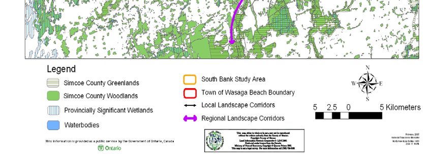
The SBSA is part of a significant groundwater discharge zone where the groundwater discharges
to wetlands and watercourses as springs or seepage areas. The silver maple swamps and open
wetlands associated with the Nottawasaga River floodplain provide secondary flood control
functions which complement the larger flood control functions of Minesing Swamp, located
upstream of the SBSA. These areas effectively store flows during high flow periods and release
them slowly thereby moderating river flow regimes. Wetlands and associated vegetation act as
sediment and nutrient sinks, providing important water quality benefits to the Nottawasaga River
system. Natural areas immediately adjacent to the Nottawasaga River and tributary stabilize
streambanks and provide important nearshore shading and fish habitat structure.

3.6 Corridors and Linkages

Ecosystems cannot be considered in isolation because life moves and changes across landscapes.
The connections between habitat patches and the distances between patches are important.
Biodiversity can only be maintained if effective dispersal between patches is occurring (Larson et
al., 1999). Effective dispersal between patches occurs through natural corridors and linkages.

Corridors are generally elongated, naturally-vegetated areas that link or border natural areas
within and between watersheds (Riley and Mohr, 1994). They provide critical passage for
animals which require a variety of habitats to survive (i.e. eastern-hognosed snake) and their
definition may shift depending on the species of interest. Corridors are important because they
provide connections to larger core natural areas thereby allowing for the movement of species and
provides for genetic exchange and long term viability of wildlife communities within these
regions.

Properly designed corridors and linkages may counter the effects of habitat fragmentation since
the viability of habitat islands (i.e. woodlots) as suitable wildlife habitat often depends on outside
recruitment of animals (Noss, 1987a, b). In southern Ontario, the re-establishment of corridors
over time may lead to the re-colonization and range expansion of species which were extirpated
or suffered significant range contractions since European settlement (i.e. river otter, fisher).
Corridors with a minimum width of 200 m are of highest value and facilitate the safe movement
of most wildlife species (Gartner Lee, 1996; MNR, 2000)

The SBSA is part of a much larger natural heritage system network that is significant at a local,
regional and provincial scale (Figure 8). Locally, the SBSA is contiguous with natural heritage
features associated with Wasaga Beach Provincial Park, Marl Lake and the Jack’s Lake wetland
complex. Regionally, the SBSA is part of a larger core area that is connected via the
Nottawasaga River Valley to Minesing Swamp to the southeast as well as natural heritage areas
along the east shore of Nottawasaga Bay to the north-northeast and natural features extending
northeast along Marl Creek toward Orr Lake. Via regional connections to the southeast and
northeast, this core area is also connected with the Niagara Escarpment-Canadian Shield corridor
which extends northeast from the Niagara Escarpment through the Pine River Valley, Minesing
Swamp and Oro Moraine to the Canadian Shield. This corridor should be viewed as significant
within a provincial context.

3.7 Natural Heritage Modeling

The NVCA has undertaken a natural heritage modeling exercise for the Town of Wasaga Beach
(Featherstone et al., 2005). This GIS-based system evaluates and ranks natural areas based on

South Bank Study                                                                              Page 19
Nottawasaga Valley Conservation Authority                                                  12/21/2006
seven parameters: size, shape, diversity, slope, proximity, groundwater and surface water. After
applying this scoring system, each natural feature receives a score based on the combination of
these weighted parameters. The resulting score ranges from 80 – 500 with higher scores
associated with higher ecological significant and function on the landscape.

The NHS model was developed to be integrative and include a range of terrestrial and aquatic
parameters. The intent of this model is to integrate natural features on the landscape including
core areas and connecting links which support significant vegetation features, fish and wildlife
habitat and groundwater and surface water systems. From a human perspective, this model
supports a natural heritage system that supports human amenities such as drinking water, clean
air, recreation and community aesthetics.

South Bank Study                                                                        Page 20
Nottawasaga Valley Conservation Authority                                            12/21/2006
Figure 8: Landscape Corridors

South Bank Study                               Page 21
Nottawasaga Valley Conservation Authority   12/21/2006
Although the model attempts to integrate landscape level components recognized within the PPS
and supporting documents, it is recognized that important PPS features may not be fully captured
within the model. These features include significant valleylands, hazard lands, old growth
forests, provincial rare species/vegetation communities and species at risk. For example,
floodplain areas dominated by heavy agricultural activity may not score highly within the NHS
model but are landscape constraints that should be mapped as part of the system. Databases for
rare species/communities, species at risk and old growth forests are incomplete, hence their
exclusion from the model; however, where known, habitat associated with these features should
be recognized as part of the system regardless of NHS scoring. These types of features can be
overlain on the scored NHS model.

The modeled scores for natural heritage features within the SBSA range from 170 for the
successional fields located in the south portion of the study area to 425 for the forest cover along
the Nottawasaga River in the northwest portion of the study area (Figure 9). The large,
contiguous block of forested habitat located south of Jack’s Lake received a score of 380. The
model suggests that forest units contiguous with the Nottawasaga River and associated forest
blocks to the north have relatively high natural heritage values within the context of the Town of
Wasaga Beach. This scoring is reflective of their large size, community diversity, proximity to
adjacent natural heritage features and contribution to surface water and groundwater discharge
functions.

3.8 Model Overlays

Overlays of existing environmental designations and ecological functions on natural heritage
features within the study area indicate a number of points:

    •   The MNR Big Picture initiative incorporates the large blocks of habitat south of Jack’s
        Lake within a core area
    •   The provincially significant Life Science ANSI and Natural Heritage System – Category
        1 lands designations do not include the full suite of wetlands and significant core
        area/corridor supported in the SBSA
    •   The Nottawasaga River floodplain, consisting Environmental Protection and Natural
        Heritage System – Category 1 Lands in Schedule A-5, incorporate most of the significant
        natural heritage features within the SBSA.
    •   Eastern hog-nosed snake habitat is associated with high value natural heritage features
        within the SBSA. This habitat underscores the importance of these features on the
        landscape.
    •   With the exception of butterfly milkweed, rare vascular plants are associated with high
        value natural heritage features
    •   the provincially rare tallgrass communities have a lower value natural heritage value from
        a landscape ecology perspective but are significant due to their extreme rarity. These
        communities are contiguous with forest cover in the SBSA.

South Bank Study                                                                            Page 22
Nottawasaga Valley Conservation Authority                                                12/21/2006
You can also read