Severe Weather & Tornado Activity (March 30-31, 2022) Arkansas - WSP USA ...
←
→
Page content transcription
If your browser does not render page correctly, please read the page content below
April 1, 2022
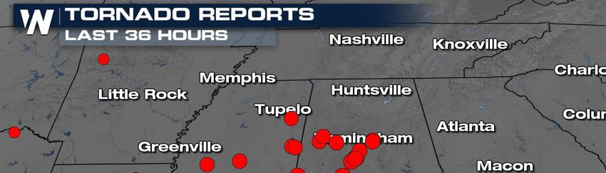
Severe Weather & Tornado Activity (March 30-31, 2022)
Arkansas
· An estimated 60 homes in Springdale received
significant damage Wednesday morning when
an EF3 tornado cut a five-mile path through the
eastern part of the city.
· The tornado touched down in Johnson at 4:04
a.m. near the Northwest Arkansas Mall and ran
for 5.2 miles before lifting at 4:12 a.m. to the
east of the Springdale Municipal Airport,
according to the National Weather Service in
Tulsa, Okla. The tornado had top wind speeds of
143 mph, the service reported.
· The Weather Service crew in Springdale reported the tornado there was 350 yards wide.
· The storm also spawned a second tornado Wednesday, according to the weather service. An EF-
1 tornado tore through a rural area of Johnson County about 3½ hours after Springdale was
struck, said Willie Gilmore, a meteorologist with the National Weather Service in North Little
Rock.
Mississippi
· The Mississippi Emergency Management Agency is working with counties across the state to
assess damage from the severe weather that hit the state on March 30.
· According to MEMA, there have been multiple reports of homes damaged, trees down and
power outages due to straight-line winds and possible tornadoes.
· There have been three injuries reported to MEMA as of Thursday, with two of those being in
Noxubee County and one being in Holmes County.
· MEMA said they are working on initial damage assessments in 21 counties. So far, counties that
have seen the most significant damage include Hinds, Bolivar, Calhoun, Warren and Yazoo.
Alabama
· A line of severe storms moved through central Alabama Wednesday night, spawning five
tornadoes and leaving damage behind in several counties.
· The National Weather Service confirmed an EF-1 tornado with max winds of 110 mph touched
down just before midnight in Shelby County and stayed on the ground for more than four miles
before lifting at 12:06 a.m.
· The NWS also has confirmed EF-2 damage in central Bibb County and Montevallo in southwest
Shelby County. The tornado's path stretched for just over 29 miles, beginning in Oakmulgee in
Perry County and ending at the University of Montevallo in Shelby County.
· A brief EF-1 tornado was confirmed in Tuscaloosa County near Holt Lock and Dam and the
Deerlick Creek Campgrounds. The NWS said that tornado was on the ground for approximately
six minutes.
1 The Daily DART is a publication of WSP USA Inc. All rights are reserved.
Any unauthorized use, disclosure, viewing, copying, alteration, dissemination or distribution without permission is strictly prohibited.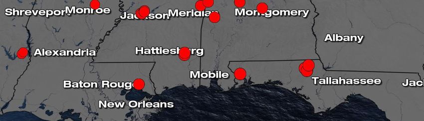
April 1, 2022

    ·     An EF-2 tornado was also on the ground for six miles in Perry County from Hamburg to Radford
          and EF-1 tornado damage was confirmed in Pickens County near Benevola Road.
Florida
    ·     Two people are dead, and two others are hurt after a tornado struck in the Florida Panhandle on
          Thursday morning, authorities said -- part of a series of storms that have laid waste to buildings
          around the South since Wednesday.
    ·     A tornado struck Washington County, north of Panama City, sheriff's spokesperson Kristy
          Kolmetz said.
    ·     "There's a total destruction of homes in that area," Kolmetz told CNN. The conditions of the two
          injured people weren't immediately available.
    ·     At least one tornado was reported before sunrise in an eastern portion of Washington County,
          about a 45-minute drive north-northeast of Panama City, according to the National Weather
          Service.

Severe Weather Outlook
    ·     AccuWeather meteorologists expect April to
          follow in March's footsteps as the table is set
          for another round of severe thunderstorms,
          including possible tornadoes, across the
          South next week.
    ·     The tornado risk may be accompanied by a
          heightened flash flood danger.
    ·     A dip in the jet stream across the center of
          the country early next week is expected to
          bring a storm from Southern California into
          the southern Plains.
    ·     "As this feature moves east, it will pull up moisture from the western Gulf of Mexico," said
          AccuWeather Lead Long-Range Meteorologist Paul Pastelok, emphasizing this will help to
          provide one of the atmospheric ingredients necessary for severe weather early next week.
    ·     The initial area of concern for severe weather in the first few days of the week will be focused
          on portions of Oklahoma, Texas, Arkansas and Louisiana. In these areas, when compared to the
          recent outbreaks, the hazardous weather may be slower to evolve and spread eastward Sunday
          night into Monday night.
    ·     As the storm moves eastward, portions of the Southeast and Gulf Coast could all be at risk for
          severe thunderstorms during Tuesday and even Wednesday of next week, depending on the
          exact speed of the storm.
    ·     Portions of Tennessee, Mississippi, Alabama, Georgia and the Florida Panhandle could all face
          volatile weather these days.

2   The Daily DART is a publication of WSP USA Inc. All rights are reserved.
    Any unauthorized use, disclosure, viewing, copying, alteration, dissemination or distribution without permission is strictly prohibited.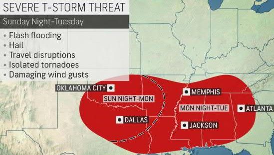
April 1, 2022
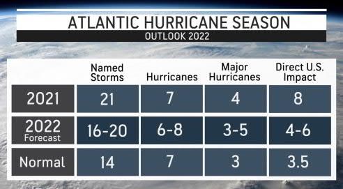
2022 Atlantic Hurricane Season Forecast Update
· The Atlantic hurricane season is two months
away, with the official start arriving on June
1, but AccuWeather forecasters
released predictions for the coming season
this week, noting that there is a high chance
for a preseason storm to develop and that
another active tropical season is expected.
· AccuWeather’s team of tropical weather
forecasters, led by veteran meteorologist
and hurricane expert Dan Kottlowski, is
once again predicting an above-normal
season in terms of tropical activity in the
Atlantic, as well as a higher-than-normal chance that a major hurricane could make landfall in
the mainland United States, Puerto Rico and the U.S Virgin Islands.
· Specifically, Kottlowski’s team is forecasting 16-20 named storms and six to eight hurricanes. Of
those hurricanes, about three to five are forecast to reach major hurricane status, which occurs
when a storm reaches Category 3 strength with winds exceeding 111 mph or higher.
· As of March 30, Kottlowski says a weak La Niña is in place, and it is expected to persist through
the beginning of the tropical season.
· Kottlowski noted that a shift to a neutral phase could occur during the summer but if La Niña
remains in place, or even intensifies, then it’s possible that there could be more than 20 storms,
he said.
· The status of La Niña throughout the summer will be closely monitored by meteorologists. If the
La Niña phase ends up fading away over the summer or early in the fall, the tropical activity
could wind down well before the official end of the season on Nov. 30.
· Tropical depressions or storms have gotten a jump start on the official June 1 start date in the
Atlantic for seven consecutive seasons, something that has caused the National Hurricane
Center (NHC) to consider moving the season’s start date to May 15.
· Kottlowski said that in addition to the presence of La Niña, above-normal sea-surface
temperatures in key tropical development regions will result in a higher-than-normal chance of
preseason development for the eighth year in a row.
· Sea-surface temperatures are above normal over much of the Gulf of Mexico and the Caribbean
and even off the East Coast of the United States, especially the southeast coast of the United
States, and these are critical areas for early season development.
· Waters are currently cooler in the eastern Atlantic and toward the coast of Africa, but
meteorologists expect that the waters will be sufficiently warm enough in that part of the basin
by the peak of the season in middle to late August.
3 The Daily DART is a publication of WSP USA Inc. All rights are reserved.
Any unauthorized use, disclosure, viewing, copying, alteration, dissemination or distribution without permission is strictly prohibited.
April 1, 2022

                                Joint Preliminary Damage Assessments
                                                                                               Number of Counties for IA
State                                         Event                                                                                           Start-End
                                                                                                Requested             Completed

                                      Severe Weather
 TX                                                                                                    10                     0               3/28-TBD
                                       March 21-TBD

                       Pending Individual Assistance Declaration Request
                                                                                      Date               Approved/Denied                 Number of
State                                    Event
                                                                                    Submitted               /Pending                   Counties/Tribes
                  Severe Storms, Straight-Line Winds &
 FL                            Tornadoes                                             2/24/2022           Pending (Appeal)                  2 Counties
                              Jan 16, 2022

                           WSP USA Inspection Services Active Disasters
Disaster Number                                                         Number of Counties                      Days Since                Registration
                                      Disaster Type
   and State                                                               Declared                              Launch                    Deadline

        4611 LA                         Hurricane                              25 Parishes                            213                   11/29/2021

        WSP USA INSPECTION SERVICES ACTIVITY
        1

        4   The Daily DART is a publication of WSP USA Inc. All rights are reserved.
            Any unauthorized use, disclosure, viewing, copying, alteration, dissemination or distribution without permission is strictly prohibited.
You can also read