(ECMWF) TIGGE, GIFS and SWFDP - David Richardson Head, Meteorological Operations Section
←
→
Page content transcription
If your browser does not render page correctly, please read the page content below
TIGGE, GIFS and SWFDP

                                  David Richardson
                Head, Meteorological Operations Section,
      European Centre for Medium-Range Weather Forecasts
                                          (ECMWF)
                          david.richardson@ecmwf.int
                                                    Slide 1

GEOSS African Water Cycle February 2011             Slide 1
The THORPEX Interactive
Grand Global Ensemble (TIGGE)

THORPEX: a World Weather Research Programme to accelerate the
improvements in the accuracy of 1-day to 2-week high-impact
weather forecasts for the benefit of humanity

A key component of THORPEX, the TIGGE project has
developed a database of global ensemble forecasts collected
                                    Slide 2
in near real-time.

GEOSS African Water Cycle February 2011   Slide 2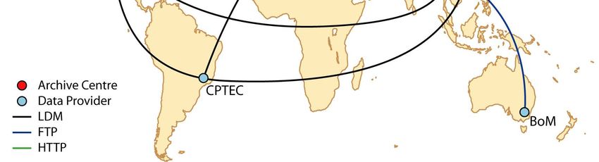
TIGGE
Objectives:
       Enhance collaboration on ensemble prediction, both
        internationally and between operational centres & universities.
       Facilitate research on ensemble prediction methods, especially
        methods to combine ensembles and to correct systematic errors
       Enable evolution towards a prototype operational system, the
        “Global Interactive Forecast System”

Since October 2006, the TIGGE archive has been accumulating
regular ensemble weather forecasts from leading global
Numerical Weather Prediction (NWP) centres.
TIGGE is weather contribution to GEOSS (GEO task WE-06-03)
For more about TIGGE and access to data archive see
http://tigge.ecmwf.int              Slide 3

GEOSS African Water Cycle February 2011      Slide 3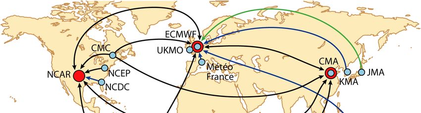
TIGGE data flows
(6 to 30h after real time)

                                          Slide 4

GEOSS African Water Cycle February 2011   Slide 4
                                                    4
TIGGE infrastructure
                                               Predictability
                                                                        Applications
  Data collected in                              science
   near-real time (via
   internet) at central                   academic               NHMS                  users
   TIGGE data archives

  Could be
   implemented at
   relatively little cost

  Can handle current                        NCAR                ECMWF             CMA
   data volumes
   (approaching 300
   GB/day) within
   available network and
                                                       Slide 5
   storage capabilities                       EPS 1               EPS 2                EPS n

GEOSS African Water Cycle February 2011                Slide 5
Summary of TIGGE database
Ensemble Output data Forecast Forecasts Fields
Centre Start date
members Resolution length per day (out of 73)
BOM 33 1.50º x 1.50º 10 day 2 55 3 Sep 07
CMA 15 0.56º x 0.56º 10 day 2 60 15 May 07
CMC 21 1.00º x 1.00º 16 day 2 56 3 Oct 07
CPTEC 15 1.00º x 1.00º 15 day 2 55 1 Feb 08
N200 (Reduced
ECMWF 51 Gaussian) N128 15 day 2 70 1 Oct 06
after day 10
JMA 51 1.25º x 1.25º 9 day 1 61 1 Oct 06
KMA 17 1.00º x 1.00º 10 day 2 46 28 Dec 07
Météo-France 11 1.50º x 1.50º 2.5 day 1 62 25 Oct 07
Slide 6
NCEP 21 1.00º x 1.00º 16 day 4 69 5 Mar 07
UKMO 24 1.25º x 0.83º 15 day 2 70 1 Oct 06
GEOSS African Water Cycle February 2011 Slide 6Comparing 9 TIGGE models & the MM
T-2m, DJF 2008/09
NH (20°N - 90°N)
BC vs. ERA-interim
Symbols used for
significance level
vs. MM (1%)
Slide 7
GEOSS African Water Cycle February 2011 Slide 7Some nice features of TIGGE that
demanded a lot of effort
All data are archived at native resolution (on native grid when
possible)
Data are interpolated on any limited-area lat-lon grid defined by
the user just before download
Field names, definitions, units, accumulation times, etc… are
fully standardized
Data gaps are continuously monitored and every effort is made
to repair them quickly
Data can be obtained either in GRIB2 or NETCDF format (only
from NCAR at the moment)
More functionalities will be installed (e.g. access to single
point data, automatic requests, local calculation and plot
Slide 8
generation, etc…) depending on user numbers, requests and
funding
GEOSS African Water Cycle February 2011 Slide 8Registered TIGGE users at ECMWF
687
Slide 9
GEOSS African Water Cycle February 2011 Slide 9Towards the Global Interactive Forecast
System (GIFS)
TIGGE provides the basis for the development of a future
Global Interactive Forecast System. GIFS aims to improve
the probabilistic early warnings of severe weather based on
TIGGE research and other strands of the THORPEX
programme.
As a first step, GIFS products are being developed to support
forecasts of tropical cyclones and heavy precipitation, to be
tested in regional Forecast Demonstration Projects.
This will be done in collaboration with the WMO Severe
Weather Forecast Demonstration Projects
Slide 10
GEOSS African Water Cycle February 2011 Slide 10WMO Severe weather Forecast Demonstration
Projects (SWFDP)
Overall aims of SWFDPs:
To improve the ability of National Meteorological and Hydrological
Services (NMHSs) to forecast severe weather events
To improve the lead time of warnings for these events
To improve interaction of NMHSs with disaster management and civil
protection authorities and media before and during events
To identify gaps and areas for improvements;
To improve the skill of products from global weather forecast providers
(GDPFS Centres) through feedback from NMHSs
Slide 11
GEOSS African Water Cycle February 2011 Slide 11WMO Severe weather Forecast Demonstrations
Projects (SWFDP)
The SWFDP utilizes the WMO-CBS cascading approach for
forecasting severe weather in three levels, as follows:
global NWP centres to provide available NWP products, including in
the form of probabilities;
regional centres to interpret information received from global NWP
centres, run limited-area models to refine products, liaise with the
participating NMHSs;
NMHSs to issue alerts, advisories, severe weather warnings; to liaise
with Disaster Management and Civil Protection Authorities (DMCPA)
and news media, and to contribute to the evaluation of the project.
The cascading process aims to ensure the real-time distribution of
the relevant available information produced by both a Global
Centre(s) and a Regional Centre(s) to selected
Slide 12 NMHSs.
GEOSS African Water Cycle February 2011 Slide 12WMO Severe weather Forecast Demonstrations
Projects (SWFDP)
First SWFDP was for southern Africa
Second SWFDP running for SW Pacific
New SWFDP now being set up for E Africa
Slide 13
GEOSS African Water Cycle February 2011 Slide 13ECMWF support to SWFDP
ECMWF provides a specific set of products for each SWFDP on
special pages on the ECMWF website (login and password needed)
The Extreme Forecast Index for
Probability of precipitation of 10 precipitation calculated for the ten-
mm/24h or more during Monday 12 day period 8-18 October 2009.
October according to the forecast Areas that might experience
from DT 00UTC Friday 9 October. abnormally high precipitation
Heavy rain expected in equatorial W amounts during this period are
Africa parts of south and equatorial
Africa.
Slide 14
GEOSS African Water Cycle February 2011 Slide 14TIGGE/GIFS Support to WMO SWFDP
Objectives:
To develop and test prototypes for forecasting various high impact
events.
To evaluate the prototype products in an operational environment
for a limited time period (1-2 years+)
To transition successful products into ongoing operations
Collaboration with the WMO SWFDP
Focus on regional subprojects: Southern Africa, E Africa, SW
Pacific; possible future projects in Asia, S. America
Use regional cascade infrastructure set up for SWFDP
GIFS-FDP products will supplement products distributed by
Slide 15
SWFDP, once regional SWFDP subproject is well-established
Training on the use of these products
GEOSS African Water Cycle February 2011 Slide 15Enhancements to SWFDP
Compared with the products available currently in the existing
SWFDP programme, GIFS-FDP will add:
Scientifically driven development of new types of products to
highlight forecasts of severe weather;
Products based on multi-model ensembles;
Statistically bias corrected and downscaled information;
Longer range outlooks including week-2 forecasts for planning
and mitigation efforts related to possible future high-impact
weather events.
While SWFDP includes subjective assessments by forecasters,
GIFS-FDP will also entail objective verification by regional &
Slide 16
national centres.
GEOSS African Water Cycle February 2011 Slide 16Tropical cyclone tracks
In response to IWTC, the GIFS-TIGGE working group initiated the
exchange of real-time tropical cyclone track predictions using “Cyclone
XML” format
Data made available in real-time for beginning in summer 2008 for the T-
PARC project from most TIGGE partners
Further developments include:
Extension to wind speed, intensity, etc.
Development of tools to visualise data
Slide 17
GEOSS African Water Cycle February 2011 Slide 17Heavy Rainfall
Precipitation is the next high priority focus for GIFS
development
Heavy rainfall (and associated flooding) is one of the main
concerns for the SWFDPs in Africa
More challenging logistics than tropical cyclone problem
Data volume – real-time exchange much more challenging
Need for data sets for calibration & verification
Early results:
Promising early results for prediction of Mei-Yu, S. China Sea
Monsoon and post typhoon heavy rainfall
Slide 18
Other work has focused on heavy rainfall and river flow in SE
Europe with promising results
GEOSS African Water Cycle February 2011 Slide 18Summary
Since October 2006, the TIGGE archive has been accumulating
regular ensemble forecasts from leading global NWP centres.
TIGGE is weather contribution to GEOSS (GEO task WE-06-03)
The archive is a tremendous resource for the research
community at large, and in particular the science working groups
of THORPEX.
TIGGE provides the basis for research and development projects
targeted at specific applications of severe weather forecasts
(health, energy, flood warning, wind storms, fire weather, etc…).
TIGGE support in Africa through WMO SWFDP (S, E Africa),
THORPEX Africa; emphasis on developing products for early
warnings of heavy rainfall
Slide 19
TIGGE website: http://tigge.ecmwf.int
GEOSS African Water Cycle February 2011 Slide 19You can also read