"AZERBAIJAN POSITIONING OBSERVATION SYSTEM (AZPOS) FOR REAL ESTATE CADASTRE DATA BASE" - Chingiz Tanirverdiyev - Real estate cadastre department ...
←
→
Page content transcription
If your browser does not render page correctly, please read the page content below
“AZERBAIJAN POSITIONING OBSERVATION SYSTEM
(AZPOS) FOR REAL ESTATE CADASTRE DATA BASE”

  Chingiz Tanirverdiyev –   Real estate cadastre department of Real
                           Estate Cadastre and Technical Inventory Centre
                 e-mail : chtanriverdiyev@emdk.gov.az,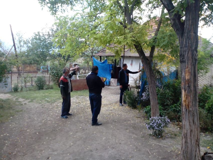
REAL
  ESTATE
  REGISTRATION
  PROJECT


Component
  C:
  Base
  Mapping
  and
  Land
  Cadastre


Subcomponents:


  C.1
  Establishing
  37
  Con;nuously
  Opera;ng
  Reference
  Sta;ons
  /CORS;


  C.2
  Produc;on
  of
  orthophotomaps
  through
  satellite
  and
  aerial
  imagery;


  C.
  3
  Development
  of
  land
  parcel
  maps;


  C.
  4
  Improving
  the
  sustainability
  of
  the
  services.


 Component
  A2/B1
  :

 Development
  of
  Real
  Estate
  Registra;on,
  Cadastre
  and
  Management

 System.
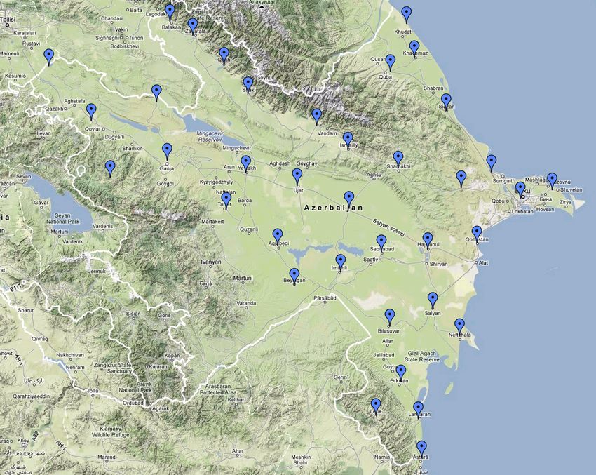
AZPOS (CORS) Network Azerbaijan System Overview
AZPOS (CORS) Network Azerbaijan System Overview
§ Network design
§ Good spacing
§ Similar altitudes
§ Good observation
conditions
70km
70km
AZPOS-Network Design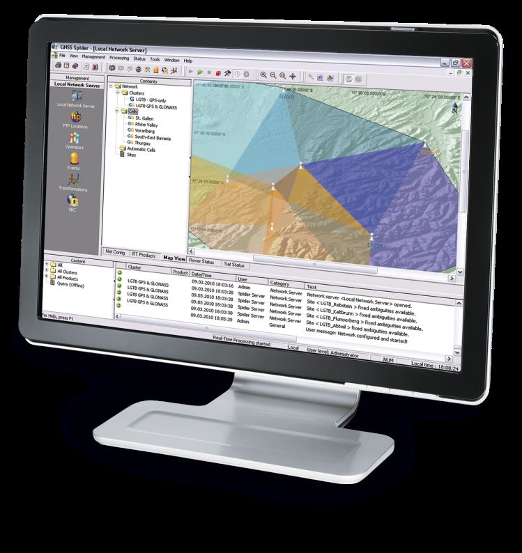
AZPOS (CORS) Network Azerbaijan System Overview

 AZPOS will provide the following benefits:

• Access to comprehensive geospatial reference systems;

•High productivity and operation availability in common system;

• Real-time 3D positioning, RTK in cm level and DGNSS in meter level
operations;

  All surveying works in the Republic will be carried out in the same
system and format. Map and cadastral works, engineer surveying,
underground communication works, planning works etc. will be
carried out rapidly and with reduced costs by means of the system.
AZPOS (CORS) Network Azerbaijan System Overview AZPOS provide different GNSS Surveying Methods: •Post-Processing; •RTK (Real Time Kinematics); • DGNSS (Differential Global Navigation Satellite System). The following aspects have been considered while construction of antenna ground points and installation of communication network for AZPOS development: Øproviding the protection of antennas; Øproviding the sustainability of selected locations; Øno limitations in internet access of antenna; Øeliminating thunder risks; Ø non-existence of underground communications; Ømaintenance of construction works, installation of antenna; ØWGS-84 coordination system has been considered reasonable in UTM38,39 projection

AZPOS (CORS) Network
                                 Azerbaijan System Overview

The Management Centre has been provided with software
which controls the activities of the stations, as well as able to
maintain data management, data corrected in real time
adjustments and calculations.
The Control Centre is monitoring the data received from 37
reference stations in the Republic territory and provides 100
parallel users with RTK services, meantime 25 parallel users
with Web services.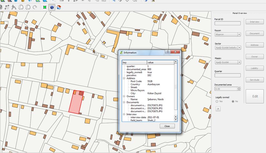
AZPOS (CORS) Network Azerbaijan System Overview
Support for Multiple Applications
§ National Mapping Producers
§ Cadastre
§ GIS
§ Utility Companies
§ Telecoms
§ Transport Departments
(fleet management…)
§ Infrastructure & Road construction
§ Natural Resource Management
(Mining, Exploration)
§ Scientific (atmospheric modelling, seismic monitoring,…)
§ Meteorological Agency,
Weather forecasts
§ Environmental Agencies
§ Agriculture
§ Natural Hazards & Disaster Management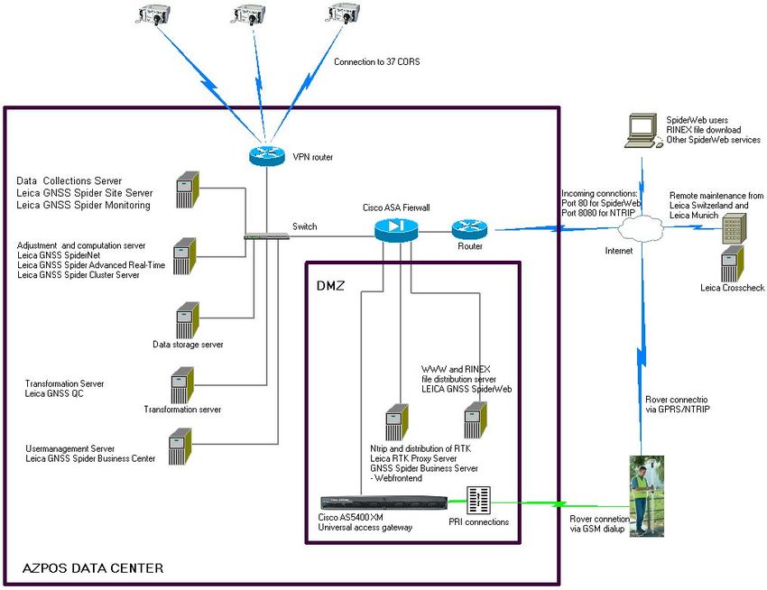
AZPOS (CORS) Network Azerbaijan System Overview
What does CORS Network consist of?
CORS Network AZPOS consists of four
segments:
§ Spatial Segment:
§ GPS, Glonass, Galileo, Compas
§ Ground Segment
§ GNSS antennas and receivers
§ Control Center
§ User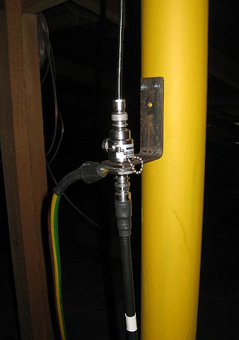
AZPOS (CORS) Network Azerbaijan System Overview How does it work? Setting up a CORS Mast § Antenna § Cables § Lightning protection § Antenna mount § Monumentation § Underground § Station environment
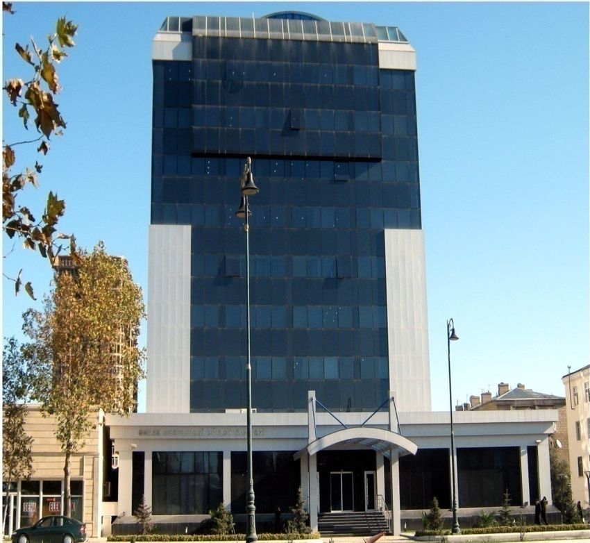
AZPOS CORS Network
                      AZPOS DATA CENTER
CORS Control Center
AZPOS Network
Types of Services
• Real-Time
• Post-processingAZPOS Network
Post-processing Services
Online Coordinate Computation Service
§ No RINEX download needed
§ No office software needed
X XAZPOS Network
Post-processing Services
Online Coordinate Computation Service
§ upload field data to webportal
§ online computation made by SpiderWeb
X,Y,ZAZPOS Network
Real-Time Services
Single base RTK – Classical Approach Problems
§ base becomes unlevelled
§ loose power on radio or receiver
§ base gets stolen
X,Y,ZAZPOS Network
Real-Time Services
CORS Single base RTK
Internet
X,Y,Z
X,Y,Z
CORS Networks Communications
§ ADSL VPN network
§ GPRSAZPOS Network
Real-Time Services
Benefits
ü Savings in
ü Hardware
X
X,Y,Z
ü Time
ü Man power
$ X,Y,Z
X,Y,Z
A
A
ü Positioning Quality
ü Reliable M
A
ü Consistent A
ü Accurate
X,Y,ZAZPOS Network Benefits
§ Increased coverage
§ Improved availability
B
§ Improved reliability
E
N § Faster rover initialisations
E § Consistent high accuracy
F
§ Higher productivity
I
T § No local base station required
S § Fewer reference stations needed
§ Working on a common datumLAND
STRUCTURE
IN
THE
REPUBLIC
OF
AZERBAIJAN
There
are
3
types
of
proper;es
in
the
Republic
of
Azerbaijan
:
State,
Municipal,
Private.
• 57
%
of
land
belongs
to
the
state.
• 23%
of
land
belongs
to
the
municipali;es.
• 20%
of
land
belongs
to
the
private
ownership.
UNIFIED
  STATE
  CADASTRE
  OF
  REAL
  ESTATE

    CADASTRE
  OF

 NATURAL
  RESOURCES

                                                                                                                                                                                              CADASTRE
  OF
  OIL

                                                                                                                                                                                                                        AND
  GAS
  DEPOSITS


                                  FOREST
  CADASTRE

                                                                              WATER
  CADASTRE
                                   URBAN
  PLANNING
                         LAND
  CADASTRE


                                                                                                                                       CADASTRE


                                                                                            CONTENT OF CADASTRES

                                        •Division of forests                                                                     • evaluation of area
                                        on valuation grades;                                                                     according to urban                                  • qualitative
•Data on
                                        • state register of                       • Quantitative                                 planning criterion,                                 evaluation of
natural                                 forest fund;                              and qualitative                                monitoring of urban                                 land fertility
resource                                • Division of forests                                                                    planning activity objects;
                                                                                  inventory of                                                                                       •Economical                                 •Data on oil
deposits                                according to the                                                                         • definition of norms and
                                                                                  water;                                                                                             evaluation of                               and gas
(metal and                              species and age                                                                          rules in the field of urban
                                                                                                                                                                                     lands                                       deposits
non-metallic);                          groups;                                   • Inventory and                                planning;
•Data on hard                           • Division of forest                      register of water                              • Compilation of acts on
rock deposits                           fund according to                         use                                            permission for the
                                        the administrative-                                                                      constructions, acceptance
                                        territorial units                                                                        and use of construction
                                                                                                                                 objects ;

                                                                                     BODIES,
  DEVELOPING
  AND
  MAINTAINING
  REGIONAL
  CADASTRE`


                                                Ministry
  of
  Ecology
              1.
  Ministry
  of
  Ecology
  and
  Natural

        Ministry
  of
  Ecology
                                                         Resources
  of
  the
  Republic
  of
           State
  CommiSee
  on
                State
  Land
                        State
  Oil
  Company
  of

                                                   and
  Natural
                                                                              Urban
  Planning
  and
              Cartography

           and
  Natural
                                                                               Azerbaijan
                                                                                                              the
  Republic
  of

                                                 Resources
  of
  the
                 2.
  Open
  Joint
  Stock
  Company
  of
            Architecture
                    CommiSee
  of
  the

         Resources
  of
  the
              Republic
  of
  Azerbaijan
                                                                                                                                                          Azerbaijan

           Republic
  of
                                                               Meliora;on
  and
  water
  industry
  of
                                             Republic
  of
  Azerbaijan

                                                                                                the
  Republic
  of
  Azerbaijan
            Azerbaijan


                                                                                           STATE
  COMMITTEE
  ON
  PROPERTY
  ISSUES

                                             Body,
  that
  the
  data
  on
  development
  and
  maintenance
  of
  unified
  state
  cadastre
  of
  real
  estate
  are
  collected


                                                                                     UNIFIED
  STATE
  CADASTRE
  OF
  REAL
  ESTATE
UNIFIED
STATE
CADASTRE
OF
REAL
ESTATE
Unified state cadastre of real estate is implemented by Real Estate
Cadastre and Technical Inventory Center (RECTIC) of SCPI.
ACTIVITY DIRECTIONS
• Development
of
digital
cadastre
database
on
all
types
of
real
estates
not
depending
on
its
property
type
and
assignment;
• Development
of
digital
cadastre
maps;
• Implementa;on
of
mass
inventory
of
real
estate;
• Preparing
of
zone-‐value
maps
for
the
purposes
of
mass
evalua;on
of
real
estate;
• Cadastre
evalua;on
of
real
estate;
• Cadastre
services
for
ci;zens
and
business
organiza;ons,
preparing
cadastre
plans
and
giving
informa;on.
NOTE:
Address
register
system
is
implemented
by
RECTIC
of
SCPI.
CADASTRAL DATA COLLECTION MECHANISM

                                           data

                                         collec;on


                         surveying


                                                         limita;on


                                                                         22
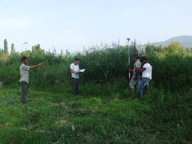
Activities and Aims for the Cadastre Project
Ø Capturing of ownership and boundary-
data „on-site“
Ø Complete area systematic surveying
Ø Simplification of registration process
Ø Data base for legal registration of
ownership and
for municipal and state land managementActivities and Aims for the Cadastre Project (cont.) Ø Involvement of property owners in pilot areas Ø Public awareness and information campaign Ø Baseline survey with ex-ante and ex-post interviews Ø Public presentation of surveying results Ø Employment of local professionals for surveying and baseline survey
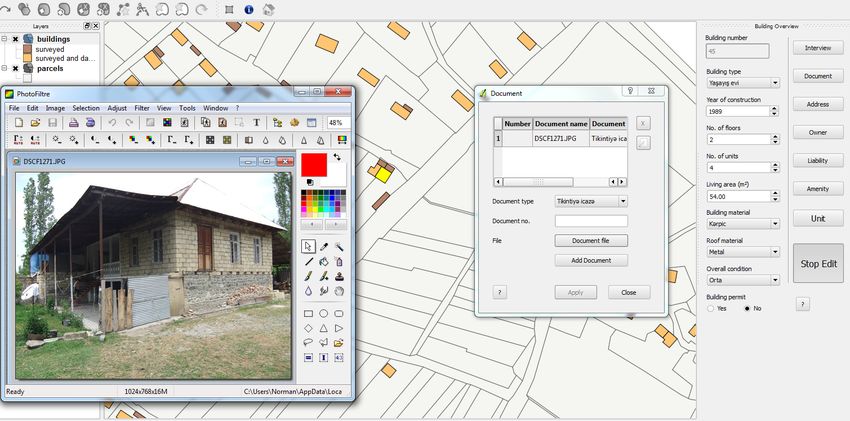
DESCRIPTION
  OF
  REAL
  ESTATES
  IN
  CADASTRE
  DATABASE
  AND

                              DIGITAL
  MAP
  (FRAGMENT)


25
Conclusions and recomenda;ons § At the moment AzPos is used to conduct geodetic surveying, cadastral works and GIS applications; §AzPos provide real time horizontal coordinate determination with accuracy 2 cm in horizontal and 4 cm in vertical position. Baltic sea height determination with accuracy 5-10 cm is possible using EGM2008 geoids model; §To increase accuracy up to 2 cm regional cooperation is necessary to integrate GNSS data of neighbouring countries and to develop quasigeoid model at the national level ; §In the future AzPos could be used for scientific applications special for geodynamic investigations taking in account the risk of earthquakes.
Real
  Estate
  Cadastre
  and
  Technical
  Inventory

Centre:


  address:
  Baku
  city,

  Yasamal
  region,
  31

  H.
  Javid
  avenue


  email:
  www.emdk.gov.az


  telephone:


  +994
  12
  5108430


  THANK
  YOU
  FOR
  YOUR

      ATTENTION!
You can also read