Sistemi di Guida e Navigazione (6CFU - 60 ore) - Laurea Magistrale in Ingegneria Robotica e dell'Automazione Anno Accademico 2018-2019
←
→
Page content transcription
If your browser does not render page correctly, please read the page content below
Sistemi di Guida e Navigazione
                       (6CFU – 60 ore)

      Laurea Magistrale in Ingegneria Robotica e dell’Automazione

                     Anno Accademico 2018-2019

28/02/2019                Docente: Lorenzo Pollini                  1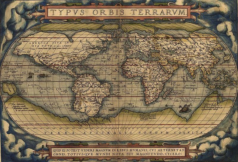
Lunedi’ ore 15:30-18:30

             Mercoledì ore 13:30-15:30

                  Ricevimento
             Mercoledi’ 14:30-16:30

28/02/2019        Docente: Lorenzo Pollini   2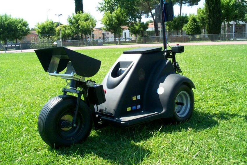
Programma del Corso
• Presentazione del corso e contesto generale dei problemi di guida
  e navigazione nella problematica di controllo. (2 ore)
     • Cosa si intende per navigazione
     • Cosa si intende per guida
     • Tipologie di veicoli di interesse (terrestri, marini, aerei). Cenni storici
       con esempi di componenti.

28/02/2019                     Docente: Lorenzo Pollini                          3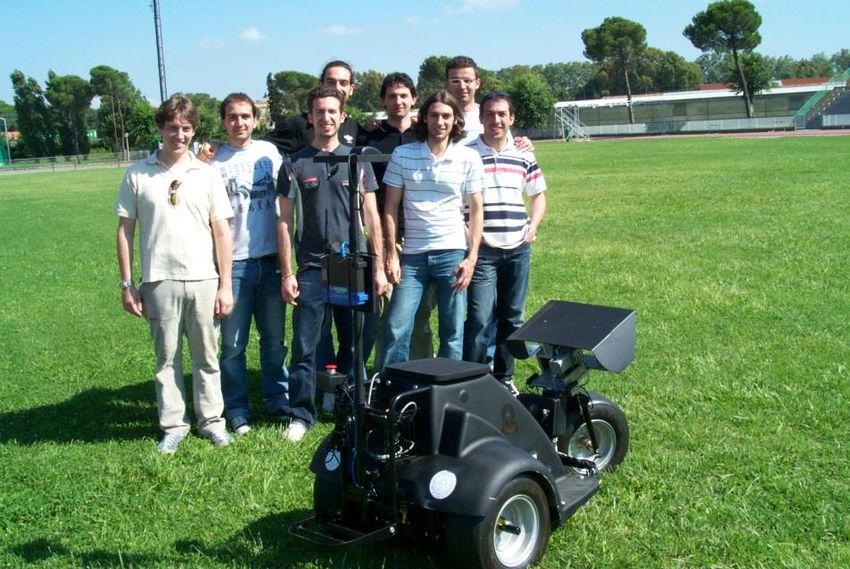
Programma del Corso

• Sistemi di Navigazione (25-30 ore)
     • Definizione del problema di navigazione. Navigazione inerziale,
       piattaforma stabilizzata e strap-down.
     • Componenti del sistema di navigazione: giroscopi, accelerometri e loro
       modellazione.
     • Sistemi di riferimento, wander frame, moto relativo, modello terrestre
       e di gravità, variabile tempo, inizializzazione.
     • Equazione di navigazione, errori di navigazione e loro origine. Esempio
       2D.
     • Derivazione delle equazioni di navigazione 3D.
     • GPS, navigazione satellitare, errori del GPS. Uso del filtro di Kalman
       per la Navigazione integrata INS/GPS. Esempi numerici e
       sperimentali.

28/02/2019                   Docente: Lorenzo Pollini                       4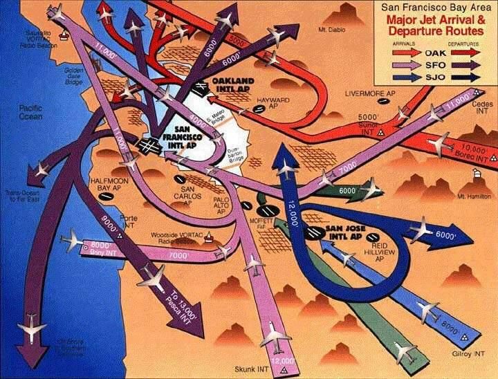
Programma del Corso

• Sistemi di Guida (25-30 ore)
     • Problema della guida intesa come anello chiuso.
     • Relazione con gli anelli interni (stabilità, autopilota) e carattere
       cinematico del problema.
     • Navigazione proporzionale (PN): problema analitico generale.
     • Altre tipologie di guida: guida beam rider, command guidance, guida
       basata su tecniche fuzzy. Esempi applicativi numerici.

• Seminari e/o esempi applicativi su sistemi Autonomi (2-5 ore)
     • Problema della guida e navigazione di sistemi mobili cooperanti.
       Velivoli autonomi, guida in presenza di ostacoli fissi e mobili.

28/02/2019                   Docente: Lorenzo Pollini                         5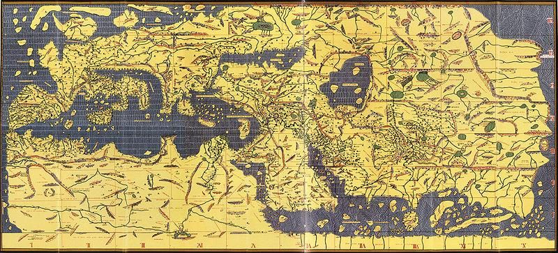
Esercitazione Pratica
• Esercitazione fino a 2011:
     • Implementazione e test sul campo di:
             • Leggi di navigazione
             • Leggi di guida
     • Piattaforma:
             • ULISSE UGV
             • Disponibile simulatore completo in Simulink
             • Possibilità di simulazione Hardware In the Loop

                                                                 2008
28/02/2019                            Docente: Lorenzo Pollini          6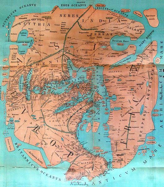
Esercitazione Pratica

             2009                                 2010

28/02/2019      Docente: Lorenzo Pollini
                                           2011     7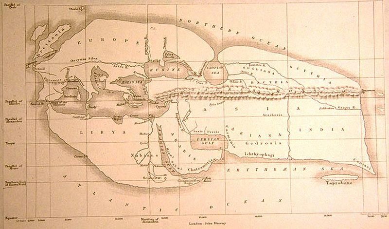
Esercitazione post 2011
• Linee generali:
     • Implementazione e test sul campo di:
             • Algoritmi di navigazione inerziale integrata
     • Piattaforma:
             • Sistema low cost di prototipazione rapida TI e/o ST
             • Sensori inerziali e GPS low cost
             • Sviluppo software linguaggio C/Embedded Matlab Functions e Simulink

28/02/2019                          Docente: Lorenzo Pollini                         8
Testi e Riferimenti
• Navigation
     • Rogers Robert, Applied Mathematics in Integrated Navigation
       Systems, AIAA Education Series, 2000.
     • Titterton and Weston, Strapdown Inertial Navigation Technology, Peter
       Peregrinus Ltd, 1997.
• Guidance
     • Zarchan Paul, Tactical and Strategic Missile Guidance, AIAA Progress
       in Aeronautics and Astronautics, Vol. 199, 2002.
     • Fossen Thor, Guidance and Control of Ocean Vehicles, John Wiley &
       Sons, 1995.
     • Fossen Thor, Marine Control Systems, Marine Cybernetics 2003.
• Various (additional material provided by the teacher)
     • Journal Publications
     • Excerpts from other books

28/02/2019                   Docente: Lorenzo Pollini                         9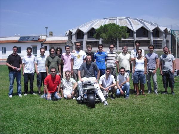
Basic Definitions

• Guidance and navigation concepts are as old as human travel, and
  deal with the general questions of:

     •   where we are
     •   where we are going
     •   how we go from one point to another
     •   How precisely have we reached our objective

• The methods used find their origin in motion and moving vehicles,
  but then they can be applied to a variety of systems, whose
  components need a precise location in the space-time domain.

     • Location and distribution of goods
     • Motion of packets in a network

28/02/2019                   Docente: Lorenzo Pollini            10
Basic Definitions
Guidance
• is the action or the system that
continuously computes the reference
(desired) position, velocity and
acceleration of a vehicle to be used by
the control system. These data are
usually provided to the human operator
and the navigation system.
• The guidance system may be implemented
in an open loop or closed loop form, it
possibly interacts with the control
system.
28/02/2019 Docente: Lorenzo Pollini 11Basic Definitions
Navigation
• The navigation problem answers two
fundamental questions of motion and
travel:
• what is my current position?
• where am I travelling to?
• It is primarily an open loop process,
and obviously connected to the
guidance loop.
• A fundamental role is the
determination and reduction of all
possible errors concurring to the
evaluation of the current position,
which then will give input to the
guidance system.
• It must be noted that such problem
requires the definition of several
reference systems that need to be
used to relate the motion.
28/02/2019 Docente: Lorenzo Pollini 12Framework
• Guidance and Navigation are part
of the general motion process of
a vehicle, which includes:
• Stability, transient Performance
• Steady state Error
• Disturbance Rejection
• Kinematic Tracking
• Mission Success
28/02/2019 Docente: Lorenzo Pollini 13Framework 28/02/2019 Docente: Lorenzo Pollini 14
Background-Guidance
• Early guidance methods were studied in Germany during the end
  of WWII, when the objective was to achieve successful impact of
  V-2 rockets on British soil.
     • Inertial guidance:
             • 2 gyroscopes for attitude stabilization
             • 1 integrating accelerometer to estimate
               velocity for initiation of ballistic flight
               (altitude about 80 km)

28/02/2019                           Docente: Lorenzo Pollini   15
Background-Guidance
• One of the most challenging applications,
that led to advances in guidance,
was the Apollo program, where precision
path following was linked to the survival
of the astronauts.
Re-entry window A- Friction with air, B- In air flight. C- Expulsion lower angle, D- Perpendicular to the entry point,
E- Excess friction 6.9° to 90°, F- Repulsion of 5.5° or less, G- Explosion friction, H- plane tangential to the entry point
28/02/2019 Docente: Lorenzo Pollini 16Background-Guidance
• Guidance is a key technology in missile defence (and also attack)
against moving targets
Intercept
a = −NV
28/02/2019 Docente: Lorenzo Pollini 17Background-Guidance • Guidance is a closed-loop process 28/02/2019 Docente: Lorenzo Pollini 18
Background-Navigation
• The art of finding the way from one place to another is called
  navigation. Until the 20th century, the term referred mainly to
  guiding ships across the seas. Today, the word also encompasses
  the guidance of travel on land, in the air, and in inner and outer
  space.
• The navigation of rivers, lakes and oceans began before recorded
  history. Navigation, due to its relationship and importance to
  transportation, has played a leading part in the advancement of
  civilization.

28/02/2019               Docente: Lorenzo Pollini                 19
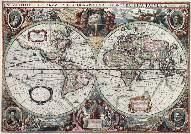
Navigation for mapping

28/02/2019        Docente: Lorenzo Pollini   20
Background-Navigation
•   One great aid to navigation was the development of the magnetic
    compass. Although men had known of the magnetic properties of the
    lodestone for centuries before the Christian Era, the first use of the
    magnetic compass by navigators appears to have been in the 12th
    century.
•   Navigators at this time also used the cross-staff and the astrolabe, two
    devices that the Greeks had invented to measure the altitudes of celestial
    bodies. From these measurements it was possible to determine the
    approximate latitude of the vessel as well as approximate local time.
•   In 1731 John Hadley, an Englishman, and Thomas Godfrey, an American,
    simultaneously invented a quadrant that made it possible to obtain
    accurate observations of celestial bodies. The instrument was similar to
    the sextant in common use today. The problem of fixing longitude was
    solved, when John Harrison in England produced several chronometers
    between 1730 and 1763.

28/02/2019                    Docente: Lorenzo Pollini                      21
Background-Navigation
• Dead Reckoning
• In dead reckoning, the navigator estimates a ship's position by keeping a careful
record of its movement. The initial point of departure for dead reckoning is
usually the last fix the navigator obtains from objects on land at the start of a
voyage. From this point, true courses steered and distances traveled (as
recorded by log) are plotted on a chart.
• Electronic Navigation
• Modern electronic devices are important aids in finding position at sea. For
example, the navigator whose ship is equipped with a radio direction finder can
determine the bearings of radio transmitting stations on shore. Special radio
beacons for navigation are established at lighthouses, lightships, and prominent
points along coasts. Radio bearings may be plotted on a chart to obtain a fix.
• GPS
• The Navstar Global Positioning System was implemented in the 1980s. This
system allows spacecraft crews to store their course in a computer system,
which can then verify the location of the spacecraft to within a few feet and the
speed of the spacecraft to within a few feet per second. The human navigator is
becoming more and more a manager of computer systems; however there is no
substitute for human judgment to deal with the occasional unexpected situation.
28/02/2019 Docente: Lorenzo Pollini 22Background-Navigation
• Inertial Navigation
• To a significant extent, inertial
navigation is about coordinate
frames. Inertial sensors measure
rate information relative to an
inertial frame of reference. An
inertial coordinate frame does not
rotate or accelerate with respect
to any other system of reference.
• Accelerometers measure change
of velocity with respect to an
inertial frame.
• Gyroscopes measure change of
rotation with respect to inertial
space.
28/02/2019 Docente: Lorenzo Pollini 23Background-Navigation
• Inertial systems (accelerometers,
gyroscopes, and computer) constitute
a self-contained unit, with no relation
with the outside world. There are two
implementations of the basic same
principle:
• Stabilized platform
• Strap down platform
• The stabilized platform isolates the
accelerometers from rotational
motions of the vehicle and maintains
the proper orientation of
accelerometer axes.
• Strap down platforms are
characterized by components rigidly
attached to the vehicle with benefits
due to reduced size, cost and
performance.
28/02/2019 Docente: Lorenzo Pollini 24Background-Navigation 28/02/2019 Docente: Lorenzo Pollini 25
Background-Sensors
• Linear accelerometers
     • They are used to measure the
       components of aircraft linear
       acceleration minus the
       components of gravity in its
       sensitive direction.

28/02/2019                  Docente: Lorenzo Pollini   26
Background-Sensors
• Gyroscopes
• The gyroscope was invented in
1852 by Leon Foucault (1819-
1868) as part of a two-pronged
investigation of the rotation of the
earth. The better-known
demonstration of the Foucault
pendulum showed that the plane
of rotation of a freely-swinging
pendulum rotated with a period
that depends on the latitude of its
location.
• At high speeds, the gyroscope
exhibits extraordinary stability of
balance and maintains the
direction of the high speed
rotation axis of its central rotor.
• If a gyro is tipped, the gimbals
will try to reorient to keep the
spin axis of the rotor in the same
direction.
28/02/2019 Docente: Lorenzo Pollini 27Background-Cooperative GNC
• An important and current research aspect involving all vehicles’
types
• Guidance issues with multiple agents
• Precision targeting (fixed, moving, etc.)
• Navigation issues in the presence of obstacles (fixed, moving, sudden,
etc.)
• Communications coordination
• Distributed versus Centralized Control
• Safety Issues (air traffic control, navigation in shallow waters, travel
around hazardous areas, etc.)
28/02/2019 Docente: Lorenzo Pollini 28Background-Cooperative GNC
• Navigation issues in the presence of obstacles (fixed, moving, sudden,
etc.)
28/02/2019 Docente: Lorenzo Pollini 29Background-Cooperative GNC
• Navigation issues in the presence of obstacles (fixed, moving, sudden,
etc.)
28/02/2019 Docente: Lorenzo Pollini 30Background-Cooperative GNC
• Navigation issues in the presence of obstacles (fixed, moving, sudden,
etc.)
28/02/2019 Docente: Lorenzo Pollini 31Background-Cooperative GNC
• Safety Issues (air traffic control, navigation in shallow waters, travel
around hazardous areas, etc.)
28/02/2019 Docente: Lorenzo Pollini 32DSEA Vehicles 28/02/2019 Docente: Lorenzo Pollini 33
You can also read