Some aspects of the navigation period extension in the North-West Basin of inland waterways of the Russian Federation
←
→
Page content transcription
If your browser does not render page correctly, please read the page content below
E3S Web of Conferences 258, 02004 (2021)                                  https://doi.org/10.1051/e3sconf/202125802004
UESF-2021

         Some aspects of the navigation period
         extension in the North-West Basin of inland
         waterways of the Russian Federation
         Vladimir Karetnikov1,*, Vyacheslav Bekriashev2, Gleb Chistiakov2, and Sergey Rudiyh2
         1Admiral Makarov State University of Maritime and Inland Shipping, Dvinskaya Street, 5/7, Saint-
         Petersburg, 198035, Russia
         2Volgo-Balt State Basin Administration, Bol'shaya Morskaya Street, 37, 190000, Saint Petersburg,

         Russia

                       Abstract. The Russian Federation has a developed system of inland
                       waterways (IWW) [1]. This system consists of 15 basins. Winter
                       conditions are very harsh in some basins. Such basins, for example, include
                       the Lena Basin. But in some basins, even in winter, conditions that block
                       navigation do not form. These basins include the Volga-Baltic. However,
                       during the extension of the navigation period in such basins, it should be
                       borne in mind that the navigation safety system will have to be upgraded.
                       This paper discusses some aspects, the introduction of which forms the
                       prerequisites for extension of the navigation period on the waterways of
                       the North-Western region of the Russian Federation. In addition, specific
                       recommendations are provided for the implementation of the necessary
                       automated systems to ensure a sufficient level of navigation in winter
                       conditions on the IWW. These recommendations were obtained within the
                       framework of the international project INFUTURE.

         1 Introduction
             The IWW of the Russian Federation is one of the key systems of the country’s transport
         complex. Having a number of significant advantages, they have the main drawback-the
         seasonality of their use. In the European part [2] of the country, the navigation period
         usually lasts from May to November. This is due to the beginning of ice phenomena and, as
         a result, the end of the navigation period.
             The IWW of the North-West basin provides two main transport functions (fig. 1):
             - connection of the Baltic ports [3] with the central regions of the European part of the
         Russian Federation;
             - cargo turnover within the North-West region [4].

         *
             Corresponding author: karetnikovvv@gumrf.ru

   © The Authors, published by EDP Sciences. This is an open access article distributed under the terms of the Creative
   Commons Attribution License 4.0 (http://creativecommons.org/licenses/by/4.0/).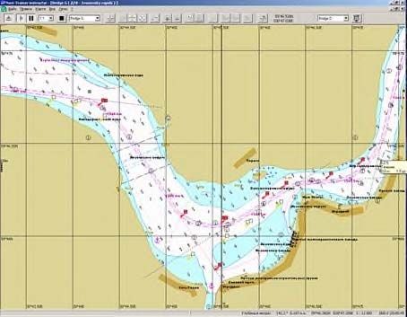
E3S Web of Conferences 258, 02004 (2021) https://doi.org/10.1051/e3sconf/202125802004
UESF-2021
Fig. 1. Main transport functions of the Northwest waterways.
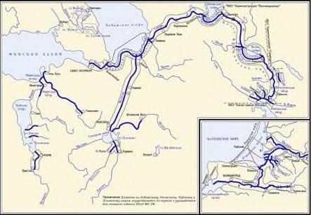
One of the main waterways in the North-West is the Volga-Baltic Waterway (VBWW)
[5], which includes the Neva River, Lake Ladoga (its southern route), the Svir River and
the Volga-Baltic Canal (fig. 2).
Fig. 2. Structure of waterways of the North-Western Basin of the Russian Federation.
Based on long-term hydrometeorological observations, it was established that due to
geographical and climatic features, the ice cover is primarily formed on the Volga-Baltic
Canal and the Svir River. Thus, connection with the central regions of the European part of
the Russian Federation by water is interrupted. But the Neva River and Lake Ladoga are
located closer to the Baltic Sea, in a region with a predominant temperate climate, so the ice
cover there is formed later, which allows for extension of navigation in these water areas.
Thus, despite the break with the waterways of the central part of the country, the
transport function continues to be carried out to ensure cargo turnover within the North-
Western region with the help of inland water transport. Specialists of the “Admiral
Makarov State University of Maritime and Inland Shipping” within the frame-work of the
INFUTURE project, implemented jointly with the Finnish party, considered the specifics of
ensuring the safety of navigation during the extension of navigation period and prepared
appropriate recommendations.
2 Methods and materials
We will consider the main features of navigation during the period of its extension. The
main factors affecting the level of safety of navigation during the extension of the
navigation period are the following:
2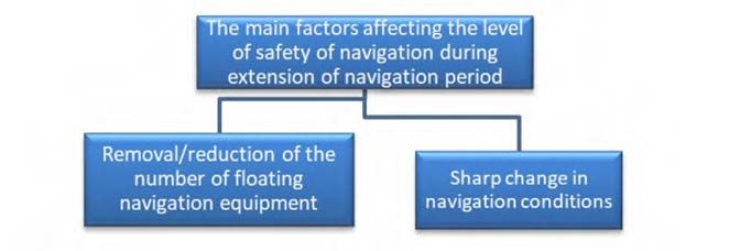
E3S Web of Conferences 258, 02004 (2021)                                https://doi.org/10.1051/e3sconf/202125802004
UESF-2021

            - removal/reduction of the number of floating navigation equipment;
            - sharp change in navigation conditions.

         Fig. 3. Main transport functions of the Northwest waterways.
             We will analyze each of the factors separately.
             After the end of the navigation period, the basins administrations usually remove all
         floating navigation signs. Only coastal navigation signs remain in their regular places, but
         without navigation lights. Thus, when navigating in such navigational conditions, skippers
         may have significant difficulties, which will undoubtedly affect the level of safety of
         navigation.
             Specialists of the “Admiral Makarov State University of Maritime and Inland Shipping”
         conducted a simulation of the safe traffic of the vessel [6] only using radar station (radar)
         [7] and electronic navigation map and information display systems (ECDIS) [8] in areas
         that are difficult for navigation in the conditions of extension of navigation period in the
         Neva River water area, using the NT Pro navigation simulator.
             To evaluate possible solutions that allow ensuring the necessary level of navigation
         safety of vessels’ traffic, the method of mathematical simulation was used using a modern
         navigation simulator, Navi-Trainer 4000 [9], developed by Transas company and installed
         at the Department of “Navigation on Inland Waterways”.

         Fig. 4. General view of the navigation bridge of the Transas NTPro 4000 simulator complex.
             The development of exercises is a step-by-step process that allows eliminating random
         errors during the direct implementation of the simulation and includes the following main
         stages:
             - navigation and hydrographic study of the simulation area;
             - selection of the settlement vessel;
             - exercise planning;
             - pre-playback of created exercises;
             - carrying out the exercises.

                                                          3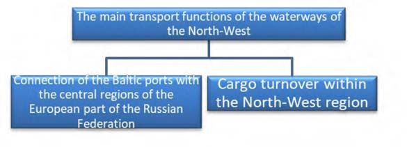
E3S Web of Conferences 258, 02004 (2021)                                  https://doi.org/10.1051/e3sconf/202125802004
UESF-2021

             Mathematical simulation of the controlled traffic of the vessel can be carried out by the
         following methods:
             - real-time simulation method;
             - simulation on an accelerated time scale (fig. 5).

         Fig. 5. Schematic representation of the use of real-time and accelerated-time scale simulation
         methods.
             In order to reduce the influence of the human factor, the simulation method on an
         accelerated time scale was chosen.
             The accelerated time scale mode makes it possible to perform a large number of runs in
         a short period of time, and this property is its main advantage as a design tool. This method
         does not exclude the involvement of an expert group.
             The parameters of the waterway section of interest to the researchers [10] were entered
         into the simulator model, and the skippers performed the vessel’s movement [11-12] along
         this section, guided by their experience in real conditions and knowing the features of
         vessel management in the appropriate conditions, after which they gave their comments on
         the features of vessel management in relation to specific circumstances and conditions of
         navigation.
             This procedure included the following main stages:
             - initial acquaintance with the training equipment;
             - playing exercises by one or more skippers on models of vessels of the in-tended types
         (or on models of similar types);
             - detailed analysis and analysis of the results of playing maneuvers after each run;
             - monitoring and recording of key parameters of vessels traffic and the state of external
         objects of the model.

                                                           4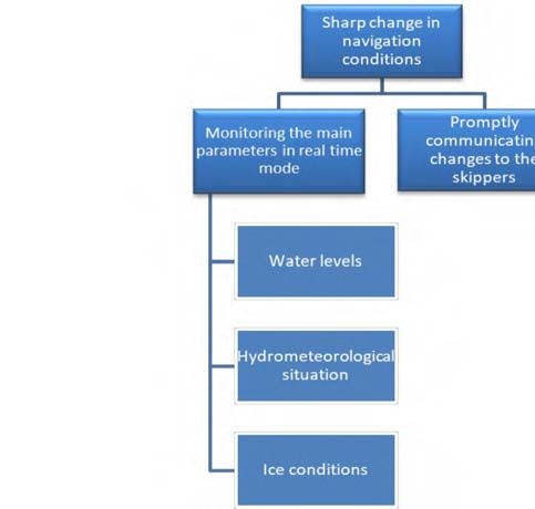
E3S Web of Conferences 258, 02004 (2021)                                    https://doi.org/10.1051/e3sconf/202125802004
UESF-2021

             As a result of the experiment, it was found that when moving along the section under
         consideration using only radar for observation, it is necessary to correct the vessel’s course
         according to reliable radar landmarks, which can be considered capes, channels, and
         characteristic outlines of the coast. Since the edges of the vessel’s course are shallow and
         rocky, and the depths beyond the edges on the shallows are small, the transition from one
         straight section to another should be carried out smoothly almost everywhere, which will
         ensure good vessel management and avoid delays and sharp changes in course. As an
         example, the section of the Ivanovskie Rapids is considered, its complexity is due to a
         combination of reasons, among the main ones we can single out: a sharp change in the
         directions of straight sections of the vessel course, alternation of narrow and wide sections,
         the action of dump streams, significant stream speeds, variability of streams depending on
         the water level and location (fig. 6).

         Fig. 6. Display on the all-round view indicator of the radar of the speed vector of the vessel in a
         curved movement during the turn to the aft Upper Pellovsky target.
             Based on the results of the settlement vessel’s runs on the difficult for navigation
         section of the Ivanovskie Rapids and the study of the traffic course with the analysis of the
         influence of external factors on the vessel, it was decided that it is necessary to set the
         minimum number of floating signs of navigation equipment at four points:
             - to indicate the intersection point of the Upper Pellovsky and Lower Pellovsky targets.
             - for the prevention of vessel deviation in the direction of Bolsheporozhskaya luda when
         rounding Cape Svyatki;
             - to evaluate the start point of rotation around Bolsheporozhskaya luda;
             - for orientation when making a rotation around Novoderevenskaya luda.
             The use of only ECDIS without floating navigational marks when passing the
         Ivanovskie Rapids section, which is difficult for navigation, can significantly increase the
         navigational safety of navigation, due to sharp changes in the directions of straight sections
         of the vessel course, alternation of narrow and wide sections, the action of dump streams,
         significant stream speeds, variability of streams depending on the water level and location
         (fig. 7).

                                                             5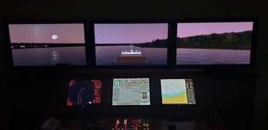
E3S Web of Conferences 258, 02004 (2021)                                  https://doi.org/10.1051/e3sconf/202125802004
UESF-2021

         Fig. 7. A fragment of an electronic navigation map of the most dangerous part of the difficult for
         navigation section of the Ivanovskie Rapids, without displaying signs of floating navigation
         equipment
             Thus, for the successful implementation of the extension of navigation period, the use of
         up-to-date electronic navigation maps is a prerequisite. A prerequisite for ensuring the
         safety of navigation during the period of extension of navigation is the deployment of an
         infrastructure for regular proofreading of electronic navigation maps and bringing maps to
         the end users. The Neva River basin is provided with high-quality cellular coverage, so it
         seems appropriate to transmit proofreading data via a cellular communication channel.
         Lake Ladoga has cellular coverage only in some coastal areas, so we need to get the latest
         proofreading data before going to the lake part.
             A sharp change in navigation conditions during the extended navigation period imposes
         the need for both monitoring the main parameters in real time and promptly communicating
         changes to the skippers. Real-time tracking is possible only with the use of automatic
         sensors, and the monitored parameters are water levels at various points, the
         hydrometeorological situation and ice conditions (fig. 8).

         Fig. 8. Areas of work associated with a sharp change in navigation conditions.

                                                            6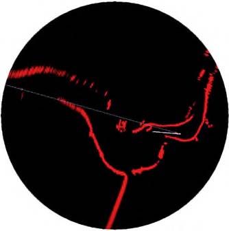
E3S Web of Conferences 258, 02004 (2021)                                 https://doi.org/10.1051/e3sconf/202125802004
UESF-2021

             Water levels and the hydrometeorological situation will be monitored using automatic
         stations, and it is advisable to use unmanned aerial vehicles of the airplane type to control
         the ice conditions.
             Prompt communication of information to skippers should be carried out through a
         specialized portal on the Internet. In the future, the resource of the River Information
         Service (RIS), namely, the Fairway Information Service, will be used for these purposes.

         3     Results
         Thus, the main areas of work to ensure navigation in the extended period are (fig. 9):
            - creation and regular proofreading of electronic navigation maps;
            - prompt delivery of the proofreading of electronic navigation maps to the skippers;
            - training of skippers in the use of electronic navigation maps in areas with-out floating
         navigation equipment;
            - installation of automatic water measuring posts, hydrometeorological stations and
         means of tracking ice conditions;
            - creation of a specialized portal on the Internet.

         Fig. 9. Areas of work associated with a sharp change in navigation conditions.

         4     Discussion
         The solutions proposed by the authors are quite expensive, if they are implemented starting
         from the “zero” cycle, at the same time, if the basin administration has this set of technical
         means (“Volgo-Balt” state basin administration” has ready-made solutions or at least their
         elements for each of the listed items) then we only need their “fine” tune to solve a specific
         task, which is extended navigation. As a result, it is possible to extend the period of use of
         inland waterways to ensure cargo turnover within the North-West region and make better
         use of the existing infrastructure, de-spite the presence of an objective limiting factor,
         which is the seasonality of navigation.

                                                           7
E3S Web of Conferences 258, 02004 (2021) https://doi.org/10.1051/e3sconf/202125802004
UESF-2021
5 Conclusion
The paper proposes a number of constructive measures confirmed by practical experiments
that allow the fullest use of the potential of the inland waterways of the Russian Federation
as one of the key systems of the transport complex of the Russian Federation.
The presented results were obtained during the implementation of the international project “Future
potential of inland waterways” (“INFUTURE”).
References
1. V. I. Babkin, A. V. Babkin, O. V. Merzlyi, Proceedings of the Russian State
Hydrometeorological University 54, 38–47 (2019)
2. A. V. Izmailova, Water Resources 43(2), 259–269 (2016)
3. S. Gänzle, Journal of Baltic Studies 48(4), 407–420 (2017)
4. E. S. Vakulenko, Economy of Region 16(4), 1193–120 (2020)
5. K. V. Purgin, A. D. Goncharov, Power Technology and Engineering 46(5), 374–376
(2013)
6. V. V. Karetnikov, A. A. Prokhorenkov, K. I. Efimov, A. A. Butsanets, IOP Conf.
Ser.: Mater. Sci. Eng. 918, 012091 (2020) doi:10.1088/1757-899X/918/1/012091
7. T. Hyla, W. Kazimierski, N. Wawrzyniak, Analysis of radar integration possibilities in
in-land mobile navigation, 16th International Radar Symposium (IRS) (2015)
8. V. V. Karetnikov, A. A. Prokhorenkov, Y. N. Lysenko, Bulletin of Admiral Makarov
State University of Maritime and Inland Shipping 12(3), 537–550 (2020)
9. N. Shilov, TransNav, the International Journal on Marine Navigation and Safety of Sea
Transportation 14(2), 405–410 (2020)
10. F. B. Pedersen, J. S. Møller, Hydrology Research 12(1), 1–20 (1981)
11. Y. Gao, X. Gan, W. Ai, DEStech Transactions on Engineering and Technology
Research (2019)
12. V. V. Karetnikov, I. V. Pashchenko, V.V. Kozlov, A. A. Butsanets, IOP Conf. Ser.:
Mater. Sci. Eng., 811(1) (2020)
8You can also read