SOUTH ISLAND MANAGEMENT PLAN SUMMARY 2020/2021 - Ernslaw ...
←
→
Page content transcription
If your browser does not render page correctly, please read the page content below
SOUTH ISLAND
MANAGEMENT PLAN
    SUMMARY

     2020/2021

                  Page | 1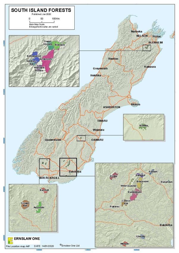
CONTENTS

   1                         INTRODUCTION ........................................................................................................... 3
   2                         COMPANY PROFILE .................................................................................................... 3
   3                         MANAGEMENT OBJECTIVES ..................................................................................... 4
   4                         FOREST RESOURCE ..................................................................................................... 4
   5                         SPECIES AND SILVICULTURE ..................................................................................... 5
   6                         HARVESTING ............................................................................................................... 6
   7                         WOODFLOW ................................................................................................................ 6
   8                         MAINTENANCE AND PROTECTION ........................................................................... 7
   9                         FOREST GROWTH AND DYNAMICS .......................................................................... 8
   10                        ENVIRONMENTAL PERFORMANCE ........................................................................... 8
   11                        CARBON FORESTRY .................................................................................................. 10
   12                        INDIGENOUS FLORA AND FAUNA ........................................................................... 10
   13                        EMPLOYMENT SUMMARY ........................................................................................ 11
   14                        OTHER FOREST USES ............................................................................................... 12
   15                        COMMUNITY INVOLVEMENT .................................................................................. 12
   16                        BLUE MOUNTAIN FORESTS.................................................................................... 14
   17                        APARIMA AND CLUTHA FORESTS ........................................................................... 15
   18                        NASEBY FOREST........................................................................................................ 16
   20                        MARLBOROUGH FORESTS ................................. ERROR! BOOKMARK NOT DEFINED.
   21                        CONTACT DETAILS........................................23ERROR! BOOKMARK NOT DEFINED.

FIGURES
FIGURE 1: ERNSLAW ONE LTD. SOUTH ISLAND FOREST LOCATION MAP ...................................................................................... 13
FIGURE 2: ERNSLAW ONE LTD. TAPANUI WORKING CIRCLE FOREST LOCATION MAP ................................................................... 17
FIGURE 3: ERNSLAW ONE LTDNASEBY FOREST LOCATION MAP .................................................................................................. 20
FIGURE 4: ERNSLAW ONE LTD. MARLBOROUGH FOREST LOCATION MAP..................................................................................... 23

TABLES
TABLE 1: SOUTH ISLAND ESTATE AREA SUMMARY AS AT 30TH JUNE 2019 ..................................................................................... 5
TABLE 2: STAFF AND CONTRACT CREWS EMPLOYED BY ERNSLAW ............................................................................................. 11
TABLE 3: TAPANUI WORKING CIRCLE FORESTS AREA SUMMARY AS AT 30TH JUNE 2019 ............................................................. 14
TABLE 4: TAPANUI WORKING CIRCLE FORESTS SUMMARY OF OPERATIONS 2018/19 .................................................................... 18
TABLE 5: CNASEBY FOREST AREA SUMMARY AS AT 30TH JUNE 2019 ......................................................................................... 18
TABLE 6: NASEBY FOREST SUMMARY OF OPERATIONS 2018/19 .................................................................................................. 19
TABLE 7: MARLBOROUGH FORESTS AREA SUMMARY AS AT 30TH JUNE 2019 .............................................................................. 21
TABLE 8: MARLBOROUGH FORESTS SUMMARY OF OPERATIONS 2018/19 .................................................................................... 22

                                                                                                                                               Page | 2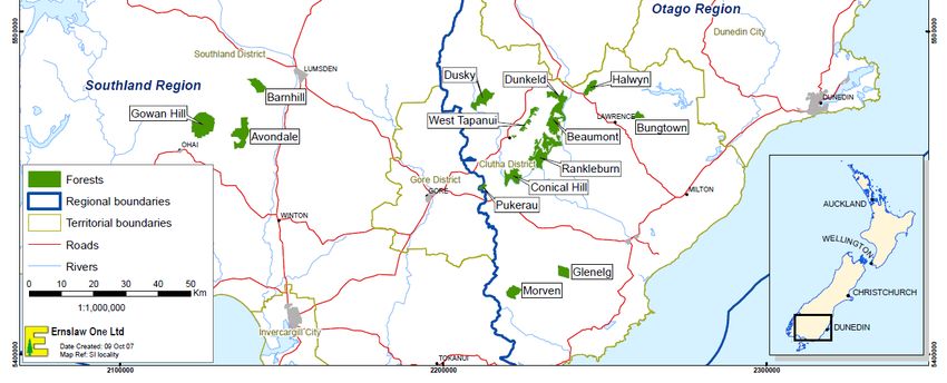
1   INTRODUCTION
This document is a summary of the Ernslaw One Limited (Ernslaw) Management Plan for the
South Island estate which is certified by the Forest Stewardship Council® (FSC®)
(FSC®C015328). FSC® certification is an internationally recognised standard that
demonstrates how a company’s forests are managed in an environmentally sound, socially
beneficial, and economically viable manner. Ernslaw certification was granted through
measurement of its operations and practices against the principles and criteria developed by
FSC® which define well managed forests.

Principle 7 requires Ernslaw to develop a management plan.

Principle 10 requires Ernslaw to explicitly state in the management plan the management
objectives of the plantation, including natural forest conservation and restoration objectives,
which are clearly demonstrated in the implementation of the plan.

The Principles state:

Principle 7: Management Plan - A management plan, appropriate to the scale and intensity of
operations-shall be written, implemented, and kept up to date. The long-term objectives of the
management, and the means of achieving them, shall be clearly stated”

Principle 10.1.1: Objectives of tree planting shall be explicit in the management plan, with
clear statements regarding the relationship between tree planting and the silviculture,
socioeconomic and environmental (i.e. forest conservation and restoration) realities in the
region.

Principle 10.1.2: Management objectives for conservation of natural forest and restoration shall
be described in the management plan.

Principle 10.1.5: Plantation management objectives, including explicit measures under Criteria
6.2, 6.3, 6.4, 6.9, 6.10, 10.2 and 10.5 intended to maintain and retain indigenous biodiversity,
are identified in the management plan and implemented in a timely manner.

Principle 10.1.6: The management plan shall identify the boundaries of the area encompassed
by the certificate, which includes the plantation forest plus any designated reserve areas.

This document is in fulfilment of Principle 7 and the relevant criteria of Principle 10. The first
part of this document describes the higher-level policies for the North Island estate. The second
part details the management plan of each forest under the Ernslaw Certificate SGS-FM/COC-
000905.

2   COMPANY PROFILE
Ernslaw is a private company, registered in New Zealand, with its owners based in Malaysia.
The company was established in 1990 when it purchased several Crown Forestry Licences
(CFL) of state forests from the government, as well as a sawmill. The company has since
bought more forests and more land which has been afforested. In 2011 a private company
TimberGrow Ltd (TGL) acquired forest estate in the Waihopai Valley. Ernslaw entered into
an agreement to manage this estate for TGL. Together with subsequent purchases in the region
by Ernlsaw One, these are referred to as the Marlborough Forests.

                                                                                           Page | 3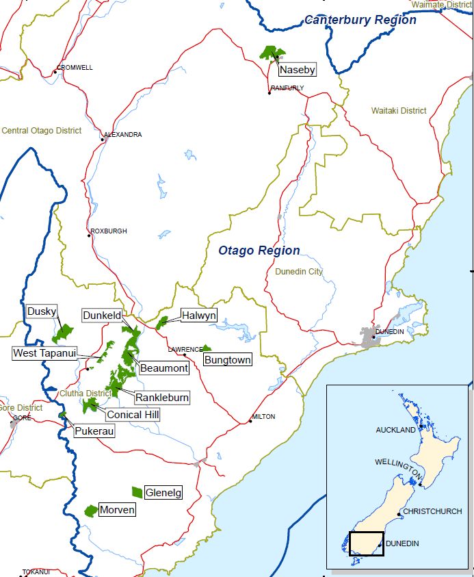
Contacts for key offices are below:

 Head Office                                     South Island Regional Office
 Private Bag 92826                               PO Box 36
 Penrose                                         TAPANUI 9542
 Auckland                                        Ph:(03) 204 8061
 Ph:(09) 622 2080
 Fax:(09) 622 2191

3   MANAGEMENT OBJECTIVES
Ernslaw is committed to creating sustainable softwood forests and delivering premium
quality appearance grade wood and panel board products for export and domestic customers.

Ernslaw has demonstrated its commitment to forestry in New Zealand by reinvesting
company earnings back into the New Zealand operation, as well as investing further capital.
This commitment has seen the New Zealand forest area to increase from the 23,987 hectares
purchased in 1990 to an area of 96,229 stocked hectares as at 30 June 2019 (including both
North Island and South Island). In addition to this is the 14,570 hectare forest estate managed
on behalf of TGL, and the land holding of FIL.

4   FOREST RESOURCE
The South Island forest estate under certificate SGS-FM/COC-0001037 is spread throughout
the South Island. The regional office in Tapanui, Regional Manager Phil De La Mare report to
the Chief Executive Officer, Paul Nicholls based in Auckland.

Forest blocks more distant from the regional offices have an office from which forestry and
harvesting operations are managed; this includes the Naseby office and Blenheim office. The
forest managed from the three offices are as follows:

          Naseby                             Tapanui                     Blenheim
    •   Naseby forest                 •   Blue mountains           • TimberGrow Waihopai
                                          forests.                   forests
                                      •   Aparima forests          • Ernslaw Waihopai
                                      •   Clutha forests             forests.

Ernslaw has entered into management agreements with TimberGrow Ltd. Therefore, the
resource of TimberGrow form part of the forest management unit making up the certification
area for Ernslaw.

The table over page gives a summary of the areas managed by Ernslaw and the tenure status of
each forest (South Island estate). (Note; the total productive area detailed in this document
includes the current stocked area, plus areas awaiting restocking.)

                                                                                        Page | 4
Table 1: South Island estate area summary as at 30th June 2019
Working Forest Tenure Mapped Productive
Circle Area (ha) area (ha)
Tapanui Avondale Freehold 2,946 2,463
Barnhill Freehold 1,414 1,186
Gowan Hill Freehold 4,302 2,752
Beaumont Freehold 3,238 2,608
Conical Hill Freehold 1,797 1,543
Dusky Freehold 2,057 1,723
Pukerau Freehold 254 233
Rankleburn Freehold 4,579 3,836
West Tapanui Freehold 819 653
Bungtown Freehold 479 390
Dunkeld Freehold 1,286 926
Glenelg Freehold 1,065 927
Halwyn Freehold 957 851
Morven Freehold 1,284 994
Naseby Naseby Freehold 2,523 2,069
Marlborough Renwick Freehold 1,385 1,186
Netherwood Freehold 1,299 836
Tordarroch Freehold 3,480 2,768
Sweet Stream Freehold 915 863
Wether Hill Freehold 514 449
Waihopai Downs Freehold 470 420
Total Ernslaw South Island 30,899 24,885
TGL South Island 6,164 4,791
Total under management 37,062 29,676
5 SPECIES AND SILVICULTURE
5.1 POLICY
The South Island estate focuses on growing three species; radiata pine, Douglas-fir and
Corsican pine
5.2 METHODS OF IMPLEMENTATION
Approximately 36% of the certified productive area is stocked with radiata pine, 59% with
Douglas fir and the balance in other species. The main species have been proven to grow
successfully in New Zealand and perform extremely well compared to other species. They can
be grown on a wide range of sites, have minimal associated pests and diseases, and when
Page | 5purchasing land, the company has selected areas that are suitable for radiata pine or Douglas
fir.
Ernslaw mostly establishes either improved controlled pollinated (CP) radiata pine tree stock
or improved 2nd generation seed orchard open pollinated Douglas fir tree stock. This stock
results in faster growth, increased volume and enhanced wood properties at harvest time. The
target stocking for Radiata planting is 1100 stems/hectare across all sites and other species are
planted at 1667 stems/ha. The processes, regimes and other operational guidelines are detailed
in the Ernslaw Establishment and Silviculture Manual. The manual has been reviewed and an
updated version made available in November 2018. This manual is a ‘dynamic’ document,
which is subject to periodic updates as required. The most recent was including guidance on
the topic of the National Environmental Standard for Plantation Forestry (NES-PF)
6 HARVESTING
6.1 POLICY
Production forest harvesting is undertaken in an economically, environmentally and socially
sustainable basis with safety as a primary focus.
6.2 METHOD OF IMPLEMENTATION
Harvesting includes both production thinning, where terrain permits, and clear-fell harvest of
mature stands. Harvesting is carried out by contractors using a mixture of ground based and
hauler techniques, depending on the terrain.
The detailed process of harvest planning is described in the Ernslaw Harvesting Manual. A
harvest plan is written which describes the method by which timber will be safely harvested
and transported from a forest area with minimal environmental impact. Topography, landing
requirements, design, location, and spacing of roads and landings, environmental constraints,
statutory and voluntary compliance requirements must be analysed, balanced and considered
in order for harvesting operations to occur with maximum efficiency and minimal disturbance.
Forest management software tools are used to analyse various scenarios in order to select the
optimal harvesting layout for any given cut plan area.
7 WOODFLOW
7.1 POLICY
The company has two general regimes for growing radiata pine; clearwood and panel board.
In addition to this is a small amount of chip and firewood taken from production thinning’s and
clear-fell.
1. The clearwood regime focuses on producing pruned clearwood for appearance end
uses. Pruning is done in 2-3 lifts and aims to produce a pruned butt log of at least 5.2
m with sawlogs above that.
2. The panel board regime aims to produce a structural grade log with small branching
that could be used in the production of plywood and other panel board products.
These regimes vary slightly between forests, as they have been customised for the local site
conditions.
Page | 67.2 METHODS OF IMPLEMENTATION
Ernslaw’s current sustainable harvest levels will vary among forests over time due to differing
age classes. The annually produced Estate Plan will define these levels. The Estate Plan and
harvest volume is determined using Remsoft Spatial Planning System (Woodstock), a spatial
linear programming tool.
Clear fell harvest volumes will remain static and increase around the year 2035 when new
forests established in the Aparima and Clutha districts reach maturity and harvesting
commences. In the meantime, from 2020 the volume of Douglas fir produced from production
thinning operations will increase dramatically.
Currently around 50% of the Ernslaw South Island volume is sold domestically, with Ernslaw
supplying logs to up to ten domestic sawmills and one MDF mill in Southland and Otago. The
remaining 50% is exported in log form. The primary export destination is China.
8 MAINTENANCE AND PROTECTION
8.1 POLICY
1. To actively participate in rural fire committees.
2. To control pest animals and pest plants in accordance with the Integrated Pest
Management Strategy, District Council Regional Pest Management Strategy and
Animal Health Board requirements.
8.2 METHODS OF IMPLEMENTATION
Ernslaw maintains its own fire-fighting equipment (including fire engines) and has its own
fire stores. Ernslaw staff are trained in a variety of fire related roles including operations,
planning and logistics to combat forest fires.
Up to the 30th June 2017 Ernslaw had been aligned with Rural Fire Authorities of which (by
district) were coordinated by the National Rural Fire Authority. Following a 2012 and 2015
review of fire services in New Zealand the Fire and Emergency New Zealand Act 2017 was
instated and Fire and Emergency New Zealand (FENZ) was established in July 2017. All
South Island forests now come under the FENZ Authority with reported forest fires being
directed through the National 111 emergency system of which is then coordinated by the
appropriate Principle Rural Fire Officer (PRFO).
During 2018 the Forest Health Surveillance (FHS) system was replaced by the Forest
Biosecurity System (FBS). This system takes the focus of assessment to those areas
identified as high risk, i.e. airports, shipping ports, industrial facilities etc. It is in the
environs surrounding these locations that plantation species are assessed for pest and disease.
A component of the budget for this system is available for non-model allocation sites, and as
such some forests may be subject to a field visit.
Foliage samples are taken from stands on an as needed basis to determine nutrient status, as
per foliar sampling policies by region. Stands found to be deficient will then be fertilised if
deemed necessary. With the exception of boron deficiency at Naseby and Marlborough
forests, no common nutrient deficiencies have been observed.
Page | 79 FOREST GROWTH AND DYNAMICS
9.1 POLICY
1. To adopt a variety of techniques to monitor forest growth and dynamics.
2. All stands and forest operations are recorded on a computerised stand record system.
9.2 METHODS OF IMPLEMENTATION
Ernslaw uses a number of software tools to manage the tree crop and assist with growth and
volume predictions. These include YTGen (yield table generator) and Atlas Forecaster.
These tools are used to model development of a forest and to assist with timing of pruning
and thinning operations, compare and develop regimes, and predict log grade and harvest
yield at harvest time.
Quality control is carried out after each tending operation. This provides information on the
number of trees per hectare, their size, and how well the tending was carried out. Permanent
sample plots (PSP’s) are installed in a selection of forests and stands throughout the South
Island estate following tending and obtain regular measurement for the life of each stand.
Atlas GeoMaster is a stand record repository system. GeoMaster has an interface that allows
information to be linked to the mapping software (Arc GIS) enabling forest, compartment and
stand areas to be spatially displayed. This capability assists forest managers with planning
and managing the forest estate.
Forest inventory data is collected using both traditional MARVL assessments and more
recently LiDAR imputation methodology.
10 ENVIRONMENTAL PERFORMANCE
10.1 POLICY
• To set high standards for all operations, especially harvesting, to minimise the effect
on the environment.
• To monitor streams to confirm that forestry and harvesting operations have not
impacted upon riparian function.
• To confirm that Ernslaw and its contractors meet the legal requirements and standards
outlined in the Environmental Management System (EMS) through audits and
identifying means for continuous improvement.
10.2 MANAGEMENT OBJECTIVES
The management objectives under our EMS are:
• To meet both voluntary and statutory requirements
• To improve our environmental performance
• Benefit from a strong environmental reputation
Page | 810.3 METHODS OF IMPLEMENTATION
Ernslaw has had an EMS in place since 1998. The EMS identifies our processes and
procedures, who is responsible for these and our Best Management Practices. It incorporates
an Environmental Incident Procedure, Heritage Site Management, and a Riparian
Management and Monitoring Strategy. The EMS covers Consents and Permits, both internal
and external communication and incorporates an audit and review process. The audit process
measures how Ernslaw operations meet the voluntary and statutory environmental
requirements and identifies opportunities for further improvement. The EMS is a
comprehensive document that allows us to meet a high standard of environmental
performance.
In May 2018 the National Environmental Standard for Plantation Forestry (NES-PF) came
into force. These regulations are made under the Resource Management Act 1991 (RMA)
and significantly changed how plantation forestry is regulated within New Zealand. The
regulations set out technical standards, methods or requirements relating to matters under the
RMA and provide consistent rules across the country. The NES-PF prevails over district or
regional rules except where the NES-PF allows more stringent plan rules. The EMS is
currently in the process of being updated to reflect the NES-PF.
Ernslaw has, along with most New Zealand Forest Owners, ratified the New Zealand Forest
Owners Association Environmental Code of Practice and uses this document alongside the
EMS. In 2018, the Forest Practice Guides were released by NZFOA and are accepted
industry guides for a range of forestry activities. EOL has adopted these guides for relevant
forestry activities.
Ernslaw South Island has over 100 archaeological sites within its estate, primarily gold
mining sites. The majority of these are at Naseby forest. Archaeological surveys are
conducted prior to harvest and sites are recorded in the GIS and marked on maps. Authority
is received from Heritage NZ prior to any operation likely to disturb historic sites. Staff and
contractors are trained to identify and report new sites.
The EMS contains a section entitled “Vista Management for Outstanding Landscapes” to
summarise the known outstanding landscapes, how we can influence them and how we
should manage activities around them. We have reviewed the Integrated Pest Management
Strategy to convert two regional strategies into a national strategy for the company. This
process has included a review of chemical use procedures and development of a national
chemical use policy. This is now contained in the Establishment and Silviculture Manual so
staff can access the information they require when planning weed or pest control operations.
In November 2007 the Forest Owners Association released the New Zealand Environmental
Code of Practice for Plantation Forestry. These best practice guidelines have been adopted
by Ernslaw. In 2018 the Forest Practice Guides were released by NZFOA and are accepted
industry guides for a range of forestry activities. EOL has adopted these guides for relevant
the forestry activities.
As part of a continual process to reduce the use of agrichemicals Ernslaw has introduced a
weed assessment protocol to be employed post-harvest and in the two years following re-
planting. The intention is that only stands requiring treatment will have residual herbicide
applied. Others will receive an alternative treatment if required. Chemical use is reported
annually as part of the FSC audit process.
Page | 9EOL undertakes an annual water monitoring programme using the Stream Health Monitoring
Assessment Kit (SHMAK) to assess water quality trends over time and measure the effects of
our activities on freshwater values. In addition Ernslaw is a partner in the Pomahaka River
Catchment Group and collects water samples from several streams monthly for analysis. In
addition, Ernslaw has its own freshwater ecologist who is midway through a 2 year
programme of surveying every stream on the estate for the presence of indigenous and exotic
fish life.
Ongoing evaluations of indigenous vegetation within the estate are undertaken to identify and
assess ecosystem values. Management priorities are then planned according to the
associated value. Assessments are progressed both at a course and fine level in order to
identify vegetation types, distribution of rare, threatened and endangered species, threats to
the ecosystem and to develop management requirements.
Additionally, the estate has been assessed for areas that are of High Conservation Value
(HCV). Ernslaw has undertaken an extensive analysis and consultation process to identify
and assess potential HCV areas. Currently 27.9 hectares have been classified as having HCV
and management plan has been developed for each area which includes an annual monitoring
programme. Ernslaw will continue to re-assess and consult with local experts on areas that
have potential HCV and make management plan amendments where necessary.
Carbon Forestry
With the passing of the Climate Change Response Act 2002, the scene was set for
development of initiatives to assist with addressing climate change. The creation of the
Emissions Trading Scheme (ETS) has provided Ernslaw with an opportunity to derive
additional value from the forest resource, through the sale of carbon credits.
Throughout the 1990’s Ernslaw developed new radiata pine forests on company owned
freehold land which had not previously been under forest cover. As these are forests
established after 1990 i.e. Post-1989 forests, they are eligible for entry into the ETS. Since 1st
September 2011 forest companies were able to install sample plots in their own post-1989
forest land. With information collected from these plots, Te Uru Rākau (formerly MPI)
provided a specific carbon lookup table to be used for calculating carbon stocks instead of
using regional lookup tables.
The South Island has three forest groups entered into the ETS:
• Aparima forests (Western Southland)
• Clutha Forests (Otago)
• Waihopai Forests (Marlborough)
Since TGL has acquired forest estate in New Zealand, they have entered all their eligible
North and South Island estate into the ETS.
11 INDIGENOUS FLORA AND FAUNA
11.1 POLICY
1. Forest operations are carried out so that threatened species and their habitats are not
disturbed.
Page | 102. Effects of forestry operations on indigenous vegetation distributed throughout
Ernslaw’s estate, designated as Significant Natural Areas (SNA’s) are avoided,
remedied or mitigated.
11.2 METHODS OF IMPLEMENTATION
Ernslaw is a member of the New Zealand Forest Owners Association and is a signatory to the
Forest Accord. The Accord does not allow conversion of areas of tall indigenous vegetation
greater than five hectares to plantation forestry. It has always been the policy of the company
to adhere to the Forest Accord and to protect areas of indigenous vegetation.
Ernslaw has developed an estate map to show areas of indigenous flora and fauna. An array of
management options exists to mitigate adverse effects on indigenous species within the South
Island estate. Management strategies have been established for falcon (Falco
novaeseelandiae).
An agreement between Ernslaw and the Department of Conservation (DOC) ensures the
company does not compromise the protection efforts for Mohua (Mohoua ochrocephala) in the
Rankleburn conservation estate
Any indigenous species found within the estate have been recorded in the Ernslaw Arc GIS.
This work is an important part of the identification and protection of rare, threatened and
endangered species and their habitats. The Rare and Threatened Species Plans Identification
and Management Summary are an additional tool for contractors and staff.
In situations where forest operations could potentially have an adverse effect on SNA’s,
and/or the habitats of threatened indigenous species, relevant stakeholders will be consulted
prior to works commencing.
Additionally, Ernslaw uses the i-Naturalist platform to record sightings of native species
within the forest estate.
12 EMPLOYMENT SUMMARY
Ernslaw employs 10 salaried staff in the South Island. All other work is carried out by a contract
work force comprising harvesting, harvest roading and forest silviculture, logging transport is
also contracted, this means there can be 100 people working within Ernslaw forests at any time.
Most of these people live locally to the forests. The number of staff and crews is summarised
in the following table.
Table 2: Staff and contract crews employed by Ernslaw and TGL
Office Staff Harvesting Roading Silviculture
Tapanui 10 4 1 6
Naseby 1 1 - 1
Marlborough 1 - 1 2
Page | 1114 OTHER FOREST USES
The forests also provide a number of other uses. These comprise commercial uses such as
grazing, sites for beehives, possum trapping for fur, and recreational uses such as hunting of
pigs and deer, mountain biking, adventure races, orienteering and others.
15 COMMUNITY INVOLVEMENT
Ernslaw One has a close involvement with the local communities around its forests. Most of
the labour force comes from those communities. Ernslaw One supports many of these
communities by way of scholarships and sponsorships. School groups will also visit forests for
an educational experience. Forests are used by local hunters, and also a number of sporting
organisations, e.g. mountain bike clubs, car rally’s, orienteering and others.
Page | 12Figure 1: Location map of the Ernslaw South Island managed estate.
Page | 1316 TAPANUI FORESTS
The Tapanui forests are divided into three groups Blue Mountains, Aparima and Clutha. All
forests are freehold.
Table 3: Tapanui forests area summary as at 30th June 2019
Forest group Total area (ha) Productive area (ha)
Blue Mountains 12,747 10,456
Aparima 8,662 6,358
Clutha 5,182 4,084
Total Area 26,591 20,898
16.1 BACKGROUND
The Blue Mountain forests are located in the Tapanui area, approximately 40 km north-west of
Gore. The forests have a total area of 11,867 hectares, of which 8,136 hectares is stocked.
There are twelve forest blocks, comprising Dusky, West Tapanui, Conical Hill, Pukerau,
Rankleburn, and Beaumont the majority of the land was first planted in the early 1900s and
through to the 1980s by the New Zealand Forest Service. Previous tenure was under CFL then
leased from Ngai Tahu, but all forests are now owned freehold by Ernslaw One.
16.2 HARVESTING
Harvesting continues in all blocks. Some blocks are now into the fourth rotation. Both
haulers, fully mechanised and motor manual ground based crews are utilised.
16.3 SILVICULTURE
These forests are mostly Douglas fir (61%). Where terrain permits, stands are production
thinned the balance are waste thinned. With the Radiata resource, a variety of silvicultural
approaches in the past has given a wide range of treatments and stockings. Stands planted by
Ernslaw have been stocked with radiata pine applying either a clearwood regime or structural
regime, depending on site productivity. The company contracts four full time silviculture crews
who work throughout estate.
16.4 ENVIRONMENTAL
Ecological surveys have revealed the presence of Native falcon throughout the Blue mountains
and nationally threatened Mohua are present in Native beech forest adjacent to the Western
edge of Ranklburn forest.
Forestry operations likely to impact on these species and their habitats are planned and
managed under the species management plan and where required in consultation with the DOC
and other stakeholders.
Mohua are particularly at risk from predation by mustelids and rodents in years of heavy
flowering in the adjacent (DOC) Silver beech forests. Ernslaw One work with the Department
Page | 14of Conservation to enable control of these pests to ensure the survival of this threatened bird
species. Following the heaviest Beech mast in a generation, in November 2019 the Rankleburn
area was poisoned with 1080 to control pest numbers.
There are a small number of known archaeological sites in the Blue Mountain Forests. These
were recorded up to thirty years ago and are included in GIS mapping layers. From time to
time new sites are found as operations and or planning progresses through areas.
With sensitive receiving waters of the Pomahaka and Clutha rivers bordering the forests, water
quality, specifically sediment yield are closely monitored with independent monthly water
quality tests conducted at several sites throughout the forest.
16.5 OTHER
The Blue mountains has a long history of recreational hunting for pigs and Fallow deer in
both the native forest (Department of Conservation estate) and commercial plantations.
Ernslaw One provide weekend hunting opportunities to over 200 registered hunters annually
through an online ballot system for 12 hunting blocks across the estate. This amounts to over
1000 exclusive hunting ballots annually.
17 APARIMA FORESTS
17.1 BACKGROUND
The Aparima forests, are located in the Tapanui region, and are located approximately 75 km
north west of Invercargill. The forests have a total area of 8,662 hectares, of which 6,358
hectares is stocked.
There are three forest blocks, comprising Gowan Hill, Avondale and Barnhill all of which were
former sheep and cattle farms and were purchased by Ernslaw in the mid 1990’s. The majority
of land was planted in Douglas fir from 1994-2000.
17.2 HARVESTING
Harvesting is currently limited to production thinning and is carried out by one mechanised
crew consisting of 2 wheeled harvesters supported by one forwarder.
17.3 SILVICULTURE
This forest is predominantly stocked with Douglas fir. Trees were planted at stockings ranging
from 1500 - 1750 stems/hectare. As for the Blue mountains where terrain permits stands are
production thinned from age 22 onwards. Steeper areas have been waste thinned at 15m MTH
or left un-thinned as carbon forest.
Page | 1517.4 ENVIRONMENTAL
Ecological surveys have revealed the presence of Falcon and most streams have resident
populations of Koura. Forestry operations likely to impact on these species and their habitats
are planned and managed under the species management plan.
A 20-hectare QEII tussock reserve covenant isolated from the forests but close to the Aparima
river has been classified as HCV-3 in order to maintain an example of lowland Red tussock,
which prior to clearing for pastoral farming covered much of Southland.
17.5 OTHER
The Ernslaw One freshwater crayfish business, Keewai, has significant infrastructure
investment in this forest with over 1200 ponds located in wet areas which provide ideal habitat
for the nationally rare crustacean species Koura.
Recreational hunting opportunities are also provided free of charge to local hunters.
18 CLUTHA FORESTS
18.1 BACKGROUND
The Clutha forests are located in the Tapanui region, around the township of Lawrence and in
the Catlins district of South Otago. The forest has a total area of 5,182 hectares, of which 4,081
hectares is stocked.
There are five forest blocks Dunkeld, Halwyn, Bungtown, GlenElg and Morven. All are
freehold and were planted between 1998 and 2000.
All blocks are first rotation forest planted on reverting farmland.
18.2 HARVESTING
To date no clear fell harvesting has occurred in these forests. Production thinning of selected
Douglas fir areas is budgeted to begin from 2020.
18.3 SILVICULTURE
The Dunkeld and Halwyn blocks are planted partially with radiata and the balance Douglas fir,
the remainder are predominantly Douglas fir. Radiata has been managed on a clearwood regime
and the Douglas fir is being managed on both waste thinned and production thinning regimes
for structural timber. Silviculture crews are shared with the Blue Mountains forests working
circle.
18.4 ENVIRONMENTAL
Within Morven forest, 7.60 hectares have been classified as HCV-3 in order to protect a
wetland which is classed as significant in the context of the Ecological District. A management
plan is in place and the site is monitored by annual inspections.
Page | 1618.5 OTHER
Like the Aparima forests both Morven and GlenElg forests have a number of koura ponds
stocked with fish as part of the Keewai business unit. Weekend hunting opportunities are
likewise provided to Ernslaw contractors and local hunting groups.
Figure 2: Ernslaw One Ltd. Tapanui working circle forest location map
Page | 17Operations (Tapanui)
Table 4: Tapanui forests summary of operations as at 30th Dec 2019
Operation Quantity
Harvesting (t) 159,000
Pre-plant Aerial Spraying (ha) 320
Restocking/planting (ha) 320
Thinning (ha) 735
19 NASEBY FOREST
19.1 BACKGROUND
This forest estate was purchased by Ernslaw One in 2001. Naseby is located in the Maniototo
district surrounding the township of Naseby some 90km north east of Alexandra.
The forest is 2,522 hectares one of the oldest in New Zealand having been first planted by the
NZ forest service at the turn of the 20th century. Naseby and the surrounding forest are a
popular tourist destination in both summer and winter when people come to pursue outdoor
activities including sports such as curling and dog sledding.
Table 5: Forest area summary of Naseby forest as at 30th June 2019
Forest block Region Total area (ha) Productive area (ha)
Naseby Tapanui 2522 2081
19.2 HARVESTING
Harvesting is currently carried out by one mechanised crew.
19.3 SILVICULTURE
These forests are predominantly planted in Corsican pine, or Douglas fir. In addition, hardy
Radiata x Pinus attenuata hybrids are also planted in stands adjacent to sensitive boundary areas
to mitigate the threat of wilding conifer spread. Because of its long history many alternative
species were trialled in the early years and remnants of these are still being managed and
harvested. This includes Pinus contorta which is a noxious pest plant known to spread onto non
intensively managed land. Considerable effort is put into containing this weed species within
the forest.
A variety of silvicultural regimes, including pruned and unpruned regimes, have been used in
the past. Current silviculture is focussed on thinning young stands to remove natural
regeneration and wilding conifer management in other waste areas. Silviculture operations are
carried out by crews from the South Otago area on an as required basis.
Page | 1819.4 ENVIRONMENTAL
Much of the forest lies on top of the Naseby Goldfields which were worked for nearly a century
from the 1860’s onwards. This has created a landscape rich in archaeological history which the
company is careful to protect, particularly during harvesting and land preparation operations.
There are hundreds of known archaeological sites in Naseby forest, and more sites are found
from time to time during operational processes. These sites have been mapped assessed and
registered with Heritage New Zealand and are taken into consideration during planning for
subsequent forest operations.
NZ falcon are identified as present in Naseby forest and are managed under species
management plans.
Naseby forest is popular with visitors to the Central Otago region. With over 70km of walking
and Mountain bike tracks in the forest it is estimated that more than 10,000 visitors a year enjoy
recreation opportunities in the forest.
19.5 OTHER
Naseby forest is prone to climatic extremes of cold in winter and heat in summer as well as
receiving low summer rainfall. Therefore, the forest has a high number of extreme fire risk
days annually, which because of its proximity to the township require constant vigilance to
avoid wildfire.
19.6 OPERATIONS (NASEBY)
Table 6: Naseby forest summary of operations as at 30th Dec 2019
Operation Quantity
Harvesting (t) 12,000
Pre-plant Aerial Spraying (ha) 40
Restocking/planting (ha) 60
Thinning (ha) 25
20 CONTACT DETAILS (TAPANUI FORESTS)
Ernslaw One Ltd:
PO Box 36
TAPANUI 9542
Ph: (03) 204 8061
Page | 19Figure 3: Naseby forest location map
Page | 2021 MARLBOROUGH FORESTS
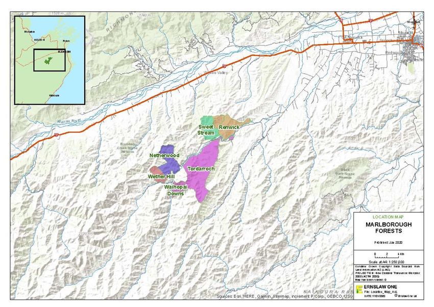
21.1 BACKGROUND
The Marlborough forests form a cluster in the mid Waihopai valley approximately 40km South
West of Blenheim. The forests have a total area of 8,062 hectares, of which 6,353 hectares are
productive. They comprise several blocks, as listed below. With the exception of Renwick
forest, which was purchased as a mid-rotation forest, the forests were afforestation projects.
All blocks are freehold title (Ernslaw or TimberGrow owned).
21.2 AREA SUMMARY
Table 7: Marlborough forests area summary as at 30th June 2019
Tenure Forest block Total area Net stocked area
(ha) (ha)
TimberGrow Renwick 1,385 1,186
Tordarroch 3,480 2,768
NetherWood 1,299 836
Ernslaw One Wether Hill 514 449
Waihopai Downs 470 420
Sweet Stream 915 863
Total 8,062 6,522
The forests are planted on marginal hill country pasture and scrubland. The terrain is steep.
21.3 HARVESTING
Most of the area has only been planted since 2011 so no harvesting is imminent. Harvest
operations will likely begin in the Renwick forest, planted 1994-1996, from 2022 onwards.
21.4 ESTABLISHMENT / SILVICULTURE
With the exception of small areas planted in Douglas fir, poplar and Cypress species the
overwhelming majority of these forests are planted with radiata pine. Trees are planted at 715
stems/hectare with improved genetic material often cuttings. Stands will be managed on a
structural log regime. Better sites may be pruned to a minimum height of 5.5 m, and then
thinned (waste or production) to a final stocking of 333 stems/hectare. The remainder of the
forest will remain unthinned resulting in a final crop stocking of approximately 650
stems/hectare under a structural regime. The company contracts two part time silviculture
crews, primarily for planting. Some areas are fertilised with Ulexite to lift boron levels which
can be low on east coast dryland soils.
Page | 2121.5 ENVIRONMENTAL
Independent ecological surveys have been conducted across the majority of the forest estate,
both prior to and post forest establishment. These have resulted in over 1,500 ha being set
aside in protected reserves.
In 2020 a further survey is being conducted by an independent ecologist to establish whether
parts of this area warrant additional protection as FSC high conservation value forest. The
forests are directly downwind of a known wilding conifer affected part of the conservation
estate so there is a real risk of wilding conifer spread into alpine grasslands above the forest.
Therefore, Ernslaw regularly assess invasion and where necessary implement control
measures of the unwanted conifers.
21.6 OTHER
The forests are quite close to the urban centres of Renwick and Blenheim, which results in high
recreational demand principally for hunting. Like other blocks owned by Ernslaw One hunting
is managed to provide exclusive weekend hunting opportunities to selected hunting parties.
Some of the Marlborough forests are grazed by neighbours and nearby apiarists locate beehives
in the forests also.
TimberGrow also has a truffe orchard with several
These forests are often subjected to hot dry summers and when these occur the fire risk becomes
extreme. In this situation, access may be restricted to the public, and even forest operations
may be curtailed.
21.7 OPERATIONS
Table 8: Marlborough forests summary of operations as at 30th December 2019
Operation Quantity
Harvesting (m3) -
Pre-plant Aerial Spraying (ha) 150 ha
Restocking /planting (ha) 150 ha
Aerial releasing (ha) 150 ha
Page | 22Figure 4: Marlborough forest location map
22 CONTACT DETAILS
Marlborough Forests or South Island Regional Office
11 Harvard Road 91 Cemetery Road
Burleigh PO Box 36
BLENHEIM TAPANUI 9542
Ph: (027) 447 7591 Ph: (03) 204 8061
Page | 23You can also read