Strategic Assessment 2021 - April 2021 Version 1.0 - Avon Fire & Rescue Service
←
→
Page content transcription
If your browser does not render page correctly, please read the page content below
Strategic Assessment
2021
April 2021
Version 1.0
Document history

         Review date               Version       Summary of changes
          07/05/2020                 0.1         Initial drafting
          15/03/2021                 0.2         Final drafting
          30/03/2021                 1.0         Taken out of draft

    Document owner:     SM Integrated Risk Management Planning

    Document authors: SM Integrated Risk Management Planning
                        IRMP Co-ordinator
                        Risk Intelligence Interns

Avon Fire & Rescue Service is committed to ensuring our documents are accessible to
all members of the community.

If you have difficulty reading this document because English is not your first language
and you would like a translation or you require a version in another format e.g. in braille,
or audio format, please contact:

Diversity, Inclusion, Cohesion and Equality Team, Avon Fire & Rescue Service, Police
& Fire Headquarters, PO Box 37, Valley Road, Bristol, BS20 8JJ.

Telephone: 0117 926 2061

Email: DICE@avonfire.gov.uk

Notes:

This is a controlled document and is designed for back-to-back printing in accordance
with the principles outlined in the Government Security Classifications April 2014.

Unauthorised reproduction in whole or in part is strictly prohibited.

© Avon Fire & Rescue Service 2021

2                                                          Strategic Assessment 2021 v1.0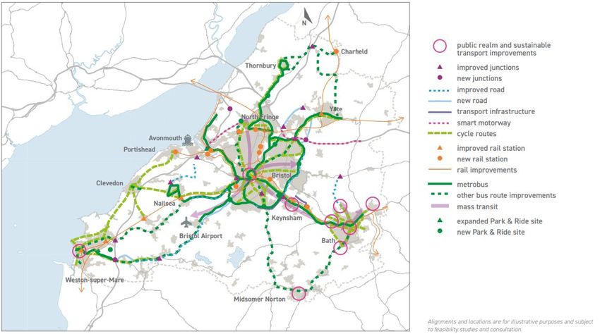
Contents
Executive Summary ........................................................................................................ 5

1. Our Service Area ...................................................................................................... 6
  1.1. Introduction ........................................................................................................ 6
  1.2. Demographics.................................................................................................... 7
  1.3. Social ............................................................................................................... 12
  1.4. Environment..................................................................................................... 21
  1.5. Economy .......................................................................................................... 24
  1.6. Planned Developments .................................................................................... 25
  1.7. Politics ............................................................................................................. 32

2. Our Organisation .................................................................................................... 35
  2.1. Introduction ...................................................................................................... 35
  2.2. Operational Preparedness and Resilience....................................................... 35
  2.3. Operational Response ..................................................................................... 37
  2.4. Pensions .......................................................................................................... 38
  2.5. Pay Awards ...................................................................................................... 38
  2.6. Gender Pay Gap Reporting ............................................................................. 39
  2.7. National Fire Chiefs Council (NFCC) ............................................................... 39
  2.8. The Formation of Fire Standards Board........................................................... 40
  2.9. Procurement .................................................................................................... 40
  2.10. Technology ................................................................................................... 40
  2.11. Health, Wellbeing and Morale....................................................................... 42
  2.12. Her Majesty’s Inspectorate of Constabulary and Fire & Rescue Services
  (HMICFRS)................................................................................................................ 43
  2.13. Legal ............................................................................................................. 44

3. National Risk Register ............................................................................................ 55
  3.1. Introduction ...................................................................................................... 55
  3.2. Environmental Hazards.................................................................................... 55
  3.3. Human and Animal Health ............................................................................... 60
  3.4. Major Accidents ............................................................................................... 62
  3.5. Societal Risks .................................................................................................. 63
  3.6. Malicious Attacks ............................................................................................. 64

Works Cited .................................................................................................................. 68

3
List of Illustrations and Tables
Table 1.1 Population by Unitary Authority                                           7
Table 1.2 Students enrolled at universities in our Service area                    11
Table 1.3 Obesity levels across the four Unitary Authorities                       13
Table 1.4 Smoking levels by Unitary Authority                                      14
Table 1.5 IMD rank for each Unitary Authority                                      18
Table 1.6 Listed buildings by Unitary Authority                                    23

Figure 1.1 Age profile of each Unitary Authority                                    7
Figure 1.2 Gender profile across all Unitary Authorities                            8
Figure 1.3 Religious profile of our Service Area                                    9
Figure 1.4 Ethnic profile of our Service Area                                       9
Figure 1.5 Tenure profile of Unitary Authorities                                   10
Figure 1.6 Mine workings and risk in our Service Area                              24
Figure 1.7 South West Joint Local Transport Plan Major Schemes                     27
Figure 3.1 Fluvial flood risk in the AF&RS Service Area                            58

4                                                       Strategic Assessment 2021 v1.0
Executive Summary
Welcome to the Avon Fire & Rescue Service (AF&RS) Strategic Assessment 2021. This
is a key document in our Corporate Planning process and documents our understanding
of our Service area and its risks.

The Strategic Assessment enables AF&RS to identify issues which have the potential to
affect the future strategic direction of the Service, as well as informing the Integrated
Risk Management Plan, and underpinning our Service Plan.

There will always be new elements that emerge which will have an impact on the
Service, and the period since the Strategic Assessment 2019/2020 has been no
exception. The last year has seen Climate Emergencies declared across the nation, the
UK’s departure from the European Union, the publication of the first stage of the
Grenfell Tower Inquiry, and the global impacts of the COVID-19 pandemic. These
events, amongst others, will be assessed in this document using the PESTELO
approach to analyse the political, economic, social, technological, environmental, legal,
and organisational factors that may affect the Service.

The Strategic Assessment 2021 will begin by identifying the existing and emerging
issues within the AF&RS service area. It will then move on to the issues that impact
AF&RS as an organisation. And finally, apply the issues contained within the UK’s
National Risk Register to the AF&RS context.

5
1. Our Service Area
1.1. Introduction
The AF&RS service area covers Bristol, Bath and North East Somerset (BANES), South
Gloucestershire, and North Somerset. This area has a residential population of more
than one million people living in over 450,000 homes, over an area of 512 square miles.

Located centrally within the service area, Bristol is the largest city covered by AF&RS,
and the largest in the South West region (Bristol City Council, 2020). Other population
centres covered by AF&RS are UNESCO World Heritage site Bath, and the seaside
resort town Weston-Super-Mare. Beyond these principal urban areas, there are a
number of market towns such as Nailsea, Radstock, Keynsham, Yate, and Thornbury,
and the coastal towns of Clevedon and Portishead. As well as this, there are rural
villages and hamlets scattered throughout the service area.

6                                                        Strategic Assessment 2021 v1.0
1.2. Demographics
1.2.1. Population
The latest population estimate of the AF&RS service area is 1,156,804 people (Office
for National Statistics, 2020). This marks an estimated increase of over 87,000 people
since the 2011 Census (Office for National Statistics, 2011).

As shown in Table 1.1 below, the largest percentage of the population are living in the
Bristol Unitary Authority, making it the most densely populated area served by AF&RS.
Table 1.1 Population by Unitary Authority (Office for National Statistics, 2020).
                              Area                                                  Population      Population
    Unitary Authority                     Area %           Population
                           (Hectares)                                                  %             Density

        BANES               34,574         26%               193,282                   16%             5.1

         Bristol            10,961          8%               463,377                   40%             39.1

    North Somerset          37,379         28%               215,052                   19%             5.4

        South
                            49,695         37%               285,093                   25%             5.3
    Gloucestershire

                                                                                                    Average =
          Total             132,609        100%             1,156,804                 100%
                                                                                                      13.7

By 2024, projections show a steady population increase over all four Unitary Authority
areas. South Gloucestershire is projected a 6% population increase, and Bristol,
BANES, and North Somerset are projected approximately 4% increases (Office for
National Statistics, 2020).

1.2.2. Age Profile
As shown in Figure 1.1 below, each Unitary Authority has a different profile when it
comes to age profiles. Bristol and BANES have younger populations, with the 15-29
year group making up the majority of the population. In contrast, in North Somerset the
majority of the population are in the 45-59 year age group, and in South Gloucestershire
the majority age group is equally 30-44 and 45-59 year olds.
    120000
    100000                                                                                            0-14
     80000                                                                                            15-29
     60000                                                                                            30-44

     40000                                                                                            45-59

     20000                                                                                            60-74
                                                                                                      75 & over
         0
                   B&NES                Bristol           North Somerset    South Gloucestershire
Figure 1.1 Age profile of each Unitary Authority (Office for National Statistics, 2020).

7
Children and young people make up a consistent proportion of each Unitary Authority,
with around 18% of each areas population between the 0-15 year age ranges (Office for
National Statistics, 2020).
Although over-75s make up the smallest demographic in all four Unitary Authorities,
there are still 93,699 over-75s in the service area (Office for National Statistics, 2020).
The National Fire Chiefs Council (NFCC) explain that people over 80 are 10 times more
likely to die in a fire than someone under 30. Therefore, while the over-75s age group
are not the biggest in AF&RS’s area, the risk of fire deaths is greater (NFCC, 2013).
Similarly, almost twice as many people over the age of 50 die in house fires as those
under the age of 50, highlighting vulnerabilities for South Gloucestershire and North
Somerset (NFCC, 2013).
1.2.3. Gender
The gender profile of the population within the AF&RS area shows an average of 49%
male and 51% female (Office for National Statistics, 2020). As shown in Figure 1.2
below, this ratio is similar across all four Unitary Authorities.
250000
200000
150000
Female
100000
Male
50000
0
B&NES Bristol North Somerset South Gloucestershire
Figure 1.2 Gender profile across all Unitary Authorities (Office for National Statistics, 2020).
1.2.4. Religion
As shown in Figure 1.3 below, the 2011 Census identified that within the AF&RS area,
54% of the population identifies as Christian, and 2% as Muslim. Those who consider
themselves as having no religion, or not stating one, are 34% and 8% respectively. In
addition, another four religions, as well as those selecting ‘other religion’ account for up
to 1% of the population each.
8 Strategic Assessment 2021 v1.0Christian 579,771
No religion 359,318
Religion not stated 84,355
Muslim 26,240
Other religion 5,555
Hindu 5,268
Buddhist 4,752
Sikh 2,991
Jewish 1,333
0 100,000 200,000 300,000 400,000 500,000 600,000 700,000
Figure 1.3 Religious profile of our Service Area (Office for National Statistics, 2011).
1.2.5. Ethnicity
The 2011 Census identified that over 90% of the population within AF&RS’s four Unitary
Authority areas were white. The remaining population were a mixture of other ethnic
groupings, which are shown in Figure 1.4 below.
Figure 1.4 Ethnic profile of our Service Area (Office for National Statistics, 2011).
1.2.6. Language
The 2011 Census has a classification for 102 languages, many of which have less than
0.1% representation within the population of the AF&RS service area. The most
9commonly spoken languages in the AF&RS service area, other than English, were
Polish, Somali, Chinese (all dialects), French, and Spanish (Office for National
Statistics, 2011).
Nearly three percent of households across the AF&RS service area do not have any
members that speak English as a main language, an additional three percent have at
least one but not all household members who speak English as a main language (Office
for National Statistics, 2011).
1.2.7. Employment
In the AF&RS service area, 79.7% of the economically active population are in
employment. Unemployment sits at 3.45% - higher than the average for the South West
but below the national average (ONS, 2019). In 2019, there were 38,100 workless
households in the service area (ONS, 2019).
Between October and December 2020, the National unemployment rate was 5.1%,
meaning that 1.74 million people across the UK are unemployed. This figure is expected
to continue to rise over the duration of the pandemic. The level of unemployment is
similar to levels seen in the late 1970’s and early 1980’s (Office for National Statistics,
2021). As the COVID-19 pandemic continues, national unemployment levels are
predicted to reach between 8.8% and 11.8% in 2021 (OECD, 2020). Young workers are
most vulnerable to these changes (OECD, 2020).
1.2.8. Housing
The 2011 Census shows that within the AF&RS area there are 468,167 households, the
majority of which (67%) are owner-occupied properties (Office for National Statistics,
2011).
As shown in Figure 1.5 below, those living in rented accommodation make up 15.5% of
households, a larger proportion of these live in the Bristol Unitary Authority area. There
are similar levels of households living in private or social rented accommodation (Office
for National Statistics, 2011).
Owned: Owned outright
South Glos
Owned: Owned with a mortgage or
North Somerset loan
Shared ownership (part owned and
Bristol part rented)
Social Rented
B&NES
0% 20% 40% 60% 80% 100% Private Rented
Figure 1.5 Tenure profile of Unitary Authorities (Office for National Statistics, 2011).
Single occupant households make up 31% of households in the service area; 40% of
those households are occupied by a person over the age of 65; a group identified as
more vulnerable to fire in section 1.2.2 Age Profile.
10 Strategic Assessment 2021 v1.01.2.9. Transient Population
The transient population in the AF&RS service area refers to those who are living here
temporarily.
Students
Students make up a large proportion of AF&RS’s transient population. There are
several universities in the Service area, with more than 84,000 students enrolled for the
2019/20 academic year.
Table 1.2 Students enrolled at universities in our Service area (University of Bristol, 2020; UWE Bristol, 2020;
Higher Education Statistics Agency, 2019).
University Number of Students
Bath University 18,065
Bath Spa University 7,770
Bristol 27,513
UWE 30,732
Totals 84,080
University Centre Weston, in Weston-Super-Mare, was established in 2016 and now
has over 1000 students enrolled on degree programs, a figure that has grown each year
since its establishment (University Centre Weston, 2020).
Travelling Communities
The 2011 Census included an ethnicity category which collected data on ‘Gypsy or Irish
Traveller’ communities. This identified 58,000 people who are part of ‘Gypsy or Irish
Traveller’ communities living in England and Wales (Office for National Statistics, 2011).
As a minority ethnic group, the communities are legally protected under the Race
Relations Act.
Those identifying as ‘Gypsy or Irish Traveller’ experience inequalities in education,
health, and economic activity (ONS, 2014). There is also a disproportionately high
representation of people who are at increased risk of becoming severely ill from COVID-
19 (FFT, 2020). The lack of suitable, secure residential and transit accommodation is an
inequality experienced by many, with health hazards (such as vermin), decayed sewage
and water fittings, poor-quality utility rooms, and failings in fire safety being prevalent in
most sites. In many cases there has been considerable waiting periods for older or
disabled Gypsies or Irish Travellers to obtain adaptations to their caravans on public
sites, increasing their vulnerability to fire (Equality and Human Rights Commission,
2009).
Tourism
The COVID-19 pandemic will have unprecedented impacts on tourism in the Service
area. As this is a fast-moving and uncertain situation, forecasts on these impacts are
11subject to constant change. However, an early estimate estimates a drop of 24% in
domestic visitor spending (overnight and same-day trips), and that in 2021 we are
unlikely to be back to pre-COVID-19 levels because of economic factors, supply loss,
continued social distancing, and traveller sentiment (Visit Britain, 2020).
The latest data, from 2018, shows that for day-trips, Bath has been the most popular
part of the AF&RS service area, with 419,000 trips, making it the 5th most popular city in
the UK. Bristol makes the top 20 in the UK, and 2nd most popular in the Service area,
with 120,000 day-trips in 2018 (Visit Britain, 2018).
In contrast, Bristol is the most popular area for overnight visits from international
visitors, with 636,000 in 2019; Bath follows closely with 401,000. Up to 2019, prior to the
COVID-19 pandemic, there was a notable rise in these figures (Visit Britain, 2020).
Weston-Super-Mare is a largely domestic tourism hub, at 250,000 visits in 2017, with
visitor numbers peaking over the summer months (NSC, 2017). Despite the forecast
decline in domestic visitor spending due to COVID-19, Weston-super-Mare has
experienced an influx in visitors throughout lockdown, prompting North Somerset
Council to issue statements requesting people to not visit the town until lockdown
restrictions had eased (Visit Weston, 2020).
As well as hosting tourists, the Service area is also dissected by the main arterial routes
for holiday makers, the M4 and M5, and as a result of this, seasonal holiday traffic
causing congestion along these routes is common (Bristol Post, 2020).
These fluctuations in population, footfall and traffic density during busy periods can
change the status of the risk profile for the service area, increasing road and life risk,
especially in Bristol, Bath, and Weston–super–Mare.
1.3. Social
1.3.1. Health
This section of the Strategic Assessment will explore the risks to health in the AF&RS
service area.
Weight and Obesity
A 2019 NHS report showed 29% of adults were obese, a rise of 3% since 2016 (NHS,
2019). Nearly two-thirds of adults in England are overweight or obese, a figure that has
tripled since 1975 (NHS, 2018). The prevalence of obesity was over twice as high in the
most deprived areas, which will be outlined in section 1.3.4.1 Index of Multiple
Deprivation, than the least deprived areas (NHS, 2019).
As shown in Table 1.3 below, Bristol has the highest levels of hospital admissions for
people with a primary or secondary diagnosis of obesity. All four Unitary Authority areas
have similar percentages of their population classed as overweight or obese.
12 Strategic Assessment 2021 v1.0Table 1.3 Obesity levels across the four Unitary Authorities (NHS, 2019).
Hospital admissions per 100,000 of % of the population classed as
Area
population overweight or obese
Bristol 2009 56%
BANES 1091 62%
North Somerset 1539 59%
South
1881 59%
Gloucestershire
Average 1630 59%
Obesity and poor diet can cause type 2 diabetes, high blood pressure, high cholesterol
and increased risk of respiratory, musculoskeletal and liver diseases. Risk of certain
cancers also increases, including being three times more likely to develop colon cancer
(NHS, 2018).
Reducing obesity, particularly among children, is one of Public Health England’s (PHE)
aims. One in three children leaves primary school overweight or obese and children
from the most deprived areas are more than twice as likely to be obese (NHS, 2019).
Childhood obesity is associated with a higher chance of premature death and disability
in adulthood. Overweight and obese children are more likely to stay obese into
adulthood and to develop non-communicable diseases, as mentioned above, at a
younger age (WHO).
AF&RS needs to be aware of the steady rise in obesity and weight-related ill-health and
continue to look at how they can support Public Health England’s aim to reduce obesity.
Work has already begun in this area with AF&RS supporting the Reach programme in
South Gloucestershire. Additionally, if weight-related ill health continues to rise across
the Service area, AF&RS could expect to receive increasing requests for medical
assistance and/or specialist resources from South West Ambulance Service Trust
(SWAST).
Alcohol and Drug Abuse
The presence of alcohol and drugs in the body increases the risk and severity of injuries
from accidents. Research suggests that nationally more than 50% of fire fatalities within
the home involve a drink or drug-related behaviour (NHS, 2018).
In England in 2018, there were 5,698 alcohol-specific deaths, a drop of 2% on 2017 and
an increase of 7% on 2008. The death rate is highest in the most deprived areas and
lowest in the least deprived areas (NHS, 2020).
In 2017, between 230 and 270 people were killed in the UK in road traffic accidents
where at least one driver was over the drink-drive limit, this is about 14% of all road
13accident deaths. This is a similar level to the previous recorded figures in 2015 and
continues a period of stability that has taken place since 2013 (NHS, 2020).
PHE have released Advancing our health: prevention in the 2020s where they outline
their aims to encourage people to move towards alcohol-free products.
Smoking
Nationally, 14% of adults are classified as smokers and 16% of all deaths are attributed
to smoking. These most recent figures represent a drop of around 1.8 million smokers in
the adult population in the last nine years (NHS, 2019).
Table 1.4 shows that Bristol has the highest smoking levels in the Service area, and is
AF&RS’s only Unitary Authority with smoking levels above the national average.
Table 1.4 Smoking levels by Unitary Authority (ONS, 2018).
Area Percentage of the adult population classified as smokers
Bristol 16.3
BANES 11.7
North Somerset 12.0
South Gloucestershire 10.6
Average 12.65
Adults of Black, Asian, or Chinese ethnicities were less likely to be current smokers than
those of Mixed, White, or Other ethnicities. Younger age groups are also more likely to
smoke, with adults aged 25 to 34 most likely to smoke (19%), and those aged 65 and
over the least likely (8%) (NHS, 2019).
There is a trend in smokers wanting to, or successfully, quitting, with 60.8% of people
aged 16 years and above who currently smoked saying they wanted to quit, and 59.5%
of those who have ever smoked saying they had quit (ONS, 2017).
There has been a consistent rise in e-cigarette use, also known as vaping, with 6.3% of
adults now using e-cigarettes, double the 2014 level (NHS, 2019). In 2016, 113 fires
caused by e-cigarettes were reported over three years; over the same period, there
were over 16,000 smoking related fires. Because of this, the NFCC have stated that e-
cigarettes are the safer option from both a health and fire perspective and e-cigarettes
are a safer alternative to smoking, especially for those at highest risk from fire (NFCC,
2017).
Despite the decline in smoking levels and increase in e-cigarette consumption, AF&RS
has seen a minor increase in accidental fires where the ignition source has been
smoking-related materials.
14 Strategic Assessment 2021 v1.0The PHE document Advancing our health: prevention in the 2020s, announces an
ambition to go ‘smoke-free’ in England by 2030. The Government has recently released
the Tobacco control plan: delivery plan 2017 to 2022, which included the goal of further
reducing smoking in England to 12% by 2022.
Physical Health
Age
Ageing societies pose challenges for health and social care systems (WHO, 2018). Age
UK (2019) have highlighted in its fact sheet Later Life in the United Kingdom a number
of areas where the impacts of physical health in an ageing population can impact the
safety and wellbeing of these members of the community.
Research has shown that physical activity has been identified as a key factor in
promoting and enhancing health related quality of life. Physical activity can help improve
muscle strength, balance and coordination which can further help to prevent falls,
maintain bone health and preserve physical fitness (PHE, 2018).
Mental Health
There are over 200 classified forms of mental illness; mixed anxiety and depression are
the most common mental health disorder in Britain, with 7.8% of people meeting criteria
for diagnosis (Mental Health Foundation, 2016). 1 in 4 adults experience a mental
health condition in any given year, and mental health conditions are the largest single
cause of disability in the UK. Those who have severe mental illness are at risk of dying
much earlier than others, early intervention is recommended to improve this outcome
(Mental Health Foundation, 2016).
Ethnicity
Those in the ‘Black or Black British’ ethnic group are four times more likely to be
detained under the Mental Health Act than those of the ‘White’ group, and eight times
more likely to be recalled to hospital for assessment and treated in the community
(NHS, 2019).
Children and Young People
In terms of children and young people, in 2017, 1 in 9 children aged 5-15 had a mental
health disorder (emotional, behavioural, hyperactive, or other). In children and young
people aged 5-19, 1 in 8 have at least one mental health disorder. Risky health
behaviours (smoking, alcohol use, illicit drug use) are more common in young people
aged 11-16 with a mental disorder (NHS, 2018).
COVID-19
The measures that have been introduced in response to the COVID-19 pandemic (such
as self-isolation and social distancing) have restricted access to usual coping methods
such as visiting friends and family, engaging in the community, and outdoor activities
(BMA, 2020). Emerging evidence suggests that people are now resorting to unhealthy
coping methods, such as the reported rise in problem drinking amongst Britons during
lockdown, exacerbating prior mental health illnesses (BMA, 2020).
15People who have been hospitalised by COVID-19 are at greater risk of developing
mental health conditions such as depression, anxiety and post-traumatic stress disorder
(Rogers, Chesney, & Oliver, 2020). There are concerns the pandemic could increase
suicide rates, and there are calls for a stronger, multi-agency public health response to
prevent this (BMA, 2020; Univeristy of Bristol, 2020).
Hoarding Disorder
A hoarding disorder is where:
“… someone acquires an excessive number of items and stores them in
a chaotic manner, usually resulting in unmanageable amounts of
clutter” (NHS, 2018).
It is thought that around 1 or 2 people in every 100 have a problem with hoarding that
seriously affects their life (Smith et al., 2016). Hoarding is considered a significant
problem if:
The amount of clutter interferes with everyday living – for example, the person is
unable access or use rooms;
The clutter is causing significant distress or negatively affects the person or their
family (NHS, 2018).
Hoarding has been associated with mental health problems such as severe depression,
psychotic disorders, such as schizophrenia, and obsessive compulsive disorder (OCD)
(NHS, 2018). Hoarding also increases the risk of fire occurring and makes it more
difficult for people living within the property to evacuate safely. There is often increased
fire loading, potential for flammable items (such as gas containers) to be stored, which
will therefore reduce AF&RS’s ability to operate.
AF&RS use a Clutter Image Rating Scale (CIRS) that allows crews to recognise any
hoarding behaviour that they encounter. This allows crews to select the appropriate
safeguarding measure.
1.3.2. Children and Young People
Adverse Childhood Experiences (ACEs)
ACEs are potentially traumatic events that occur in childhood (0-17 years). For
example, experiencing violence, abuse, or neglect; witnessing violence in the home or
community; or having a family member attempt or die by suicide. Also included are
aspects of the child’s environment that can undermine their sense of safety, stability,
and bonding – such as growing up in a household with substance misuse, mental health
problems or instability due to parental separation or household members being in jail or
prison (EIF, 2020).
As a child’s ACE score increases, so does the risk of disease, social and emotional
problems. ACEs are linked to chronic health problems, mental illness, and substance
misuse in adulthood. ACEs can also negatively impact education and job opportunities
(EIF, 2020).
16 Strategic Assessment 2021 v1.0Children and young people with high ACE scores are more likely to undertake risky
health behaviours such as drug use, smoking, and overeating. These behaviours can
lead to longer term issues. For example, smoking can lead to chronic obstructive
pulmonary disease (COPD) or lung cancer. Overeating can lead to obesity and
diabetes. In addition, there is increasing research that shows that severe and chronic
stress leads to bodily systems producing an inflammatory response that leads to
disease (CDC, 2020).
Ongoing research continues to add to an understanding of ACEs and associated risk
factors; this includes the significance of community environments like poverty and poor
quality housing and how these can affect resilience and the impact of ACEs (Bristol
Health Partners, nd).
In Bristol, North Somerset, and South Gloucestershire there is an ACE Health
Intervention Team developing policy and practice approaches to prevent ACEs and
mitigate their impacts. Partners with this team include Avon and Somerset Police, PHE,
various NHS representatives and the respective local authorities (Bristol Health
Partners, nd).
Young Carers
According to the most recent census, there are 1,384 young carers (children aged 5 -
15) in Bristol and South Gloucestershire and 16,118 unpaid carers aged 5 to 17 years
old in the South West (Office for National Statistics, 2011) .
A Nottingham University study found that nationally 22% of children provide some care
for a family member with an illness or disability. Of those children, 32% were classed as
doing a high level of caring, with nearly a tenth (9%) carrying out the highest amount of
care (Carers Support Centre, nd).
Young carers have been severely impacted by the effects of the COVID-19 pandemic,
with 59% reporting a decline in their mental health since the outbreak (Carers Trust,
2020).
1.3.3. Social Isolation
Social isolation is ‘an imposed isolation from normal social networks caused by loss of
mobility or deteriorating health’. More than 9 million people always or often feel lonely
and anyone can experience social isolation; however it is more common in later life
(Prime Minister's Office, 2017).
Social isolation is a strong risk factor for poor mental health and is experienced by one
million older people in the UK. Frequency of contact with people declines with age, and
some older people will not see anyone for days and do not have support networks
available to them. It is known that socially isolated people are harder for the public
services to reach; they become excluded and do not feel part of society (NFCC, 2013).
COVID-19
The lockdown restrictions introduced in England to combat the COVID-19 pandemic
have created enforced social isolation of households.
17A recent review highlighted that similar quarantine events in the past had impacted
negatively on well-being and mental health causing post-traumatic stress symptoms,
confusion, and anger. The effects were exacerbated by longer quarantine duration,
infection fears, frustration, boredom, inadequate supplies, inadequate information,
financial loss, and stigma (BMA, 2020).
As mentioned above in section 1.3.1.5 Mental Health, the impacts of COVID-19,
including the effects of enforced isolation, are expected to have significant mental health
impacts.
1.3.4. Deprivation
Index of Multiple Deprivation
The Index of Multiple Deprivation (IMD) is an official measure of relative deprivation for
areas in England. The dimensions of deprivation used to classify households are
indicators based on seven selected household characteristics which are calculated
using the weights below:
Income Deprivation (22.5%)
Employment Deprivation (22.5%)
Education, Skills and Training Deprivation (13.5%)
Health Deprivation and Disability (13.5%)
Crime (9.3%)
Barriers to Housing and Services (9.3%)
Living Environment Deprivation (9.3%)
Table 1.5 below provides summaries of these indicators for the Unitary Authorities in the
service area. The score given is the national rank of the Unitary Authority for the
specified indicator. The local authority district with a rank of 1 is the most deprived, and
the area ranked 317 is the least deprived.
Table 1.5 IMD rank for each Unitary Authority (National Statistics, 2019).
Area name Income Employment Education Health Crime Barriers Living
Bristol 92 105 80 82 10 113 111
BANES 238 244 236 251 195 248 241
North Somerset 180 150 200 180 171 228 292
South
253 246 172 268 183 191 295
Gloucestershire
Average 191 186 172 195 140 195 235
In all indicators Bristol is the most deprived Unitary Authority; the area is in the top ten
areas for crime deprivation nationally. Persons in that area, potentially including
Operational and Corporate staff, are at a far higher risk of ‘personal and material
18 Strategic Assessment 2021 v1.0victimisation at local level’, such as violent crimes, burglaries, thefts and criminal
damage, than any other Unitary Authority area (National Statistics, 2019).
Fuel Poverty
A household is fuel poor when its occupants cannot afford to keep adequately warm at
a reasonable cost, given their income. It is driven by income, energy prices, and energy
efficiency of the home (PHE, 2014). In the South West, 9.4% of households experience
fuel poverty (ONS, 2020).
There is clear evidence between cold temperatures and respiratory, circulatory
problems and other health issues. This can be particularly troublesome for children and
younger people as well as older people and may cause increased pressure on other
emergency services (PHE, 2014).
Home temperatures are also linked to mental health. Studies have found that increases
in room temperature were associated with a reduced likelihood of experiencing
depression or anxiety, and young people living in cold homes were more likely to be at
risk of experiencing four or more mental health symptoms (EU Fuel Poverty
Observatory, 2008; PHE, 2014).
1.3.5. Homelessness
There are several types of homelessness, including statutory homelessness, single
homelessness, hidden homelessness and rough sleepers (Crisis, 2020).
Many people who become homeless do not show up in official figures. This is known as
hidden homelessness. This includes people who become homeless but find a
temporary solution by staying with family members or friends, living in squats or other
insecure accommodation (Crisis, 2020).
When people are forced to move into temporary accommodation, the uncertainty of their
situation, often combined with poor living conditions, can impact both physically and
mentally on homeless individuals and families (LGA, 2018). Impacts of this are
depression, developing colds and flu, isolation and loneliness, being unsettled, and
increased anxiety and stress (Shelter, 2004).
The number of children in Britain that are homeless and living in temporary
accommodation has risen by 51% in the last five years. Whilst the experiences of
children in temporary accommodation can vary quite widely, research suggests that
there are a number of common themes:
Lack of privacy and space;
Lack of security and safe places to play;
Impact on friendships and family relations;
Difficulty in cooking and eating together as a family;
Impact on well-being and mental health;
Difficulties getting to and from school;
Poor sleep; and
Early taking on of adult roles and responsibilities (Shelter, 2019).
19Over 1000 children in the Service area are living in temporary accommodation, with 869
of these in Bristol – the second-highest level of child homelessness in the South West
(Shelter, 2019).
Under the most recent estimate, there are 127 people sleeping rough in the Service
area, 98 of which are in Bristol (Ministry of Housing, Communities & Local Government,
2020). The number of homeless people in Bristol has risen by 128% over the past three
years (Emmaus Bristol, n.d.).
It can be difficult to work out the number of people sleeping rough for several reasons.
People bed down at different times, move around, and can be hidden away in derelict
buildings (Shelter, nd). The government’s Rough Sleeping Strategy, published in 2018,
commits to halving rough sleeping by 2022 and ending it by 2027.
1.3.6. Human Trafficking and Modern Day Slavery
Human trafficking is the trade and exploitation of humans who are often brought to the
UK from abroad. However, trafficking also occurs within the UK and children in
particular are increasingly vulnerable to exploitation (HM Government, 2011).
There is no typical victim of human trafficking or modern slavery. Some victims do not
understand they are being exploited and many do not speak English. The person might:
Be working against their will;
Not be allowed to go where they want, when they want;
Not have their identity documents;
Have been threatened or hurt;
Not know their address;
Be living in an overcrowded house or flat;
Not be registered with a GP, school or other local services;
Be living with people they’re not related to;
Not be able to talk or write to other people or appear frightened (Bristol City
Council, nd).
1.3.7. Assistive Technology
Assistive technology is the definition given to services or products that can help support
the independence, wellbeing and safety of individuals. It allows them to perform a task
that they would not otherwise be able to do, or it can increase the safety and ease of
completing these tasks (NHS, 2019).
There is a link between the profile of individuals that would benefit from assistive
technology and an increase in the risk of fire. During the delivery of a home fire safety
visit, it may be identified that the resident would benefit from further assistance.
AF&RS already have access and provide some forms of assisted technology such as:
Alarms for deaf or hard of hearing,
Linked smoke or heat detectors,
Fire retardant throws/ bedding.
20 Strategic Assessment 2021 v1.01.3.8. Online Community Engagement
The South West population has shown a dramatic increase in internet usage over the
last three years suggesting that online community engagement could allow AF&RS to
reach more of its population (Bristol City Council, 2018).
While there is an increase in internet usage across all age groups, many older or
disabled people are still not online, with two-thirds of women over 75 having never used
the internet. The most recent estimate of the total number of adults that have never
used the internet in Bristol was estimated to be 18,000 (Bristol City Council, 2018).
So while online community engagement offers the ability to reach increasing numbers in
the community, and is particularly powerful during social distancing measures such as
those experienced during the COVID-19 pandemic, it cannot be the only solution.
1.4. Environment
1.4.1. Climate Change
Climate change is caused by increased levels of greenhouse gas emissions, largely
from the use of fossil fuels. In 2019, record high temperatures and extreme weather
events were linked to climate change across the world – the partial collapse of Whaley
Bridge dam after days of heavy rainfall; Australian bushfires; accelerated melting of
polar ice caps; widespread flooding; and heatwaves across Europe (McGrath, 2020).
The Government’s 2018 UK Climate Change Projections analysis (UKCP18) shows that
climate change will present the country with new challenges both in the short and longer
term (Met Office, 2020). Extreme weather events in the UK are likely to increase in
frequency and severity, causing:
Warmer projected summers in all of the UK. By 2070, the average frequency of
hot spells (defined as maximum daytime temperatures exceeding 30 °C for two or
more consecutive days) is projected to rise to about four times per year.
Future increases in the intensity of heavy summer rainfall events. By 2070,
extreme hourly rainfall intensity associated with an event that typically occurs once
every two years will increase by 25%. For urban areas particularly, this will impact
on the frequency and severity of surface water flooding.
Sea level around the UK will continue to rise to 2100. Increases to extreme
coastal water levels will be driven mainly by increases in mean sea level rise,
although there may also be additional changes in storm surges (Met Office, 2020).
At an international level, the Intergovernmental Panel on Climate Change (IPCC) issued
guidance in 2018 stating that global warming must be limited to 1.5°C by 2030 in order
to avert a global climate crisis (2018 IPCC). In response, the UK Climate Change Act
was amended to establish a new UK target to deliver net zero greenhouse gas
emissions by 2050. This will cascade into five yearly budgets and stronger policies and
statutory responsibilities for climate change mitigation and adaptation, including the
Government’s 25 Year Environmental Plan (HM Government, 2018).
21Climate Emergency
In 2019, all four Unitary Authorities in the Service area declared a climate emergency
and committed to ‘Net Zero by 2030’. This commitment is shared by the Environment
Agency, West of England Combined Authority (WECA), Fire Brigades Union and
Unison.
As an emergency responder, AF&RS will be on the front line responding to the impacts
of climate change. This will require better resilience of Service functions and buildings,
and capabilities to respond to climate-change related events. It will also require a
strengthening of its prevention role to mitigate the release of greenhouse gases as a
result of fire.
As a responsible public sector organisation, AF&RS should also demonstrate leadership
by actively mitigating its impacts and reduce greenhouse gas emissions from its
buildings, fleet and other activities. This is reflected in AF&RS’s recently declared
commitment to be Net Zero Carbon by 2030, relating to the carbon emissions from all
the activities, operations and sites over which it has direct control. For more information
on this see the Environmental Strategy 2020 – 2030.
There are increasing calls at international, national and local levels, and from business
and civil society leaders, to ‘Build Back Better’ in the recovery from COVID-19. To seize
the opportunity by creating clean, green, healthy, safe and more resilient societies to
ensure that recovery spending does not lead to soaring emissions and the 'locking in' of
high carbon infrastructure that would undermine the goals of the Paris Agreement
ahead of COP26. With UK government commitments to net zero and support for a
green economy, it is likely that future government funding will be conditional on climate-
responsible decision making.
1.4.2. Ecologically Sensitive Areas Pollution & Incidents
The Service area contains a large number of ecologically sensitive areas. There are 97
Sites of Special Scientific Interest (SSSI), with a number of these also being designated
as Special Areas of Conservation (SACs), Special Protection Areas (SPAs) or Ramsar
sites (Natural England, 2020). There are also 30 Nature Reserves in the Service area
(Avon Wildlife Trust, n.d.).
1.4.3. Marine Pollution & Sea Borne Incidents
The Service area’s coastline is designated as a marine protected area. Marine pollution
and seaborne incidents could have a number of issues that could have an impact on
AF&RS:
Potential health risk to local residents and tourists – Increase on demand for
health services, and potentially AF&RS.
Large quantities of contaminated or highly flammable waste – Potential for
protracted or major incidents which could require specialist equipment,
resources, and staff.
22 Strategic Assessment 2021 v1.0 Economic – Could have an impact on the UK economy and tourism, which could
potentially affect AF&RS funding. The Deepwater Horizon oil spill in the Gulf of
Mexico cost an estimated $65 billion in response and recovery, with BP
themselves paying only $11.6 billion towards this (Vaughan, 2018)
The South West has had a number of smaller marine pollution incidents which have
resulted in the deaths of 2,400 sea birds and 500 taken into care (RSPB, 2013).
1.4.4. Heritage Buildings
As shown in below in Table 1.6, there are a large number of listed buildings in the
Service area. Additional to these, there are 516 buildings in Bristol which have been
identified as heritage assets which are not yet listed.
Table 1.6 Listed buildings by Unitary Authority (Historic England, 2020).
Area Listed buildings
Bristol 2,143
BANES 3,736
North Somerset 1,078
South Gloucestershire 2,089
Total 9,046
The effects of fire in heritage buildings can lead to significant cultural and architectural
losses. Difficulties for AF&RS lie in the buildings’ complex designs, and in ensuring they
are fully fire protected but still maintain the historic and/ or protected status.
1.4.5. High Rise Buildings
Incidents in high-rise buildings potentially pose a greater risk to occupants and
emergency workers than other residential buildings; this is due to their height,
construction and a greater number of occupants affected.
AF&RS has a large number of residential high-rise blocks in its Service area, as well as
many purpose-built flats, hotels and industrial buildings that fall into the medium and
high-rise category. The service should ensure it continues to provide suitable resources
and training to its operational staff to deal with potential incidents in high rise buildings
Following the tragic incident at Grenfell Tower in London on 14 June 2017, the risk of
fire to cladding has emerged and Aluminium Composite Material (ACM) has been the
focus of safety concerns. A large amount of work has been done to identify buildings
which have this dangerous cladding. National work has also focused on building
standards and changes that need to be made.
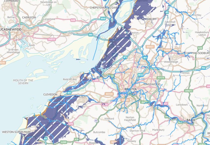
231.4.6. Underground Mines and Workings All of the four Unitary Authorities in the AF&RS service area have disused underground coal mines; the boxed areas of Figure 1.6 show where these mines are located. It also shows the ‘Development High Risk Areas’ which contain the potential for instability or risk to the surface from the legacy of coal mining operations, in these areas there is a higher risk of sinkholes and subsidence (The Coal Authority, 2014). In 2008, mine workings collapsed in Yate under private woodland, taking the Coal Authority several months to rectify (Grudgings, 2008). Figure 1.6 Mine workings and risk in our Service Area (The Coal Authority, 2020). 1.5. Economy 1.5.1. Economic Cost of Fire In 2011, the Department for Communities and Local Government published a report looking into the economic cost of fire in England. The report found that the total cost of the fire was an estimated £8.3 billion to the economy in 2008; taking inflation into consideration this equates to just over £10.9 billion a year in 2018 (DCLG, The economic cost of fire, 2011). The report noted that between 2006 and 2008 that estimated cost had 24 Strategic Assessment 2021 v1.0
only changed by 1% from £8.2 billion to £8.3 billion; however, the way in which those
funds were spent had changed significantly.

The report found that the increase in the number of hours spent on community fire safety
and fire investigations added to Fire and Rescue Service (FRS) resource costs. While
the fire safety labour cost per hour rose with inflation, the actual number of hours FRSs
devoted to fire safety activities increased much more rapidly. According to the report, this
increase in costs had been offset by the overall decrease in the number of fatalities, each
costing an estimated £1.65 million (£2.18 million in 2018 with inflation), as well as non-
fatal casualties each costing an estimated £185,000 (£244,000 in 2018 with inflation) and
the reduction in arson which saw a decrease from £1.9 billion to £1.7 billion.

The NFCC are currently working on the ‘The Economic and Social Value of the UK Fire
and Rescue Service Project’, working with the Home Office, they aim to provide a refresh
of the Economic Cost of Fire report, and supply a digital toolset to improve risk
management planning; the report is on track to be published in June 2021, and delivery
of the toolset by July 2021.

1.5.2. Local Industry & Businesses
Between December 2020 and January 2021, most economic sectors were below their
February 2020 levels due to the economic impact of the COVID-19 pandemic (ONS,
2021).

The only sectors to see significant growth over the first year of the pandemic were the
repair of computers (12.7%), postal and courier services (12%), human health activities
(8.6%), auxiliary of financial services (7.7%) and real estate services (5.6%) (ONS,
2021). The sectors with the biggest decline were air transport (-93.6%), travel agency
tour operators (-88.7%), rail transport (-79.6%), accommodation (-79.3%) and creative
arts and entertainment (-68.7%). These figures are compared with February 2020
(ONS, 2021).

February 2020 figures showed there was roughly a 60/40 split across all industries
decline/ growth, whereas January 2021 shows around 75% of industries declined in
their growth with a select few industries experiencing minimal growth.

1.6. Planned Developments
1.6.1. Hinkley Point
Hinkley Point is on the edge, but outside, of the Service area. Hinkley Point B is
currently the only nuclear power station in or near the Service area which is operational;
the adjacent Hinkley Point A together with Oldbury and Berkeley power stations are
being decommissioned.

         Hinkley Point C
Hinkley Point C is currently under construction and is predicted to be completed in
2025; it is expected to produce nuclear power for 60 years. The construction will
produce 25,000 employment opportunities, and up to 1,000 apprenticeships (EDF,

25
2020). This indicates a potential for an increase in transient workers living in, or
commuting through, the Service area over the construction period.
Through the construction the road, rail, and port infrastructure in the Service area will be
used for the transportation of construction materials, including hazardous or abnormal
loads. Bristol Port has invested in measures to meet the ongoing requirements of the
Hinkley Point C development, including plans to barge abnormal indivisible loads to the
project site where they are too big to move by road (Sarens, 2019). However, abnormal
loads have in the past, and may still be, transported by road causing traffic delays in the
Service area (Malloy, 2018). Nuclear waste from Hinkley has also routinely passed by
rail through the Service area since the mid-1960s (Office for Nuclear Regulation, 2013).
Connecting Hinkley Point C to Seabank
This proposed new transmission project will allow for Hinkley Point C to become safely
connected to the GB transmission network, making it one of the largest extensions of
the transmission network in recent decades (OFGEM, 2020). The project will also
provide additional capability and relieve transmission constraints in the South West of
England (National Grid, 2019).
National Grid are proposing to remove 65 kilometres (40 miles) of existing 132,000-volt
overhead line between the Bridgwater and Avonmouth substations and put up 46.6
kilometres (29 miles) of 400,000-volt overhead line. Over eight kilometres (five miles) of
the new connection passes underground through and either side of the Mendip Hills
Area of Outstanding Beauty (AONB), leaving this part of the Mendip Hills free from
pylons for the first time in more than 40 years. Eight kilometres (five miles) of existing
132,000-volt overhead line from Nailsea to Portishead substation is to be underground
(National Grid, 2019).
1.6.2. Nuclear Fusion Plant
In 2020, the UK Government announced £220 million of funding for the UK Atomic
Energy Authority (UKAEA) to design and build a prototype fusion power plant, with
operations to begin in 2040 (UKAEA, 2020). Fusion power offers the opportunity to
deliver safe, carbon-free, abundant, base-load power; which is said to avoid the risks
associated with fission power (Windsor, 2019).
A bid is being launched for the decommissioned sites at Oldbury and Berkeley to house
a fusion plant prototype. UK Fire and Rescue Services will need to consider the risk
posed by this new technology and, along with partner agencies, ensure they are able to
respond to emergencies.
1.6.3. Battery Energy Storage Systems
Battery energy storage systems (BESS) are experiencing rapid technological
development, presenting an evolving range of significant risks. These risks include fire
and explosion, chemical hazards, physical hazards, electrical hazards, and stranded or
stored energy (UK Government, 2020).
26 Strategic Assessment 2021 v1.0The number of installed units of domestic BESSs is still limited, and there are currently
no statistics for fires involving domestic systems. However, industrial, domestic and
transportation incidents involving BESSs are reported in the public domain (UK
Government, 2020). These include fires in Samsung smartphones, the Boeing 787
Dreamliner jet fire at Heathrow Airport, and fires at BESS facilities (AIG, n.d.).
1.6.4. Road Developments
Infrastructure
The M4 and M5 motorways run directly through the AF&RS area. At peak times, these
main arterial routes to Wales and the South West often run close to, or at capacity.
Should a major road traffic collision occur on one of these motorways, the impact will be
felt across the Service area as traffic will attempt to migrate through the Bristol and ‘A’
roads with the potential to cause disruption. Situations such as this are fortunately rare
but can have a massive impact on how AF&RS deploys its assets effectively to maintain
the response standards.
There are a number of planned road developments in the Service area to address the
pressures on the road infrastructure. The West of England’s Joint Local Transport Plan
is led by the Unitary Authorities to create “a well-connected sustainable transport
network that works for residents across the region” by 2036. It will provide better travel
choices and encourages walking, cycling and public transport (Travelwest, 2020).
Figure 1.7 below shows the major schemes planned by the Joint Transport plan up to
2036.
Figure 1.7 South West Joint Local Transport Plan Major Schemes (Travelwest, 2020).
27In addition, Highways England’s construction of the new junction of the M49 near
Avonmouth has now been completed, and is now awaiting the developers to build in the
connecting roads (Highways England, 2020).
This developing nature of road transport places new demands on AF&RS. These
include:
Vehicle risks – AF&RS need to ensure operational crews are up to date with
technical knowledge of vehicle construction and the hazards and risks associated
with rescue in the event they are involved in a collision.
Emerging vehicle technologies – See also 1.6.4.3 Electric Vehicles. The
application of water onto burning lithium batteries in vehicles can produce toxic
Hydrogen Fluoride Gas; this has a lethal dose of 100mg per cubic metre of air.
There can be between 2 and 20kg of gas released when these vehicle batteries
are involved in fire (Larsson et al., 2018). Specialist extinguishing media is
required to minimise the release of this gas.
Service road usage profile – AF&RS need to have a good understanding of the
potential hazards and volume of these hazards travelling on roads within its
service area to ensure sufficient pre-planning, staff, equipment, and resources
are available to deal with any potential incidents. AF&RS should also be aware of
the potential changes to road usage as a result of the COVID-19 pandemic’s
‘new normal’, with the normalisation of home working expected to reduce the
number of road users. Whilst this has the benefit of alleviating congestion, there
is also potential for more cars to be parked on-street through the day, creating
access issues for appliances responding to incidents through narrower streets.
Spills/pollution from Road Traffic Collisions (RTCs) – need to prevent
pollution and protect the environment as per Environment Agency best practice.
Work to develop and improve the road transport infrastructure inevitably means more
roadworks, which, if not managed appropriately, have the potential to slow down the
response times of all the emergency services.
Clean Air Zones
Concern over air quality issues in our cities has now been declared a public health
emergency. Both Bristol and Bath have long-standing air quality issues which cause
harm to people’s health.
Recent research shows that the high levels of air pollution in Bristol contribute to five
people dying prematurely each week. It also estimates that children born in 2011 in
Bristol will die up to six months early due to lifetime exposure to air pollution. The most
concerning pollutants within Bristol are nitrogen dioxide (NO2) and very small
particulates, which are invisible. The main source of NO2 pollution is road traffic with
diesel vehicles contributing around 95% in Bath and Bristol combined. Of this, diesel
28 Strategic Assessment 2021 v1.0You can also read