Strategic Missions - Earth Science - Dr. Michael Freilich October 2016 - National Academies
←
→
Page content transcription
If your browser does not render page correctly, please read the page content below
Strategic Missions - Earth Science
Dr. Michael Freilich
October 2016

                                     1
Earth Science Division Objectives and Activities

 Understand the Earth as an integrated system, and
 develop and test applications to deliver direct societal
 benefit
 •   MEASUREMENTS: Monitor/observe the Earth and our
     environment from space to advance science, develop applications for
     societal benefit, and support other mission agencies. NASA designs,
     implements, and operates present and future spaceborne observing
     systems

 •   RESEARCH: Understand the Earth as an integrated system through
     multidisciplinary research, using all relevant measurements (not just
     spaceborne, not just NASA)

 •   SOCIETAL BENEFIT and CAPACITY BUILDING: Develop and
     test new information products that are tailored to the needs of end
     users; increase users’ capacity to exploit the information

 •   TECHNOLOGY DEVELOPMENT: Advance instrument, data
     processing, and communications technologies to support new
     missions, research, and applications                                    2
Formulation
  (Pre)Formulation
  Implementation                   MAIA (~2021)
                                   TROPICS (~2021)                                                                                      Landsat 9
  Primary Ops
                                   EVM-2 (~2021)                                                                                              (2020)
  Extended Ops                                                                                                                   PACE (2022)
                                                                                                                          NISAR (2022)
                                                                                                                   SWOT (2021)
                                                                                                             TEMPO (2018)
                                                                                       JPSS-2 (NOAA)
                                                                                       RBI, OMPS-Limb (2018)                     InVEST/Cubesats
Sentinel-6A/B (2020, 2025)
                                                                             GRACE-FO (2) (2017)
Earth Science Instruments on ISS:                                                                                             MiRaTA           (2017)
                                                                   ICESat-2 (2017)
RapidScat, (2017)                                                                                                             RAVAN            (2016)
                                                           CYGNSS (2016)                                                      IceCube          (2017)
CATS, (2020)
LIS, (2016)                                        ISS                                                                        HARP             (2017)
                                                         SORCE, (2017) NISTAR, EPIC (2019)                                    TEMPEST-D        (2018)
SAGE III, (2016)                                         TCTE (NOAA) (NOAA’S DSCOVR)
TSIS-1, (2018)                                                                        QuikSCAT (2017)                         RainCube         (2018*)
ECOSTRESS, (2017)                                                                                                             CubeRRT          (2018*)
GEDI, (2018)                                                                                                                  CIRiS            (2018*)
OCO-3, (2018)                                                                                  EO-1
CLARREO-PF, (2020)                                                          Landsat 7          (2017)                         CIRAS            (2018*)
                                         SMAP (>2022)                       (USGS)
TSIS-2 (2020)                                                  Terra
                                                               (>2021)      (~2022)
                              Suomi NPP                                                                                       LMPC             (----)
                              (NOAA) (>2022)             Aqua(>2022)

                                                              CloudSat (~2018)                                                *Target date, not yet
                             Landsat 8                                                                                         manifested
                             (USGS) (>2022)
                                                                             CALIPSO (>2022)

                              GPM (>2022)                                               Aura
                                                                                        (>2022)
                                                                                                        GRACE (2)
                                                                                                        (2018)
                                                                                                                     OSTM/Jason 2 (>2022)
                                                                                                                     (NOAA)
                                         OCO-2
                                         (>2022)                                                                                                   3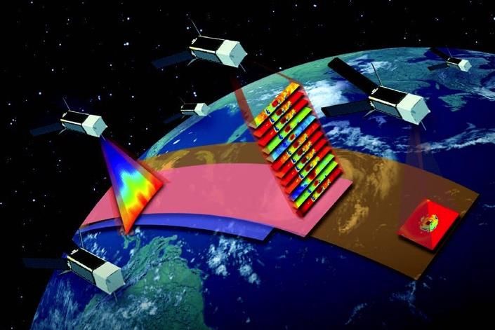
Missions - Classification
Large Observatory                      Focused          PI-Led       Instrument        Smallsat

     Aqua                               GPM             GRACE          RapidSCAT            CYGNSS* (8)
     Aura                               OCO-2           Cloudsat       CATS                 TROPICS* (12)
     Terra                              Landsat-7                      TEMPO*               RAVAN
     Suomi-NPP                          Landsat-8                      RBI                  MiRaTA
     [JPSS-2]                           Landsat-9                      TSIS-1/2             ICECube
                                        GRACE-FO                       MAIA*                HARP
                                        QuikSCAT                       SAGE-III             TEMPEST-D
                                        EO-1                           ECOSTRESS*           RainCube
                                        Calipso                        GEDI*                CubeRRT
                                        NISAR                          OCO-3                CIRAS
                                        ICESat-2                   OMPS-Limb        CIRIS
                                        SWOT
                                        NISAR
                                        PACE
                                        SMAP
                                        Jason-2
                                        Jason-3
                                        Sentinel-6A/B
                                        SORCE
                                        PACE
                                        [DSCOVR]

*Earth Venture Instrument or Mission
                                                                                                     4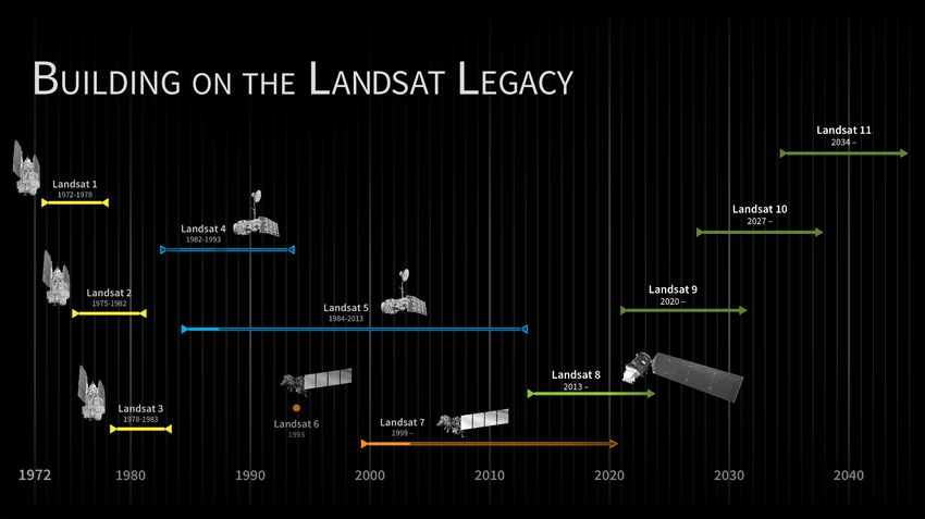
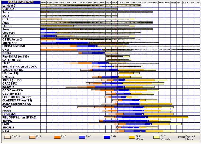
Mission Schedules (Pre-Phase A through Phase E)

                                                                        Preliminary – Under Review

                                                                                                                                   5
  Note. Continuity for Jason CS/Sentinel 6A and Landsat-9 are planned through Jason CS/Sentinel 6B and Landsat-10, respectively.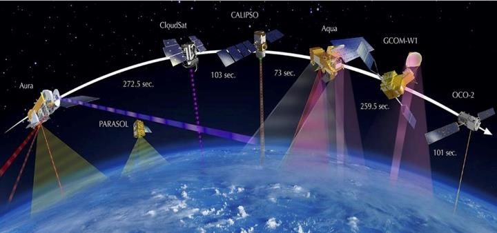
Recent Flight Mission Gate Review Progress
•   RBI KDP-B:          29 March 2016
•   OCO-3 KDP-C:        12 May 2016
•   SWOT KDP-C:         19 May 2016
•   TSIS-1 KDP-C:       6 June 2016
•   GEDI KDP-C:         9 June 2016
•   PACE KDP-A:         16 June 2016
•   Landsat-9 KDP-B:    14 July 2016/17 Aug 2016 (APMC)
•   RBI KDP-C:          26 July 2016
•   NISAR KDP-C:        23 Aug 2016
•   SAGE-III KDP-E:     27 Sept 2016
•   CYGNSS KDP-E:       21 Oct 2016      Legend:
                                         Bold: Confirmation/KDP-C
•   CLARREO-PF KDP-A:   Dec 2016         Red: Initiation of new mission
•   ICESAT-2 KDP-D:     Sept 2016        Green: Near-future
                                                                     6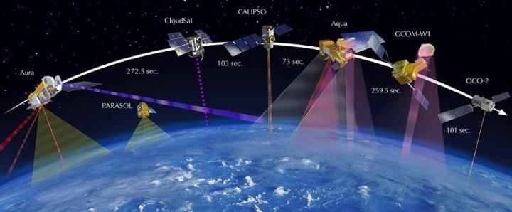
Small Satellite CONSTELLATIONS
• Cyclone Global Navigation Satellite System
  (CYGNSS)
   – Selected under Earth Venture Mission-1 AO
   – 8-satellite Microsat Constellation to measure winds
     and air-sea interactions in tropical storms, using
     reflected GPS
   – Ready for launch scheduled for 21 Nov 2016
   – PI-led (C. Ruf, U. Michigan, plus SWRI)

• Time-Resolved Observations of Precipitation structure and storm
  Intensity with a Constellation of Smallsats (TROPICS)
   – Selected under Earth Venture Instrument-3 AO
   – 12-satellite Cubesat Constellation
   – First science-focused cubesat constellation
   – Targeted for launch in 2020, may use VCLS
      vehicle
   – PI-led (W. Blackwell, MIT, plus Lincoln Labs
     and WFF)
                                                                    7
Small Satellite Constellation Initiative
• FY18 Budget augmentation to ESD to explore strategic approaches for the
  acquisition of measurements by small-satellite constellations, and the
  potential of these products to advance NASA's Earth system science and
  applications development goals.

• RFI NNL16ZB1006L released July 12, 2016; 4 responses received by
  August 12, 2016
   – Requested information about the feasibility of purchasing from the private sector, and
     evaluating, small-satellite data products that might augment or even replace NASA-
     collected data
   – Identified GNSS Radio Occultation (GRO) and moderate resolution, multispectral,
     spatially and temporally extensive land imaging data as possible acquisition targets
   – Strong industry responses (Planet, GeoOptics, Surrey, UrtheCast), including one cover
     letter stating, “We applaud NASA for the foresight shown in this RFI call to move beyond
     the historical government-to-contractor relationship in favor of putting itself in the position
     of an interested consumer.”

• Will likely proceed with an RFP if Congress appropriates the FY17 budget
  request for ESD
   – The RFI noted that NASA may invest up to $25M total in ~2 data purchases in FY18 8
Venture Class Launch Services (VCLS)

• Joint ESD/NASA Launch Services Program initiative
• RFP released 12 June 2015; Selections announced 14 Oct 2015
• Funded with $10M from ESD
   – Selected launches will:
       • Accommodate 132 pounds (60 kilograms) of CubeSats on 1
         or more launches
       • Launch(es) must occur by April 15, 2018
• Selectees:
   –   Rocket Lab USA, Inc. (first VCLS launch 6/2017)
   –   Virgin Galactic LLC (first launch 7/2017, 1st VCLS launch 11/2017-4/2018)
   –   Firefly Space Systems, Inc. (first VCLS launch 3/2018)
   –   Total NASA costs per selectee/launch are < $15M

  Tangible and substantial ESD investment in small launch vehicles
                                                                                   9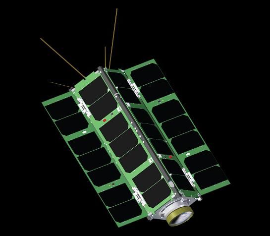
Committee Questions:
Strategic Science
• For Earth system science and applications development/demonstration,
  strategic, integrative science requires sustained, frequent measurements
  of many different quantities (e.g., the GCOS “Essential Climate Variables”)
• Measurements are accumulated from the overall NASA (and other-
  organization) on-orbit portfolios
• Near-simultaneous sampling of different quantities from heterogeneous
  constellations has been demonstrated and used routinely (A-Train; TIR for
  Sentinel-2A planned by Europeans)
• Assimilative global, system models are developed both outside and within
  the NASA R&A program, with model outputs often used as proxy “data.”
• 2007 ESAS Decadal Survey did not recommend a single “flagship”
  mission for ESD or the nation – breakthrough science does not come from
  analysis of measurements from any single mission
• Overall Administration and private sector foci emphasize robust
  constellations of (possibly heterogeneous) small satellites/missions, not
  large flagship, strategic, single missions

                                                                                10
Heterogeneous Mission Constellations: A-Train
Aqua (2002-present) - NASA
• Coordinated formation-flying Multi-
Aura (2004-present) - NASA
mission integrated, “near-
CALIPSO (2006-present) – NASA/CNES
instantaneous” products
CloudSat (2006-present) - NASA
GCOM-W1 (2012-present) - JAXA • International participation (ex-
PARASOL (2004-2013) – CNES PARASOL, GCOM-W) 11
OCO-2 (2014 launch) - NASAESSP Missions – Earth Venture Overview
• A sustained, successful Venture-class element is a priority from the Decadal Survey
• Advances science/applications and promotes community involvement through frequent, regular proposal
opportunities
• Ensures overall program scientific flexibility and responsiveness through constrained development
schedules
• Complement the systematic missions, provide flexibility to accommodate scientific advances and new
implementation approaches
• Can provide complementary science to the Decadal Survey Missions but does not replace them.
• All ongoing and planned investigations, solicitations, and selections are on track and fully funded
3 “Strands”
Sub-Orbital Small-sat/Missions InstrumentVenture Class Selections/Solicitations
Release Selection
Mission Mission Type Major Milestone
Date Date
EVM-2 Full Orbital FY15 FY16 Launch ~2021
EVI-4 Instrument Only FY16 FY17 Delivery NLT 2021
EVS-3 Suborbital Airborne Campaigns FY17 FY18 N/A
EVI-5 Instrument Only FY18 FY19 Delivery NLT 2023
EVM-3 Full Orbital FY19 FY20 Launch ~2025
EVI-6 Instrument Only FY19 FY20 Delivery NLT 2024
EVI-7 Instrument Only FY21 FY22 Delivery NLT 2026
EVS-4 Suborbital Airborne Campaigns FY21 FY22 N/A
EVI-8 Instrument Only FY22 FY23 Delivery NLT 2024
Open solicitation
Completed solicitation
EVS-1: CARVE, ATTREX, DISCOVER-AQ, AirMOSS, HS-3
EVM-1: CYGNSS (21 Nov 2016 LRD)
EVI-1: TEMPO (2019-; 2017 instrument delivery) – hosted payload on
GEO comm sat
EVI-2: GEDI (2019; 2018 del.); ECOSTRESS (10/2017; 5/2017 del.)
EVS-2: ATom, NAAMES, OMG, ORACLES, ACT-America, CORAL
EVI-3: MAIA, TROPICS
EVM-2: Selection(s) likely in Q4 CY2016 13Committee Questions:
Capability and Leadership
• What concerns do you have about how long flagship missions take for
development and the difficulty for young researchers or even potential
future PIs to gain experience?
• N/A
• Vigorous program of directed instruments, cubesats (InVEST), Venture
Class –Instrument and –Mission provide many frequent and varied
opportunities for instrument PI’s
• What is the value of flagship missions for science base concerns? Talent
pools, corporate knowledge, continuity of capabilities etc., and the impact
on the future health of this support base?
• None
• What is the role of international [interagency] partnerships in strategic and
flagship missions? How is this different for other classes of missions?
• Only ESA has flown flagship research missions in the past 12 years;
and now, with the Copernicus system, all future missions are focused
• NOAA and EUMETSAT continue to develop and fly multi-instrument,
strategic large observatories to support meteorological prediction
• ESD participates in partnerships for focused and small missions
14Committee Questions:
Technology Development
• Do you have a separate technology development line?
• Yes: The Earth Science Technology Office (ESTO) - ~$60M/year
15Earth Science Technology
• Advanced technology plays a sustained role enabling Earth research, applications, and
flight missions.
• The Earth Science Technology Program (ESTP) enables new science investigations;
improves existing measurement capabilities; and reduces the cost, risk, and/or
development time of earth science instruments and information systems.
• A rigorous approach to technology development is used through analyses of science
requirements for technology needs; selecting and funding technologies through
competitive solicitations and partnership opportunities; actively managing funded
technology development projects; and facilitating the infusion of mature technologies
into science campaigns and missions.
Advanced Technology Initiatives (ATI) Instrument Incubator Program (IIP) - robust new
instruments and measurement techniques
Advanced Component Technologies (ACT) - development of Future solicitations/selections planned in FY16 and FY19
critical components and subsystems for instruments and
platforms
Future solicitations planned in FY17 and FY20
Advanced Information Systems Technology (AIST) -
innovative on-orbit and ground capabilities for
In-Space Validation of Earth Science Technologies (InVEST) - communication, processing, and management of remotely
on-orbit technology validation and risk reduction for small sensed data and the efficient generation of data products
instruments and instrument systems that could not otherwise Future solicitations/selections planned in FY16, FY18 and
be fully tested on the ground or in airborne systems FY20
Future solicitations planned in FY18 and FY21
16U-Class Candidate Development Satellites
ESTO Technology Developments for Future Earth Science
Measurements
Venture Tech ESTO InVEST 2015 Program
TEMPEST-D
Colorado State University
RainCube CubeRRT
Jet Propulsion Lab Ohio State University
Precipitation Radar Radiometer RFI
Validate a new Demonstrate
architecture for Ka- wideband RFI mitigating
band radars on backend technologies vital
CubeSat platform and for future space-borne
an ultra-compact microwave radiometers
deployable Ka-band
antenna
CIRiS CIRAS
Ball Aerospace Jet Propulsion Lab
5 Frequency mm-Wave
Radiometer Infrared Radiometer Infrared Atmospheric Sounder
Technology demonstrator Validate an uncooled Demonstrate ability to measure
measuring the transition of clouds imaging infrared (7.5 um spectrum of upwelling infrared
to precipitation to 13 um) radiometer radiation and validate 2D
designed for high infrared detector material, a
radiometric performance micro pulse tube cryocooler, and
from LEO a grating spectrometer
17ESTO InVEST 2012 Program
U-Class Satellites Advancing TRLs for Future Earth Science
Measurements
MiRaTA RAVAN IceCube HARP LMPC
MIT / MIT-LL APL GSFC UMBC The Aerospace Corporation
3 Frequency Radiometer and Vertically Aligned Carbon 874 GHz submm-Wave Wide FOV Rainbow Photon Counting
GPSRO Nanotubes (VACNTs) radiometer Polarimeter InfraRed Detector
Validate new microwave Demonstrate VACNTs as Validate sub-mm Demonstrate 2-4 km wide Demonstrate linear mode
radiometer and GPSRO radiometer absorbing material radiometer for spaceborne FOV hyperangular single photon detector at 1,
technology for all-weather and calibration standard for total cloud ice remote sensing polarimeter for cloud & 1.5, and 2 microns in space
sounding outgoing radiation aerosol characterization environment
18Sustainable Land Imaging (SLI)
• A 3-component program – in partnership with USGS – for a sustainable,
continuous, global land imaging system through 2035, consistent with the
existing 44-year Landsat record:
• Landsat 9 (fully Class-B rebuild of Landsat 8) targeted to launch in FY 2021
• Low programmatic risk implementation of a proven system with
upgrades to bring the whole system to Class B – includes 30 m res.
multispectral and 120-m thermal IR measurements (like Landsats 7, 8)
• Land Imaging Technology and Systems Innovation
• Hardware and data processing investments to reduce risk in next
generation missions and inform future system architecture decisions
• Landsat 10 (Class B multispectral and Thermal IR) to launch ~2027-2028
• Mission architecture to be informed by the technology investments
(2015-), leading to mission definition ~2020
19Earth Science Technology Highlight
Six Projects Awarded under Sustainable Land Imaging-Technology (SLI-T)
On August 2, six new projects (of 33 received proposals) were announced under the first solicitation of the Sustainable Land
Imaging-Technology (SLI-T) program (element A.47 of ROSES-15). The SLI-T program was created to research, develop, and
demonstrate new measurement technologies that improve upon current land imaging capabilities, while at the same time
reducing the overall program cost for future measurements.
This first solicitation sought proposals to:
• Demonstrate improved, innovative, full-instrument concepts for potential infusion into the architecture and design of
Landsat-10; and
• Develop and mature technologies that have long-term potential to significantly improve future land imaging
instruments and systems through substantial architecture changes.
The first-year funding for these investigations is approximately $6.5M.
Compact Hyperspectral Prism Spectrometer (CHPS)
PI: Thomas Kampe, Ball Aerospace & Technologies Corporation
Advanced Technology Land Imaging Spectroradiometer (ATLIS)
PI: Jeffery Puschell, Raytheon Corporation
Integrated Photonic Imaging Spectrometer
PI: Stephanie Sandor-Leahy, Northrup Grumman Systems Corporation
Reduced Envelope Multi-Spectral Imager (REMI)
PI: Paula Wamsley, Ball Aerospace & Technologies Corporation
Long Wavelength Infrared Focal Plane Array for Land Imaging
PI: David Ting, Jet Propulsion Laboratory
Multi-Spectral, Low-Mass, High-Resolution Integrated Photonic Land Imaging
Technology - PI: Ben Yoo, University of California, DavisNASA-USGS Interagency Partnership
- NASA: Space Segment and Launch
- USGS: Operations & Data Processing/Distribution
L a n d s a t 9 K D P - B A P MC A u g u s t 1 7 , 2 0 1 6 NASA GSFC • USGS EROS 21Committee Questions:
Technology Development
• Do you primarily use flagship missions for technology development?
• No. Technology development is done primarily – almost exclusively – in
ESTO.
• Cat-III selections as technology development (not mission) elements are
managed by ESTO (e.g. TEMPEST-D, Green-OAWL, both resulting from
EVI-2)
• Can you afford the risk of including new technologies on flagship missions?
• No. ESD does not originate flagship missions. Bad experiences with
partner-developed new-technology instruments on partner-originated
flagship missions (e.g., VIIRS on Suomi-NPP). Focused-but-strategic
missions (e.g. Landsat) generally involve partner (non-space) agencies
and communities who are risk-averse and schedule/performance
sensitive.
• Can you do technology development with smaller size missions?
• Yes. When developed in a mission context outside of ESTO, the new
technology is confined to non-threshold capabilities (e.g. Laser Ranging
Interferometer on GRACE-FO)
• Do you treat new technology at all differently on flagship missions vs. small
missions (by, for example, incentivizing missions to use new technologies)?
• N/A
22Committee Questions:
Cost Control for Large Missions
• How do cost overruns on flagship class missions affect the
other mission classes in your portfolio?
• N/A – No ESD flagship missions. Any cost overrun on a directed
mission is accommodated within the ESD budget (or mission is
terminated - e.g. GPM LIO) with due regard to balance and priorities
into the future.
• Venture Class budget and solicitation cadence are never changed to
accommodate other ESD budget needs.
• How do you address cost overruns on flagship missions vs.
how you address cost overruns on smaller class missions?
• N/A – No difference, no flagship missions.
• Venture Class cost caps are scrupulously observed – no exceptions,
ever.
23You can also read